On the way to Å

This article is part of the series “2015-07: Lofoten and Vesterålen”.

Day one

Å is not only the last letter of the Norwegian alphabet, it’s the name of some places, too. The probably most known  is Å i Lofoten, the southmost village of the Lofoten islands.

Delle, a German friend of mine and I started the tour last Saturday. The only plan was to take the car, drive to Bodø and take a ferry to the Lofoten islands, the same day or the other day.

The weather in Skelleftehamn was fine but in Arjeplog, where we made a lunch break it started to rain. We continued our trip to Bodø over the mountains. They were wrapped in clouds and were still partly covered with snow.

17:30 we arrived in Bodø, just in time to get the ferry to Moskenes on the Lofoten. Normally I love to be outside all the time when I’m on a ship but this time the sky was so grey that you hardly could see anything. The Lofoten with its more than 1200 meter high mountains came in sight just some minutes before we arrived.

We left the ferry with Delle’s car and drove the 5 km to Å, where it rained so much, that we decided not to put up our tent but to sleep in the car. I put on my rain cloth and made a short evening walk but soon returned to the car. The only pictures I made that evening were the fish heads on the wooden racks drying in the salty wind.

From Å to Rystad

This article is part of the series “2015-07: Lofoten and Vesterålen”.

Day 2

Next morning when we woke up in Å we could see blue sky through the fogged car windows. The rain has stopped. We made a walk through the little fishing village and had breakfast on the cliff with a fantastic view on the mountains and the sea.

After that we continued our trip through the incredible landscape of the Lofoten. We had to stop several times to take pictures, for example of this small mountain lake near the road to Nusfjord:

Later we came to a place that became quite famous over the years: Uttakleiv – a beautiful sandy beach that just invites you to jump into the turquoise-coloured water. It almost looks Caribbean but as soon as you enter the ice cold water you’re reminded of being in Northern Norway, not in the south. The bath was fun, anyway.

Here we stayed for a while and enjoyed the sun. But after a while we continued our road trip to Brenna on the island Austvågøy. We didn’t find a camping ground at the end of the road and turned, but soon we stopped the car again. Actually because I wanted to take pictures of the sheep that lay at the sandy beach, but some children nearby discovered something much more interesting: A fox cub. I changed to the telephoto lens and I came quite near. Probably the fox hadn’t made any bad experiences with humans yet.

After that we stopped at a camping ground near Rystad that we already saw on the way to Brenna and decided to stay overnight. Soon the tent was put up on the grassy ground. Slowly the sun went round the mountains and sank down. The next hours were incredible – the light was so wonderful, both the sunlit main land in the south and the sea in the north glowed in the most fantastic colours. But have a look by yourself:

Round one o’clock we lay down in our tent, but only because clouds came and it started to rain a bit. What a wonderful first day on the Lofoten!

Continuing to the Vesterålen

This article is part of the series “2015-07: Lofoten and Vesterålen”.

Our third day started with a lot of rain. We put the wet tent into the car and continued our tour to Kabelvåg where we visited a friend of mine. We took a small mountain hike but it was cloudy and wet. Only far away in the east you could see some sunny patches on the top of the snowy mountains.

After the hike Delle and I looked for a camp ground. But first I had to take a picture of the beautiful rainbow near Sildpollen.

This time we tented on a bigger campsite in Sandsletta. When I woke up quite early the next day I could see another rainbow over the Vatnfjorden, but later it started to rain and pour down again. And again we put the soaked tent into the car. We continued on the road 888 to Fiskebøl. The clouds were hanging low and you could hardly see any mountain, just some white and light grey schemes.

Soon we arrived in Fiskebøl where we waited for the ferry. Again we were lucky – we waited hardly half an hour until we entered the ferry for the short crossing to Melbu, the southernmost city of the Vesterålen. We visited friends of mine, this time in Haukenes were we tented near the friend’s house. The cocks tried to wake me up ridiculously early, but in vain. I continued sleeping until 8 o’clock.

Alas it was the first morning without rain (and the only one, too) and we could dry the tent. After a long and lazy breakfast with my friends we said farewell and continued our car trip. We got a tip to visit Stø at the northern end of the Vesterålen island Langøya. What a good tip and what a beautiful landscape – especially after the weather was nice and sunny. We made a short photo stop between Strengelvåg and Klo before we continued to Stø.

In Stø we parked our car and took a short hike over the mountains to a beautiful white sanded beach were we made a rest and I took a short bath. There’s a 15 km hiking trail as well; next time I’ll definitely will go it.

After our rest we slowly walked back and continued by car. First we had to head south to Sortland were we crossed the Sortlandsundet and headed north on the other side. The sky became more and more cloudy and we looked for a nice campground. Finally we found one in Bleik, quite near Andenes, a town at the northern end of the Vesterålen. We put up the tent and – guess what – it started to rain.

It had been raining the whole night and it continued raining. Again a soaking wet bunch of a tent lay in the back of the car. After a while of driving through the greyness we decided to head back to Skelleftehamn. It’s more than 900 kilometres and it took the whole day. Rain became less near Abisko and after we passed Jokkmokk the sky cleared up and we could see the full moon slowly rising. The next photo, which is the last of our car trip through the Lofoten and Vesterålen is taken near Storforsen, one of Europe’s biggest rapids. At 23:50 we were in Skelleftehamn again – and I was home.

  • 2296 kilometres in six days
  • a lot of clouds and rain, but two nice and sunny days, too
  • one night in the car, four in the tent (three of them on campgrounds)
  • two bathes and at least four rainbows
  • – a nice trip!


For the longhorn beetle enthusiasts …

Both longhorn beetles found in Bygdeträsk. The Leptura quadrifasciata on Friday, the Lepturobosca virens today.

Translations:

EnglishGermanSwedish
Longhorn beetleBockkäferLånghorningar
Leptura quadrifasciataVierbindiger SchmalbockFyrbandad blombock
Lepturobosca virensDichtbehaarter HalsbockGrön blombock

Cloudberries – the gold of Lapland

The very short version:

The longer version for those who don’t know these berries:

These berries are called cloudberries (German: Moltebeere, Swedish: hjortron, Norwegian: multe). Cloudberries like bogs and wetlands where they bloom and bear fruit in July and August. That’s exactly the heyday of the mosquitos, that like bogs and wetlands, too. The berries are found quite outspread and it takes some efforts to collect them. (Remember the wetlands? Remember the mosquitos?)

Cloudberries have a quite special taste. I love them but not all share this liking. They are very healthy and contain three times more vitamin C than oranges.

I went berrying yesterday and checked some bogs near Bygdeträsk, where I stayed the weekend with good friends. I wasn’t very lucky. I hoped I would find enough of them to freeze them for later use, but this small amount will not survive the next days. But I was lucky in another way: hardly any mosquitos.

But I found other things. A small deep pond in the middle of the first pond, a so-called bog pond. If you stand beside such a bog pond you should remember that you’re standing on water or mud, that silted up and became overgrown. Be careful, this ground can be very treacherous!

And I found another thing: A plant, that’s special because it’s flesh-eating: A sundew. What a pity that it didn’t bloom yet.

Sundew is quite common here and grows on wet patches and mud. This one, however, grew directly on water that was covered with just one millimetre of peat. I never saw this before.

By the way: I met a neighbour today, he went cloudberry picking as well. He was a bit disappointed because he picked only 4 kilos. I definitely have to check more bogs to find better places.


Translations:

EnglishGermanSwedish
cloudberriesMoltebeerehjortron
to silt upverlanden
sundewSonnentausileshår
peatTorftorv

An overnight stay on the island Gåsören

Saturday

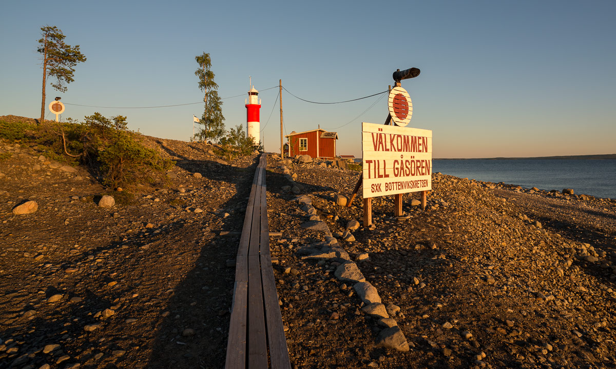
The advantage of short kayak trips with overnight stay: you can start quite late. It was 7 p.m. when I started pulling my loaded kayak from home to shore. A quarter later I sat in the kayak and started paddling. It’s only four, five kilometres to the island Gåsören that shone in the warm light of the evening sun.

The first thing to do: Put up the tent before sundown. The second thing to do: Taking a picture of the lighthouse before sundown. The stomach reminded me of thing number three: Preparing food and eating. Todays dinner: Graved salmon on fire roasted bread à la plein air.

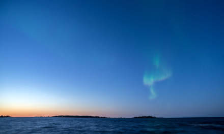
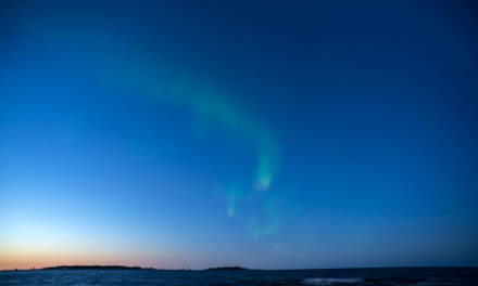
I was quite curious if I would catch the first polar light. The short term forecast of Soft Serve News wasn’t too bad. But even if the sun already went down round 9 o’clock – two and a half hours earlier than eight weeks ago – I still had to wait for the sky getting darker. After a while however I could see the first faint greenish garlands. My first Northern Lights of the season 2015/16! Great!

But then I saw something in the sky that I thought was much more fascinating: Right above the red coloured northern sky I could see a layer of lucent clouds. They looked really strange because there weren’t red or purple – they were pale white! I never saw something like that before. They looked extremely far away, almost extraterrestrial. I wondered if this perhaps could be noctilucent clouds – clouds that are found in extremely high altitudes of round about 80 kilometres. I stayed awake for a long time, I just couldn’t tear my eyes away from this wonderful phenomenon. Two pictures of the clouds:

Of course I checked my hypothesis directly, when I went home. Yes – I guessed right. My first noctilucent clouds ever. I was really lucky and I’m happy that I could see them just from my tent.

But let’s leave the Mesosphere and go back to earth again. If you tent on the island Gåsören, you can see other lights, too. Lights of civilisation: The peninsula Rönnskär is quite nearby. On Rönnskär there is Boliden Rönnskär, one of the most efficient copper smelters. You think industry is unsightly and ugly? Well, not Rönnskär by night in my opinion:

Sunday

I woke up in broad daylight although it was only half past five. I took one halfhearted picture out of my tent and then I started reading.

I started the book “Norwegen der Länge nach” written by Simon Michalowicz that was published just some weeks ago. Simon hiked from the Southern tip of Norway to the North Cape – round about 3000 kilometres.

I read in the tent – I read sitting in front of the island’s sauna — I read sitting or lying on a floating boat bridge, only interrupted by a short bath in the Baltic Sea. I followed Simon’s tour and just couldn’t stop reading. It was noon when I finally finished the book. If can warmly recommend it to all German readers that love Scandinavia or are interested in hiking. There’s a website as well: www.simonpatur.de.

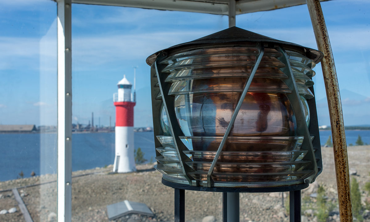
I wasn’t alone on the island. Some people hired the old lotshus – the pilot’s house for an overnight stay. The first motor boats came in for a day visit. And both summer cottages – there’re only two on Gåsören – were used, too. From T. who owns one of the cottages I learned that it was international lighthouse day today. So before I packed all my stuff together and paddled home I went up the two stairs in the old lighthouse and made a last photo.

I was home again half past two. Many experiences and a good book in less than twenty hours – that’s a fine weekend.

Translation:

EnglishGermanSwedish
Noctilucent cloudsLeuchtende NachtwolkenNattlysande moln

Tour planning

One working day left until the next holidays: Two weeks hiking in the Swedish and Norwegian mountains together with Annika. I’m really looking forward to the tour!

  • Start: Nikkaluokta. End: Abisko. Or Riksgränsen. Or somewhere in Norway. We’ll see. It will depend a bit on the conditions …
  • Conditions: Probably quite wet and soggy ground, perhaps even some larger snow fields. Summer came late this year and especially the mountain regions got quite cold and wet weather …
  • Weather: But now the forecast looks great: Quite warm and sunny weather. Probably I’ll sweat a lot, since it was long ago that I hiked with a backpack …
  • Backpack: approx. 21 kilos including the backpack itself and food. And about 4 kilos photo equipment …
  • Photo equipment: Nikon D800 · Gitzo 1541 tripod · 20 mm f/2.8 · 35 mm f/2.0 · 100 mm f/2.8.

My packing list is complete. Most of the todos are finished, but there is one very serious question left:

Which headgear is appropriate for such a tour?

Can you help me? I’m awaiting your comments.

Three weeks ago: Beautiful light on the lake Göksjön

Three weeks ago, when I visited friends in Bygdeträsk, A. und I made a boat tour on the lake Göksjön. We started in sunshine but soon dark clouds arrived and we shortened the boat tour in case of some incoming thunderstorms. But, as I hoped, it stayed calm and dry and the light on the way back was just incredible. When we landed the small boat, sky became blue again.