Travelling to the Varanger peninsula

This article is part of the series “2018-03: Varanger peninsula”.

Day 28 of my winter journey 2018

Yesterday Annika and I said good-bye to our friends Chris and Ørjan who live near the Snowhotel in Kirkenes. We wanted to continue to Vadsø on the Varanger Peninsula for an overnight stay. After breakfast, packing and saying good-bye we left at 11 o’clock. We followed the road 885 coming from Bjørnevatn and turned left into the E6 in direction Alta/Narvik. Right before the turnout to the airport we came to a stop. Some cars before us had stopped, one driver talking to a policeman. The other cars turned and we stood in the front. There we spotted a huge road sign “Closed, info telephone 175”.

The policeman told us that the E6 had been closed for some hours due to an avalanche that had to be blasted away. That could take some other hours. The E6 is not only the main road through Norway, it’s also the only way from Kirkenes to the Varanger Peninsula. So we returned to Kirkenes.

We ate some lunch, visited some shops and the library and waited for the road to be opened again. After some time it looked like the road would be opened round 14:00 so we gave it another try, were stopped again and told that the snow removal could take some more hours. We returned again, this time to our friends house ready to stay.

We went to the Snowhotel and told Chris about the road closure. Just after we told her that we would stay for another night the website informed us, that the road was usable again. I took a picture of the beautiful entrance hall made of snow and ice by a Russian artist, …

… we said good-bye one more time and took the very same roads again a third time. This time we were lucky, the road was opened and completely free of snow. We followed the E6 to Varangerbotn where we took the E75 to Vardø. Some hours later we were in Vadsø where we had our first couchsurfing experience.

Couchsurfing is a platform where people can host other people for free. It’s both great for finding a place to sleep and interesting people to meet. Our host, Nils Õun from Estonia was a really great host. He’s a professional cook and he made us a creative and gorgeous dinner. We talked and talked many hours and Annika and I were really glad to had the opportunity to meet him. Just a snapshot of the best chicken I ate in the last years, part of his dinner:

As I mentioned before was Nils a great host. Aitäh, Nils!

(Sneak preview: today we continued to Kiberg where we’ll stay for some nights. One of the nice and special places on the Varanger peninsula.)

A tour to the easternmost point of mainland Norway

This article is part of the series “2018-03: Varanger peninsula”.

Day 29 and 30 of my winter journey 2018

Yesterday we continued our journey to Ytre Kiberg which is 13 south of Vardø, one of the Hurtigruten stops. We started in Vadsø – another Hurtigruten stop – after a breakfast with our host Nils, bought a basis of food for the next days and took the E75 northwards. We made a stopover in Ekkerøy, a village on a peninsula near Vadsø. We like this place and will try to stay there for some nights next week.

At lunchtime we reached Cape East Arctic Adventure, our stay for four nights. We were welcomed by Trond, the owner and operator of Cape East Arctic Adventure and were shown our cozy bedroom, the kitchen and the homely living room. After making ourselves at home we went along the beach to the village and the harbour.

In the evening we were invited to a three course dinner based on freshly caught cod: Fish soup – cod with potatoes and carrots and finally cod roe. Everything was extremely tasty and it was Annika’s and my first time where we tasted cod roe. Yummy!

In Kiberg you are as east as you can be in the Central European Timezone, therefore sun is rising already at 6:24. I was awake very early and took a morning walk round 6 o’clock. Some snow drifts had been created by snow and wind over night but now the weather was less windy and quite sunny. At least for a short time. While I went the way to Indre Kiberg clouds approached, wind increased and it started to snow. It was hardly imaginable that it was sunny just a short time before. Weather changes here quite often as Annika and I should find out later.

After breakfast Annika and I took the car to the other side of the village, put on our snow shoes and started a hike to Kibergsneset, easternmost point of mainland Norway. This place is more east than e.g. St. Petersburg, Kairo or Istanbul! It was windy but quite sunny, when we started our tour but weather changes fast on the Varanger Peninsula:

Actually this hike is just a promenade but the weather may transform it into a small expedition. We were exposed to wind and snow and grateful, that we didn’t experienced a full storm. The weather was rough anyway and I was glad about my windproof jacket and two pairs of mittens.

We continued on a small hiking trail, first with, then without snowshoes because the thin snow layer was hardened by the wind and easy to walk onto. There’s a coastal fortress build by Germans in WW2 on Kibergsneset but we couldn’t see it in the snow weather. Instead of looking for it we continued to the small lighthouse at Kibergsneset that marks the easternmost point of mainland Norway (and most of Europe). Shortly before we reached it the sun came out and we continued the last metres in full sun. While I made some photos a small snow shower approached with the sun still shining.

From the lighthouse there was an amazing view over the arctic coast of the Barents Sea, but only for some moments. Soon the next snow shower came by and hid most of the view onto both the coast and the sea.

The way back was much shorter because we knew the way and went downwards. Even though the view was limited by the snow showers Ytre Kiberg came into view again soon and surprisingly the weather was nice and sunny again.

After this very windy promenade we were glad to find shelter in my car. We took the car to Vardø to eat something and after that we tried the road to Hamningberg. We knew that the road was closed in winter but we curious how long we would come.

Well, not very long. We managed to get to Smelror, some kilometres north from Vardø.

The main road however was definitely closed as you can see. There are no people living in Hamningberg permanently and the only motorised way to reach it in wintertime is by snowmobile. For car it is open less than half the year.

We took the car back to Kiberg, enjoyed the incredible and unbelievable colours of the sky and were surprised by a strange weather phenomenon: -6 °C and rain (including a faint rainbow!)

The rest of the day? -10 °C and wind outside, no more photos, no more excursions.

Fun fact: We took the E75 northwards. If you would take it southwards you could travel more than 4000 km and finally would arrive on Crete, Greece.

Eight times Ytre Kiberg and around

This article is part of the series “2018-03: Varanger peninsula”.

Day 31 and 32 of my winter journey 2018

1. Yesterday, Ytre Kiberg – the morning

Two days ago two other guests arrived at Cape East Arctic Adventure, our cozy stay in Ytre Kiberg. They came from Utrecht in the Netherlands and were on a three week car trip from Utrecht to the North Cape and back – 8500 kilometres in total!

Trond, our fantastic host made a special breakfast for them: King crabs, locally caught in the Barents Sea. Annika and I got our share, too. King crabs are probably my favourite seafood but it was the first time I got such for breakfast.

After breakfast Trond had some work to do: clearing the snow with his rotary snow plough. Last days had been very windy with some short but intense snow showers. The snowploughs had to work a lot to keep the roads clear of snow and Trond had to clear the snow on his property several times a day. This morning the snow drifts were especially high and Trond had to work hard to get through with his snowblower.

2. Yesterday, Vardø – a private guide tour by Trond

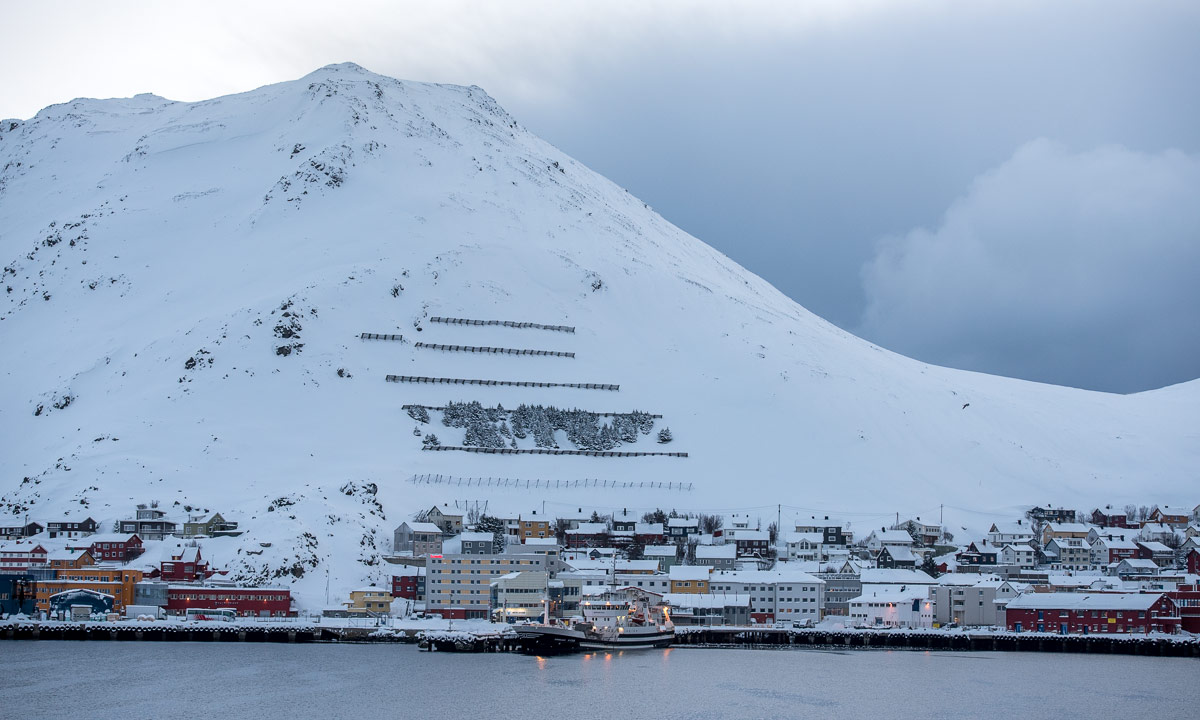
After the driveway was cleared, Trond invited the Dutch guests and us to a short private guided tour in Vardø. We entered his all-wheel drive car and he drove us the short way to Vardø – a town with 2100 inhabitants located on an island – where he showed us some of his favourite places. There is a lot of street art in Vardø and next time I have to take a closer look to all the graffiti and more conceptual artworks. But you cannot do all in a single journey.

There’s a mountain pass between Vardø and Ytre Kiberg called Domen. It’s quite exposed to the elements and when we crossed it waves of driving slow covered the road.

3. Yesterday, Skallelv – a short visit

Soon after we arrived in Kiberg, the Dutch guests left and Annika and I made a car ride to Skallelv, 30 km south of Ytre Kiberg. The weather was really nice: sunny and hardly any wind. We went round a bit and I made some photos. I had however problems with some lenses, they got moisture inside that tends to freeze when being outside. Hopefully they will dry within the next days.

4. Yesterday, Vardø – the Vardøhus Fortress

After a rest we took a tour to Vardø again, this time we wanted to focus on two local attractions: The fortress and the witch memorial.

The Vardøhus Fortress (Vardøhus festning) was built round 1300 and is the northernmost fortress of the world. Beside of being a museum it is used today as a school for the Norwegian marine. Shortly after we arrived there, the Trollfjord, a Hurtigruten ship landed in Vardø and shortly after many tourist rushed through the fortress. In contrary to us they only had litte time.

5. Yesterday, Vardø – Steilneset Memorial

After visiting the fortress we went on to visit the witch memorial. It’s not easy to reach. First of all you have to know that it is called Steilneset Memorial (or find it visually), then you have to plunge through deep snow, because there are no cleared ways to the memorial.

In 1621 91 people, mostly women and Sami people had been executed for witchcraft. This memorial, created in 2011, shows the history of all 91 people and lists the confessions made. It is a shocking and touching place about the cruelty of mankind and worth to visit, if you are in Vardø and have the time.

After this long and eventful day we were quite exhausted and decided to take it a bit more easy the next day.

6. Today, Ytre Kiberg – a promenade in Ytre Kiberg

Today morning it was quite warm (-4 °C) and almost windless. 10 cm of new snow had been fallen over night. After breakfast we took a medium short promenade along the beach and into the village and back. The weather was changeable as it uses to be here. It could change from sun to snow within less than a minute.

Snow fall intensified and it became a bit windier, too.

7. Today, Ytre Kiberg – a private tour though the partisan museum

At 15:30 we had an appointment: we were invited to visit the Partisanmuseet – the partisan museum in Ytre Kiberg. We would get a personal guided tour from Steinar Borch Jensen – expert for the history of Kiberg and around – who would open the museum for us.

Trond took a huge spade, we entered the car, drove the short way to the museum, plunged through the snow to the entrance, where Steinar already had started to clear the outer stairs. Trond joined him shovelling.

The museum is not the biggest and the showpieces maybe not the most special, it’s the stories behind the showpieces that matter. Steinar had a lot to tell about the partisans in Northern Norway that fought on the Soviets side against the National Socialists in World War II. Beside of Steinar’s huge knowledge about that time there was another facet, that made our visit in the museum very special. Both Trond and Steinar have personal relations to the partisans. They know their relatives and they know the places where they lived. For many Norwegians the history of WWII is not just an academic interest but personal history. Soon the last witnesses of the past will be gone.

I felt very touched by the visit and was glad that we got the opportunity to get involved into the local history, but it made me thoughtful, too and reinforced my personal pacifistic worldview.

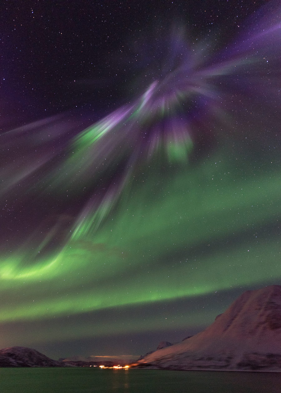
8 .Today, Ytre Kiberg – the first Varanger polar lights

Actually I planned only seven stories in this long blog article, but well …

I was out after a great two course dinner: reindeer (provided by Trond), pancakes (provided by Annika) and me doing the dishes. I wanted to make a photo of Cape East Arctic Adventure, Trond’s house, where Annika and I had such a good time. Then I spotted faint polar lights. I wore only a t-shirt and got in to fetch my Canada Goose parka. I was outside quite a while since the polar lights gradually became stronger. They constantly changed place making it hard to take any good pictures. It was -10 °C, quite windy and more and more I closed the zipper of the parka to prevent freezing. After a while the aurora weakened and I went in to look at the photos. I’m not content with the image above, but it’s a nice remembrance of our fantastic stay at Cape East Arctic Adventure in Ytre Kiberg.

Tomorrow we will leave and stay in Ekkerøy for some days.

Tusen takk, Trond, for your kindness and your great hospitality!

Ekkerøy and Nesseby

This article is part of the series “2018-03: Varanger peninsula”.

Day 34 and 35 of my winter journey 2018

After some days in Ytre Kiberg Annika and I travelled to the next place: Ekkerøy. This village, 50 km southwest from Kiberg lies on the peninsula Ekkerøya that is connected to land by a natural dam with sandy beaches on each side. We already had taken a short walk at one of the beaches last week, where we had met H., one of the locals.

We arrived in Ekkerøy three days ago. The day before yesterday I took a morning promenade with my camera. I made some photos, but the light was a bit dull.

After breakfast Annika and I started a tour round the island, partly with snowshoes, partly on foot. There’s a cliff at the southern shore that looks quite impressive. At the eastern tip there’s an old wooden sea mark. The northern shore is quite flat and was more snowy. Outgoing tide already had started so we walked the last meters on the beach until we came to our wonderful house, that we’ve rented for four days.

As you might have noticed almost all photos shown in this blog have a landscape format. I have a project however that might involve having portrait format photos as well. Therefore I walked to the beach yesterday morning to find a motif fitting portrait format, not too easy in a landscape that’s extensive and mainly quite flat. It was almost high tide and it was quite cold – -12 °C and very windy. The water at the beach was almost of a slushy consistency and each wave flushed new liquid slush to the beach where it froze to a wavy line of ice. That motif went quite well in portrait format, I just have to practise my view.

(I have to think over the design of my blog, these portrait format images are way too large.)

It cleared up more and more and the sun shone from a blue sky. We took the car to Nesseby, 50 km away, where I planned to make some photos of the Nesseby Church. The more we came to the more sheltered parts of the fjord, the colder it got and the open water of the Barents Sea smoked. This phenomenon is called sea smoke and happens, when cold air lies over the open sea.

From the harbour Nesseby Church could be seen through the foggy sea smoke. It is located quite exposed at the thinnest part of a peninsula and can be spotted from long, when weather is good. After looking from the harbour we continued to the church and had a closer look.

We took a short detour to Varangerbotn. There it was even colder with -19 °C but fair weather and hardly any wind.

It’s fascinating to have a look at the fjord of the same name. At the end it’s completely frozen with many icy humps, but on the way back (and north again) it opened and sea smoke appeared again.

In Vadsø I took a promenade on the island Vadsøya to have a look at the airship mast. Since I’ve been a child I’m a huge fan of balloons and airships and it was interesting to see this mast, built in 1926 and only used twice: by Umberto Nobile and Roald Amundsen for their expedition over the North Pole with the airship Norge in the same year and on Nobile’s flight with the airship Italia two years later.

Home again we remembered that H. who we’d met the week before had asked us in for coffee some day. At 4 o’clock we knocked at the door of her house and met her husband T. who directly invited us to come in. H. was visiting a friend and would join us later. We talked and talked, about languages, life in Northern Norway in general and Ekkerøy in special and we had a good time (and got coffee, cakes, cheese, grapes and red wine). When we left H. and T. – two of the round twenty permanent residents in Ekkerøy – it was already 9 pm and sky was dark … beside of a beautiful aurora dancing above the northern shore.

It took some minutes to walk home, put on warmer clothes, get camera and tripod and the aurora already had weakened a lot when I took the photo below. So it is with northern lights: intensity can change very fast, often within seconds.

Today we have another day in Ekkerøy. Our plans so far: not any. That’s nice, too!


A skitour near Ekkerøy

This article is part of the series “2018-03: Varanger peninsula”.

Day 36 of my winter journey 2018

locking the rented house in Ekkerøy – taking by car to the main road – looking for a parking place – mounting the skis – following the snowmobile trail – leaving that trail – slowly ascending the hill – leaving the last willow bushes behind – skiing – breathing – viewing – enjoying Varanger’s “kalfjell” above the treeline.

Farewell Ekkerøy

This article is part of the series “2018-03: Varanger peninsula”.

Day 37 of my winter journey 2018

Today we bade Ekkerøy farewell. When I woke up this morning, 5 cm of fluffy snow had fallen and covered everything except the road that already had been cleared of snow. On the beach however ice and the new snow still were present.

After breakfast we packed the car and cleaned the house Skjeldrum, that we had hired for four nights. We said goodbye to L. from whom we rented the house and left the village Ekkerøy behind.

We took the E 75 southwards: KibyVadsøVestre JakobselvNessebyVarangerbotn. Tomorrow we will head to Berlevåg, today we stay in Seida near Tana, which is already on the way.

But before that we made a detour: We took the E 6 to Byluft to visit Helmer Losoa and his incredible Sea Sami Collections. We’ve been there last year and were looking forward to meet Helmer and visit this museum again.

To the article about the Sea Sami Collections.


The Sea Sami Collections in Byluft

This article is part of the series “2018-03: Varanger peninsula”.

Day 37 of my winter journey 2018

When we left Kirkenes last year we got the tip to visit the Sjøsamiske samlinger – the Sea Sami Collections in Byluft. We went there and were amazed at the huge collection of showpieces. This year we visited the museum again, this time with more time and a warmer winter jacket, since the exhibition rooms are not heated.

Helmer Losoa, who runs the museum gave us a warm welcome and asked us in to coffee, where he talked about the museum’s and his personal history.

Helmer was born and grew up in Byluft. Aged 15 he went to sea on the training ship M/S Gann. That was in the ’50s. He travelled for many years and lived in Oslo a long time. When he moved back to Byluft in 1990 much had changed. Everything was motorised and many things were made of plastic. Helmer wondered what had happened to the old things of the Sea Sami in this region and started to collect many items, mostly from the years 1830 – 1950. He got support for building the museum but not for running it. A part of the items were donated to the collections, but most things Helmer bought himself from his own money.

After drinking coffee and listening to Helmer we went to the museum and Helmer showed us around.

There are many facets that make the Sea Sami Collections especially interesting:

  • While many other museums focus on the Mountain Sami who herded reindeers, this museum focuses on the more unknown Sea Sami who lived by the Norwegian coast of fishing, farming and hunting.
  • The exhibition is huge! I guess you could build at least ten new museums all over Northern Norway from all the exhibits that Helmer collected under the last 28 years.
  • Helmer can tell many stories about the showpieces in his collection. Some of them belonged to his relatives and he knows a lot about the history behind.
  • There are no glass boxes. You can have a close look at everything and with Helmer’s permission you are allowed to touch some of the items.
  • The museum reflects the everyday life of the Sea Sami in older times. Beside of wooden boats or fishing equipment you will find old coffeepots or radios, too.

We stayed in the museum quite a long time. It probably would take weeks to look at all the showpieces in detail. We looked around, asked questions to Helmer and listened to his stories. After some time we left the museum and said goodbye to Helmer.

Thank you so very much, Helmer! It was a pleasure to meet you again and to be guided through your Sea Sami Collections. Hopefully we’ll meet again sometime.

The Sea Sami Collections are located in Byluft, 29 km east from Varangerbotn.

Over the kalfjell to Berlevåg

This article is part of the series “2018-03: Varanger peninsula”.

Day 38 of my winter journey 2018

The Varanger Peninsula has many inhabited places at the coast, but you cannot take the car and drive around the whole island, not even in summer. There are three roads:

  • The E 75 to Vardø via Vadsø. In summer you can continue to Hamningberg, but this place has been depopulated since 1964 though some houses are used as summer cottages.
  • The 890 to Berlevåg via Kongsfjord. In summer you can continue to Store Molvik, but there are only summer cottages.
  • The 890 and 891 to Båtsfjord.

We explored the towns connected by the E 75 so far. Yesterday however we left the Varanger Peninsula, visited the Sea Sami Collections in Byluft and spent the night in Seida near Tana. Today we continued our trip and entered the Varanger Peninsula again, this time using the 890 to Berlevåg.

A local in Ekkerøy had warned us about this road, which leads about the kalfjell – the bare mountains above the treeline. The weather conditions can be severe and the road can be closed anytime due to bad weather or only accessible by kolonnekjøring, which means that you drive in a guided convoy led by a snowplough. Mostly it’s not snow that is the problem, but strong winds, that can create impassable snowdrifts within minutes.

The weather today however was fine and we didn’t have any difficulties in crossing the kalfjell. The road is really exposed to the elements and I can imagine that the very same road will be completely impassable in stormy conditions.

There is however another possibility to travel from one place to another: using the Hurtigruten ships, that connect Berlevåg, Båtsfjord, Vardø and Vadsø on their way from Bergen to Kirkenes.

Hurtigruten in Berlevåg

This article is part of the series “2018-03: Varanger peninsula”.

Day 38 of my winter journey 2018

Annika and I travelled a lot over the Varanger Peninsula the last ten days and we only saw one Hurtigruten ship far away. Tonight we stay in Kjølnes, just six kilometres outside from Berlevåg. So we took the opportunity and looked at the incoming Hurtigruten ships at the port. The north going and south going ships meet outside of Berlevåg, today the Polarlys and the Vesterålen. Unfortunately the ships arrive at 21:45 and 22:00, so it was dark, when we stood at the edge of the breakwater to welcome (and photograph) the Hurtigruten ships.

In three days we’ll be in Berlevåg again, this time on the Hurtigruten ship MS Nordnorge, but that’s another story …


Stopover in Kongsfjord

This article is part of the series “2018-03: Varanger peninsula”.

Day 38 of my winter journey 2018

After our lonely drive over the kalfjell we approached the coast again. First we spotted small forests, then quite a lot of cabins and finally the Kongsfjorden. The landscape looked much wilder and rougher with steeper mountains and quite inaccessible coast lines than the eastern coast of the Varanger Peninsula, that we just left two days ago.

After some kilometres we approached the village Kongsfjord.

Although this village has hardly more than 30 inhabitants it has however a grocery, that acts as a museum and a café as well. After it had been closed for some time, the new owners had opened it last August and keep it open all the year.

We went round the small town a bit too but continued then to Kjølnes Fyr, 5 km before Berlevåg where we planned to stay for one or two nights. Some impressions of Kongsfjord’s harbour area in wintertime:

By the way: Now it’s two days later and Annika and I are actually sitting in the very same café in Kongsfjord while writing this blog article. We’re waiting, but that’s another story …


Kjølnes Fyr

This article is part of the series “2018-03: Varanger peninsula”.

Days 38 to 40 of my winter journey 2018

Saturday

After our stopover in Kongsfjord we continued the road 890 in direction Berlevåg. The road follows the coastal line of first the fjord Kongsfjorden and then the open Barents Sea. Our destination for today is Kjølnes Fyr where we planned to stay over for one or two nights.

Kjølnes Fyr is located on a small headland called Kjølneset 5 km east from Berlevåg. We had booked a two-bed room at this place because it looked more interesting than the “large” city Berlevåg with its round thousand inhabitants. At half past one we arrived.

I directly fell in love with this place. The lighthouse – some other houses around – a rugged rocky coast, partly covered with snow, partly with seaweed – to the west bare mountains and to all other sides the open Barents Sea.

If you started a boat trip from Kjølnes Fyr heading north, the next land you would approach would be Kongsøya, part of Svalbard.

Viggo who operates the lodging gave us the key to the lighthouse and we took a closer look. The original lighthouse from 1916 was destroyed in World War II, the new lighthouse was built in 1949 and has a very functional and sober appearance. We went up and looked over the Barents Sea watching the high waves breaking at the rocky shore.

Viggo and his wife moved to Kjølnes Fyr in last autumn. He has rented the houses, that are protected as a historic monument. He told us from a winter storm that he experienced in January. Wind speed was up to 70 m/s (~250 km/h) and the upper floor of their house was shaken so violently, that the vibrations moved around the furnitures inside. Compared to that experience we had it quite calm.

The only thing we made over daytime was driving to Berlevåg to buy food. In Norway almost all shops are closed on Sundays and there were things we needed (spaghetti …) and things we wanted (chocolate …).

Later that evening we drove to Berlevåg again to see the Hurtigruten ships coming in.

Sunday

Under the night the wind got a bit stronger and the waves approaching from the north had become higher. Annika and I took a really lazy day. I was outside several times, but only for taking photos of waves. They never broke at the same place twice and gave me a hard time making pictures.

Weather became worse the whole day: The wind increased more and more and it started to snow, which means that snow was thrown into my face vertically when I dared to look into the wind. When it started to get dark, the ice and snow covered rocks in the cold light of the blue hour made the landscape look as what is actually is: arctic.

Already in the afternoon the Norwegian Meteorologisk institute had issued a class one wind warning for the whole area. I started to get a bit nervous. The next day we wanted to continue to Båtsfjord, our last stay on our Varanger trip but I was not sure whether the weather would allow it. Anyway, all roads were still open.

Monday

It had snowed a lot in the night and still was snowing heavily. Due to the stormy wind parts of the ground were completely bare of snow while other parts were covered with knee deep snow. At the same time it was quite warm, hardly below zero. The weather warning was extended to the afternoon but wind should decrease a bit over the day, so we planned to start round 12 o’clock. I was out and took some more photos, but it was really rough weather, especially for the camera.

Right after breakfast Viggo got a call of another guest approaching from Berlevåg by car. She couldn’t find the departure to Kjølnes Fyr due to severe weather conditions and asked for help. He took the car and drove to the main road just to mark the departure visually. When she came in she looked quite exhausted from the short car trip. She advised us not to continue the trip that day and told us, that visibility was partly only 10 meters which would make it impossible to see the next way mark.

We waited some time but despite of the stormy wind the visibility looked really good. Therefore we decided to give it a try and drive at least to Kongsfjord, that we passed two days ago. Here we could either continue our trip or take a room and stay in Kongsfjord overnight.

So we packed the car, said goodbye, removed the snow from the car and started our car trip to Båtsfjord at 11 o’clock.


+++ breaking news +++ aurora on the Hurtigruten +++

Day 42 of my winter journey 2018

Just one hour ago: Aurora on the Hurtigruten ship MS Nordnorge just behind Skervøy, and what a nice one!

I was glad to find a place for me and my tripod because there were a lot of other travellers – mostly tourists – out and watched the northern lights. They made photos with any camera they had; from smart phone to DSLR camera with tripod.

I used ISO 1600, ƒ 1/2.8 and an exposure time of 4 seconds. To my surprise some of the photos were quite sharp although the ship was moving.

Why travelling in Northern Norway can take time

This article is part of the series “2018-03: Varanger peninsula”.

Day 40 of my winter journey 2018

At 11 o’clock we left Kjølnes Fyr and started our car trip to Båtsfjord. First we had to take the road 890 to Kongsfjord and over the Kongsfjordfjellet, then we had to continue on road 891 over the Båtsfjordfjellet to Båtsfjord.

I wasn’t sure if we would manage it due to the severe stormy and snowy weather. Another guest staying at Kjølnes Fyr had a hard time driving the 5 km from Berlevåg with very bad visibility. The roads however were still open though marked with a warning “difficult driving conditions because of snowstorm”.

And yes, it was stormy and it snowed a lot. The sight on the road however was still quite good. While I focussed on the road Annika took some photos of the coast beside of the road:

Some parts however were very hard to drive, since the visibility was extremely bad. It was hard to see whether there were snowdrifts on the road and how deep they were and several times I had to stop completely to find out, where the road continued.

I started to doubt if it was possible to cross the mountain passages but we would make it at least to Kongsfjord where we could stay overnight if continuing became impossible. Annika tried to check the traffic information of Vegvesen – the Norwegian Public Roads Administration – but there was no mobile internet available.

I continued driving along the E 890 and the only other vehicle we met was a snow plough. The street behind it however seemed as snowy as before.

Shortly before Kongsfjord Annika’s smartphone was online again and she informed me about the updated traffic information: The mountain sections of both the 890 and the 891 where restricted to kolonnekjøring which means that you cannot drive alone but have to follow a convoy guided by a snowplough. The kolonnekjøring was scheduled to 14:30. The good thing: Driving in a convoy would be much easier than driving alone.

When we arrived in Kongsfjord it was 12:10, so the 28 km drive from Kjølnes Fyr had taken more than an hour. We were lucky that there is a landhandel – a grocery – in Kungsfjord that is open all year. We entered the landhandel, told about the kolonnekjøring and were invited to coffee and cookies straightaway. A big thank you to the owner for the warm welcome!

While we sipped our coffee and waited we constantly checked the traffic informations. After a short while we learned that the start of the kolonnekjøring was postponed to 17:00. That meant more waiting, but we were not the only ones. Other men in work clothes – mostly fishermen – waited as well. They told stories, laughed out loudly while drinking coffee or eating fast food. Anyway we all were still lucky. While we only had to wait some more hours many other roads were completely closed due to the weather, among others the way to Mehamn, the passage between Kiberg and Vardø and the only way to the North Cape.

Hours later: We said goodbye, cleared the car of snow and drove the short way to the boom gate. Here some other vehicles, mostly trucks waited for the convoy to start. One of the truck drivers attached snow chains to his truck.

Dusk had already been falling when our convoy started some minutes after 5 o’clock. My job for the next time was following the rear lights of the car in front.

Some passages were quite easy to drive, some passages were hard to follow due to the blowing and driving snow. (Sorry, no photos.) After 35 minutes we arrived at the T-junction, where the 890 from Kongsfjord, the 890 from Tana Bru in the south and the 891 from Båtsfjord meet. A long queue of cars coming from Tana Bru already waited. Some minutes later the convoy from Båtsfjord arrived as well. The snowplough leading the convoy to Kongsfjord passed and seconds later our queue of cars started to approach the intersection were we turned left to follow the convoy to Båtsfjord.

This part of the trip was extremely exhausting. It was dark, the convoy was slow and mostly the visibility was really bad. I just tried to follow the red lights in front and it felt like hours and hours until the snowplough turned right and we suddenly arrived in Båtsfjord. Here it seemed to snow as much as in the mountains and I was very relieved when I finally parked the car at our overnight stay. Phew – that was no easy ride and I’m really grateful that convoys led us over the mountains under the snowstorm conditions.

The rest of the day? Buying foodstuff at REMA 1000, eating fast food, falling asleep quite fast while the snow squalls over Båtsfjord continued. According to our host 30 cm of snow already had fallen that day and more was expected.

At least we arrived in Båtsfjord, probably our last overnight stay on land. The next evening we would take the Hurtigruten to Ørnes, were we would drive home to Skelleftehamn and Umeå.

(The first five photos were shot by Annika. I did the editing.)

Back home again

Day 44 of my winter journey 2018

Ok folks, I’m tired, let’s keep it short and simple:

 ►►► I hereby declare the winter trip 2018 over.

After a long car ride starting in Ørnes Annika and I arrived in Skelleftehamn at 5 pm and I’m home again.

The part through Norway took a long time as usual because of the road bending and twisting left and right, up and down. The part through Sweden was much faster, but a bit of a bore, since there is not so much to see beside of snowy forests (ok, there is more to see, but not if you just want to come home).

We had blue sky the whole journey and temperatures between -5 °C and -20 °C.

In Skelleftehamn there’s still a lot of snow and the fence in the backyard is snowed under. Just now (19:57) the sky is clear in Skelleftehamn and the temperature is -13.6 °C. No polar lights (yet).

Some random useless facts about the journey:

  • 3798 kilometres by car
  • 59 hours by Hurtigruten
  • 4 different countries
  • -34 °C coldest temperature (and -25.8 °C home in Skelleftehamn)
  • only 1 day with rain and degrees above zero
  • overnight stays at 18 different places (if I counted right)

Some missing blog articles that I’ll write the next days:

That’s all for today,
/Olaf


A day in Båtsfjord

This article is part of the series “2018-03: Varanger peninsula”.

Day 41 of my winter journey 2018

After a difficult car ride over through gale and snow Annika and I arrived in Båtsfjord, where we stayed overnight.

As usual I woke up early. I got out of bed and took a first look at this town. Although a lot of snow had come the day before all roads and streets were already cleared. Some houses and fences however were still snowed in. Perhaps the houses were not in use or the owner was travelling, too.

And here a look at one of the harbours.

After breakfast Annika and I got a guided tour through Båtsfjord by our landlord. He comes from Finland and came to this town in 1999. He showed us round and told us a lot about this town whose main economical sector still is fishing. The fishing port is one of the biggest in the Finnmark with around 10000 boat arrivals per year.

He drove us to a place at the harbour where you can watch two species: (1) the king eider, a large sea duck and (2) the bird-watcher, a subspecies of the human being. Four of these bird-watchers lay in a huge box in the water and were spotting the king eiders. Mostly you couldn’t see the bird-watchers themselves but only their huge tele lenses.

Thank you, landlord from Finland whose name I forgot for this interesting guided tour!

Some other images of Båtsfjord I made over the day:

Later that day we sat in the waiting room and waited for the Hurtigruten to come. Our two-week stay on the Varanger Peninsula would end today and we slowly would travel home again. But instead of directly heading home by car (943 km) we would take the Hurtigruten ship to Ørnes and drive home there. Well, that spares us only 360 km and takes almost 60 hours, but it’s nice to travel by Hurtigruten, especially after visiting so many different places by car.

At 19:45 the Hurtigruten ship MS Nordnorge arrived and the next stage of the journey began.


Båtsfjord – Ørnes by Hurtigruten

This article is part of the series “2018-03: Varanger peninsula”.

Days 41 to 44 of my winter journey 2018

13 March at 19:45 the Hurtigruten ship MS Nordnorge docked in Båtsfjord. Annika went on board with all our luggage that we would need the next days, while I drove the car into the elevator. The next 59 hours we would travel many miles but stay in the same cabin. Cabin number 305. Kind of luxury. We would even get breakfast because of a campaign. On 16 March round 7:00 we would leave the ship in Ørnes and drive home.

I will not write much about this part of the winter journey but showing photos from the Hurtigruten trip with some comments.

13 March 20:30 – finally on the Hurtigruten. Shop, reception, restaurant and people cruising.

13 March 22:00 Berlevåg – the westernmost of the four Hurtigruten stops Vadsø, Vardø, Båtsfjord and Berlevåg. Some days ago we stood on the breakwater to see the ships coming in, now I stand outside on the bow of the ship to see the very same breakwater passing as we approached the peer.

14 March 05:25 – very early and quite cold in the wind. I’m the only one outside beside of people working.

14 March 05:40 – approaching Honningsvåg on the island Magerøya. Main attraction of that island: the North Cape.

14 March 06:35 – I stay outside and look at the constantly changing weather.

14 March 08:25 – two ships pass. First a smaller boat, twenty minutes later the Hurtigruten ship Kong Harald. It’s snowing.

14 March 11:15 – we approach Hammerfest. Normally the ship will lie there for two hours, but today the ship is late.

14 March 15:45 – I’m outside for some hours and enjoy the view at the landscape. Everything is constantly changing: The mountains, the perspective, the light.

14 March 20:15 – strong polar lights cover the sky. Many people are outside and so are we. I already showed some photos in the article Aurora on the Hurtigruten.

14 March 23:45 – we approach Tromsø. Annika and I are already in our cabin and ready for sleep, but I can see the Tromsø Cathedral through our porthole. (We booked a cabin with limited view to save money and our porthole is more like a tube.)

15 March 07:30 – it’s not cold but very windy on the bow of the ship. My advise for such a winter journey: take the warmest jacket you have.

15 March 07:35 – we approach Harstad.

15 March 10:20 – we reach Risøyrenna – the Risøy Channel, build between 1911 and 1922 to enable bigger ships pass between the islands Andøya and Hinnøya. Only seven meters deep.

15 March 17:00 – we approach the quite famous Trollfjord. In winter however the Hurtigruten ships do not enter it.

15 March 18:30 – we arrive in Svolvær, largest town on the Lofoten. It’s a longer stop and Annika and I leave the boat for looking around.

16 March 06:00 – the alarm clock rings. At 7 o’clock we will arrive in Ørnes, leave the ferry and drive to Skelleftehamn. 583 km by car then I’ll be home again after more than six weeks of travelling.

A ski tour in the Kvikkjokk mountains – day 7 to 9

This article is part of the series “2018-02: Ski tour near Kvikkjokk”.

Day 13 to 15 of my winter journey 2018

(finally the last part about Jonas’ and my ski tour five weeks ago)

Tuesday, 13 February

I woke up in the cabin Tarrekaisestuga at 7:20. Some more centimetres of fluffy snow had fallen over night and it was still snowing slightly.

While Jonas and I had breakfast the snowfall intensified so that the mountains and the opposite shore of the lake Darrávrre were hidden by the falling snowflakes. Even the deep tracks of our pulkas from the day before had been snowed over and we couldn’t spot them anymore. We planned to gradually walk back on the other side of the lake and find a tenting place there. After breakfast we packed our equipment into the pulkas, cleaned up the cabin and started our tour by crossing the lake. It was still snowing quite heavily and on the lake it was quite windy, too.

It was not easy to find a path on the other side of the lake. The snow was soft and deep, some parts were forested quite densely and some passages were quite steep. At least for me, who lacked both power and general fitness for dragging a heavy pulka uphill through this sort of powdery snow where you sink in 20 to 40 cm with every step – with skis on!

Slowly and with many small detours we managed to ascent the southern hills until we reached the treeline where the terrain is more open and less hilly. We found a boulder where we found shelter against the wind. Here we took a snack: Chocolate, trail mix and hot tea.

We continue skiing slowly going uphill heading east. It stopped snowing and the wind dropped but the weather was still grey and dull. At least we could see the mountains again.

Suddenly we came to an abrupt stop. We stood at the edge of a deep, steep ravine impossible to cross. Such can happen if you do not make a detailed tour planning but just have a general idea of where to go.

After a while we started to look for a place to tent. First we followed the ravine that the river Áhkalmgårttje had cut into the landscape then we descended a bit to find a sheltered place between some birch trees. The snow was really deep and without skiers I sank up to my stomach into the fluffy snow.

Fortunately the snow was stable enough to build up the tent after we had trampling down it thoroughly with our skis.

Later in the evening: I wonder, why it is never completely dark. Is it still lights of civilisation reflected by the clouds? Suddenly something was flickering between the clouds. Is it a strong aurora? No, it’s just too vivid. But what is it? It was two snow mobiles that illuminated half the mountain landscape with their strong full beams. Slowly they passed on the lake below us.

Temperatures were round -10 °C, quite warm for a February night in the Kvikkjokk mountains. Soon I fell asleep.

Wednesday, 14 February

As usual I was awake quite early and I had a challenge: going on the loo. I just slipped into my warm mukluk boots, put on the down jacket and took toilet paper plus snow shovel with me. I went back on our track from our day before thinking it would bear my weight. It went well a few steps then I just fell through the snow and stood there, again up to my stomach in powder snow. This plan didn’t went so well. I climbed out of the hole, brushed off the snow of my long johns and looked for a better place. (I found it.)

This morning was even warmer with only -8 °C and quite foggy. Both wide angle lenses were completely fogged and it would take most of the day until I could make clear photos again. That’s what the morning  looked like:

As usual we took it easy and started only at 11 o’clock. We descended through the hilly open woodland until we met the winter trail. Snowmobiles had used this trail not long ago and now it was quite easy – even if a bit boring – to get ahead. And after some time even the sun tried to twinkle between the clouds. The first time after many cloudy days we casted shadows again. And it was snowing at the same time.

I skied fast on the snowmobile trail where I could use cross country skiing techniques. Too fast for Jonas and too fast for myself, too. I couldn’t hold the tempo and after some time I was really exhausted – not for the first time on this tour. On the other side it was already afternoon and we were already quite near Kvikkjokk, where I had parked the car. Jonas found a nice clearing in the forest were we tented the last time on this tour. And even the sky cleared up a bit.

Thursday, 15 February

We do not know if we missed northern lights while we slept. The morning however the sky was grey and overcast again and half a centimetre of dust-like snow covered the tent. (And my green anorak that I had forgot to put into the pulka.) Today we would have it easy. Just some kilometres skiing on the winter trail that means, following the snowmobile tracks, mostly on the river.

We passed the place where we had left the very same river the very first afternoon to find our tenting place. Here, in the “valley” much less snow had fallen and our deep tracks climbing up the steep riverside were still visible. Now it wasn’t long to the private shortcut that we had used on our tour start. When we came to this place, a snowmobile approached from that very shortcut, a man waved at us and made a turn to talk to us. It was Björn, the very same local that we met when we started our tour! He was quite eager to hear about our experiences even though he was a bit in a hurry. He also told us about two other Germans that he just had met at the very same parking place where I had parked my car.

The last kilometres, crossing a small frozen river …

… following the shortcut (which is quite long for being a shortcut) and finally we arrived at the parking place. We hadn’t much luck with the weather, we didn’t ski long distances, but it was an awesome tour anyway. Thank you, Jonas!

Plans for the next ski tour:

  • be better trained and exercised (!!!)
  • have less equipment (!!)
  • have (partly) better equipment (!)

Photo #6 and #9 in this blog article are made by Jonas Balbasus.

At the parking place we met Dan and Helen, also from Germany, who just were on the point of starting a much longer tour within less than two weeks: Following the Padjelanta, crossing the Sarek, returning on the Kungsleden. A very ambitious tour in my opinion. But they made it as you can read in Helen’s blog:
Winter ski tour through Sarek National Park – Sápmi / Swedish Lapland


Beginning of spring 2018

According to the meteorologists spring already had started on 1 March. They love to calculate in whole months. Astronomically the beginning of spring is just today.

Well, kind of …

Today I didn’t work but enjoyed the marvellous weather. Bright blue sky and sun, a good day to go to the beach.

Well kind of …

The temperatures were between -10 °C and -5 °C and the Baltic Sea is still covered with a thick layer of ice up to the horizon. Sometimes it’s solid ice, sometimes it’s packed ice. No open water is in sight and therefore no sea birds neither. Just snow and ice and the blue sky.

I left the mainland at the boat harbour Tjuvkistan and crossed the ice to the islands Norrskär and Bredskär. Now I walk along the eastern shore of Bredskär and then to the island Gråsidan.

At the eastern shore there’s a long wall of ice, up to two meters high.

I walk along the shore and look at the fantastical landscape of ice and snow. Sometimes I feel like being in an open air museum. I call the exhibitions “below zero, above sea”. Here’s one of my favourite exhibits:

I go round half the island and then cross it. Although the snow feels solid – like that green floral foam used for flower arranging – I mostly sink knee deep into it. I walk back along the western shore and then cross the ice to the southern edge of Bredskär. The island has a ice wall at the eastern shore as well, partly up to four meters high. Where shall I go? Right beside of the ice wall there are snow drifts, knee deep or even deeper. A bit farther there’s water between the solid ice and the covering layer of snow. Good to have rubber boots.

I cannot decide for the best way to go. So I’m walking king of zig-zag, constantly watching the ice edge. Sometimes there’s a long line of icicles …

… and once there’s even a quite large ice cave. A pity that it will melt within the next weeks (or months?).

I continue my walk, sometimes plunging through deep snow, sometimes just walking on solid ice, sometimes breaking through the snow into water and slush (don’t worry, there’s always a thick layer of ice beneath). I cross the natural gravel bank between the islands Bredskär and Norrskär and talk the same way back to Tjuvkistan.

Today I walked only round seven kilometres, but it was good to be outside, breathing air, letting my eyes wander, catching some sun and the colours of the sky. At 12:30 I reach the car. It’s very warm in the sun and I’m dressed too warm, but the air temperature is still -5 °C. It’s a season between winter and spring which is called vårvinter – spring-winter. A suitable name.

And here comes my favourite picture of today’s exhibition-expedition. I call it “layers of ice”.

Side note: did you notice the huge rubber boots I’m wearing on the first photo? I bought them in Murmansk a month ago. They are made for ice fishing and they are lightweight, comfortable, very warm and of course waterproof. And they were quite cheap. The only drawback: They have spikes that do the opposite of what they are made for. Instead of improving the grip the spikes just slide on the ice making the boots incredibly slippery on ice. I have to check if I can remove the spikes.


Winter is not over

It has been snowing 5 cm since last night, the day temperatures are round -6 °C and the ski track in Skelleftehamn was prepared hours ago. Although I’ve been in quite a lazy mood today I took my cross-country skis (hardly used the last weeks) and skied for an hour.

Ah, that felt good!

Note to myself: be more outdoors, be it skiing, hiking, kayaking, cycling, tenting, that doesn’t matter. Just be more outdoors!

Mountain hares in the night

I woke up from a bad dream tonight and stood up to get something to drink. I peeked though the kitchen window, it was snowing. On the snow wall in front of the neighbours front yard I could see a large snowball. It was moving. What?! I looked again and saw a mountain hare sitting on top of the snow wall. I spotted even two other pairs of white ears behind the snow wall.

Luckily I still had the big telephoto lens on my camera, so I adjusted the ISO value to 256000 (!) and tried to make some photos of the hare. The best one:

It’s not raining on the photo, it’s snowing, but even with this extreme ISO value I had to expose ⅛ second.

Then I got my tripod to get better images but the mountain hare seemed to spot me through the window and all hares run away in a flash. But only to hide on the street behind the snow wall in my front yard. (We still have at least 85 cm of snow in Skelleftehamn.) Some minutes later I spotted two of the hares in the street again but only for seconds before they ran away once more, this time for good.

This hare is a mountain hare. In Sweden this species is called Skogshare (“forest hare”) while in Germany its name is Schneehase (“snow hare”).

Now I’ll continue to sleep …

#escapism – an icy camp site

Yesterday

Yesterday at 17:40 my tent was set up on a snowy plane near the sea ice where I planned to stay for the night.

The dinner was part luxury (a really cold coke), part pragmatism (some instant curry chicken of dubious consistency) and part necessity (chocolate!). After the dinner I walked along the shore, which was completely covered with ice and snow. First I walked on land, then on the sea ice. You may think, that a landscape that solely consists of snow and ice must be quite colourless, but no, when there’s light there are colours!

When I came back to my tent, it already had become dark and the almost full moon hovered over the tent. And that was my view from the tent, too: The moon, some stars, snow, ice and the icebound sea.

You might wonder, where I am. Good point, I’ll explain. Let’s go back half a day.

Yesterday I worked only half a day and was home early. I had a plan in my mind: as long as the sea ice is as thick as just now, why shouldn’t I ski over the Baltic Sea to the island Gåsören and spend the night there. I’ve done that in summer twice by kayak but never in wintertime. So I picked myself up, packed skis and pulka and took the car to the small harbour Tjuvkistan.

While the Baltic Sea was open one year ago it is still covered with thick ice this year. Instead of open water one can spot only a snow covered plane and some tracks – made by hare, a moose, another skier, but mostly by snowmobiles, the favourite winter vehicle of many locals. I however do not own such a snöskoter but prefer skiing anyway.

The linear distance between Tjuvkistan and  Gåsören is only 2,3 km and so I arrived at the island soon. In summer it’s hard to find a tenting place (I know only one), since almost the whole island is covered with stones and rocks. This winter however Gåsören is covered with at least 50 cm of snow and so it was easy to find a good place to tent. Scroll up to the first photo and you see it.

OK, back to the story …

At nine a clock it was quite dark and a layer of clouds approached. Good arguments for cuddling up in my warm down sleeping bag and go to sleep. Good night, world.

Today

At five a clock I woke up and felt fairly well rested. I got up for taking some photos. Although it’s already the end of March the nights can be quite chilly and I guess that we had temperatures round -10 °C. I put on more or less all clothes that I had with me and made some photos. The moon had wandered on its orbit to the west and hovered above Gåsören’s old lighthouse.

That photo looks like being shot at the dead of night, doesn’t it? So let’s turn around and look to the east:

It’s less than 8 minutes between the previous two images and it’s more the cardinal direction than the time difference that is responsible for the different light and colours. I walked around for two hours and was just happy to be there at that fantastic place that fantastic morning and to experience all these different kinds of ice and light.

I became hungry so I returned to the tent. or tried … . Just a photo of the lighthouses behind the ice. And another one of my camp site.

But now: finally breakfast. Water, crisp bread and cheese. That may not be the most exciting food, but I didn’t care, I enjoyed the  incredible view over the icebound Baltic Sea in winter.

After breakfast I walked around another time and took some more photos.

Another break. This time just pure luxury. Since I wasn’t in a hurry the tent was still set up. So I could cuddle up in my cozy sleeping bag again and took a long daytime nap. The temperature was still below zero but the sun was high up in the sky and warmed the tent. And there was even chocolate left. Just “gemütlich”!

When I woke up an hour later a layer of stratus clouds had approached and the light had become dull. A good time to pack anything back into the pulka, to put on my skis again and to start the “long” way home. Good bye, Gåsören. Next time when I visit you it will probably be with the kayak. I love winter, but paddling in summertime is great, too.

When I had arrived at the car after Jonas’ and my previous ski tour, it was in Kvikkjokk, 400 km from home. This time the car was parked less than 3 km from my house. I’ve been living in Skelleftehamn for many years now but still I’m happy about the beautifulness of it.

This article is the first one of the new series #escapism. It’s about being outdoors and leaving civilisation behind in excursions that take less than 24 hours. Everyone should have time for such!

My packing list (excerpt)

tent with snow pegs · inflatable camping mat · down sleeping back (a warm one!) · clothes for skiing · spare clothes · winter anorak · thermal pants · warm boots · woollen cap · 2 pairs of gloves · down west · skis with poles and boots · pulka with hip belt · water (both cool and hot) · food (a lot!) · knife · camping stove · matches · kitchen stuff · mobile phone · power bank · headlamp · sunglasses · thermometer (it broke) · compass · isdubbar (essential emergency equipment in case of breaking into the ice) · toilet paper · snow shovel · camera equipment · tripod · grand piano (just kidding)