Ice station one and polar bears

This article is part of the series “2024-08: Fram Strait cruise KPH”.

For days we wondered, will we ever have an ice station on this Fram Strait cruise in open water? But then at 14° 21′ W, 79° 02′ N we found a large ice floe to work on. Shortly after nine o’clock I finally was on the ice again!

But I wasn’t here to take snapshots but to fly drone and to take a lot of photos from above.

I had issues with the drone from the Polar Institute, so I fetched my private one. First I had to calibrate some sensors, especially the compass and then I put the drone into the air and made some photos to check the image exposure. Ok, looks pretty good.

Now I flew the drone in a rectangular zig-zag pattern. That’s a bit tricky, because the drone is positioned by GPS while the ice flow is drifting. Since I wasn’t sure if I covered every part of the ice station I flew a second round. The single photos look like these:

Before going on board I took a couple of photos on the ice.

On board I uploaded the photos first into my laptop and then into the program OpenDroneMap that would stitch the photos together and add geographical information. And then it was 11:30, lunch time!

After lunch I went up on the bridge on deck 8. Together with two others I was observing my segment checking for polar bears, cracks in the ice and weather. There were several polar bears around but all were further away. I also had a VHF to keep track on the people on the ice. I had two shifts, 12:30–13:15 and 14:00–14:45.

After my second shift I got to know that we had a polar bear in front of the ship. So one of the bears that we had observed for hours had finally decided to pay us a visit. That meant of course that all people had to leave the ice.  On the helicopter deck many people were around to watch the bear.

And there it was – a surprisingly white curious fellow that examined our ship. Did it smell the cake?

In the meanwhile OpenDroneMap finally created a properly rendered orthophoto. I was relieved because I was not sure if my drone photos were sufficient. This is an excerpt:

In the afternoon I had fixed the issue with the other drone. At 19:00 I would have another opportunity to go onto the ice to re-calibrate and test it. Our ice visit was however postponed because another polar bear was paying a visit. It looked much thinner than the other one, but on the other side the fur was wet. So photo shooting again. It surrounded the ship and then stopped, laid down onto its stomach, pushed itself forward with its furry feet and  then rolled in the snow before it continued its walk.

We had to wait some time but then the ice was clear and I had time to test the drone on the ice. It worked. Hopefully I would be able to use it on the second ice station on the next day but the forecast does not look promising. Too much wind.

I shot a drone selfie and then I was ready to go on board. I just had to put my hand into one of the polar bear paw prints for size comparison.

The bear won!

5 × 5 images from a Hurtigruten cruise

Two weeks ago I took the plane from Tromsø to Bergen. From there I would travel back to Tromsø by Hurtigruten together with my sister, my brother-in-law and my mother. My wife Annika would join us in Trondheim two days later.

22 May

There is still a lot of snow in the mountains on Tromsøya, Kvaløya, Senja and other islands I do not recognise from the plane. But in the lowland it is springtime.

I travelled with the Hurtigruten several times, but never south from Trondheim. We were not the only one’s boarding in Bergen. A lot of people use the Hurtigruten as a cruise ship, not as a possibility to travel from A to B. And there it lies, the vessel Kong Harald.

We have boarded round 18:00. At 20:30 we are departing and leave the town Bergen behind.

We are in sheltered waters and you hardly notice the ship moving beside of the motor’s vibrations. Even though Bergen is nine degrees south from Tromsø is does not get dark anymore.

The weather is cloudy but when the sun peeks through a holes in the clouds it looks beautiful.

23 May

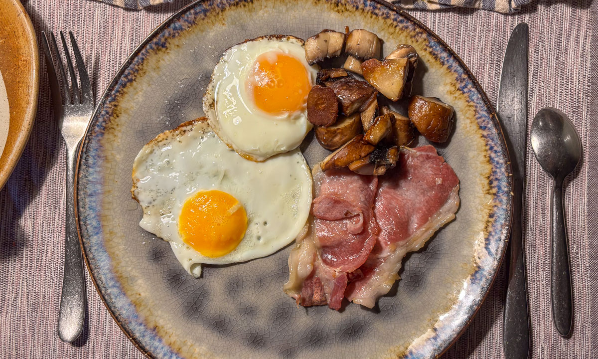
One breakfast later: We arrive in Ålesund where the Hurtigruten will stay for ten hours. Time to explore this town which looks so different from the towns in the north. Ålesund has many Art Nouveau houses and “exotic” plants like azaleas are blooming everywhere. Together with my sister I climb the four hundred and something steps up the Aksla where we have an awesome view on the town.

We have also a view on the cruise ship AIDA prima. And beside of that – our Hurtigruten ship Kong Harald. It looks so tiny in comparison. I definitely prefer the small one.

I take a short stroll through town before I meet the others. First I admire all the small Art Nouveau details on the houses, then I almost get a culture shock when I find this tunnel:

In the evening we circumnavigate the island Hessa, because the ship is “reparked” on the other side of Ålesund. After a very warm and sunny day clouds have been gathering. But the sun manages to send beams through the clouds.

Is this one of the life boats? I mean – a photo of one of the life boats? No, it is a photo of a reflection of one of the life boats. It is reflected in the glass facade of an office building by the port.

24 May

Where are we? In Trondheim. Yay! I was so looking forward to meet Annika there. She checks in, then we take a short stroll in town along the channel with the groundbreaking name Kanalen – the channel.

As in Tromsø there are Kittiwakes in Trondheim. They use to screech a lot – often to each other – but these two fellows seem to be a bit shy, at least in the minute where I took the photo.

At lunchtime we leave Trondheim behind. The shimmering sunlight is reflected by zillions of tiny waves. We meet commercial ships, fishing boats, two kayaks and sometimes a sailing boat.

On the port side there is the open sea. Blue sky, blue sea, a small skerry and a house. Wait, a house? Yes, it is erected on a floating raft. What you cannot see – it is part of one of the countless salmon farms located in coastal Norway.

I have moved into Annika’s cabin. It has no regular window but two portholes. It is five to eleven in the evening and the sun peeks into our small but practical cabin.

And that’s the night where I get sick. That really wouldn’t have been necessary at all.

25 May

I am feeling ill and I sleep, I sleep and I sleep. I do not leave the cabin before 17:45 to take some photos while we are approaching the Lofoten islands. They look like mirages at the hazy horizon.

Round half past seven we are approaching Stamsund, passing rocky skerries and rocky mountains. Northern Norway, here we come!

At the harbour a graffito was sprayed or painted on the outer wall of the waiting room. Free high fives! For me however it was time to continue sleeping …

… but I got up at 23:15 again to see more from the Lofoten islands. Some of the mountains look like not being from this world.

The light got dim but it didn’t get dark. It’s the first day of midnight sun on the Lofoten. And it is almost midnight.

26 May

The reason for being up so late is that Kong Harald sails into the quite famous and very narrow fjord Trollfjorden. The landscape is impressive because the Hurtigruten is so near to land. – especially the mighty dark rock face in the north.

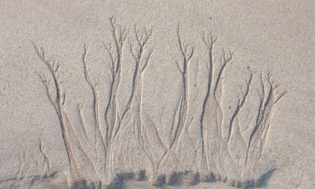
On our way back I spot a beautiful wave pattern. I really wonder how it was created.

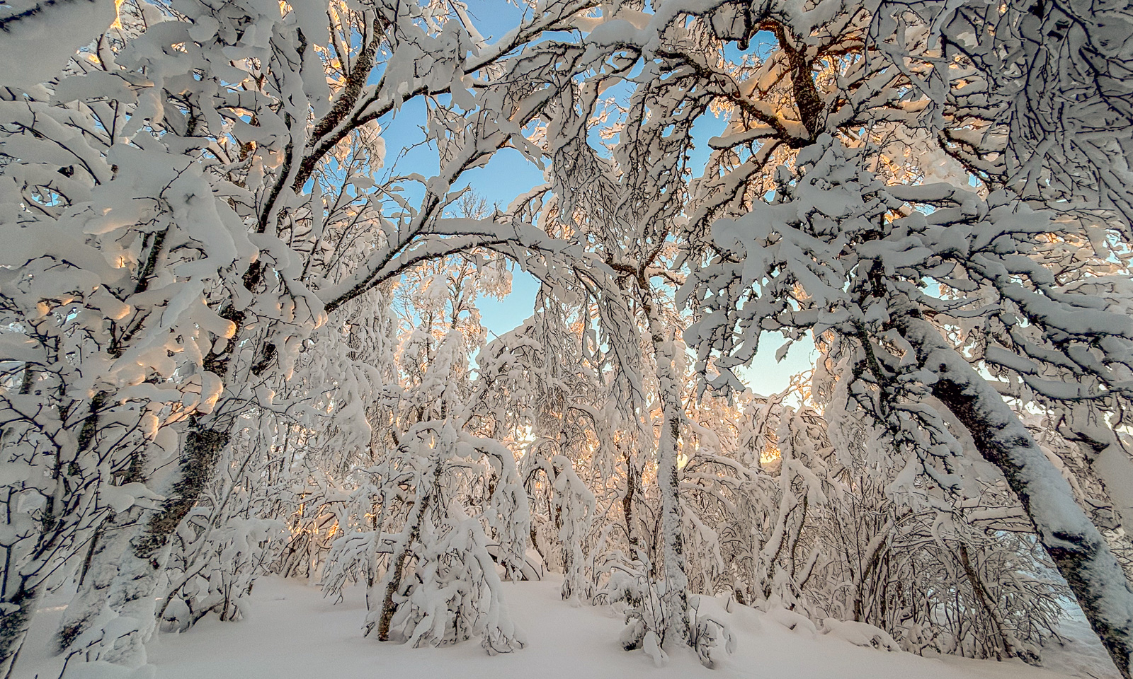
Then it is time for me to sleep. And I sleep long. At lunch time I take some more photos. Now the landscape looks very familiar. No wonder, in an hour we will be in Tromsø, where I’ve been working for three years now. To my relief there is still snow on the mountain tops. It looks so nice.

The sky is still blue and the sea has been calm more or less the whole journey. There is hardly any wind but the flag is flattering in the airstream.

Round two o’clock we pass the southern tip of the island Tromsøya and then the new buildings on the eastern sea side.

After round 93 hours we are leaving the ship. My family checks into their hotel, Annika and I take the bus to my apartment which has become on of my two homes.

Polarsyssel in Tromsø (and ice cream)

While I was sitting at my computer in my apartment in Tromsø I looked out of the window. A blue ship was sailing on the Sandnessundet, the strait between Tromsøya and Kvaløya. It looked somehow familiar. I checked, first with my spotting scope, then with an app. It was the Polarsyssel, the ship of the Governor of Svalbard. I managed to take a photo between the trees.

Last time when I saw this ship it was on 16 March 2023, the week I was working in Longyearbyen/Svalbard.

What does the ship do here so far south as in Tromsø? Chasing polar bears? I checked the news but couldn’t find anything. While I was watching the ship  my thoughts wandered north. In August I’ll be in the Arctic once more. Will I stand on the sea ice again? Will I see polar bears again?

Then I heard a melody outside:

This is a famous melody in Norway! It is called “Norge rundt” and is the signal of the Isbilen ice-cream vans. Today I was one of the customers. So I got my ice. And the brand of the ice cream? Isbjørn is – Polar bear ice.


Ski tour in Sweden – from Vistas to Lisas Stuga to Civilisation

This article is part of the series “2024-02: Ski tour Sweden”.

Day 12 – 9 March – Vistas—Lisas Stuga

Today is the last day of Annika’s and my ski tour. From Vistas we will follow the valley Visttasvággi to Nikkaluokta, where I have parked my car eleven days ago. We will however only ski part of it because the distance is round about 35 km. Too long for us on a single day.

After breakfast and cleaning we say farewell to our friend Dirk who is warden at Vistas for a month and follow the snowmobile track that turns left right after we have crossed the river. I’m glad that we can follow it since it crosses the river Visttasjohka many times and I feel saver to follow the track than to find our own way.

At one place there are two tracks in parallel. One track leads into an open patch of water, we wisely choose the other one.

We head to a small, old hut called Lisas Stuga. We were told that it lies by the scooter track and so we do not really have so seek it but just continue following the snowmobile track. After 11.7 km of skiing we arrive there at 12:30. We are half an hour early and so is the snowmobile driver that is here to fetch us.

We have never been here before and we take a look into Lisas Stuga which is tiny. The beds are definitely not my size at all.

Then we pack pulka, skis and Annika’s backpack on the back and hop ourselves into the front of the snowmobile trailer. Off we go. Although it is quite warm – perhaps round zero – it is nice to have the down parka to warm us, because the trip takes a while.

It is more than 20 kilometres and even if we had the fitness to ski this on a single day we think it would be pretty boring. The mountains get rounder, the valley broader and then there is a large lake to cross. And another one. And another one. Annika recognises a cabin by one of lakes and she is right. It is the last lake and we are there. Nikkaluokta.

While Annika pays for the snowmobile transport I check that my car is still there (it is). And then we enjoy the features of civilisation. And it’s not only about ordering lunch in a restaurant. It is also about washing your hands under running water. Hot running water. With soap! And dry them with paper towels.

Thank you Annika for a wonderful ski tour – our longest so far. I enjoyed every single hour.

Some days later …

I am back in Tromsø for work. It is the Friday after our ski tour. In the night it started snowing and round about five cm of new powder snow cover the street, where I live. That’s round about twice as much snow fall as we had on our whole ski tour ;-)

Now it is the week before Easter holidays. What will it bring? Rain and the first flowers? Or more snow?

Ski tour in Sweden – Singi—Sälka

This article is part of the series “2024-02: Ski tour Sweden”.

Tour day 3 + 4: 29 February – 1 March

Day 3 – 29 February – Singi—Sälka

Today is our second tour day. We will go north from Singi to Sälka. It is seven o’clock and beautiful out there. If the forecast is right that might change round noon where wind gusts of 16 m/s where expected.

This is why we decided to start early despite the short distance of 12 km. At 8:00 we leave Singi behind. The way is a bit hilly but relatively easy. We pass the Sami village Goržževuolli and then the bridge over the river Tjäktjajåkka. Here goes the summer trail to the cabin Hukejaure in the west. Not our destination today.

The weather is still nice, the sight perfect, navigating is simple. So we do not follow the winter road which lies to the right but just ski in the middle of the large U-shaped valley Tjäktjavagge. This leads to some confusion when we cross a winter trail marked with the traditional red crosses, but this is the snowmobile trail to Hukejaure, not the winter trail to Sälka which is not visible from here. The valley is broad and slightly hilly. We both can “climb” hills since we have skins under our skis but sometimes I go a detour when it gets too steep for pulling up the pulka.

When will Sälka come into sight? Behind the next hill? No. But the next one? No. Then the next? No.

At 11:30 it gets windy and snow is blowing above the ground. But first we have it in the back and then we are already quite close to Sälka and after another hill (we didn’t count) there there they are: the cabins of Sälka.

Sälka will be crowed tonight. 38 guests have pre-booked, amongst others two larger groups. We are extremely lucky to come early and to get the small two-bed room marked with a sign “private” at the door. Thanks a lot, warden Z.!

Now it has become quite windy. All other guest arrive from the north and are equipped with balaclava and ski goggles to cope the head wind.

The toilets at Sälka are 200 metres away. So take your down parka and a head torch with you if you go at night.

Night – Sälka

And yes, I was out to go the loo several times. But I like winter weather, so I do not complain. And then when I have to go again at three o’clock the sky has become clear and the first northern lights on our tour cover the starry sky. Beautiful, especially with the low hanging moon.

The first photo by the way shows the toilets.

Day 4 – 1 March – Sälka

Another resting day according plan. We have the luxury of having time for the tour that many others have to perform within a week.

A snowmobile has arrived. One of the groups had booked luggage transport. Here only the local Sami are allowed to drive snowmobile. We chat with the driver that shows us some of his reindeers that graze high up in the mountains. Do you see them on the photo below?

He also asks if we have seen wolverine tracks. These vicious animals kill reindeers as pray. But here and now a wolverine is around that attacks the animals without killing. Tome of them have a slow and cruel death. The Sami are not allowed to hunt wolverines due to species protection but they are allowed to scare them away. How the paw prints look like? “Like a fox on snowshoes.”

While he is telling us that either I or Annika are occupied by scratching the dog that cannot get enough of it.

Wolverines are endangered species and the biologists are interested in them. At the same time only the Sami are allowed to drive snowmobile in this part of the mountains. This leads to the curious situation that they collect wolverine droppings for the scientists, of course with proper metadata as time and location. Imagine you have a predator around threatening your flock and at the same time you collect its poo!

The rest of the day: Sawing logs and chopping some wood. Taking some photos. Early dinner to avoid the big group cooking at the same time. Sauna! Retreating to our room when the combined kitchen/living room is too crowded. Early bedtime.

Vacation.


Ski tour in Sweden – Kebnekaise—Singi

This article is part of the series “2024-02: Ski tour Sweden”.

Tour day 1 + 2: 27 February – 28 February

It has been four years since Annika and I went on a ski tour. In winter 2021 we didn’t travel because of Covid, in winter 2022 I joined an arctic expedition and in winter 2023 I worked on Svalbard and we went on vacation there. But now it is 2024 and finally we have the opportunity to go on a winter tour.

Prologue

On Sunday, 25. February I take the car from Tromsø to Kiruna. In the back of the car: My skis, all stuff for a two-week winter tour and a pulka. It has been a good choice to take the car because an ore train has derailed between Narvik and Abisko the day before and the railway line is closed (and will be until end of May).

On Monday Annika arrives by train. We buy some extra provisions for the tour such as salami, crisp bread and chocolate and then went to the hotel where we stay over night

On Tuesday we pack the car, take an early breakfast and then go off to Nikkaluokta, a Sami Village and our starting point for the tour. We would have skied the 19 km to the Kebnekaise Mountain Station but it is still closed. Luckily there is another way to get there …

Day 1 – 27 Feb – Nikkaluokta—Kebnekaise—Singi

The family business Sarri AB offers snowmobile transport to Kebnekaise. You can pre-book it. Soon we sit in the surprisingly comfortable trailer and are dragged to the start of the trail to Singi, our first tour destination. Our thick down jackets keep the frost outside.

From there it is 14 km to Singi. The weather is more than fair: blue sky, hardly any wind, frosty but not too cold. Annika is carrying a backpack, I am pulling a pulka.

We are skiing westwards. Beside of a moose and some crows we are alone. Clouds have gathered and the dull light made the mountains look sublime, unreachable and a bit hostile.

Head wind has come up and the sight has worsened a bit. Still we can see far, but the snow is harder to read. Is it hard? Or soft? Does it go up? Or down? It just looks white.

I’ve been here before in winter and I am waiting the cabins of Singi to come into view but it takes longer than expected. Anyhow we finally pass some ice fields …

… and then we can see Singi! After a while we arrive there and are greeted by one of the stugvärder – the wardens. We get hot juice and may choose a room, since there are only two other guests. The rest of the day is mostly eating and sleeping.

Day 2 – 28 Feb – Singi

We have tvelwe days in the Swedish mountains but only eight planned tour days. That leaves four break days, one of them being today.

The morning looks quite promising. Parts of the sky is clear again, parts are cloudy. Some of the clouds move through the valleys which can look quite dramatic.

After breakfast Annika and I take a small tour to the Sami village Goržževuolli (or Kårtjevuolle). On the way there we find an interesting paw print:

It is a paw print of a reindeer, but raised. When it went there it compacted the snow under its foot. Then wind came up and blew away the loose powder snow round the print but not the compacted one.

We pass Singi’s water hole. If you do not want to melt snow (tastes awful) you have to fetch water there. Singi is famous for having the water hole quite far away. If I remember correctly it is 800 metres away (and ca. 25 metres down). We are lucky, the other guests have already fetched a lot of water.

We continue to the village which is only inhabited occasionally. There are a lot of wooden cabins and sheds but there are also some traditional goahtis. Goahtis can be built from different materials, this one is probably built of peat moss and timber:

We look around, enjoy the sun and made a large turn to head back to “our” cabin. Later I am out again to take some photos.

In the evening Annika prepares dinner. While a lot of other people we will meet the next days use to eat “outdoor meals”, which is more or less quite expensive powder we have the luxury of having other food with us. It’s potatoes, feta cheese, onions and sweet peppers. Now fresh – too heavy, too bulky – but home-dried by Annika within the last weeks. Then with the help of fresh garlic, butter and vegan egg-powder (all in our provisions) Annika cooks a tasty frittata for dinner. I understand the point of light-weighted food but this stuff is so much better! Delicious! Tack för maten – Annika. Thanks for the food. Anyhow we can eat this kind of food only on our break days because the dried ingredients have to be covered with water for hours to rehydrate before being used.

After lunch Annika is reading, I am writing my travel diary then we head to our beds and fall fast asleep. Next day we will continue to Sälka, our next cabin.

Farewell Obbola

As almost every day the last weeks I went to the coast yesterday. This place is less than 100 metres away from Annika’s and my house in Obbola. It was partly cloudy but the upcoming sunrise made the clouds and ice extremely colourful. I waited for the sun to rise and then went back to my home office room to continue working.

Today I have other plans. After three weeks of being home – part vacation, part work – it it time to travel back to Tromsø. Normally I do this by train and bus, this time I travel by car. After I’ve found a nice flat in Tromsø I took my Norwegian car here to fetch some more stuff.

Such as a box of books, kitchen stuff, an uplighter, an Ivar bookshelf, my acoustic bass guitar, a bulky winter sleeping bag and more stuff that I want to have in Tromsø. Now my car is full but I still can use the rear-view mirror.

I guess I might need my down parka for if the weather forecast is correct it might be -25 °C on my way back to “work home”. But not today where I only have to drive round about 200 km to Gagsmark to visit friends and stay over. From there its 470 km go drive to Kuttainen (Saturday) and then 300 other km to Tromsø (Sunday).

Farewell, Obbola!

The year 2024 starts cold

1. January

It’s midnight. Clear sky, -13 °C. Annika and I stand in the snow outside of our house with a drink to toast with and some sparklers to set alight. Farewell 2023, welcome 2024! Happy new year!

The next morning Annika and I stand outdoors again. No sparklers needed, the sun rises over the frozen Baltic Sea and turns the sky orange.

When we start a little cross country ski tour at lunch time the temperatures already have dropped to -18 °C. Before we drive home we take a small detour to our favourite beach Vitskärsudden where we watch the sunset over the sea. Sunrise and sunset on the same day – that was long ago.

2. January (yesterday)

In the night it has become colder. -25 °C shows the thermometer in the morning. I bring Annika to the bus station by car but first I have to scrape ice on the windshield. Yes, I am a bit overdressed in my down suit ;-)

On this day I am outdoors twice. First to catch the colours before sunrise …

… then to take a lunch promenade to Vitskärsudden. Despite the sun it is still round -22, -23 °C. The Baltic Sea is frozen as far as I can see and the low hanging sun is accompanied by colourful parhelions.

I thought the down jacket would be too warm but I gladly put the hood on when it started to get a bit windy.

In the evening it gets colder. -26.9 °C, the coldest temperature I experienced here in our home in Obbola since we moved there in May 2020. While I worked from home Annika took the bicycle back from the bus station. Brrr!

3. January (today)

Another cold day with temperatures between -22 and -26 °C. Although I have to work I go out several times. First shortly after sunrise. The sun is damped by clouds and looks like a very mysterious eye.

Then I take another tour at 11:00, this time with back country skis. What a beautiful day!

I go out a third time to watch the sunset, but clouds cover the horizon. At least I take a photo of the large, wooden barrel of unknown origin that stands in the water – now frozen – of our shallow bay.

… oh I forgot, I was out a fourth time, this time by car to get some things done. Luckily I had camera and tripod on the back seat, because the frosted trees in the cold artificial light looked really special.

I really love this cold weather. Only taking photos can be a bit of a hassle because sometimes you have to take off your gloves and then the fingers can get cold very fast. Beside from that: great!


Travelling from ice to summer

This article is part of the series “2023-06: Arctic Ocean cruise KPH”.

This photo was taken three days ago:

These photos were taken three hours ago:

Quite a contrast, isn’t it?

18 June (four days ago)

I stand on the sea ice for the last time as part of the polar research expedition with the ice breaker Kronprins Haakon. It has become quite foggy and we will close the ice station earlier due to bad visibility. If you cannot spot the polar bears it is not safe and we had quite a few of them the last two weeks.

19 June (three days ago)

Today we stop the ship several times for the usual CTD casts to get the salinity and temperature of the sea water in different depths. For science it is always interesting to get comparable measurements. One way is to do a transect, a series of the same type of measurements in different locations, mostly in a line. Today we do CTD casts at 2° W, 1° W, 0°, 1° E, and 2 °E. So today we have crossed the Prime Meridian.

For doing CTD casts the ship must stand still. At 1° E I use this to fly my private drone from the helicopter deck for the first picture above. (Memo to myself: do not fly a drone in fog, it is hard to land.)

20 June (two days ago)

After four days of fog it finally clears up in the evening. And for the first time in 18 days we can see land again, the long and narrow island Prins Karls Forland.

We can get a lot of information about what’s going on on the TV. On channel 9 there is OLEX, a navigation system. I see, that Helmer Hanssen, another research vessel owned by the University of Tromsø is nearby. The ships are getting closer and closer and I go up to the helicopter deck to take some photos. There’s a reason for the ships to meet. Malin, a researcher in the field of arctic and marine biology is transferred from our ship to Helmer Hanssen by boat. She will join another cruise.

21 June (yesterday)

In the morning we have approached Adventfjorden, where the main city Longyearbyen is located. Due to the touristic cruise ships occupying all dock places we will stop in the open water. From there we are transferred to land by boat as well. I’m in the first boat because I want to meet people in Longyearbyen at Forskningsparken. There UNIS, the university of Svalbard is located and a department of the Norwegian Polar Institute, too.

We get a car transport there and I meet Vegard, that helped me with drone flying and Luke, that I have worked with quite a bit. Luke and I have even time to get some outdoor lunch in the summery town. It’s sunny and more than 10 °C. (Too warm for me.) He mentions that it got quite green in Longyearbyen. And I spot the first flowers.

At the airport there are long queues everywhere. It is not build for large groups of slightly disorientated tourists. But we arrived early. Shortly after half past two we lift off. I glue myself to the window to see the fjords, the mountain chains and the glaciers of Svalbard passing by.

Amidst between Svalbard and Tromsø I manage to spot the arctic island Bjørnøya in the haze. For the first time in my life! The photo is heavily processed to make Bjørnøya visible.

And then we land in Tromsø where the vegetation just has exploded in my three weeks of absence. Everything is green and there are flowers everywhere. I am lucky and get a lift home. (Thank you, Tore!)

22 June (today)

I drop by in the office to meet my colleagues. Good to see them in real life. We talk about the cruise and many other things. But after work I take a bath in the sea. So refreshing when it is summer and 25 °C! That’s more than twenty degrees warmer than four days ago when I navigated my small drone to take a photo of Kronprins Haakon in the sea ice somewhere between Greenland and Svalbard.

23 June (tomorrow)

Tromsø is my work home, but Obbola in Sweden is my home home. Tomorrow I will travel there. If everything goes well it “only” takes 18 hours. And then I finally will be united with my wife Annika again in our cosy house by the Baltic Sea.

AO2023 – the first ice station

This article is part of the series “2023-06: Arctic Ocean cruise KPH”.

You may have read the article “Breaking through thick ice” that I published three days ago. We were west from Svalbard halfway to Greenland with the plan to head northeast to the station 05 north from Svalbard. We tried to get north or northeast, but all efforts looking were in vain. This is the track of 4 June, the 4th cruise day:

You see, that we didn’t come long that day. There was hardly open water, the ice was unusually thick (more than 150 cm) while Kronprins Haakon is built for 100 cm). The ice floes were too big to be pushed aside and the thick layer of snow added additional friction between the ice and the ship. We weren’t stuck but couldn’t had further north.

In the evening meeting it became clear, that we need a plan B. We were still on the Greenlandic side of the Fram Straight but never applied for the mandatory permit to do research there. Next morning a decision was made: Head south and to the Norwegian side and do an ice station there.

5 June – travel day

We travel through the ice until the evening and I do not have much to do. Time to take some pictures.

In the evening the cruise leader and ice experts start looking for the ideal ice floe. When it is found in the night I’m already fast asleep.

6 June – preparations

The next morning the weather is just awesome. Blue sky, -2 °C and hardly any wind. I go to deck 3 in the aft. That means helmet and safety boots. There I can see clearly that an ice station has started being prepared. The two snowmobiles have been moved from the helicopter hangar to the deck, the ship has been anchored by the ice and the ice gangway is hovering above the ice.It must hover so that no polar bears can sneak on board.

After breakfast the teams go onto the ice while I held polar bear watch with two others on the bridge. The things to observe are: polar bears, walruses, cracks in the ice, whether changes. After ninety minutes of watching the ice with binoculars and naked eye I start planning my drone flight route. Now I know, where the stations on the ice are located.

Just before lunch I get the opportunity to get on the ice the first time. I just want to re-calibrate the compass (we are far away from Tromsø) and check that the drone is working. And – it does! I’m able to take three fast snapshots to check the camera. I try to be fast, because lunchtime has already started and when you are on the ice, four more people are needed: not only the three polar bear watches on the brigde but also a polar bear guard with a rifle near on the ice.

Anyhow, the drone works and later I’ll stitch together the three snapshot from pre-lunchtime. Here’s the photo:

6 June – drone flying

After lunch I take another polar bear watch and then it gets serious. Fifteen minutes to prepare, then I get onto the ice. Again with a polar bear guard for safety. We go the the main coring site which suits me best, because it’s quite in the center of everything, Kronprins Haakon included. When I arrive there I even have time to take some snapshots with my Nikon.

You see the red, cylindrical thing? That’s an ice corer to take ice cores. The ice core will either be cooled down or melted on board to do different studies and measurements. When I did ice cores last year it was easy, because the ice was less than one metre. Now extensions have to be used and the core will be taken in several steps. But back to drone flying …

The last weeks I made a long checklist that I now follow to get everything right. When I’m ready to fly I tell the polar bear guard that the bridge shall deactivate the radar. It may interfere with the drone. He informs the bridge using a VHF-radio and soon I can start. Whirrr …

The first photos are for checking the manual exposure:

But now it gets serious. I fly to the stern of the ship and then right. Move the camera straight down and take the first photo. Click! One. Move the drone to the left a ⅓ step. Click! Two. And the same again. Click! Three. Four. FiveNine. Move the drone towards me a ⅓ step. Click! One. And to the right a ⅓ step. Click! Two … . You get the idea.

In the middle I have to land the drone to change the battery. I take 149 photos from 80 metres height looking like these:

It took round about 45 minutes to take these images. On the next ice station I may have to cover a larger area but I’m limited to three batteries. More than 60 minutes of flying is hardly practical. When I was ready the coring people were almost done as well and in groups we walked back to the ship, always accompanied by an ice bear guard with a shouldered half-loaded rifle.

Then my computer got work. Creating a so called GeoTIFF can take some hours. And that is a crop of the result:

I’m quite content with the result. It’s the second time ever I did this and the first time on the ice. The image however is not perfect. The ship is stitched together quite badly, there are a lot of artefacts as e.g. the interrupted yellow circle on the helicopter deck. Otherwise everything went pretty well. That I almost have lost the drone in the sea on the other side of the ship is a story that I may tell some other time …

7 June – leaving the ice station

Today there was still research on the ice. Two ice experts measuring ice and snow and three oceanographers taking MSS (MicroStructure Sensor), both with a bear guard. I however was not involved. Then everyone and everything went back on board including the snowmobile. Round 15:10 the ship has set in motion. Since then we are cruising to the next ice station.

Two more images and additional text about the drone flying you can read in the previous article Taking drone photos from the sea ice.