Spåret

After two weeks on the sea between Svalbard and Greenland I took the plane from Longyearbyen back to Tromsø and two days later the bus to Narvik and the train to Umeå. Since Sunday morning I have been in the familiar surroundings of my real home (“home home”) in Obbola again.

Two days ago I walked Spåret, a four kilometre promenade through the forests near us. It was warm and summery but also visible that Autumn has begun in parallel. What a contrast the forests are to the open ocean in the Fram Strait, the ice sheet near Greenland or the treeless valleys of Svalbard.

Four days hiking in Tromsø – part two

It is the morning of 5th of August, the third day of Annika’s and my four day hiking tour in the fjell of Tromsø’s mainland. (Part I)

Day 3 – Blåkollkoia—Trollvassbu

We are at the small and cosy cabin Blåkollkoia and will hike to the next and last cabin Trollvassbu. With round 13 km it is the longest stage, which is actually not so long after all.

The weather is still calm, sunny and pretty warm. We leave round 9 o’clock. The way leads up through sparse birch forests with wet ground. The air is humid and feels hot in the sun. We are sweating and walk quite slowly. After a good km we leave the forested valley behind. Now we have an easy path to walk on over the vidda – the mountain plateau.

But still we are pretty slow. Why? Because of the many berries to pick and to eat. It’s not only the omnipresent blueberries but a lot of multe, Norwegian for cloudberries. They prefer boggy ground with normally zillions of mosquitoes around. This year however the summer was dry and so was most of the ground. Too dry for the mosquitoes. Yeah! I don’t think I ever ate so many cloudberries on a single day as today.

This part of the trail is very easy to hike and it is a pleasure to follow the small path. We really liked it. Some birds – long-tailed-jaegers – however don’t want to have us around. They are flying mock attacks. Soon they realise that we’re just passing and leave us alone. Beautiful birds nevertheless.

We continue walking through the mellow landscape and meet only a single person – a hiker we already met two days before.

The terrain is undulating and the views are constantly changing. So the question is: when will we see the cabin for the first time? Oh – there it is, less than a kilometre away. It lies on an idyllic place by the river Trollvasselva. We are lucky, the river carries water. Most of the smaller streams have been dried out and it was not so easy to find water to drink.

We arrive at the cabin in early afternoon. There are two hikers in the cabin but they do not stay overnight. So we will have the cabin completely for ourselves. We unpack our things, take a snack and wash ourselves in the river. In the evening it is spaghetti time. „Pasta pesto.“

Day 4 – Trollvassbu—Snarbyeidet

Today it is only five kilometres to the bus stop by the road. We have to leave early to catch the bus at 9:55.

I was awake early and took the opportunity to fly my drone. I need some training for the cruise I’ll join next week. Again the vastness of the landscape is impressive. Then we take breakfast, pack our stuff, tidy up and are ready to lock the cabin with the DNT-key.

And off we go. Some hundred metres in open terrain before we enter a dense birch forest that will surround us for the next kilometres. To the right, down in the valley we can hear and sometimes see the river.

The last hundred metres are more open terrain again. There is even a short boardwalk we follow. Minutes (and a bunch of blueberries) later we arrive at the parking place where the busstop is. Time to drop the backpacks and wait for the bus.

At ten o’clock we climb into the bus. We have reliable internet again and are back in civilisation. I’m glad that we did the tour. It is pure luxury to have such tour opportunities right on the doorstep.

Change of subject while sitting in the bus: where is the Polarstern actually? I will visit this German research ice breaker two days later. Oh it already arrived in Grøtsund. And there it is, we can see it from the bus.

Thanks Annika for the wonderful tour. Takk for turen!

I really want to thank the people from the Troms section of the Norwegian Trekking Association (DNT). The cabins are great, in great shape and you all do a fantastic job. Now we are looking to visit the place again in wintertime which according to the guestbooks seems to be the preferred season of many locals.


Four days hiking in Tromsø – part one

Prologue

I am sitting in the bus number 24, the bus that usually brings me to work.

But not today. It is Saturday, my wife Annika is with me and we will not leave the bus in the center but at the last stop „Kroken“. We have backpacks with us and are about to start a four-day hiking trip through the mountains on Tromsø’s mainland. We leave the bus stop behind, follow the street to the parking place above, pass the graffitis on the “trykkbassenget” and then …

Day 1 – Kroken—Skarvassbu

… we are on the hiking trail. Between the following two photos lie six minutes.

We are following the broad trail slowly gaining altitude and it doesn’t take long till we reach the tree line, which is between 300 and 400 metres in Tromsø. When we look back we can see the northern tipp of the island Tromsøya, but soon the city disappears behind the mountains.

At the lake Krokvatnet the path gets steeper and rockier. We celebrate every cloud because it is a warm summer day with temperatures above 20 °C.

With every hundred metres of altitude the landscape is changing. Soon rocks dominate the landscape, being a perfect habitat for the lichens growing on them.Here we are at an altitude of 700 metres – the highest of our whole trip.

Now we are descending again. Larger lakes have come into view: Čazajávrrit (or Storskarvatnan) and Storskarvatnet. Yes, the Norwegian names are almost alike.+

Between the lakes the cabin Skarvassbu is supposed to be – and there it is. A couple of black-roofed buildings, perhaps a kilometre away. We cross some more boulder fields and then arrive at the cabin. We have a DNT-key with us. That key fits to all but a few cabins of the DNT (the Norwegian Trekking Association), We unlock the door and enter the “hytte”. As many in Norway it is very cozy.

We have pre-booked two beds – probably quite unnecessary, since we will be alone in the night. Since it has been a dry summer the river usually being used to fetch water is dried up completely.

Luckily the small lake nearby has clear water and I fill one of the cabin’s buckets. A bit later I return to the lake to take photos from the cottongrass.

One of the things I love being out in the mountains for several days is watching the changes of light. It still does not get dark but still the sky shows evening colours.

Day 2 – Skarvassbu—Blåkollkoia

When I wake up at 5 o’clock it is broad daylight. It is Sunday, the 4th of August and sunrise was already at 2:45. No reasons for a photo session, I continue sleeping. At 8 o’clock I take some photos with my drone. It’s the first time I have it with me while hiking. Some aerial photos can be pretty boring but the extent of the landscape is often impressive. The mountain in the background is Tromsdalstinden (1238 m).

We have Müsli for breakfast. For milk we mix our milk powder with water. Perhaps not our favourite meal, bit it easy to carry and provides energy for our long trip. Wait, did I write “long”? Today it is only 5–6 km to go.

The first part takes a bit of time because the hiking trail crosses a large boulder field. The marks of red paint – sometimes a dot, sometimes a “T” – are guiding us.

We have left the worst rock fields behind and are looking at a lovely, grassy mountain valley from the escarpment we are standing on. That looks nice! But first we have to follow the winding path that leads down. We pass one of the rare and small snow fields. It has been a warm year and even many higher mountains are free of snow.

And then we reach the alpine meadows that present us a treasure: Blueberries!

According to some tour description Annika found in the net there are rivers to cross. Wading however was not required, all rivers and brooks had very low water levels and were easy to cross and so was the river Goahtevuomieatnu (or Norwegian: Tønsvikelva). We are walking along the river and soon the small cabin Blåkollkoia comes into view where we arrive round noon.

In the afternoon Annika and I go to the river again. We want to check how to cross it the next day, we want to fetch water, we want to clean some clothes and we want to bath. Four times success: There is a bridge, there are nice places to refill our water bottles and to do some cleaning and most important: there is a deeper spot perfect for taking a refreshing bath on an even warmer day. We dry ourselves in the sun and then are sitting by the river for an eternity. This is definitely a highlight of the tour that I will remember for a long time!

And we still have plenty of time. For reading, for taking photos of birds …

… for flying my drone again …

… for preparing dinner (Pancakes with blueberries), for enjoying sun and seeking shadow and for enjoying life.

Note to ourselves: if you want to make pancakes, bring butter or oil …

The next day we will continue to Trollvassbu, with 13+ km it will be the longest day of our four day hiking trip which on the one hand is far, far away from everything and on the other part of the neighbourhood of my work town Tromsø. What a special place in many ways!


Hiking up the Nordtinden

After I failed reaching the summit of the Nordtinden (640 m) last November I gave it a second try today. It’s so much easier to navigate when there is no snow covering the path and the sparse way marks.

I start to follow the gravel road, which I leave after 2.7 km.

The small trail leads up steadily. It’s not so steep, that I have to climb but steep enough to raise my pulse to hummingbird level. I could blame it on my Covid infection two weeks ago but I guess it’s just a lack of fitness.

A movement to the left wakes me up. It’s a flock of ptarmigan fledglings with an adult. Some flutter away, some stay. I use the confusion to take some photos with my telephoto lens. The photos are heavily cropped, I want to keep distance.

I am above the tree line now and the views are impressive.

Most impressive is a chasm at the side of the trail. The gradient down? Perhaps 400%. Enough to keep safety distance while photographing.

The last part is rocky and pathless but the huge cairns marking the tops of Nordtinden (there seem to be two) are in view so I can navigate just by eye. I take it easy on the boulder fields. I reach summit number one and add myself to the summit register that lies sheltered in an aluminium box.

I continue a bit more west to get a better view to the sea. And there it is – the island Vengsøya with the smaller island Vågøya in the front.

I walk around to take some more pictures. I watch the ferry leaving Vengsøya and climb a bit down the slope to have a closer look to the nameless lake below the mountain Laukviktinden.

Then I walk back in a small circle, pass the other summit cairn and start to descend.

It’s always interesting how not only the view changes but the terrain as well. Round the summits it’s mostly rocks and boulder fields, then more and more grass is present and the path consists also of gravel and then earth, too. On the way back the lake Skulsfjordvatnet lies in the sun.

As most day trips the way back is the same as the way there. So I pass the sign to Nordtinden a second time and am on the gravel road again.

The change from forest to farmland shows that my car is not far away. After four hours and about 12 km I’m back from a lovely mountain hike.

Two more photos showing small things. The first one a beetle from the genus Carabus. The first one a berry from the genus Rubus. I was glad about both discoveries. The difference: The beetle stayed unharmed, the berry was eaten right after taking the picture.


After autumn comes winter?

This article is part of the series “2021-07: Back in Tromsø”.

Two days ago I took a promenade to take some autumn photos. I soon broke of the walk because the asphalt was partly frozen and slippery as hell. It was a mistake to leave my spikes home.

On my mountain tour yesterday I both experienced autumnal and wintry conditions. And I had spikes for my boots with me. While I had been writing the blog article yesterday it had started snowing and that’s how it looked today.

My first snow in Tromsø this season. Yay! 8–10 cm had fallen and while I walked to work it started to snow again. Temperature was below zero and the snow was fluffy. It was fun to walk in the snow.

Looks like winter, doesn’t it? But if the forecast is right it will get warmer again already tomorrow afternoon and rain a lot in the night. A short pleasure.

A short promenade to a near swamp

Spåret is a fantastic motion trail just some 100 metres from here. It is 3.6 km long and good for skiing (if not too much snow), running and going for a walk. It leads through forests, over large granite rocks, over sandy bottoms and passes some small swamps. When I walked there with Annika last weekend I spotted some beautiful pond-lilies. Today I took a hike there to take some pictures.

The mosquitos and horse flies appreciated that.

From top to bottom, from left to right:

  • Sundew, a carnivorous plant. Can grow directly on mud.
  • Heath spotted orchid. Protected in Sweden and other countries.
  • Cloudberry, a berry growing on wet ground. Rich in vitamin C. Guarded by mosquitoes …
  • Sphagnum (or peat moss), the main building bog of peat bogs.
  • Cotton-Grass, a sedge that looks like wool. Loves wet ground.
  •  European white water lily, an aquatic plant with blossoms of great beauty.

Another kayaking

On Friday came a lot of rain, but yesterday on Saturday the weather was forecasted to be nice – and so it was. Time for a longer tour with my kayak, that I hardly used this year. A quarter past 9 I was on the water.

Soon after I passed the near-shore island Storgrundet the sea became quite wavy. Still no dangerously large waves but enough to keep me busy instead of photographing. Shortly before the island Medgrundet I came into the lee of the island and the water calmed down. There I could take photos again and it was easy to go ashore.

Do you see the brown stuff covering the stones? It guess it was some kind of algae washed ashore. Phew – the smell was awful! On the island I saw probably the last blooming circumpolar pea for this year. Other plants were already bearing bean pods. It was end of August and you could see autumn approaching.

In opposite to most other islands nearby, there are no summer cottages or other buildings on Medgrundet. I went through the forest to the other side of the island, which is hardly wider than 200 m at its widest point. There are some beautiful trees in the small forest, a nice contrast to the many commercial forests in Northern Sweden. From the other side I could spot my next two paddle destinations for today: Snusan and Kågnäshällan. On my way back I accidentally found a shelter amidst the forest. Maybe it’s new, I’ve never seen it before but probably it’s Medgrundet’s first building.

When I approached Snusan I scared away an eagle. It rose into the air to the big dislike of a seagull that tried to shoo the raptor away. The eagle hardly noticed the seabird but spiralled higher and higher into the air. I observed it only en passant, I had to focus on the waves.

Again I approached the island from the lee side. While Medgrundet is covered with a forest – mostly pines – Snusan is quite bleak and looks more like a huge flat rock. Probably it’s quite young, an old map from 1926 shows that it had been much smaller then.

On the north side of the island I could see the island Kågnäshällan, but also the breaking waves, that I already had heard a while before going ashore.

Parts of the island were very wet with a lot of water puddles, inhabited by small fishes and aquatic insects of the family Corixidae. Other parts of the island were very dry and many of the rowan looked dried up. Probably there’s hardly any soil that can store water for a longer time.

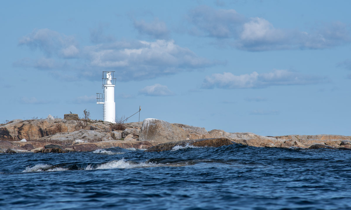
I continued paddling. First I had to cross some quite large waves then the sea was much calmer so that I could take a picture of the next island to visit: Kågnäshällan.

The calmness however was only temporary, because I kayaked along the outer coast of Kågnäshällan, where there are a lot of rocks and shallow areas – invitations for the waves to break. I went round the island, just focussing on the waves to come until I reached the sheltered bay on the land-facing side. On the outside I could hear the roar of a water scooter, at the horizon I could spot a white sail of a sailing boat – two very different ways to travel on water. My preference however is still the kayak.

After a yoghurt as a snack and remembering the last time I’ve been here six month ago I continued my kayak tour. To Kågnäshällan I had paddled quite directly over open sea, now I would follow the coast until I would be back again.

I passed Kågnäsudden, a fishing village, and a lot of summer cottages. Some people were working (mostly involving tools or vehicles with a motor), some were just sitting in front of their houses enjoying the warm and sunny weather. And warm it was, although some clouds were gathering. Since I left Kågnäshällan the sea was much calmer and I could take pictures from the kayak.

That made paddling much easier but also a bit more boring. It’s nice to have waves as long as you feel safe. Part of my safety was the drysuit that I put on when starting the tour. And a life vest of course, but that’s common sense and hardly mentionable.

Now I looked for the beach I use to bath sometimes but I just hopped over that very bay. What a pity! Anyway I found a nice replacement, a small and shallow sandy beach.

Lunchtime! The menu: Västerbotten cheese on crisp bread garnished with grapes. One of the ants liked the cheese, too and robbed a large piece. It dragged it over the beach that still was wet from last days rain until it got stuck.

After lunch break I continued paddling, passed the beach Harrbäckssand, the island Björkskär and then I could see on of the summer cottages, where my kayak uses to lie in summertime. One longer final spurt and I was back again, very glad that I could make this extraordinary fine summer kayak tour. Hopefully not the last for this season.

Appendices

I Paddling

More and more I start to enjoy paddling in the waves. I guess I should learn how to use a kayak sometimes. Perhaps next year?

II Tour stats

17.5 km / 3 hours 40 minutes plus a lot of breaks. That’s less than 5 km/h. It’s more leisure than sports.

According to my tracking app the elevation gain (and loss) was 287 meter. The waves?

III Wildlife photography

I saw the eagle, I had a camera, but I didn’t take a photo. Why? Well, there’s a rule set for that, the Eagle’s legals:

(1) When you see me – the eagle – you will not have a camera with you (I had)
(2) But if you have, then you will not have the telephoto lens with you (I had)
(3) But if you have, then you will not have it mounted on the camera (that’s right)
(4) But if you have, then you will be busy with other things until I’m long away (true, I was struggling with the waves)

IV A riddle

I found this shell of a cockle on the island Snusan. It lay on the rock. There are no cockles in the Bothnian Bay, this part of the Baltic Sea. The next place where you can find them is in Norway, 400 km away. How does this shell come to this place? I know that seagulls use to take shells in their beaks and let them fall down on rocks to crack the shell and get to the meat. But would a seagull transport it such a long distance? How? And why? A riddle that probably remains unsolved.