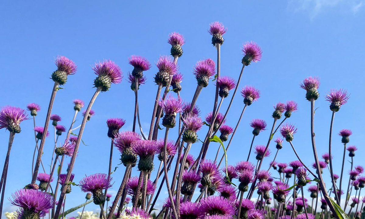
Autumnal kayak trip to Grindøya


These are no black-and-white photos. It is normal colour photos in a wintry landscape of black and white. When it is as cloudy as on Annika’s and my ski tour on Friday and Saturday, then the bright colours seem to have vanished from the landscape. The snow seems to be white, the clouds seems to grey, the rocky mountain parts to be black and so do the many birch trees. But if you look closer, you see that snow hardly ever is of pure white. Here, it might have a green shade; over there, a blue tint; and in an hour, a hue of purple.


This article is part of the series “2021-07: Back in Tromsø”.
Two quite different photos from a mountain tour in the Tverrfjellet on Kvaløya. In opposite to the forecast the weather was very cloudy.

Photo 1 – telephoto lens, 125 mm · developed in black and white with a light shade of blue.

Photo 2 – fish eye · developed with increased color saturation.
… and when I was halfway down the sun came out and half an hour later the whole sky was blue. My knees however disagreed in the idea of hiking 500 metres up again.
(Oops, I’ve become lazy with blogging. This happened already a week ago!)
Last week Annika and I used our one-week holiday to visit friends in Råneå – 300 km from home, 100 from the Finnish border. Three days – three sections.
After a sunny morning a large cloud front approached Råneå, bringing thunderstorms, heavy rain and hail. It was short-lived and probably only some strawberries were harmed. (Or was it a snail that tasted them?). In the afternoon it cleared up and we spent some time by (and in) a bathing lake.


We had booked the day before. Four kayaks (three single, one double) and a canoe. On tour: four children between 5 and 13 and five (more or less) grown-ups. We have booked for three hours and decided to paddle through a small creek and then take the Råneå river back to the boat rental by the sea. I have paddled quite a lot on the sea but hardly on rivers, streams or creeks. A great experience!


Annika and I had heard Daniel Wikslund before. On this day he played two open-air concerts in Överkalix – the first one on a large wooden raft on the river Råneälven. It was wonderful to listen to his folk-inspired music from the a small jetty, the water or even from the raft. It was his first concert since February 2020 due to the covid restrictions. Hard times for musicians!


You see the wooden keyboard instrument? That’s a pump-organ (Swedish: tramporgel). We’re lucky to have such an instrument in our house soon. Today we’ll meet friends that will help us with the transport from the previous owner’s summer cottage by the sea up the hill to the gravel road and then to our house. Wish us look, that the transport succeeds.
About neoprene suits, the post-glacial rebound and changed lunch plans.
Today I wanted to paddle to Själagrundet, an island 1.6 km from mainland. The air may be warm but the water is still cold and that’s the element you should be prepared for in case of capsizing. Today I decided against the bulky drysuit and chose a thin neoprene suit for the first time.
The suit is very tight (especially if you each too much chocolate …) and hard to put on. After I managed to squeeze myself into the suit and to close the back zipper it felt quite comfortable. Until I started paddling. It was much harder to move the paddle than usual because of the tight neoprene sleeves. Every paddle stroke felt like training with a rubber band. I got used to it after a while, but neoprene will probably not become my favourite choice of kayak clothing.

I passed the island Storgrundet and headed northeast. The waves came exactly from the side which is the worst direction regarding stability. So I zigzagged a bit to avoid the waves rocking the kayak too much. Nevertheless the island came closer and closer and soon I got out of the kayak and dragged it ashore. The seagulls didn’t like my arrival. Screeching loudly they rose in the air, sailed in the wind and didn’t dare to land as long as I occupied their private property.
There are many islands whose name ends with -grundet. From Skelleftehamn for example you can paddle to Storgrundet, Norrskärsgrundet or Nygrundet. The Swedish word grund means (among others) shallow, so the translations of the islands mentioned above are: the Large-Shallow, the North-Skerry-Shallow, the New-Shallow.
Who is to blame? The post-glacial rebound! After the last glacial period the glaciers started to melt. Slowly the land, that had been compressed by the huge weight of the ice sheet started to expand. It is still expanding and rising – round 8–9 mm a year. Therefore some islands are quite new. Själagrundet for example is hardly older than 100 years. They got their names from the old times when they weren’t islands yet but shallow underwater-banks that the fishermen had to take care of.
Today Själagrundet still is mainly a large gravel bank. Only on the higher eastern side plants had started to grow. Mostly it’s flowers, but two small bushes and a small willow tree have settled there as well.


I walked around and had a look at the 260 meter long island until I got hungry and wanted to eat my lunch – salad and a chocolate bar. When I looked at the dark grey clouds that seemed to approach the island I changed my plans. Did I hear the rumble of thunder? When I would be hit by a thunderstorm on this flat island without any shelter I could get into serious trouble. I checked the speed of the clouds and decided that the best option was to paddle back to mainland, now and quickly.

I had a fast start and paddled quicker than usual until half of the distance lay behind me. It was quite exhausting –remember the neoprene suit? When I realised that there was no immediate danger of thunderstorm and lightning I slowed down. I took my dinner on the island Storgrundet. A save place with summer houses and hardly 100 metres from mainland. Then I paddled back to the small beach at the mainland, took off the neoprene suit and had a refreshing bath in the Baltic Sea in the sun.

When it comes to Northern Scandinavia and watching the sky, most people will directly think of polar lights. It will take at least a month until it’s dark enough to spot them again in Skelleftehamn. There is however a great replacement: Clouds in the night. Since the sun sinks hardly below the horizon, sunset and sunrise melt together in the middle of the night. The sky is blue and the clouds are illuminated in warm purple and pink colours hard to describe (and to photograph).
I made this photo at 1:02, one hour before sunrise.

It’s only a weak copy of reality since I don’t manage to show the gentleness of the soft yet intense pastel shades of the clouds.
But to close the circle: That’s hard to show with polar lights, too. If you do not carefully edit the photos they may look like green porridge …
At last – the first paddling of the season! The sea ice came early this winter and remained until late April. In early May Annika and I visited Gotland for a week and when we came back spring had arrived in Västerbotten. Since then I was either working or it was too windy or I was too lazy.
Despite to problems with my elbow I decided to kayak today. It was mostly sunny and hardly any wind – good conditions for a start. As many times I started at the beach of Storgrundet which is 1.6 km to go. I used the waistbelt of my pulka and a cord for dragging the kayak behind on its cart without using my hands. Quite comfortable!

At the beach I put the cart aside, put on my life jacket and started the tour, that took me first round Storgrundet and then along the outside of the islands Storgrundet, Norrskär and Bredskär.


I took it quite easy to avoid overstressing my elbow. The first kilometre the elbow still hurted but became gradually better. I watched the blue sky, the approaching cirrus clouds, the ripples on the water and was glad to be on the Baltic Sea again. Last time I was walking …


When you paddle along the outside of Bredskär you only see forest and a stony beach. The summer cottages are on the other side. One of the cottages belongs L. and S., my neighbours. I went ashore and was welcomed by S., who invited me to fried herring, caught by net just the day before. Delicious! We sat outside and talked about everything while I deepened the friendship with dog Dolly.
Finally I left the island and continued my tour, slowly heading home. Thank you S. for the herring and nice company!


I arrived at Storgrundet round two o’clock but it took an hour until I was home. First I just had to take a refreshing bath. Yes, it’s definitely refreshing with a water temperature round 15 °C. My tight back however loves the cold water. Then I met another acquaintance and we had a longer talk. Finally I walked my kayak home where I arrived six hours after departure.
This article is part of the series “2018-03: Varanger peninsula”.
Day 29 and 30 of my winter journey 2018
Yesterday we continued our journey to Ytre Kiberg which is 13 south of Vardø, one of the Hurtigruten stops. We started in Vadsø – another Hurtigruten stop – after a breakfast with our host Nils, bought a basis of food for the next days and took the E75 northwards. We made a stopover in Ekkerøy, a village on a peninsula near Vadsø. We like this place and will try to stay there for some nights next week.
At lunchtime we reached Cape East Arctic Adventure, our stay for four nights. We were welcomed by Trond, the owner and operator of Cape East Arctic Adventure and were shown our cozy bedroom, the kitchen and the homely living room. After making ourselves at home we went along the beach to the village and the harbour.

In the evening we were invited to a three course dinner based on freshly caught cod: Fish soup – cod with potatoes and carrots and finally cod roe. Everything was extremely tasty and it was Annika’s and my first time where we tasted cod roe. Yummy!
In Kiberg you are as east as you can be in the Central European Timezone, therefore sun is rising already at 6:24. I was awake very early and took a morning walk round 6 o’clock. Some snow drifts had been created by snow and wind over night but now the weather was less windy and quite sunny. At least for a short time. While I went the way to Indre Kiberg clouds approached, wind increased and it started to snow. It was hardly imaginable that it was sunny just a short time before. Weather changes here quite often as Annika and I should find out later.


After breakfast Annika and I took the car to the other side of the village, put on our snow shoes and started a hike to Kibergsneset, easternmost point of mainland Norway. This place is more east than e.g. St. Petersburg, Kairo or Istanbul! It was windy but quite sunny, when we started our tour but weather changes fast on the Varanger Peninsula:


Actually this hike is just a promenade but the weather may transform it into a small expedition. We were exposed to wind and snow and grateful, that we didn’t experienced a full storm. The weather was rough anyway and I was glad about my windproof jacket and two pairs of mittens.


We continued on a small hiking trail, first with, then without snowshoes because the thin snow layer was hardened by the wind and easy to walk onto. There’s a coastal fortress build by Germans in WW2 on Kibergsneset but we couldn’t see it in the snow weather. Instead of looking for it we continued to the small lighthouse at Kibergsneset that marks the easternmost point of mainland Norway (and most of Europe). Shortly before we reached it the sun came out and we continued the last metres in full sun. While I made some photos a small snow shower approached with the sun still shining.

From the lighthouse there was an amazing view over the arctic coast of the Barents Sea, but only for some moments. Soon the next snow shower came by and hid most of the view onto both the coast and the sea.

The way back was much shorter because we knew the way and went downwards. Even though the view was limited by the snow showers Ytre Kiberg came into view again soon and surprisingly the weather was nice and sunny again.

After this very windy promenade we were glad to find shelter in my car. We took the car to Vardø to eat something and after that we tried the road to Hamningberg. We knew that the road was closed in winter but we curious how long we would come.
Well, not very long. We managed to get to Smelror, some kilometres north from Vardø.


The main road however was definitely closed as you can see. There are no people living in Hamningberg permanently and the only motorised way to reach it in wintertime is by snowmobile. For car it is open less than half the year.


We took the car back to Kiberg, enjoyed the incredible and unbelievable colours of the sky and were surprised by a strange weather phenomenon: -6 °C and rain (including a faint rainbow!)

The rest of the day? -10 °C and wind outside, no more photos, no more excursions.
Fun fact: We took the E75 northwards. If you would take it southwards you could travel more than 4000 km and finally would arrive on Crete, Greece.
This article is part of the series “2018-02: Ski tour near Kvikkjokk”.
Day 8 and 9 of my winter journey 2018
After the first night in the tent (it was a cold one!) we were eager to continue the tour. The tent was packed and so were the pulkas. We started by skiing through powder snow – a slow movement. I guess I hardly reached 2 km/h in average and I definitely was much slower when I had to go uphills. We looked for a good place to access the river again since it was much easier to follow the stable snow on the snowmobile tracks. After a while we found a good place to enter the river bed. Mostly the winter trail followed the river, only twice it continued on land where the river is narrow and had open water.
After some kilometres the river bent southwards and our trail left the river to continue more westwards. We continued the snowmobile tracks that led through forests and over smaller bogs.

We started to think about reaching the mountain hut Njunjes but weren’t at all sure if we would reach it before darkness. Anyhow, we didn’t had any pressure, since we had anything with us which we need for tenting:
The way was easy but the pulkas were heavy loaded and after hours of walking I started to get tired and exhausted. That’s one of the reasons why I hardly made any photos. Another reason was that both my cameras refused to work in the morning with temperatures round -30 °C. It became warmer, but it was still round -25 °C, although it had become cloudy and overcast that day quite early.
Beside of a longer and a shorter rest we continued skiing, now with the defined goal to reach the hut. It started to get dark but we knew that we only had to go another hour or a bit more to make it.

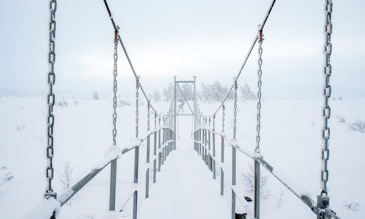
After a while it went so dark that we skied with headlights. The buildings of Njunjes had come into view but they were on the other side of the river. When we were on a level with Njunjes we realised that the river became a quite deep ravine, probably with open water and quite impossible to cross …
… but we were really lucky: there was a metal chain bridge that led over that very ravine. It was quite a fight to climb up the slope after crossing the bridge, but with a lot of pulling (and without our skis) we managed it.
Soon Jonas found the open winter room with was made for people like us who like to travel off-season. A stove, wood, a bunk bed for two people, hooks for drying clothes, a table and two stools – anything to stay here for a night or two.

Day three was a day off. It was warmer than the day before and mostly dim and cloudy. I took pictures of the chain bridge, the mountain hut and the landscape (as far as it was visible)


After breakfast we attached new climbing skins to my skis and took a ski tour. First cross the river again and right to the sun. Then up some minor hills through sparse birch forests and eastwards to meet the branch to the hut that we had missed the day before. The skins worked well but it was almost a pity to have them attached to my skis since they slowed me down when skiing downhills through the loose powder snow. The sun was hardly visible through the clouds and the landscape almost looked sepia – like an old black and white photo.


First it only snowed a bit but when we finished our tour and arrived at “our” mountain hut snowfall increased. While Jonas was busy sawing and chopping wood I took a small nap.

In the evening we planned to continue to Tarrekaisestugan the next day – the next mountain hut in the west – and probably to continue and tent again in the wintry forests.
Photo #2 in this blog article is made by Jonas Balbasus.
It snowed, dark clouds sped past the coast, the sun illuminated the fresh snow and the gusty wind blew it around. The weather changed constantly this morning. The wind squalls made the temperatures of -3 °C appear much colder and I regretted that I went outside without windproof trousers and warm gloves. That’s the post-wintry release of Norrlands April weather.


The easter days shall be wintry as well with temperatures between -8 °C and 0 °C, at least here in Skelleftehamn. In the mountains however they’ll probably drop to -20 °C or even below.