Travelling to a new country

Finally I’m travelling again. A trip to a country I never visited before. Annika and I are sitting at Arlanda airport and waiting for the connection flight to …

… well, which destination are we travelling to? Your guesses?

Addendum:

My blog had a small bug that I discovered right before entering this plane. This is my first flight ever with WiFi, so I was able to fix it up in the air while flying over Sweden’s inland.


Flying to Iceland

Saturday, 25 August

After an early flight from Skellefteå to Stockholm Arlanda Annika and I switched plane and airline. For the first time in my life I travelled to Iceland, where we would spend the next two weeks.


The Atlantic ocean was mostly cloud covered. We could only spot some offshore platforms off the Norwegian coast before the cloud layer became too dense to see anything.

A good opportunity to play around with the entertainment system of the plane. Icelandair, I’m really impressed! Miles Davis · Bitches Brew, John Coltrane · A Love Supreme, Ligeti · Piano works, Steve Reich, Karlheinz Stockhausen … . And that’s only an excerpt of  fJazz and Classical Music aboard. Great music and a good reason to favour Icelandair before other airlines in the future.

Shortly before approaching Iceland however I could see something different, as white as the clouds but of another shape. A glacier, the first sign of Iceland. Shortly after this the cloud layer broke up and we had a fine view of Iceland from above.

The plane descended and started approaching Keflavík Airport. Welcome to Iceland!

Landmannalaugar

Sunday, 26 August – Monday, 27 August

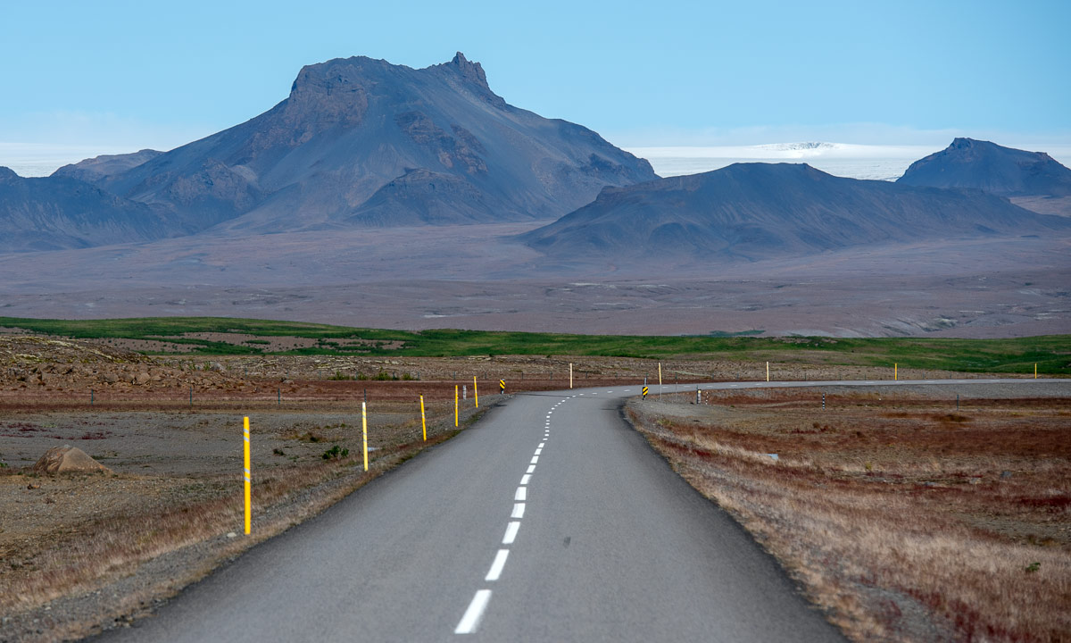
There are only a few roads leading across the Highlands of Iceland. Most of them are only open for cars with four-wheel drive because it is necessary to ford rivers. Even though the road to the Landmannalaugar, our destination for Sunday, is not the toughest, we decided not to hire such a car. They are expensive, we don’t have any experience in fording and there are busses making such trips as well.

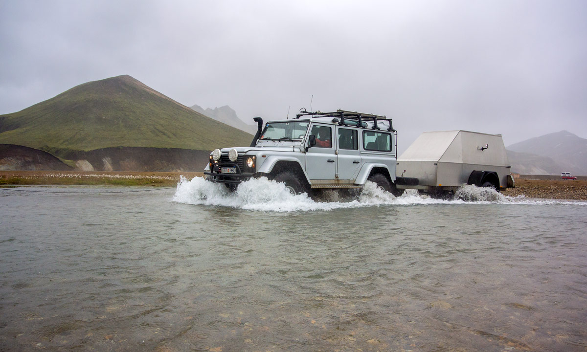
Sunday morning we entered the bus to the Landmannalaugar. The whole trip takes round about four hours and goes mostly on normal asphalt roads: through Reykjavík, along the Ring Road that runs around the island, then along a minor road. Finally we reached the junction where the gravel road starts and the bus ride became a bit jumpy. We met some other cars, some of them huge jeeps, some of them small SUVs. After a while we approached the first ford, where a small Dacia Duster crossed the water, followed by our bus.

The other two fords are within sight of the Landmannalaugar mountain hut. There were deeper and many of the drivers with smaller cars decided to use the parking place nearby instead of fording. The bus however splashed through the water and brought us to the mountain hut, where we had booked two places to sleep.

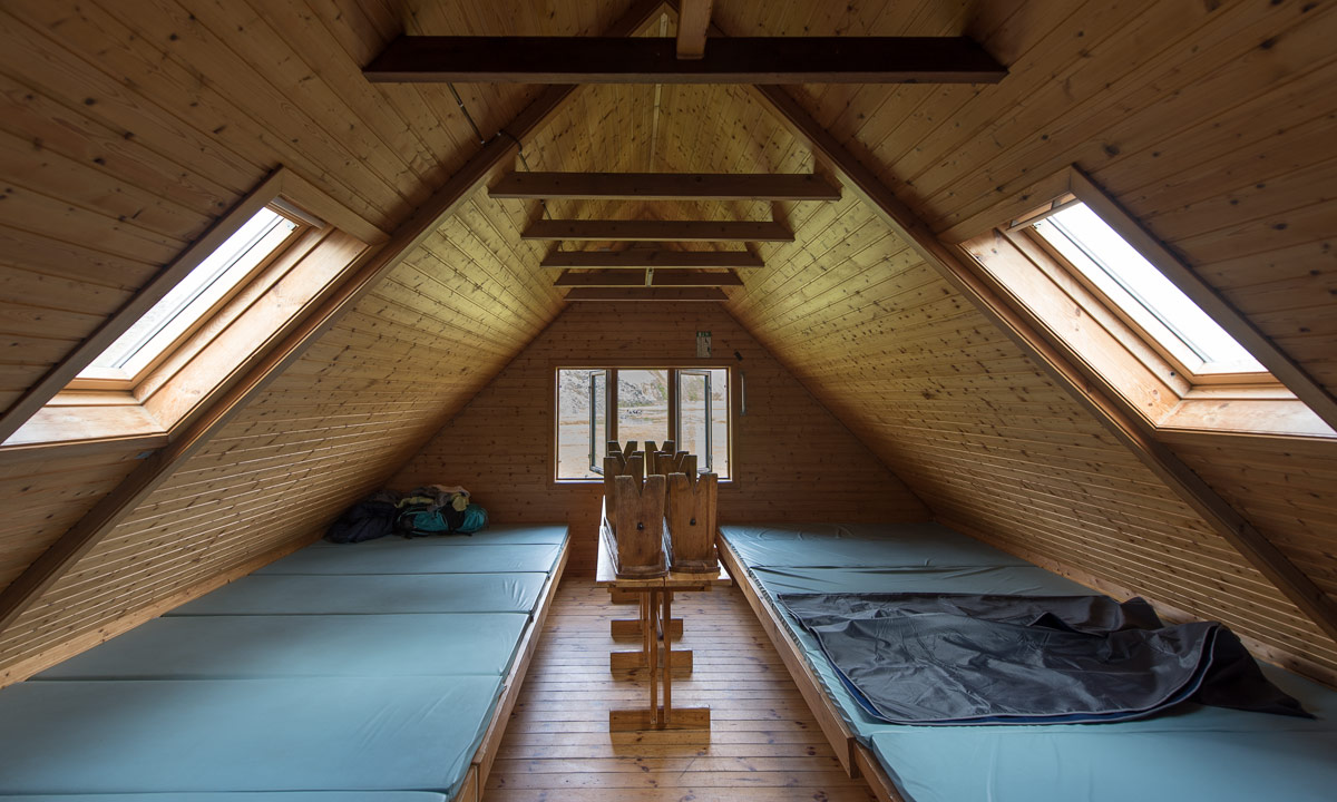
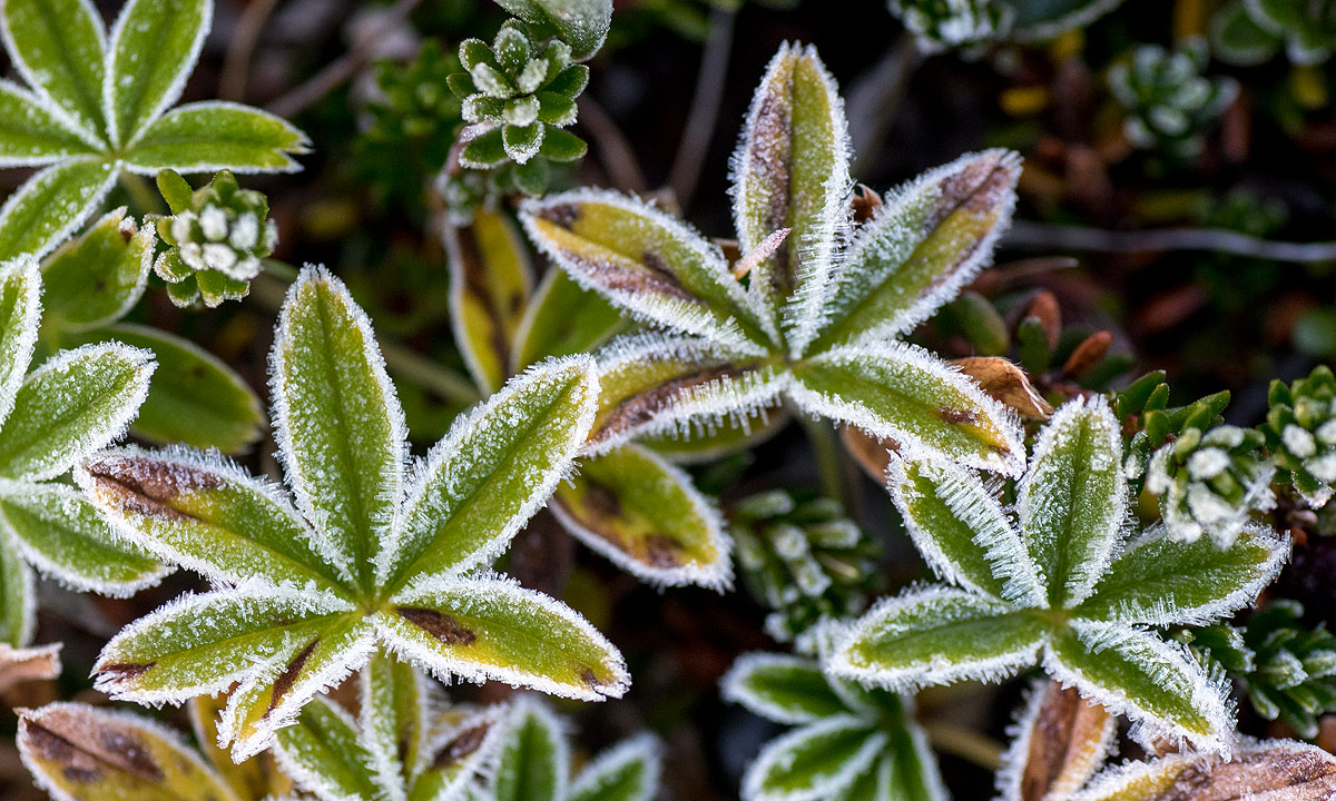
After we unpacked our sleeping bags and put them on two of the narrow mattresses we put on our jackets and boots and started a hike through the amazing landscape. Annika has been in Iceland before several times and told me about the almost unbelievable colours and shades of the mountains and she was true. Some of the mountains were orange, some brown or yellow, some green and one of them red. The lava rocks were black, partly covered with white-green moss and the higher mountains had white snow fields on their colourful slopes. Take a look by yourself:

Iceland has a lot of tourists, last year more than 2 millions. To protect the sensitive environment and avoid destroying the flora you mustn’t leave the trail. There’s another reason for sticking to the trails: Iceland has many geothermal areas where you could break through the thin crust into bubbling mud or boiling sulphuric acid. Some of these spots are visible, they smoke and you smell the sulphur compounds.

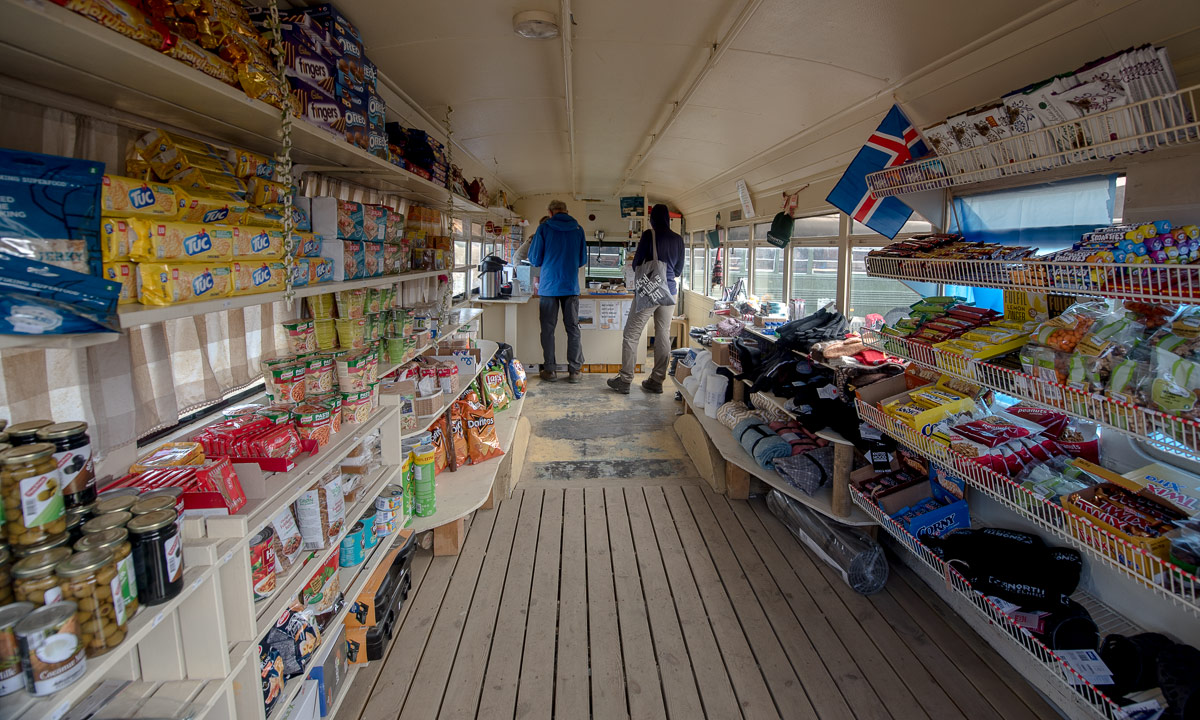
After some hours hiking (including an ascent of a mountain) we returned to Landmannalaugar. There’s not only the mountain hut providing 75 beds and a camp ground with place for at least hundred tents, there’s also the Mountain Mall, an old bus where you can buy food.

We enjoyed a rest with two cokes before we headed to the next attraction: A warm bath in the river. Because of the geothermal activity the ground is partly hot and heats up the water to temperatures between round 30 °C and 42 °C. We were not the only ones bathing, but there was enough place for all. You could even decide how warm you wanted your bath by just moving another metre. Great!

After a saturating dinner with spaghetti and pasta I took another walk and some more photos. Then I went to our room and got to bed.

Amazing! Although more than 15 people had slept in the room and the mattresses were so narrow that we could hardly turn around Annika and I slept very well. It was very quiet, hardly any snoring, no talking, no rustling with plastic bags. I experienced much worse when I had spent nights  in alpine mountain huts in Germany or Austria.

After breakfast we took another bath and then another hiking tour. I hardly made any photos due to the drizzle and the strong winds. At least I could take some pictures of the sheep grassing on the plain.

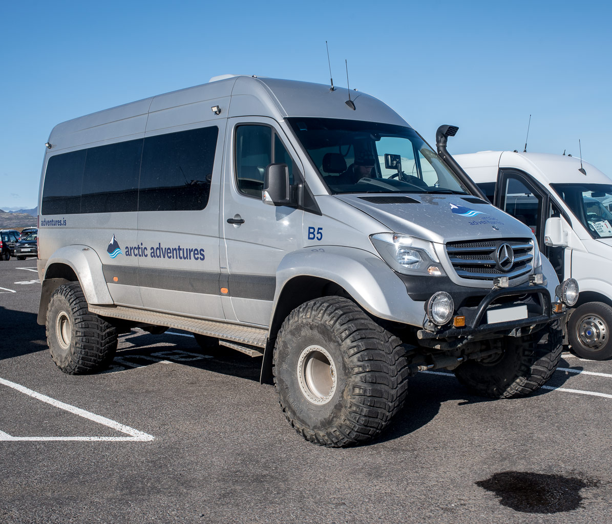
Drizzle became stronger and turned into rain. We went to the ford and looked at the cars crossing. This time I had my waterproof camera with me. Look at the snorkel of the white jeep, I guess this car could almost dive!

The rain got stronger and stronger and when we entered the bus our rain clothes were soaking wet. I looked through the rain-wept window for a while, tried to make same photos, but the autofocus couldn’t handle the situation. After a while I fell asleep.

Conclusion: A great experience! Yes, Landmannalaugar is touristic and crowed, but for good reasons. It’s absolutely worth a visit. Here you can even start a four-day hiking trip but you have to reserve the mountain huts years before. I’m quite eager to do this trail, perhaps in 2020 …?

Hveravellir

Wednesday, 29 August – Thursday, 30 August

After our long bus tour we arrived in Hveravellir in the Highlands of Iceland. Hveravellir lies 650 metres above sea-level and here you can find geothermal areas, where fumaroles emit hot gas, mostly water, carbon dioxide and hydrogen sulphide. The latter one is responsible for the smell of rotten eggs.

We went along the wooden path (don’t leave it, the crust is thin and boiling hot!) and looked at the fumaroles. Then we continued a path westwards.

The landscape scenery changed. The path led mostly through lava rock, only sparsely covered with soil, moss, grass and some flowers.

Some sheep were grassing here and there. They preferred the grassy parts of the desertlike surrounding.

The willows however had to cope with the soil that they had got and even more with the weather. There were flat and crouching on the ground to avoid exposure to the wind.

The way we chose is no circular track so after a time we had to return to Hveravellir, where we had booked an overnight stay. We used to wooden bridge to cross a small stream. You have to be careful, the water is hot!

“Home” again we cooked tortellini for dinner and bathed in the hot tub that was located right beside of our mountain hut. While Annika stayed in the hut after that I took another walk and enjoyed the evening light. The sky was clear and the sun was shining. (And I thought, it would only rain on Iceland!) The motives? Smoking fumaroles against the light · glaciers and snow covered mountains far away · sheep nearby.

I slept very well but woke up quite early. Time for another walk, this time enjoying the sunrise.

The night has been cold and ice crystals covered flowers and leaves. The wet parts of the ground were covered with hoarfrost that looked hairlike.

The fumaroles enveloped the geothermal areas in steam. I can do without the sulphuric smell, but the look is very impressing, especially with the warm sunrise colours.

After my early morning walk Annika and I had breakfast and then packed our stuff. The bus back to Reykjavík wouldn’t leave before 12, so we had time for a two-hour walk together, this time heading south. One of the things that make Iceland unique for me is the colours, not only the colourful mountains in Landmannalaugar, but even the moss and the grass looks special. And the volcanic lava rock is so sharp that the photos look oversharpened.

Round 11 o’clock we had returned to the parking place waiting for the bus. But we spontaneously changed plans when we met Matti whom we got to know in Reykjavík some days ago. He was here by car and invited us to join him and his friend. They wanted to drive to another place, hike around then return to Reykjavík. We happily agreed and had a great time, but that’s another story …


Icelandic letters

While the latin alphabet has 26 letters, the Icelandic alphabet has 32. C, W, Q and Z are not included. So the Icelandic alphabet has ten extra letters that are not part of the latin alphabet.

The first 6 letters are vowels with an accent that changes the pronunciation. It’s ÁÉÍÓÚ, and Ý. Two others are vowels, too: Æ/æ and Ö/ö. The letter Æ is also used in Danish and Norwegian, while Ö is used in e.g. the Swedish and German language.

There are two letters however, that are a bit special: Ð/ð and Þ/þ. The letter Рis called eth and its pronunciation resembles the th in that. The letter Þ comes from the runic alphabet Elder Fuþark and is called thorn. It is pronounced like the th in thing.

When Annika and I took the bus to Landmannalaugar some days ago I spotted a sign on front of a house. It contains 5 of the special letters: The Ö, the Æ, the Ð, the Þ and the Ó.

What does the word Lögfræðiþjónusta mean? Lögfræð means law and þjónusta means service, so the whole world means “legal services”.

A special place in the Highlands of Iceland

Thursday, 30 August

When Annika and I were in Hveravellir waiting for the bus back to Reykjavík, we met Matti whom we got to know some days ago. We gladly accepted his invitation not to take the bus but to follow him and his friend by car.

First Matti followed the very same way that the bus would have taken, but soon he turned in another gravel road that led us up a slope. The path got worse and worse and I was glad that Matti has an old Nissan Patrol and knows how to handle it when crossing a ford or driving through deep clay mud. The gravel track ended in a parking place with a tiny toilet. From this point we had to walk.

I stood at the rim of the parking place and was stunned by the iconic view.

I could see coloured mountains everywhere as in the Landmannalaugar, many of them covered with old snow fields or small glaciers. The scenery was partly covered with steam that emerged from fumaroles as in Hveravellir, but here were hundreds of them.

We followed the path and descended the clayey slope on some ridiculously steep looking steps. This geothermic area is very active and constantly changing. Sometimes a fumarole is less than a footstep away. We crossed a bridge, partly hidden in the steam emitted by boiling water pools, were Matti cooked some eggs.

We continued our hike and ascended another clay hill. From here we could see many other hills and stairs leading up and down.

We came nearer and nearer to an old snow field. Here the normal path came to it’s end.

One path led up the slope over the snow. We continued another path that led to the top of a slope. From here we could see huge snow blocks that had slid down the clayey slope. Matti, his friend and I went down that slope. The ground was extremely slippery and when I arrived down in the valley my rain pants were completely covered with wet clay. The weather worsened: First it drizzled, then it even snowed a bit and in addition of that the steam of the fumaroles was everywhere. The following photos of the snowy ice blocks were the last ones before I gave up making pictures, because camera and lenses became too wet and muddy.

It took I while until I managed to crawl up the slippery clay slope again. We started heading back. The wind had increased and on the last crest-like hilltops it was really stormy. Luckily the storm was not strong enough to blow us over. Anyway I was glad to be in the shelter of the car again.

This place is really special. Not too easy to hike when it’s wet, but both interesting, varying and extremely beautiful. Of course other people know this place as well but at least there are no commercially guided tours yet. To keep it that way, I promised not to reveal the location of that place although Iceland experts probably have recognised it already.

Thank you, Matti for this experience, the long drive back to Reykjavík and the lift to our guesthouse!

Seljalandsfoss and Glúfurárfoss

Friday, 31 August

Yesterday Annika and I went into phase 2 of our Iceland holiday. We hired a car for a week. We had booked a VW Polo but we were lucky and got a brand new VW Golf as an update. That’s a great car to drive the 1332 km long Route 1 round the island (and probably some detours). We got our car at 12:30, went shopping and left Reykjavík as fast as possible to follow the Route 1 counterclockwise.

The first stop was at a huge parking place, where you could see the Seljalandsfoss, a 65 metre high waterfall. It is special in the way, that you can go round watch it from all directions. We were not the only ones, hundreds of other tourists went round as well, many of them without proper rain clothes and soaking wet.

A gravel path led to another waterfall, the Glúfurárfoss. It is not easy to reach, because you have to enter a hollow and wade through a stream to get to it. This waterfall may be less impressive in height and amount of water, but the scenery is more special, almost enchanted than the Seljalandsfoss. I was very glad to have not only rubber boots but also my waterproof camera with me, but half of the time I was busy with keeping the lens dry.

Black beaches and glaciers

Saturday, 1 September

Yesterday we hired our car, today we had the first full travel day round Iceland. We didn’t make many kilometres, since there are so many beautiful places along the Ring Road in the South of Iceland. There are quite famous, too, so we had to share them with a lot of other tourists.

Dyrhólaey

Dyrhólaey is a 120 metre high peninsula which is known for a large hole in the rock that gave the place its name: “door hole island”. Huge waves rolled ashore and broke at the rocks. No place for bathing.

In the east we already could see the Reynisdrangar, pillar-like rock formations in the sea. The sea was covered with spray and looked almost white, just like the sky.

Reynisfjara Beach

Reynisfjara Beach is the most famous of the black beaches near to the town Vik. Unlike most other beaches the sand consists of eroded volcanic rocks. The waves were as high as those visible from Dyrhólaey and many signs warn against the danger of being swept away. The beach at the parking place is quite is flat and white and the waves flood great areas of the black sand.

While I was taking these photos a huge wave came and pushed a lot of water to the beach. I got wet feet even with my rubber boots on.

From here you can also see the Reynisdrangar standing stoically in the sea. Only seabirds inhabit these inaccessible rock pillars.

One of the main attractions of Reynisfjara Beach are the basalt columns. Well, I tried to take photos, but this was impossible due to the many, many tourists standing there. At least the basalt cave was free of people for a minute.

Svinafelljökull

We found a nice overnight stay in Svinafell. As all accommodations it was expensive and you would get a hotel room with breakfast for less money in most other countries. Iceland however is an expensive country and you should know that before travelling there.

Quite near Svinafell there are two glacier tongues, Skaftafellsjökull and Svinafelljökull. Both of them are part of Vatnajökull, Iceland’s largest glacier and you can see them from the Ring Road.

After checking in we returned to the Ring Road and turned into a gravel road leading to the Svinafelljökull. This was the worst road I ever drove. It was just 2.5 km long, but only made of deep potholes and rocks. It took me 15 minutes for one way. There’s a reason why so many people use jeeps or pickups in Iceland. Anyway it was worth the efforts, despite the grey weather.

Some photos:

Next day we would continue east and perhaps reach the East Fjords.

From glaciers to the East Fjords

Saturday, 2 September – from Svinafell to Reyðarfjörður by car

Annika and I woke up quite early and left our cabin in Svinafell already round 8 o’clock. That’s why we were almost alone, when we came to the lake Fjallsárlón into which the glacier tongue Fjallsjökull calves. Some larger and many small icebergs floated on the brown glacier water. We walked along the shore, touched some of the small ice blocks and watched them floating into the creek Fjällsá.

When we left the beach of the lake, many more people arrived, although this “first lake” is not as the “third lake”, the Jökulsárlón. The latter is much more touristic. Many cars stood on the huge parking place and hundreds of tourists walked around, taking pictures or took tours with zodiac boats or amphibian vehicles. The good thing with cold lakes: You always find the opportunity to take pictures without any  tourist.

We didn’t see many animals yet on Iceland, beside of many sea birds and of course countless sheep (mostly in groups of three) and Icelandic horses. Here we saw the first wild mammals: seals swimming around in the lake, diving and reappearing again after some time.

After we left these lakes behind and continued east, the traffic on the Ring Road decreased more and more. We were on the way to the East Fjords that are far less touristic than the south of Iceland. It was just fun to drive the Ring Road and watch the scenery changing. Just a few pictures from some of the breaks we made.

It was quite late when we arrived in the coastal town Reyðarfjörður, where we got a room with an own bathroom. Time to cook and wash some clothes.

The next day we would leave the East Fjords and head north.

Through the windscreen

Monday, 3 September

Today it was Annika who drove the car. I was front-seat passenger and took photos through the windscreen.

The route today: ReyðarfjörðurEgilsstaðirVopnafjörðurBakkafjörðurÞórshöfnRaufarhöfnKópasker.

As you can see: Nice weather!

As you can see: Not too many cars!

Some more photos to come, perhaps tomorrow …

Jökulsá á Fjöllum

Tuesday, 4 September

Jökulsá á Fjöllum (glacial river in the mountains) is a river in the North of Iceland and offers some interesting places. We chose the road 862 on the western side with destination Dettifoss, Europe’s most powerful waterfall.

After some kilometres the asphalt road suddenly changed into a single-track gravel road, which was in a quite bad shape.

Some kilometres further at the turnoff to the Hljóðaklettar the road to the Dettifoss became an “F” road, meaning that it was open only for off-road vehicles. At least we could turn left to Hljóðaklettar which is known for its basalt columns. Here we parked the car and took a circular walk.

After our walk we had to drive back the whole bumpy road, turn east, cross the river and use the road 864 on the eastern side. It was quite bad, too, but at least we were allowed (and able) to take the road and finally arrive at the Dettifoss. We were lucky, since the eastern shore is more crowded and farther away from the waterfall.

Here some snapshots:

From this place you also have a gorgeous panoramic view of the canyon that leads to the north. If you followed this canyon you would come back to Hljóðaklettar.

Bathing in Sæberg

Wednesday, 5 September

Relaxing in a hot pool.

Relaxing in a hot outdoor pool in Sæberg, Iceland. In the beginning of September. With an air temperature of round 8 °C.

How is that possible? Iceland has so many geothermal areas, where the ground is hot, that hot water is freely available in many places. Our hot pool today had round 38 °C. If you wanted to cool down, you just had to go to the beach of the fjord Hrútafjörður and take a bath there. There the water was at least 30 °C colder. We started with the cold bath, but stayed much longer in the comfort of the hot pool.

Sæberg – Hólmavík – Ólafsvík

Thursday, 6 September

From our overnight stay Sæberg it’s only 177 km to Reykjavík, where we had to return our hired car. That’s not much for one and a half days by car. Therefore we decided to take some more detours.

First we followed the road 68 to Hólmavík, a city on Iceland’s West Fjords. We continued along the coast until we came to a junction, where the gravel road 608 crosses the peninsula. It would be possible to go round the inhabited part of the peninsula, but that’s a detour of 390 km.

Quite near the fjord Þorskafjörður, there’s a small city called Reykhólar. We considered staying there over night but since it was still quite early, we continued instead to the peninsula Snæfellsnes.

The weather had been warm, sunny, calm and friendly for the whole week. But now it worsened, low clouds appeared, it started to drizzle and got very windy. In Ólafsvík – yes, I have my own bay ;-) – we found not only a nice hostel to stay but also a nice restaurant that served us a delicious goat cheese pizza.

Sorry to say, I didn’t make a single photo from Ólafsvík that day. First we were too busy with our dinner, than with re-packing our belongings, because the next day we would have to return our car. Than it was too dark to take photos without tripod and too stormy to take photos with tripod.

The only photo I made is a snapshot I took from the bathroom the next morning. Still stormy, still rainy.

Faroe Islands and Shetland above

After two weeks in Iceland Annika and I fly back to Sweden today. The first flight from Keflavík to København (Copenhagen) led first over the Føroyar (Faroe Islands), then over Shetland. Luckily there were some holes in the clouds to peek through.

Missing Iceland article I – Reykjavík

While I showed a lot of photos of the varied Icelandic landscapes the last two weeks I didn’t write anything about the main town Reykjavík yet. More than a third of the Islanders lives there and almost two-thirds of the Icelanders in the Greater Reykjavík region.

I’ve never been in Iceland before and was curious about Reykjavík, too. Anyway I have to admit, that I prefer the smaller towns, the rural areas and the uninhabited landscapes, but I want to show at least some photos I took.


Missing Iceland article II – the cars

Icelandic tourists come from all over the world. They are young or old, rich or not so rich (best not to be poor, because Iceland is expensive), hip or square, but most of them have one thing in common: their hired car.

As long as you do not choose the three-day ferry crossing from Hirtshals in Denmark or go on a cruise you will arrive in Iceland by plane. Since Iceland has limited public transport, it’s best to hire a car. Many tourists do. Some models are quite popular as for example the tiny Hyundai i10 or the ever-present Dacia Duster with 4WD.

There are however roads in Iceland, that you may not (and cannot) drive with such cars, the so called F-roads. F stands for Fjall, the Icelandic word for mountain. The challenge of these F-roads is however less the roadway itself but the river crossings. So you may not manage most F-roads with your average “pick-up-the-kids-from-school”-SUV.

That’s were the real off-road vehicles come into play. I saw a lot of of them, some with Icelandic registration but many coming from Germany, Switzerland or other countries. Some are classical off-roaders as the Land Rover Defender, while others look more like armoured military vehicles. Some of them have foldable roof top tents, some are buses used for touristic day trips.

I have to admit, that I like such cars but I definitely have no use for them. My Subaru Outback probably never will ford rivers, but I’m sure that it consumes less than half the gasoline than even the smallest of the off-road vehicles shown above.