Rekvik – a place to visit again
The weather was overcast and we were hungry, but the short hiking trail starting in Rekvik on Kvaløya is definitely a place to be visited again. With better weather and more time to take pictures.


The weather was overcast and we were hungry, but the short hiking trail starting in Rekvik on Kvaløya is definitely a place to be visited again. With better weather and more time to take pictures.
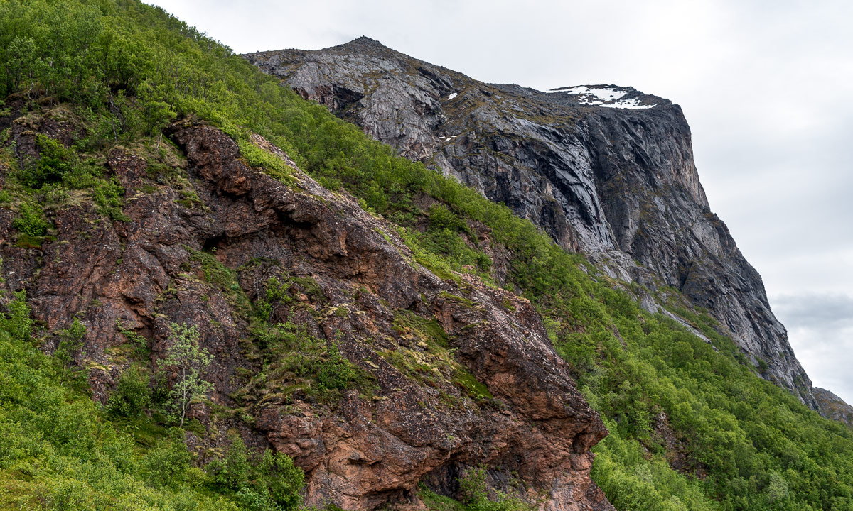
Slåka (314 m) and Guratinden (424 m) are two mountains on the island Kvaløya. I know them from my book “På tur i Tromsø” where they are described in tour 7. This tour is marked as green, which is the easiest category in this book. I chose it because on the higher mountains there still might be some amount of snow and I wanted to avoid that.
I took the car to the parking place in Skulsfjorden yesterday. The parking place I already knew from another tour. Then I tried to find the hiking trail while the cows starred at me curiously and the bravest of them came to sniff at my hand.

It took a while until I found the way which was not were the map showed it. It forked quite soon and maybe I followed the wrong direction because somewhere over the tree line it faded away somewhere in the heather. Way marks and sign posts you will hardly find when you hike like this in Norway. It is assumed that you can orientate in pathless terrain even on beginner tours. Anyhow a way to the top of the Slåka was easy to find without paths. Here I had a fantastic 360° view. In the north the mountain Nuortagáisi (or Nordtinden), in the south the fjord Kaldfjorden, in the west the island Vengsøya and behind that the open sea. And where there was no sea there were mountains, mountains, mountains, all higher ones still covered in snow.

Without any break I continued to the Guratinden. Again I could not find a reliable hiking trail but more a patchwork of paths, some of them probably animal tracks. Anyhow it’s not far to the Guratinden, where I took a rest to enjoy the view and something to drink.


Although it was the beginning of June it was very chilly on the summit, mostly because of the strong wind. I guess it was 7 °C and at least 15 m/s. Already on my way up I wore gloves and a woollen cap, now I was really glad about my down hoodie. Without I wouldn’t have taken any rest.

On the way back I followed other trails and tracks or I just cut cross country. Sometimes I walked on rocks, sometimes on boggy ground but mostly on heather.


Round three hours later I was at my car after 9 km hiking and round about 650 metres in altitude. And here you can see how it looks on the map when you hardly follow any trails ;-)


38.5 km by car, 5.5 km by foot. Some hundred metres in altitude. Warm and windy weather. Forests, slopes, shallow bogs, mountain paths, water to ford, flowers, snow fields, lakes, tundra, rocks, views to the mountains of Kvaløya, the fjord, the open sea and Greenland. OK, cross out the last point. Anyhow, quite much for a short after work promenade.
Yesterday at 18:00 I took the car to Elvenes on Kvaløya to start a small mountain tour. Well, mountain or hill – the summit of Grønnlibruna is only 401 metres above sea level. I chose this destination in the hope that it was not completely snowed over as the higher mountains still are.
I parked the car, walked the gravel path and stood before the first obstacle, the stream Finnelva. I did the same tour last November, where it was easy to cross. Now in the thawing period the water was at least 50 cm deep and quite fast . Too deep to cross here, even with rubber boots. Luckily I found a better place to ford a bit upstream. Soon I was in the forest. A very wet and muddy forest where I was not always sure whether I followed the way, crossed a swamp or waded in a brook. But this stopped when I gained a bit of altitude where old snow covered the forest floor.


As soon as was above the tree line the landscape changed again. There were some large snow fields but most of the ground was bare of snow and easy to walk on.


After 4 km of hike and some hundred metres in altitude I stood on the summit enjoying the circular view while the weather cleared up more and more.

I did not take a break but hiked down again. I enjoyed the weather and the fact that the birch trees start to turn green, at least in the lowlands. I crossed Finnelva a second time, now with a sturdy stick that I had found on my way. It’s much easier to keep balance with such a “third leg”. From there it was not far to my parked car that I reached round 21:30.


When I left the supermarket in Eidkjosen it was 22:00 and the sky was blue. It won’t get dark because the last sunset in Tromsø was more than a week ago. Since then we have polar days with 24 hours of daylight. I could drive home or …
I turned left. Left to the road 862 that leads to Sommarøya. Maybe I catch the midnight sun. Sometimes I had to drive slow because of the reindeers, sometimes I had to stop to take a photo …


… but round 23:00 I had crossed the bridge to the island Sommarøya and shortly after I parked at the sandy beach Steinsvika. I was not alone. People stood at the beaches, some lit a fire, some paddled kayak, some camped in the hills.
I checked an app when sun would be lowest. What? 0:45!? I forgot, that we had daylight saving time, so clocks were one hour ahead. I took my camera bag, some water and an old jacket, that I use to have in the car and walked to the northern tip of Kvalneset. Now I had a lot of time to just observe the sun hardly going down. After one and a half hour it was time: 0:45 – the sun was at its lowest position: 1.55°. The photo is completely unspectacular because it only shows a low sun, not the fact that the sun would not get lower than that this night.

I was glad about my jacket because it got a bit colder, I was tired and I sat there for almost two hours in total. At least I had chocolate! I waited for the sun to disappear behind the prominent silhouette of the island Håja.


Then I went back to the car and had about an hour drive back home. I wasn’t in bed before 3:30 but it was completely worth it. For a very good reason: I never ever saw the midnight sun in my life before! Although I have lived in Northern Scandinavia for more than 12 years I hardly was above the arctic circle in summer and then it was cloudy.
But it was more than just checking another item of my bucket list. It was just gorgeous to sit there and enjoy nature. I should do that more often and put the old sleeping bag back into my car. Just in case …
… this was the Facebook event I was invited to some weeks ago. It was an event organised by people from TSI Trulle, the other kayak association, but it was open for non-members, too. The idea was to start a kayak tour in Skarsfjord on the island Ringvassøya, paddle to a beach, clean it, cross the fjord to another beach, clean it, too, relax and paddle back. We were eight people joining the tour from five different countries.
Our tour does not start on the water. It starts with carrying kayaks to a trailer, use lashing straps to fix them there, packing all equipment into two cars and some driving.


After 50 km – one hour drive – we arrive at the parking place by the sea, where we unstrap the kayaks and get everything ready including testing the sprayskirts and the footboards. Things you can do on land as well as you see.


It always takes some time to put on the drysuit, check that everything is packed and working but then we all sit in our kayaks and are ready to paddle to our first destination: The islet Teistholmen.


We leave the kayaks there, take a huge rubbish bag each and start combing the shore of the island. Most of the rubbish is on the northwest side of the island that is most exposed to the elements. Mostly it is plastic from fishing. Parts of old green nets, buoys from small to football size and then of course all the civilisation garbage as empty (or half-full) bottles, styrofoam and some nasty stuff. But it’s not extremely much.
After collecting I take a stroll over the green island. Hard to imagine, that I did a ski tour the day before.


After a while and some lunch we continue our triangular tour, now crossing the fjord Skarsfjorden to another beach. You can see the rubbish bags on our kayaks. We were very lucky that there is no mentionable wind, because with side winds the huge bags would act as sails and turn the kayaks into the wind. But without any wind and waves it was easy to cross the fjord.


When we reach the beautiful sandy beach it turns out that this is not the beach to be cleaned. The location that the organiser has in mind is a bit further away. So we continue a bit to arrive at a rocky shore that looked much less inviting than the sandy beach and a bit more difficult to land.

But it looks like that we would collect a lot of more trash here, and so we do. There is a lot of plastic trash, scrap metal (that we left alone) and driftwood for making fires for months. Some of us are collecting large amounts of plastic. It is obviously too much to be transported on our kayaks. But we are lucky and get help by two locals living on an island nearby. They load their whole boat full with our filled rubbish bags to take care of it. You can hear the motor of their boat for a while after they departed. Tusen takk – thousand thanks!


While others have collected more rubbing some of us have started a fire. Time to tell stories, eat a second lunch or just relax.


Anyhow, it is a day trip and so we leave this place, some of us with extra rubbish bags that didn’t make it on the motor boat. We pass the ship wreck, that we already spotted on the way there. It was washed ashore this winter while the captain was asleep because the anchor did not hold. He was not harmed but the ship was totally destroyed.


We are so lucky with the weather! Not much sun, but hardly any wind, no rain and much warmer than the weeks before. We paddle back to the parking place, the cars are visible as a small grey and a small white dot. The water is extremely clear and of a turquoise colour that makes the sea look Caribbean – until you put your hands into the water and realise how cold it is. This is, why drysuits are a must on such tours even under perfect conditions. Safety first!


And then we are back. Some of us train rescue manoeuvres, some of us relax, some collect trash (oh my, here you could collect for days :-( ). Then we put all kayaks back on the trailer, drive back to the boat house where we put all kayaks back in the boat houses. Then we are ready to leave.
Thank you guys for inviting me, letting joining me and having a great day together. Hopefully I meet some of you again. Would be a pleasure!
It has snowed the whole week and yesterday I finally took the opportunity to do a ski tour in the mountains. Since I’m not a downhill skier I chose the Fløyfjellet area on the mainland. There it is hilly, but not steep and you can take the cable car Fjellheisen to Storsteinen (421 m). The four-minute ride is expensive but worth it.
I’ve been there several times but never with skis.


I put on the skins and go outside. What are these funny snowed in thingies? The left one could be a slide. I remember the playground here. And behind that? Is it not a fence but a swing!? So much snow?
Note: Yes, it’s a slide and a swing. I found an older photo of mid-October 2020 for comparison.


I start my tour at Fjellstua, the mountain station of the cable car. It has stopped snowing and the sun comes out. I pass Steinbøhytta. It looks quite snowed in, but this cabin is built into the mountain.


Navigation to Fløya is easy when it’s clear because of the huge waymark with the wind vane. The summit itself is marked with the typical stone heap.


It’s just 12 o’clock when I reach Fløya and I continue skiing south. I am completely alone and beside of snow and some small, isolated rocks there is not much to see.
It starts snowing and gradually the snow fall intensifies until the visibility is between 50 and 100 metres. Not much in a snowy landscape. I see a small single rock, but nothing more.

Where is Bønntuva (or Romssavákkivárri), the next summit? I use compass and the Varsom app for navigation but I zigzag a bit anyhow. I realise that I go uphills. A good sign, when you want on a mountain. I’m almost at the top when I see the waymark. It’s a large but shallow pile of stones, almost completely snowed in. Time for a “summit selfie” and a break.


And then – all of the sudden – the clouds disappear and the sun comes out and instead of 50 m visibility it’s 15 kilometres and more.


After a short break I ski further south. Here I meet the first other people, two touring skiers. I enjoy the sun, the calmness, the view, the colours while skiing a long circle back.

And soon the next snow appears. As fast as the sky cleared up visibility is very poor again and I have some difficulties navigating again.

I head west and then north again. The snow depth is 50-60 cm in average and my skis sink 15–20 cm into the snow with every step. Visibility has become much better again but everything looks dull in the grey, snowy weather. I’m exhausted. Time to take a break.


Still an hour to go, but at least it goes mostly downhills. Step. Step. Step. Looking up. Step. Step. Step.
Not far from the station I meet three women. They sit on huge camping mats in the snow and are cooking something. Their skis stuck in the snow and serve as a backrest. This looks cosy! We exchange a few words, then I continue. When I arrive at the mountain station I take a souvenir photo of Tromsøya. Ten minutes later I stand in the cable car on my way down. Five minutes later I stand by my car and stop the parking because this is expensive as well.

In the center of Tromsø it is thaw and a mixture of wet snow, soft ice and brown slush covers ways and roads. I’m glad that I had this wonderful day in the mountains though photo motives were a bit rare due to the poor visibility. Now I think it would be a good time for spring!
Two small morning kayak tours I did this week. One two days ago, one today. Weather was just too great to sit inside the whole day: sunny with temperatures between -10 and -6 °C and a calm wind.
Here is a photo of each tour start:
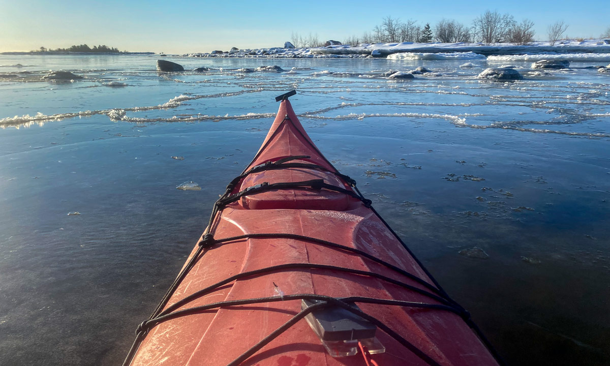

As you can see it had snowed a bit between these two tours.
The day before yesterday I just wanted to circumnavigate the small islet Lillskär, but there was too much ice to cross and crossing ice with a kayak takes time. And since I work full time, time is limited. So I just paddled around a bit and then back.


Due to the frosty temperatures the ice was thicker today though hardly more extended. I started at the same place but then continued to the island Bredskär. From there I wanted to circumnavigate the island Bredskärssten, but the same story as two days before: At the northern shore of the island there was an ice field. Crossing it would have taken too much time so I changed my plans and made a smaller tour. Nice to be outdoors anyhow!


How do you cross ice with a kayak? If the ice is safe, just walk. You wear a drysuit and have your safety equipment with you, don’t you!? If the ice is very thin, just paddle through (use your cheapest paddle). But if the ice is between 1–2 cm, the ice may not bear you and you cannot use the blades of the paddle neither.
Then you can use isdubbar – part of the ice safety equipment. With these ice claws it is possible to pull yourself forward while sitting in the kayak.

If you are lucky the ice is thick enough to let the kayak glide over it quite fast. If you are less lucky the kayak will constantly break though and then it can be pretty exhausting, especially when the ice claws break the ice as well. Then it is sometimes simpler to pull yourself forward by grabbing the ice with your hands. Waterproof gloves or mittens strongly recommended!

Just 14 km by car to the parking place on Kvaløya and I’m at the southern end of the two valleys Finnvikdalen and Krabbelvdalen. I put on the skis, put on the backpack, up with the hood and I’m ready to ski. -14 °C, hardly any wind.


First I follow an old track, perhaps two skiers and two with snowshoes went there. But soon I leave it to follow the Krabbelvdalen. Further plans: none yet.
Slowly the terrain rises. I do not have climbing skins with me but mostly I can ski just straight ahead. I’m alone and leave a track in yesterday’s freshly fallen snow.

I spot a cabin by a mountain slope and realise that the mountains may be not as steep as they looked first. Could it be possible for me to ski over the saddle between the two summits of the Mellaskarfjellet (301 m and 325 m) to make a round trip? Well, at least I can try. To gain height I have to go zigzag a lot and some of the snow is hard and icy. I’m a lousy skier and wonder if I ever will be able to ski downhills and leave this place. Well, I reach the saddle and it’s only 40 more metres in altitude to the southern top. Let’s go and make the round trip a topptur – a summit tour.
To make a long zig-zag story short: I reach it! I put on my down jacket and take a rest with a bit of chocolate and half frozen water.


The descent to the Finnvikdalen takes some time. I do not dare to ski straight downhills because parts of the snow are icy and other parts is crusted powder snow where you break though. So I take it slow and easy.
I see two other skiers with a dog approaching. While I slowly ski downhills they catch up and thank me for the track I made while passing.
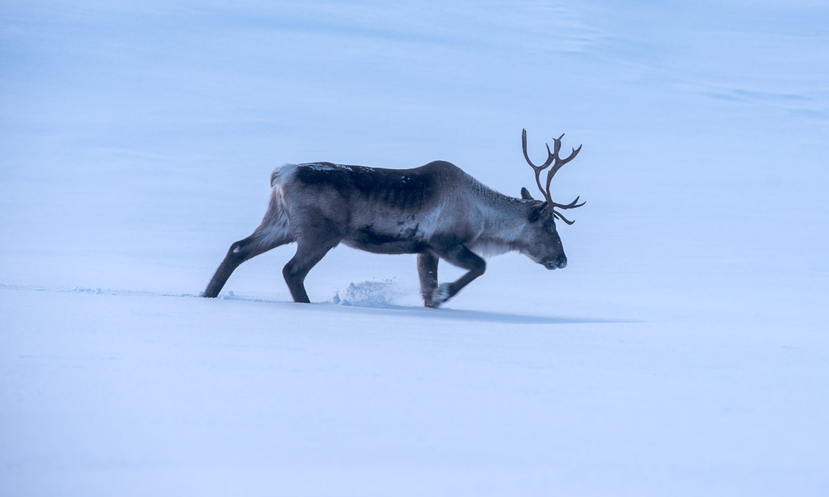
Two reindeer nibble at the birch trees, I’ll never will understand how they can survive cold winters with this nutrition. The dog is quite interested. “Will is run? Is it fun?”. But alas it is on a leash and the reindeer calmly trots through the snow to find another birch to nibble at.
Now it is me who is the lucky one. The dog owners leave a fresh ski track on which I at least double my tempo. They head to something that looks like a broader ski track and so it it. It leads to a mountain hut.


![]() A lot of skiers are on this trail. After I have passed the hut I’m on a broad trail prepared by a snow mobile. Now I can ski even faster (still slow ;-) ) but I’m unsure where this trail leads me. I continue following it constantly checking my map app until it signals that I’m on my old track again. What? Where? Here? I do not recognise this place!
A lot of skiers are on this trail. After I have passed the hut I’m on a broad trail prepared by a snow mobile. Now I can ski even faster (still slow ;-) ) but I’m unsure where this trail leads me. I continue following it constantly checking my map app until it signals that I’m on my old track again. What? Where? Here? I do not recognise this place!
Some hours ago I was alone, now a broad track cuts through the landscape. I pass the very same tree that I photographed this morning. Ok, the app is right. The parking place comes into sight, it is full of cars. Just a bit more to go and I arrive at my car. While I stop my tracking app and change my clothes other people pass me on both sides.
I guess many Norwegians would just laugh about me calling my today’s tour a topptur, since the summit is a hill, not a serious mountain. Many Norwegians are excellent skiers and topptur is used for alpine style tour skiing often in steep terrain, not necessarily for cross-country skiing . Anyhow I liked this tour and give it the name I think it deserves from my perspective.
On the map you can both see my zigzagging near the summit and that I was significantly faster on the trail back ( slow | fast).
To my big surprise it has become colder. -16 °C the car thermometer shows now. At home it is only -7 °C. I wonder why because both places are located quite near the sea.
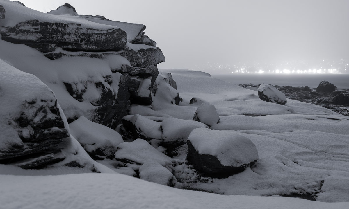
I couldn’t sleep. Not at all! At 1:30 I gave up and went out for a walk. And took some photos. Black and white. By the coast. Snow showers.

Now I try to catch some sleep. Good night!
____
Not I see, that the 2nd JPEG has quite strong colour artefacts. I may correct that. Later.