From autumn to winter – a tour to the Litjeblåmannen

This article is part of the series “2021-07: Back in Tromsø”.

My first concert with the chamber choir Ultima Thule was supposed to be today but due to the increasing COVID-19 cases in Tromsø the board decided to cancel the concert. That’s a pity but gave me a free day and the opportunity to continue with my #onceaweek project. I decided for a tour to the Litjeblåmannen (860 metres above sea level).

At 8:40 I have parked my car and start the tour. Temperature is -5 °C. Brr! I regret that I left my long johns home. That changes quickly when I take the first steep climb up the forest path and start to sweat. All trees have shed their leaves and are bare.

At 8:40 is sunrise. Half an hour later I can see the sun rise above the mountains. Ten minutes later I have left the birches behind and the landscape opens. I am gaining altitude and soon the path starts to cross the first snow fields.

Ten other minutes later snow and rocks start to dominate the landscape. It looks like winter. The autumn is left behind in the valley. I see a radio mast, part of the radio station on the Rundfjellet (472 m). Well, that was easy.

I decide to continue the tour. But where? The tour description mentions that I have to go down 50 metres. I hardly see any waymarks or a track but soon some foot steps that I follow. According to map and compass it’s the right direction. The terrain gets rockier, steeper and is partly icy but at least I spot some waymarks again. I stop to strap my spikes under the boots. Safety first! Less than an hour later I pass another radio station. I do not look closer because the terrain behind the building is very steep.

The terrain continues being steep and rocky but after a while I reach a plateau. Now it’s winter. Beside of some tufts of grass covered with frost there’s only snow and rocks.

From now on it’s much simpler to walk on this snow covered plateau and soon I reach the mountain summit Botnfjellet (844 m).

That’s however not my destination. Well, the summit of Litjeblåmannen looks far away but it takes only 20 more minutes to go there.

Break! Summit selfie!

The fur hood is not only for looking wintry on the selfie. It was colder than expected and after the selfies I put on my down pullover. Checking the temperature at Tromsø airport and subtracting 0.6 °C per 100 metres altitude I guess that the temperature is round -7 °C. The wind makes my mind change about wearing long johns a second time.

I eat a bit of chocolate and drink some Sprite before the frost transformed it into slush. I’m completely alone and I haven’t met anyone yet. It’s just beautiful up here with views on snowy mountain chains everywhere but on the snowless lowlands and the fjords as well.

After 20 minutes break I start my way down. First I follow my own tracks until I met the first mountain hiker today. Now I follow her steps. Does she know a better way?

Some impressions from the way down:

While I descend more and more the sun starts to set. I hike cross-country. Less and less snow covers the ground until I reach a terrain consisting of terraces of wetlands and dense birch thickets. The wetlands are easy to cross, since the ground is mostly frozen and I have rubber boots. The birch thickets however take some time to squeeze through. Looking back I can see purple clouds indicating that the sun already has set.

At 14:40 I arrive at the car. -4 °C. According to my app I walked 15 km and 1120 metres in altitude. I started before sunrise and arrived after sunset. This gives me the right to be very lazy the rest of the day. The blog article I want to write anyhow.

I met three persons in total:

  • A woman in my age in clothes that probably have been used on countless tours for many years,
  • A young woman in a grey woollen sweater hiking up quite fast while talking loudly on her cell phone.
  • A packed sleeping bag on a stone in the wetlands. A sleeping bag with a book. Wait! No, it’s a hood with a book. Wait! No, it’s a person leaning against a large rock reading. In the middle of some wet slope on the island Kvaløya. People here really like being outdoors.

So much for today. And now I have to stretch!

Appendix:

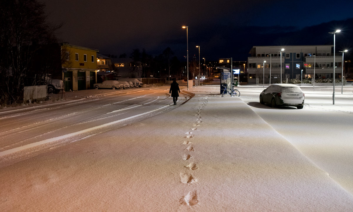
I just went to the kitchen and felt, that the outside light had changed. It had! It had snowed some centimetres and is still snowing. Everything is white. Beautiful!

After autumn comes winter?

This article is part of the series “2021-07: Back in Tromsø”.

Two days ago I took a promenade to take some autumn photos. I soon broke of the walk because the asphalt was partly frozen and slippery as hell. It was a mistake to leave my spikes home.

On my mountain tour yesterday I both experienced autumnal and wintry conditions. And I had spikes for my boots with me. While I had been writing the blog article yesterday it had started snowing and that’s how it looked today.

My first snow in Tromsø this season. Yay! 8–10 cm had fallen and while I walked to work it started to snow again. Temperature was below zero and the snow was fluffy. It was fun to walk in the snow.

Looks like winter, doesn’t it? But if the forecast is right it will get warmer again already tomorrow afternoon and rain a lot in the night. A short pleasure.

Tønsnesvarden

On Tuesday we got some snow in Tromsø. On Wednesday it already has melted away. But last night a bit of snow arrived.

Today I chose a shorter tour from my book “På tur in Tromsø” (On tour in Tromsø) because I just wanted an easy hike, not a full-grown mountain tour. The weather agreed with me.

By the sea only a bit of wet snow and sleet covered the ground but already 50 meter higher the gravel path was covered with 10 cm of snow. Deep tyre tracks were carved in the snow. This part of the tour was very easy. Just follow the road up until you reach the radio unit on the Tønsnesvarden (281 m) and try not to slip, because under the snow there are some icy patches.

This summit has a big radio station on its top. Even in the increasing snow fall is was quite visible. Now I walked through 20 cm of snow. After an hour I arrived at the radio station, where I met the creator of the deep tyre tracks: A six-wheeled ATV.

It wasn’t cold but a windy. It snowed more and more and the wet snow glued itself to my jacket. On my way back I left the main road and followed a small path on my digital map on my iPhone. I stopped in a forest of birches with thin and long stems. I loved the motive, but my Nikon camera gave up in this wet weather. The lens was fogged up in the inside and in the dense and wet snowfall I didn’t dare to change lens. One photo worked out ok anyhow:

Soon I realised that some of the paths drawn on the map did not exist in reality (at least not in winter) while others that exist were not part of the map. So I went cross-county through pathless terrain, partly dens forest, partly wetlands with many small streams to cross. It took only 15 minutes until I reached the other gravel road leading down again. Now the iPhone was in charge for making pictures.

I followed the path down. With each metre altitude I lost there was less snow on the ground and the snow fall became more and more sleet. When I arrived at my car my anorak was soaking wet. Having seat warmers in a car is a great feature after such a tour.

For the records: 6.5 km, round 300 metres in altitude. Temperature round 0°C.

Appendix 1:

When I show pictures of mountain tours and hilly hikes it is easy to forgot, that Norway has not only mountains but the sea, too. This is an iPhone snapshot I took from some metres from my parked car. What you cannot see is the mountains of the island Kvaløya, 3.8 km away. They are hidden in the snow clouds.

Appendix 2:

What do you do with photos taken with a fogged up lens? You start to experiment. I mean, the photo is spoiled anyhow. But the result of today’s experimentation turned out nice in my opinion.

Hiking up the Grønnlibruna

Here I stand on top of the small mountain Grønnlibruna (401 m).

I crossed a river and followed a forest trail that sent me deep into the mud. I trudged through knee deep powder snow and then stalked through Styrofoam-like wind-pressed snow to reach the summit and see the mountains in the sun that yr forecasted. Here I stand on top of the small mountain Grønnlibruna and there is no sun. It is snowing. It has been snowing all day and the mountains are hidden by the clouds.

As yesterday I am alone. Apparently the locals do other things in November than hiking up snowy mountains. While I walk around on the plateau of the Grønnlibruna the weather is changing and slowly the mountain ranges come in view and so the bay Sørbotn and the island Håkøya. The sun however I do not see today.

The last photo is taken with my Nikon, the others are edited iPhone snapshots.

For the records: 8 km there and back. Round 400 m in Altitude. Temperature -1 °C … -5 °C. Next time: snow shoes.

Apropos next time: Today we had 4¼ hours of daylight. Next Sunday it will be 2¾ hours. Saturday after that 13 minutes. On Sunday in two weeks we will have polar night in Tromsø until 14 January 2022.

So next time I’ll not only take snow shoes with me but some powerful headlamps, too.


Not reaching the top of the Nordtinden

Today I hiked the last daylight tour this season. Next Saturday sunrise is 11:25 and sunset is 11:38. The following day a seven week period of polar night will begin.

I wanted to hike onto the top of the Nordtinden (640 m), which I assumed to have a lot of snow after last Sunday’s experience. But it turned out different than planned.

Let’s start with a funny selfie:

What’s that? Winter jacket and no snow? Aren’t you overdressed, Olaf? Well, first I was glad about the fur-rimmed hood, because it was quite stormy already in the lowlands and then I wanted to gain 600 metres in altitude. It would be colder and windier on the top of the mountain.

Part 1 – hiking the icy gravel road

At 9 o’clock – round one hour before sunrise – I parked my car in Skulsfjord on the island Kvaløya. There was enough light to start the tour. First I followed a gravel road for 2.4 km. Easy peasy when not the whole road had been covered with ice. I had snow shoes with me for later use, but no spikes for the shoes. Mistake.

Part 2 – following the trail up

After 2.4 km I turned left to follow the hiking trail up to the mountain Nordtinden. Well, mostly I avoided following it because it was very icy and slippery. I considered cancelling the tour but often I could walk on the bouncy patches of heather beside the trail and so continue the tour.

Part 3 – gaining height

A steep passage made me doubt again. Shall I return? Continue? Well, let’s go a tiny bit further, just ten other metres up. I was lucky. Now the terrain was less steep. First only a bit of snow covered the stones and the heather but soon more and more snow covered the ground.

Part 4 – coming to a dead end

I knew that I lost the regular way. The way itself was not visible anymore, but I could see on my interactive map that I was a bit lower than the trail. Maybe I could go up somewhere else.

It was stormy and gusty and the wind tried to blow me down several times. The snow was not fluffy but wind pressed and hard and therefore slippery. When I had to traverse a slope I mounted my snowshoes. It took a while because I had some issues with the bindings. Now it dared to traverse the snow field, but since I didn’t take my walking sticks with me (mistake) it was a bit hard to walk up in the wind and gain balance.

And then I came to a dead end. A quite beautiful dead end, but still a dead end. I had to return.

Part 5 – returning, retrying and finally returning

So I walked back until I finally met the trail again, at least according my iPhone map. The way itself was hidden under the snow. Beside of that Norwegian hiking trails can be marked quite poorly, you have to navigate by yourself.

OK, I can navigate. I even had paper map and compass with me. But where the trail supposed to be there were only snow and rocks. And it was quite steep. And the snowshoes were a bit bitchy. And sun would set at 13 o’clock. Therefore I made the decision to not to try to reach the summit but abandon the tour and return. And so I did.

First I walked on snow but then I had to put off my snowshoes. In the lower part I ignored the icy trail and walked down on the heather. Much easier! Three and a half hours later I arrived at my parked car.

Résumé

It was a pity that I didn’t reach the top, but it was a fine though rough tour anyhow. From next week I have to find alternatives that are doable in twilight and darkness using a head torch.

For the records: 9.6 km, ca. 600 metres in altitude.

No whales today

To the left the Brim Explorer, a boat located in Tromsø for amongst other whale watching. To the right the tourists waiting to be boarded. The boat is fully booked, I am not alone.

Before leaving an announcement: The crew will try its best but it’s not granted that we reach the waters where the whales are. Anyone is free to leave and given a full refund. Most people stay and so do I. First of all I’m not surprised, as another tour operator already cancelled today’s tour. And then I just want to be a day on the water. Whales of course would be a nice extra.

To the left Tromsøbrua, the bridge that connects Tromsø with the mainland. To the right the safety on board drill, that everyone had to join.

And then we’re off.

To make it short: What we didn’t get today was whale sightings. What we got today was rough weather in the open parts. The boat was rolling and pitching like a cork in the waves. More than one passenger got sea sick. The unpredictable movements of the boat and the dim light under the grey sky made photographing a bit adventurous. Several times I was forced in and one passage even the doors were locked. The rest I was outside, partly taking photos, partly just looking around and letting the wind blow around my nose.

Conclusion: an awesome tour even without whales. If you want to participate as well: take your warmest clothes with you. And those of you that just want to stay home and look at some whale photos may read my article about Whale watching in Andenes. Enjoy.

Note to myself: TromsøyaRingvassøya/ReinøyaVannøyaNordfugløyaArnøya/LaukøyaSkervøya/KågenLyngenReinøyaTromsøya

Whale watching – second try

Yesterday Same meeting point, same tour, same boat as 6 days before. But completely different weather! No stormy wind from the north and clouds everywhere, but a clear and starry sky.

And off we went.

It was just incredible how much brighter everything was although it was less daylight than last Sunday. After two hours the island Nordfugløya came into view. A cloud parked itself over the island.

Slowly the colours of the sky intensified and remained colourful the whole short day, because now it was the first day of polar night¹.

It took us round 3½ hours to reach our destination, the sea round Skjervøy. So we had only limited time before we headed back. Already at one, half past one o’clock it started getting darker again.

Eight hours after our departure we had returned to Tromsø.

I have been outside for round seven hours. I didn’t freeze because I was wearing my warmest winter parka. I was inside once to eat a bowl of soup and once when I stood at the ship’s bow and the sea spray soaked the whole foredeck (including me). So I was eager to take a shower not because of being cold but I wanted to get rid of the salt hands and face were covered with.

Resumé: It was a great boat tour and I enjoyed the air, the colours, the light.

And the whales? Oh yes, the whales! Almost forgot them ;-) Well, we saw some of them, mostly orcas and the first fin whale of the season. There were not many whales around and they were quite in a distance, so for photographing whales this tour was not ideal. Too little time and too high the boat decks above the water. I would love to paddle kayak there but I’m pretty sure that I never ever will dare to do that.

____

¹ Where I live in Tromsø we technically had 14 minutes of daylight yesterday but already 1.3 km north it was the first day of polar night.


It gets dark – it gets bright

This weekend the mørketid started in Tromsø. That’s the time when the sun does not rise above the horizon any longer. Literally translated it means “darkness time” but usually it is called polar night.

What do you do if it gets darker? You illuminate the town!

Have a look at the photo with the two deer. You see the red-white logo with the H to the left? That’s the Hurtigruten ship MS Nordlys. You see the lights above amidst the darkness? That’s the mountain station of the Fjellheisen cable car on the other side of the Tromsø sound.

Why I was in town and not on tour? Because today was the Christmas tree lighting in the center of Tromsø and I was singing there as part of the chamber choir Ultima Thule. The place was crowded with people that wanted to experience this annual tradition. Here’s a snapshot that I took from stage during the soundcheck:

Unfortunately there were many people that did not wear a mask. Please cross your fingers, that this event does not lead to another increase of Corona here in Tromsø.

Polar light at Tuesday night.

Thanks to a phone conversation with my wife Annika I was wandering around the apartment in Tromsø. I watched Orion rise behind the mountains and a faint something above. The something was a weak polar light. Within short time the aurora intensified and while I was walking to the shore I could see it moving over the whole celestial sphere. When I arrived at the shore some minutes later it already had weakened a lot (so typical!) and the violet parts were gone. Anyhow it was still a beautiful polar light worth being photographed.