Grense Jakobselv

This article is part of the series “2021-08: Northern Norway”.

This sign marks the only Russian–Norwegian border station. In February 2018 I crossed this border to Russia together with Annika and two friends. This time we stay in Norway and I take just a photo of the sign.

Our destination today (which is 30 August): Grense Jakobselv, a small border village. As the road to Hamningberg the road there is opened only in summertime and we never have been there before.

It starts like a typical car trip. The road goes along the Jarfjorden and a large lake. In Vintervollen the road turns right and we see the barrier that closes the road in winter. It is open. Now the road leads over the mountains. The rocks here are the oldest in Norway with an average age of 2.9 billion years. I’m not a rock expert and so I take a photo of a birch instead of a random rock whose type and age I cannot determine.

We reach the small river Jakobselva. This small and shallow river is special because here it marks the Norwegian–Russian border. The pink salmon (also called humpback salmon) do not care, they are busy to go upstreams and not all fish succeed.

We continue to the village Grense Jakobselv. For me the biggest surprise was the chapel. In my view every northern Norwegian church is made of wood and painted white. Not the King Oscar II Chapel (built 1869) that is made of stone.

While I wasn’t properly prepared about the church I knew something else: There is a sandy beach. It is at the very end of the road. Annika and I take a bath. Water temperature is about 11–12 °C. It feels quite strange to change clothes for a bath while you can hear the Norwegian army practising shooting.

As many minor roads in northern Norway the road to Grense Jakobselv is a dead-end road and so we have to drive the very same road back. After having been back we get something we have missed on the journey so far: an afternoon nap!

Boarding the MS Lofoten

This article is part of the series “2019-02: Northern Norway”.

After some days in Bjørnevatn near Kirkenes I start my journey home today. But I’ll take a long, long detour!

Some hours ago I boarded the Hurtigruten ship MS Lofoten. It’s both the oldest and the smallest of the ships that serve the coastal route BergenKirkenes. It was built 1964 and is therefore older than me. It can accommodate 153 passengers.

I will travel four days and leave the MS Lofoten in Trondheim where I hope to catch the train back to Sweden. I already bought WiFi access for the next four days and found a nice place for blogging.

Here are the stopovers of the next four days:

Kirkenes – Vardø – Båtsfjord – Berlevåg – Mehamn – Kjøllefjord – Honningsvåg – Havøysund – Hammerfest – Øksfjord – Skjervøy – Tromsø – Finnsnes – Harstad – Risøyhamn – Sortland – Stokmarknes – Svolvær – Stamsund – Bodø – Ørnes – Nesna – Sandnessjøen – Brønnøysund – Rørvik – Trondheim

Inside the Snowhotel Kirkenes

This article is part of the series “2019-02: Northern Norway”.

After two great snowshoes tours I took it easy today. I went to the Snowhotel Kirkenes nearby, took some photos of the huskies, that didn’t have to work, visited an acquaintance who works in one of the restaurants and went inside the Snowhotel itself. I’ve been there before, but since the hotel is rebuild from scratch every year it looks always different.

Which photo of the lobby do you prefer? The first one, where the room is empty or the last one with the blurred people in it?

A lake named after Anders

This article is part of the series “2019-02: Northern Norway”.

Ascending and descending hills and mountains and three selfies at three different places

The forecast was right, today it was sunny. Morning temperatures were round -9 °C – good conditions for another snowshoe tour.

Chris gave me some tour tips and I decided to go south to a nameless hilltop. I crossed the road and followed the snowmobile trail that cross the river Katojoki. To be honest, without having looked on the map before I hadn’t realised that it was a river. Now I put on my snowshoes and left the trail.

It was quite exhausting to walk through the snow because even with snowshoes I sank 20 – 40 cm into the snow with each step. Snow was falling on top of the snowshoes giving them additional weight. The terrain was rising and I had to make several short breaks to catch my breath. When I came near the hill, it got steeper but since the hill is only 151 meters above see level I was soon on the summit, a snowy platform with a 360 degree view. Here I took a break.

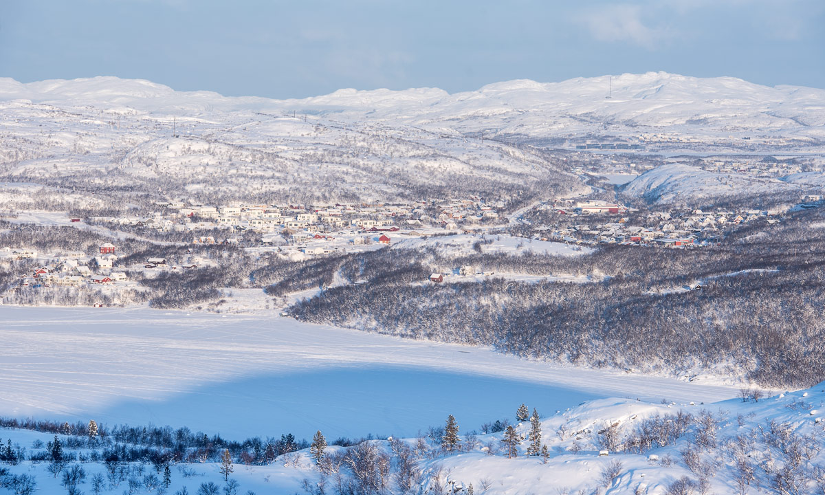
To the north I could see the small town Bjørnevatn and snowy mountains at the horizon. To the east I could see the Fjord Uhcavuotna or Langfjorden. On the snow covered frozen fjord I watched the snowmobile groups and the dogsleds. It’s high season for tourists. Looking to the south I saw the fjord disappearing in the fog. In the colours of the still low sun the scenery looked quite unreal.

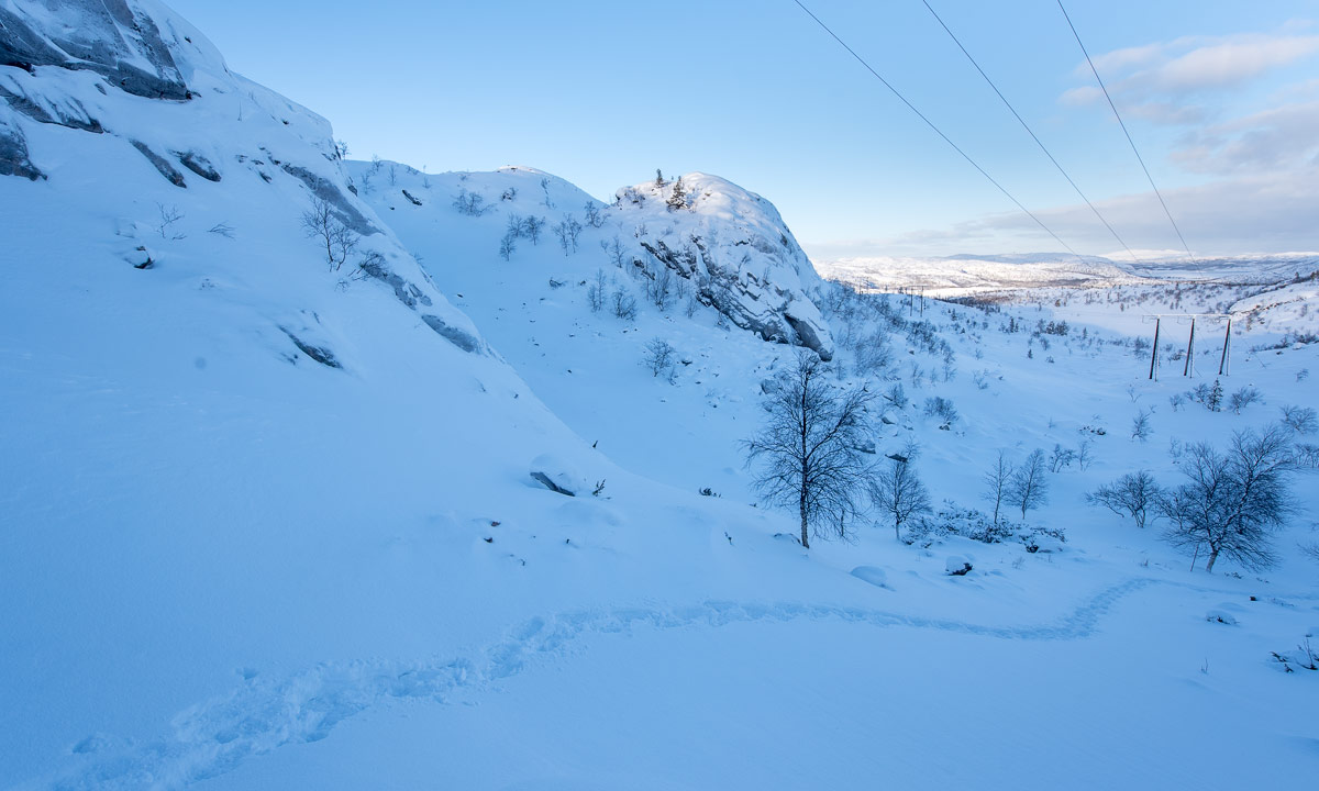
It was half past ten. Definitely too early to return. In the southwest I spotted a higher mountain range, which I already knew from the map. Between the mountain range and my resting place on the hilltop there was a valley. I wasn’t sure if I would manage to climb the mountain range but I could try. I zigzagged down the hill to avoid the steeper parts, crossed the valley – phew, deep snow again – and went up a small snowy hill.

You see the picture above? There are two possible ways up the mountains. A steeper and higher one to the right and a shorter and less steep one to the left. The right one could be too steep for me and my snowshoes and I was afraid of avalanches. Therefore I chose the left one. It worked! After ascending the snowy slope I stood on a small plateau.

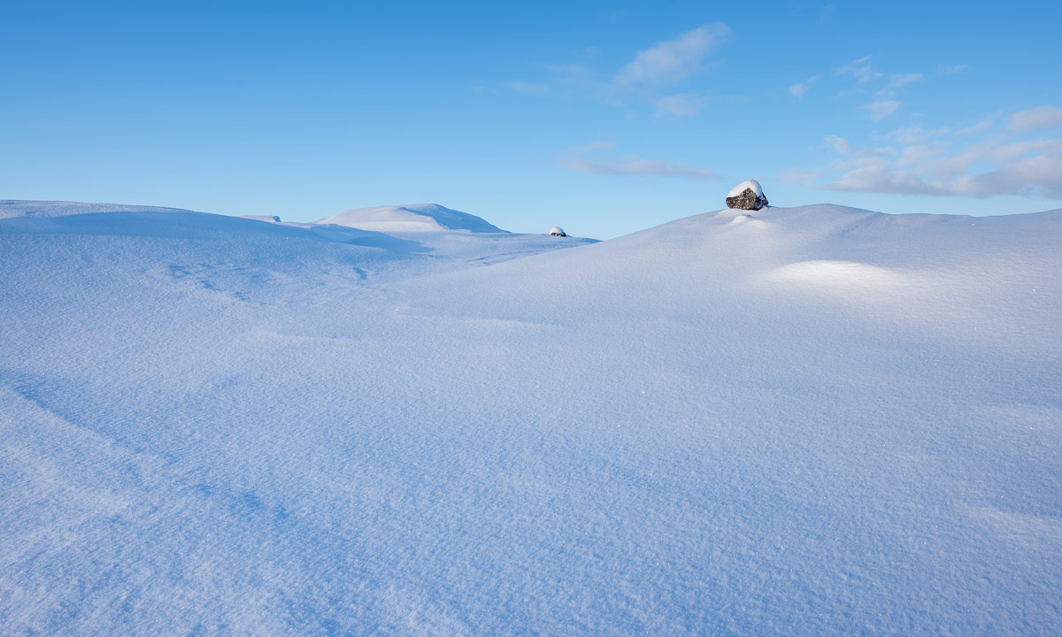
I had to climb another slope, shorter but steeper, then I reached the sunny vidda. Vidde is Norwegian for expanse and for plateau or tableland. You may know the word from Hardangarvidda, a large plateau between Bergen and Oslo.

That’s the landscapes I love – less is more!

After walking around and going up another small top I reached a flat snowy plane. If it’s completely flat it’s probably not a bog but a lake and so it was. It was the lake Andersvatnet (136 m above sea level).

On the other side another hilltop, according to the digital map 183 m above sea level. Strange that all these summits and tops do not have any names, at least not in the official maps. I decided to climb this top, too. The borrowed snowshoes are not very good for steeper passages so I had to look for a good way up and more than once I slid back or had to use my hands to pull me up. But finally I “conquered this hostile mountain”!

The first photo above shows Andersvatnet. If you look at the enlarged picture you can see my snowshoe tracks.

I didn’t make a long break because I wasn’t sure about the continuation of my tour. I would love to stay up for a while and then descend at another place, but according to the map it could be quite steep. I went northwest and went along the edge of the mountain range.

I looked for a possibility to descend the plateau but finally I had to realise that all slopes were much too steep to descend. Therefore I continued by circular route until I could see the same power pole again that I passed on my way up. I ascended another small top, again with a gorgeous view. Time for another break.

I felt cold. Probably it was because I was exhausted and a bit sweaty. While I didn’t close the down parka at all at my first break I closed it completely this time and even put on the woollen mittens. Wrapped up like this I could enjoy the sun and the views in all directions. But then it was time to continue the tour and to leave the bare mountains. I found my old snowshoe tracks, followed them and went down, mostly in my own tracks.

After I left these mountains behind I went back straight ahead. Again deep snow, but less exhausting than climbing all hilltops. I was back to civilisation. I could hear the roaring of the snowmobiles and the barking of the huskies. Later I saw them both. A group of white dressed snowmobilers – probably hunters – and the huskies pulling the dogsleds. Still I was 100 meters above sea level – high enough to have wide views. Do you see the dogsled on the next photo?

I reached a large trail prepared for the dogs. It was solid enough that I could go there without snowshoes. What a blessing! Snowshoes are great for mountain tours like today but I always feel clumsy wearing them. I passed some dog teams – guides sorting the dogs and tourists wrapped in winter coveralls sitting in the sleds or taking pictures.

The inner of my nose started to tickle, normally a sign that it’s -15 °C or below because then the nose hairs start freezing. Even my eyelids started to freeze together. When I arrived home the thermometer showed -16 °C. So it has become colder over the day.

Now it’s 22:15 and outdoor temperature has dropped to -22 °C. Probably the last cold night for a long time, since much warmer weather is on its way.


A snowshoe tour over the snaufjell

This article is part of the series “2019-02: Northern Norway”.

After some very lazy days I decided to make a snowshoe tour today. I just had to move! I’m here without my own car and therefore with quite limited baggage, but I was lucky to be able to get snowshoes from the Snowhotel Kirkenes.

First I followed a marked snowshoe route. It was -8 °C and in contradiction to the forecast the sun was shining. After some time I left the trampled path and made my own tracks. That’s what snowshoes are made for.

I went around and up some of the higher hills. First I love the view and then I love the snaufjell, the part of the mountains above the treeline. In Swedish it is called kalfjäll, but both words mean the same: bare fell. And soon I got my views.

One thing is special: There are boulders everywhere. I guess it’s leftovers from the last ice age but I don’t know why you hardly find those round-shaped boulders at other places on the bare fell.

The sun had vanished behind a layer of clouds and it started to snow. Sometimes the snow underneath my feet was of such a perfect white that I could not see whether it was going up or down. At least the sight was good and the terrain is easily accessible.

I navigated only by sight, therefore I cannot give you the name of the mountain top that was marked with a pile of stones and a wooden stick.

After some time I started my way back and descended from the snaufjell until trees got more common again.

I walked down through the fresh white snow – sometimes knee deep even with snowshoes – until I came to the trampled path again. Here the snow was so firm that I unmounted the snowshoes and went the rest of the tour without. Three hours later I was back in my host’s house.

It doesn’t happen often that I have a clear photo favourite of a certain day. Today I have:

Going by snowcat

This article is part of the series “2019-02: Northern Norway”.

It’s dark outside. I’m in the cozy house, where Chris and Ørjan live and reading. But what’s that blinking orange light outside? I peek through the door and what I see is a snowcat.

Ørjan is about to start a tour to prepare trails, both for his employer, the Snowhotel Kirkenes and for the local skiers. Preparing trails for the latter is a dugnad, that means voluntary work. Dugnad is very popular in Norway.

I ask Ørjan if I could join him on the tour and I am allowed to. Time to take some handheld pictures.

It’s fun to go by snowcat through the dark. I looks quite easy to operate and I would like to have my own snowcat. But neither do I need one nor could I pay it.

Takk for turen, Ørjan!

MS Spitsbergen

This article is part of the series “2019-02: Northern Norway”.

Today it was cloudy and much warmer in Bjørnevatn than yesterday day and evening. Chris and I took breakfast at the Thon Hotel Kirkenes. This breakfast is just superb! There is a wide variety of food and the quality is excellent. While we had breakfast it started snowing. I looked out of the window and watched a small icebreaker. Two years ago the Elvenesfjorden was completely free of ice. This year however it had been so cold the last weeks that the whole fjord is frozen. Or would be, if the icebreaker wasn’t going back and forth and crushed the ice.

Kirkenes is the endpoint of the Hurtigruten line, that connects many Norwegian coastal towns as e.g. Bergen, Trondheim, Bodø, Tromsø, Hammerfest and Kirkenes. As long as the weather allows the ship arrives at 9:00 and departs at 12:30 every day. Many tourist go ashore to discover the city or to go dog sledding in the Snow Hotel.

Today it was the MS Spitsbergen that was in the harbour. It is possible to visit the ships and so Chris and I took a small tour to explore the ship.

The MS Spitsbergen both operates the Hurtigruten line Bergen—Kirkenes but also makes cruises to places like Iceland (from 4373 EUR), Svalbard (from 7058 EUR) or even Franz Josef Land in Russia (from 7696 EUR). Great destinations but much too expensive for me.

P.S.: Don’t ask me why there is dried fish on the top deck of the MS Spitsbergen.

Light pillars and northern lights in Bjørnevatn

This article is part of the series “2019-02: Northern Norway”.

I have seen light pillars in my life and I have seen the aurora many times. Today I got the perfect combination of these two light effects. And never ever saw I light pillars as clear as today.

To see light pillars you need cold weather. When I was out, it was between -22 °C and -24 °C, probably colder on the frozen fjord. Light pillars are caused by hexagonal ice plates that tend to hover horizontally and therefore reflecting the light vertically. The light source can by natural, as e.g. sun and moon or artificial.

I was very lucky that it was cold and clear today so that I could observe them and make some pictures.