Happy New Year 2022

Some photos from New Year’s ski promenade with friends. We were lucky – clear sky and -12 °C gave perfect conditions for some outdoor BBQ at Stora Stenen. And when the wind increased we went inside the wooden cabin of this public recreation area and fired the oven.

Have a Happy New Year 2022 all together!

Kayak and ice on the Baltic Sea

Does it work? Can I paddle kayak on the Baltic Sea when it is covered with up to 20 cm thick ice floes?

Well, let’s try …

Looks like it worked, doesn’t it?

Well, to be honest, no it didn’t.

I did not use the paddle at all but just pushed myself forward with my arms and so pushed the kayak over the ice floes. Since this was slow and exhausting and I only had my lunch break I did not come far and did not reach the open sea that always was in view.

And the way back? The same but backwards. I don’t think it would have been possible to turn around the kayak in the ice. while sitting in it. But it was fun anyhow.

Four winter days in and round Obbola

OK guys, it’s Sunday afternoon and I’m too lazy to write long texts. I just show some photos of the last days where our German friend Medi joined Annika and me on various excursions with some notes.

Thursday, 6 January – skiing in Västermarks naturreservat

+++ Västermarks naturreservat, 50 km north from Umeå +++ a non-commercial forest made us climb over and under fallen trees that lay across the marked loop trail +++ by the trail a wooden cabin +++ time was too short to fire the oven but lighting candles is cozy, too +++

Friday, 7. January – lunch break skiing

+++ right next to our postbox (500 metres from our house) starts Spåret, a 3600 metre long forest trail +++ we use back-country skis to ski Spåret in my prolonged lunch break +++ we, that’s Dirk – guest for two nights – Medi and I +++ -12 °C, but my Anorak is too warm +++ I tie it round my hip +++ on the photo it looks like a skirt +++

Photo: Dirk Thomas

Me sking “Spåret” – Photo: Dirk Thomas

Saturday, 8 January — cross-country skiing on Olle’s Spår

+++ grey weather, -14 °C +++ the trees are covered with snow +++ black-and-white imagery +++ after some days of back-country skiing it’s nice to use cross-country skis on a real trail +++

Sunday, 9 January – Northern lights and sunrise

+++ 1 o’clock in the night +++ I check for Northern lights +++ we are lucky +++ Medi and Annika watch the aurora beside of the garage +++ I take some photos from our garden +++
+++ 8:20 in the morning +++ the Baltic Sea freezes over more and more +++ sunrise colours by the sea  +++ and then in our garden +++ watching sunrise while taking breakfast +++

Still Sunday, 9 January – Strömbäck-Kont

+++ just a short walk at one of Annika’s and my favourite places: Strömbäck-Kont +++ looking at the ice ridge by the sea +++

Still Sunday, 9 January – halo effects

+++ after lunch we are taking Medi to the airport +++ strong and colourful parhelion or sun dogs halos +++ the photo is taken at the airport +++ I am questioned by the security and show the taken photos to prove I’m not a spy +++

The ice did not last long

The morning of 10 January is my the coldest this winter: -20.5 °C. A longer period of frost has frozen over the Baltic Sea earlier than usual. I stand at the shore by our house. Ice as long as I can see.

I follow the coastal line to take photos. Ice fog draws in.

When I return from my pre-work photo trip the temperature has risen to -15 °C and it gets warmer hour by hour. In the evening it’s only -3 °C and it has become stormy.

Two days later I’m out again. It thaws. The effects of the storm are visible: The wind pushed the ice shield ashore where the ice broke into countless pieces.

Movements at the horizon. Large waves roll along the sea and build an ice wall by the rocks south from the island Bredskärssten, 1300 metres from our house. I would love to take photos there but there’s no way for me to get there. It’s too windy for a hovercraft and I don’t own one. So I take mobile phone photos through my spotting scope.

The next day. Similar situation but now with the sun illuminating the splash that the waves throw at the ice walls. The thaw has melted the snow on the ice and made it wet. It twinkles and glistens in the sun. Beautiful to watch.

In the night it is stormy und gusty again.

14 January – the next day. As every day it is too dark in the morning to spot the sea. A small line of red at the horizon signalises the approaching sun. And there it is: 09:03 – sunrise.

Now I can see that beside of some leftovers by the shore all the sea ice has gone. Crushed by the waves and the storm and floated away. Now there’s open water from shore to horizon. Probably it will take some time until the Baltic Sea freezes over again.

And what can you do in open water? Correct – you can kayak!

It was just a very small tour round Lillskär. First it was just a lunch break again and then it was still very windy. Wind came from west and I didn’t want to drift to Finland ;-)

Kayaking however wasn’t dangerous. It’s easy to paddle against the wind – easier than side winds – if the distance is not too big. Probably more dangerous is the large, wet patch of blank ice in front of our house. Slippery as hell! Hopefully it gets colder and snowier soon.

Link to a Swedish article of the SMHI: Bottenviken snabbt avtäckt igen.

Fresh snow in Tromsø

Since yesterday evening I am back in my “work town” Tromsø. How I got here after 17 hours of travelling is another story. I only mention that it among others had to do with snow.

And snow we got in Tromsø as well. Round 30 cm of fresh, clean snow cover the ground, the houses, the trees and build fields of slush in the shallow parts of the sea.

These photos are from a short promenade from Telegrafbukta and Sydspissen.

A winter journey from home to work

Last Saturday I travelled to work. ObbolaTromsø, that’s round 1000 km – the reason why I do not commute weekly.  This time it is a bit suspenseful, because there are two obstacles on my way.

One obstacle is easy: taking a covid test at the test center. The other is much bigger: The road over the Bjørnfjell – the only road – has been closed for many hours due to stow storm conditions. Well, I start my journey anyhow. We’ll see.

At 5:30 in the morning Annika takes me to the train station in Umeå. The first 9½ hours were just a “normal” train journey beside of the train being mostly ahead of time. One change in Boden – nothing special, just long and a bit boring.

I leave the train in Abisko Turiststation where I parked my car. My car – will I find it or is it submerged under a pile of snow? To my relief hardly any snow covers my car. I already hoped so, because Abisko is known for its low precipitation because mountains in the west protect it from bad weather. Much more snow and rain fall on the other side of the mountain range and that’s exactly where I have to go through. Some minutes after leaving Abisko behind it starts snowing. Snowfall increased more and more but isn’t severe and the Swedish mountain road is open. Soon I cross the Norwegian border and …

… have to stop because of a lowered tollgate with a red blinking light. Beside of two trucks I am alone. I am relaxed because I know that the road has been opened for driving in convoy one hour ago (thanks internet!). I just have to wait for the large snowplough to fetch us.

After twenty minutes the tollgate went up and the red light goes out. That’s all that happens. I hesitate. And now? Do I have to wait? Or may I drive? I don’t dare and ask one of the Norwegian truck drivers. He answers I should just go ahead and so I do. The drive is snowy but not bad and soon I arrive at Bjørnfjell brøytestasjonen where the snowploughs are located and now also the Covid19 registration. I register myself, get a covid test and start taking photos while waiting for the result.

I take an image of a snowed in car. The snow plough driver goes to me and asks for what purposes I take photos. “Just for my blog.” “Ah ok, just curious.” Good to talk to him, because so I learn that beside of the mountain passage behind Bjerkvik road conditions are good. Here they got a lot of snow the last 24 hours and one of the cars looks like this:

After round 20 minutes I get a ping ♪. It’s an SMS with a link to my test result. Negative :-). 260 km to go, that’s four hours when conditions were good.

The first 100 km the road conditions are good and weather is ok. The next photo shows how driving looks like.

The next hour it snows a lot. Sight is still good. To my left and right everything is covered with snow, from the largest church to the smallest branch of a tree. Winter wonderland.

Then it starts to get nasty. Snowfall intensifies more and more and the snow has the consistence of superglue. My windscreen wipers hardly manage to push away the gluey snow and finally I have to turn into a side road and de-ice the wipers. Scratch, scratch … . I’m not alone. In front of me a car with a driver doing the same. Behind me another car stops. Am I in the way? No, just another scratch, scratch. On the other side of the side road another one.

I still have some holes to peek through but it is extremely tiring to drive car through the night like that. Alas, after two hours I drive over the large concrete bridge Tromsøbrua and am on the island Tromsøya. Apparently Tromsø’s snow removal has given up. The minor roads are covered with 20 cm of snow with deep tyre tracks. I understand more and more why most Norwegians have cars with all-wheel drive (and so have I).

22:45. I make a last stop at the supermarket nearby that is open until 23:00. I’m lucky because Norwegian supermarkets close on Sundays. By the way: the supermarket’s parking place is in much better condition than the roads.

One other minute driving and I arrive at my flat in Tromsø after 17½ hours travelling. I’m tired but it takes another hour until I’m relaxed enough to sleep. Next week I’ll walk …

I walk to work

Back in Tromsø I decided to walk to work this week. 2½ km to the Norwegian Polar Institute in the Framsenteret and 2½ km back home. So I get at least a bit of motion each day. And a bit of outdoor feeling, too.

Monday, 17 January

It has snowed quite a bit the night and is still snowing. It’s -4 °C and the wind is calm. It’s fun to trudge through the powder snow.

Lunch time. We get the table by the panoramic window. Some boat owners clear the landing of the marina from snow.

Tuesday, 18 January

-3 °C and snow fall again but now the wind is stronger and squally. Luckily I have it in the back.

It gets warmer the whole day and it starts to rain. Wet ice and deep puddles on my way back.

Wednesday, 19 January

+2 °C, a bit of rain. Rubber boots, slush, ice, water puddles.

Thursday, 20 January

-1 °C and fresh snow.

I don’t trust the snow. I know that ice and slush lurk beneath the surface. Therefore I wear rubber boots again with attached spikes to avoid slipping on the wet ice. The gloves protect against the wind, the reflective wristbands with the blinking LEDs and the high visibility vest against not being seen by car drivers. No cyclists the last days.

Friday, 21 January

-6 °C, almost like winter. The canteen invites to “sun buns” and cacao because it is “soldagen”, the day where the sun is finally visible in Tromsø again after 8 weeks. Unfortunately clouds block the low hanging sun.

This weekend I won’t see the sun neither. We got warm weather and storm and unfortunately a lot of rain. So I’ll probably keep myself mostly inside.


I couldn’t sleep

I couldn’t sleep. Not at all! At 1:30 I gave up and went out for a walk. And took some photos. Black and white. By the coast. Snow showers.

Now I try to catch some sleep. Good night!

____

Not I see, that the 2nd JPEG has quite strong colour artefacts. I may correct that. Later.

January sun in Tromsø

After ten days with snow and wind, rain and storm and many, many clouds – there it is – the sun. The first time i see the sun in Tromsø since some day in November.

Photo taken with my iPhone through the window pane of the canteen at lunch break.


My first “topptur“

Just 14 km by car to the parking place on Kvaløya and I’m at the southern end of the two valleys Finnvikdalen and Krabbelvdalen. I put on the skis, put on the backpack, up with the hood and I’m ready to ski. -14 °C, hardly any wind.

First I follow an old track, perhaps two skiers and two with snowshoes went there. But soon I leave it to follow the Krabbelvdalen. Further plans: none yet.

Slowly the terrain rises. I do not have climbing skins with me but mostly I can ski just straight ahead. I’m alone and leave a track in yesterday’s freshly fallen snow.

I spot a cabin by a mountain slope and realise that the mountains may be not as steep as they looked first. Could it be possible for me to ski over the saddle between the two summits of the Mellaskarfjellet (301 m and 325 m) to make a round trip? Well, at least I can try. To gain height I have to go zigzag a lot and some of the snow is hard and icy. I’m a lousy skier and wonder if I ever will be able to ski downhills and leave this place. Well, I reach the saddle and it’s only 40 more metres in altitude to the southern top. Let’s go and make the round trip a topptur – a summit tour.

To make a long zig-zag story short: I reach it! I put on my down jacket and take a rest with a bit of chocolate and half frozen water.

The descent to the Finnvikdalen takes some time. I do not dare to ski straight downhills because parts of the snow are icy and other parts is crusted powder snow where you break though. So I take it slow and easy.

I see two other skiers with a dog approaching. While I slowly ski downhills they catch up and thank me for the track I made while passing.

Two reindeer nibble at the birch trees, I’ll never will understand how they can survive cold winters with this nutrition. The dog is quite interested. “Will is run? Is it fun?”. But alas it is on a leash and the reindeer calmly trots through the snow to find another birch to nibble at.

Now it is me who is the lucky one. The dog owners leave a fresh ski track on which I at least double my tempo. They head to something that looks like a broader ski track and so it it. It leads to a mountain hut.

Tracking map from my iPhone appA lot of skiers are on this trail. After I have passed the hut I’m on a broad trail prepared by a snow mobile. Now I can ski even faster (still slow ;-) ) but I’m unsure where this trail leads me. I continue following it constantly checking my map app until it signals that I’m on my old track again. What? Where? Here? I do not recognise this place!

Some hours ago I was alone, now a broad track cuts through the landscape. I pass the very same tree that I photographed this morning.  Ok, the app is right. The parking place comes into sight, it is full of cars. Just a bit more to go and I arrive at my car. While I stop my tracking app and change my clothes other people pass me on both sides.

I guess many Norwegians would just laugh about me calling my today’s tour a topptur, since the summit is a hill, not a serious mountain. Many Norwegians are excellent skiers and topptur is used for alpine style tour skiing often in steep terrain, not necessarily for cross-country skiing . Anyhow I liked this tour and give it the name I think it deserves from my perspective.

On the map you can both see my zigzagging near the summit and that I was significantly faster on the trail back ( slow | fast).

To my big surprise it has become colder. -16 °C the car thermometer shows now. At home it is only -7 °C. I wonder why because both places are located quite near the sea.

Oh, what a beautiful sunrise!

Mountains on Kvaløya photographed from Sydspissen, Tromsøya.

While the first images are made with a strong (though non-professional) telephoto lens (500–600 mm, ƒ/6.3), this gives a bit more impression of the mountains this morning:

Sea ice field work training – preparations

My job at the Norwegian Polar Institute is both to write applications and to manage scientific data. Since I’m not a scientist it’s hard to understand sometimes, how data is collected and digitalised.

To learn more about this I’ll participate a sea ice field work training tomorrow. It is organised by the polar institute and UiT, the Arctic University of Norway. We’ll be on the sea ice of Sørbotn – part of the fjord Ramfjorden the whole day and learn different measurement methods as coring and magna probe. (Don’t ask me any questions today. I hope I’ll know a bit more tomorrow.)

The instructors measured the ice depth yesterday. It is round 50 cm and absolutely safe to walk and work on. We had two preparative meetings where we discussed possible risks and how to dress properly. Although it is forecasted to be only -5 °C and hardly any wind it’s always good to have enough stuff to stay warm when being outside on the ice. I started packing today.

Some of the items I’ll take with me:

  • Thick Kamik rubber boots with inner shoe – really warm!
  • Red hard shell jacket and matching bibs. Not warm, but absolutely wind proof.
  • Grey down parka. For resting and having lunch outside.
  • The brown fur hat. 100% polyester, H&M, EUR 9.90. I used it once in -37 °C and although cheap it’s warm and works well.
  • Ski goggles – just in case.

The hard shell jacket and bibs are not mine. Yet. They belong to the polar institute and I got them recently. After five work years they are mine. The attached fur is my private one.

Maybe some of us will get a Regatta floatation suit, a warm, water- and windproof coverall, but I’m not sure yet so I’ll take all the private stuff with me. I love winter. I do not love freezing.

More to come after the training …

Sea ice field work training on the Sørbotn

Peacefully I wake up this morning. It is already light outside. WHAT? LIGHT? WHY? AND WHEN?

I check my mobile phone – the clock shows 8:01. SH**!!! At 7:45 we were supposed to meet at the Norwegian Polar Institute, at 8:00 we were supposed to leave there for a field work training on the sea ice. But not me. I have overslept!

We – that’s 5 instructors and round 20 participants of the Sea ice field work training arranged by the Norwegian Polar Institute and the Arctic University of Norway in Tromsø. I realise that my colleague M. already tried to reach me and ring back. I tell her that I will take my own car and hopefully make it to our destination with only a small delay.

Our destination – that’s Sørbotn, the southern tipp of the fjord Ramfjorden where the training will take place on the sea ice of the frozen fjord.

I manage to dress, make tea and pack in 20 minutes thanks to previous day’s preparation and a fondness for packing lists. Although I take it easy while driving (safety first!) I arrive less than 10 minutes late while the preparations are still in progress.

We are split in two groups. Our group will do measurements of ice and snow depths first and take ice core samples after lunch break. I won’t go here into details too much, because I’m a newbie to all this and I do not want to write half-understood nonsense. I’ll have to look up some details of today’s stuff later.

Although I drill holes in the ice, help calibrating the GEM2 device, measure temperatures in a freshly taken ice core and use a MagnaProbe to measure a transect of snow depths I have a lot of time to take photos, too. So, let’s just start with this.

Being on the ice with a bunch of nice people is not only a lot of fun but it will help me in doing my job at the polar institute. Part of it is to manage scientific data. The deeper my understanding on collecting data the better I can do my work. The most interesting thing today was observing the coexistence of advanced sensor technology paired with GPS tracking and the usage of rulers, pencils and paper as in the early days of polar research.


There was one thing I wasn’t involved in: The usage of a remote-controlled underwater drone. We clearly could see some fishes and jellyfish (do you spot it on the 1st image below?) on the live display. I know that it’s used for research, but I would love to have it just as a toy.

Hopefully this was not the last time that I was involved in field work this year. And perhaps we’ll be lucky with the weather again next time. For while we had calm conditions and even sunshine, wind drove heavy snow squalls over Tromsø just some hours after we called it a day.

Moving – Tromsø style

Today I move within Tromsø in a quite special way …

I moved long distances as from Munich to Skelleftehamn (2230 km) and shorter distances as from Essen Möserstraße to Droysenstraße (1 km). Now I have to move again.

My former landlord will sell the apartment where I lived when working in Tromsø. Therefore I had to find a new “work base camp”. And I found it, a flat of 30 m².

The first photo shows the old place, the second one the new place.

In case you do not know all houses on southern Tromsøya and you’re wondering what the pulka sled is about I’ll show you another photo:

That’s how I move today! By chance the new flat lies just on the other side of the street and I do not need my car. Weather and snow are fine and pulling banana boxes on the pulka works like a charm, especially since almost all my books, records, the grand piano and much more is in Annika’s and my house in Obbola in Sweden. So it’s mostly basic stuff and a lot of winter and outdoor equipment to move. I can take it easy and will be ready this evening anyhow.

I love moving like this!

Night promenade at Telegrafbukta

Clear sky, almost full moon, no wind. The snow is crisp and glitters in the moonshine. -10 °C. I take a promenade and enjoy the calmness of the night. The aurora is weak, more a bonus than the main act. Snow and moon win tonight.

Arctic research expedition with the Norwegian Polar Institute

This article is part of the series “2022-02: Winter cruise KPH”.

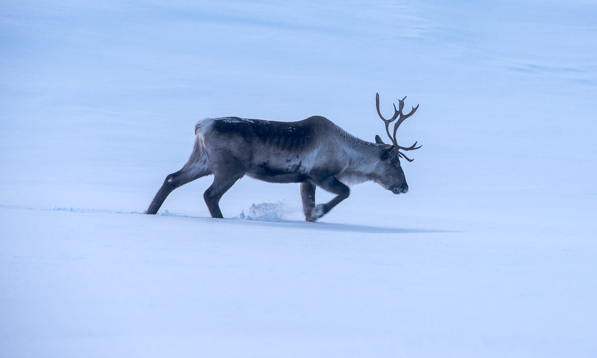
Kronprins Haakon is a Norwegian icebreaking polar research vessel. It was build 2018, can cut through one metre of solid ice, has 15 different laboratories on board and place for 35 scientists or other staff in addition to the crew.

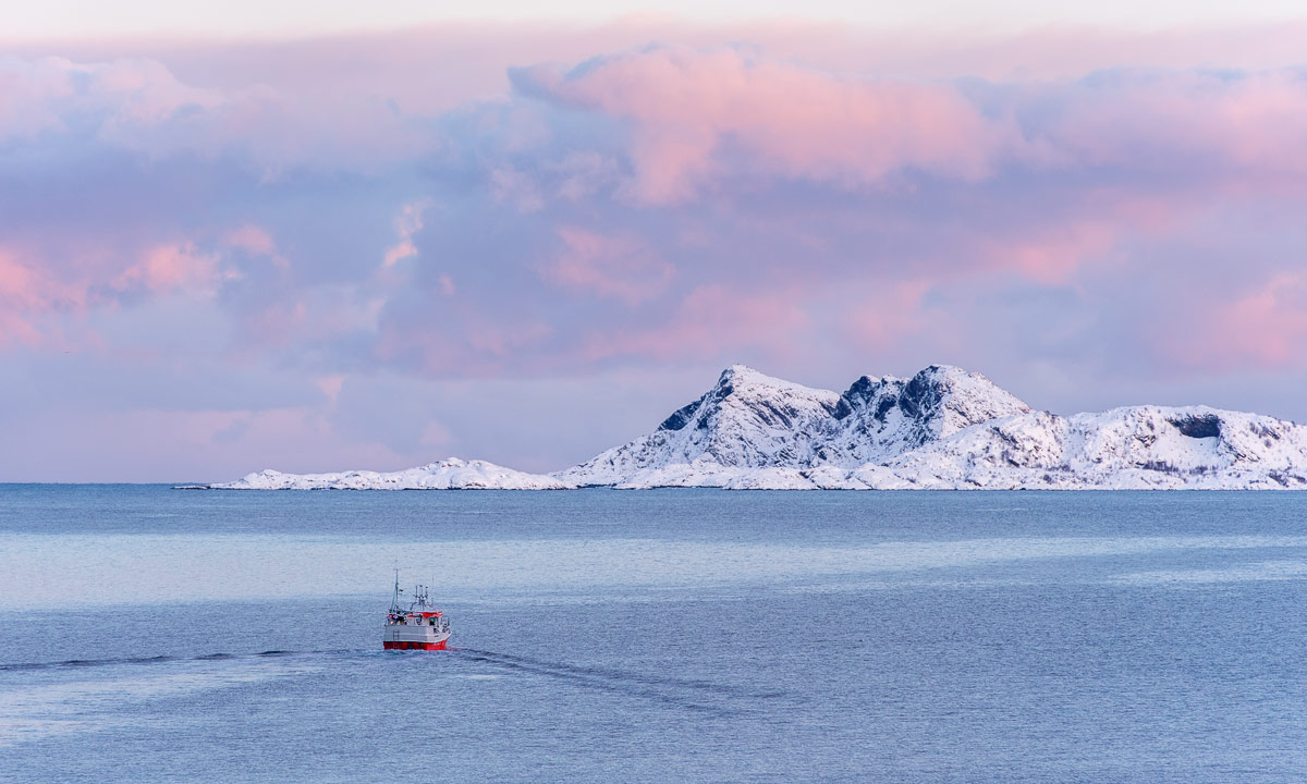
Four days ago Kronprins Haakon had arrived in Tromsø. It was travelling 26 days since it left Cape Town, the only stopover on its return trip from Antarctica.

This morning I went on board of Kronsprins Haakon. Not as a visitor to look around but with a suitcase, an enormous bag full of warm clothes, a heavy camera backpack and my Canada Goose down parka. I will stay on board for three weeks to participate the winter cruise “Arven etter Nansen JC3” that will lead us to the Barents Sea east of Svalbard and a bit beyond.

What happened?

Some of you may know that I’ve been working as a data engineer at the Norwegian Polar Institute in Tromsø since autumn 2020. In this position I’m not only a software developer but a data manager of polar research data.

Three and a half weeks ago my colleague M. told me she would join the winter cruise and mentioned that there might still be an available place.

Of course I was very eager to participate. Beside of my private passion for the Arctic I wanted to get a deeper and hands-on understanding of the research data. Where does it come from? How is it measured? And how is it transferred to the digital world? And nothing would teach me better than joining this very winter cruise, where conditions could be quite rough.

I mentioned it to M., another colleague and he introduced me to the expedition leader. There I was told that there was indeed a vacancy on board and that I was welcome to join if my boss would agree.

Since then it had been crazy times with some organisation, a lot of worries and little sleep.

  • 1 Feb: My boss had to check the budget for my participation.
  • 4 Feb: A seafarer’s doctor examined me and gave me my helseerklæring – a medical certificate that proves me “seaworthy”.
  • 16 Feb: I had to take a PCR test and wait for the result for two days. Then I had to take another PCR test, but that’s a whole story in itself.
  • 18 Feb: I had to do a survival suit training in the Tromsøsundet.
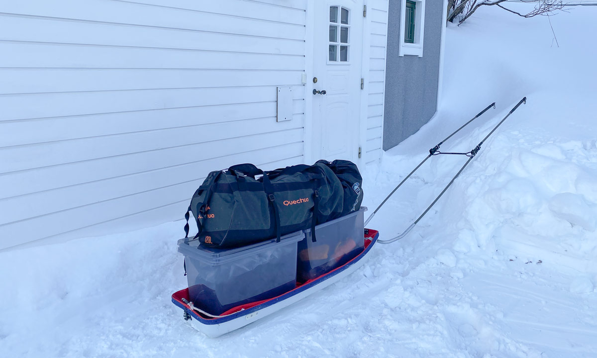
  • 18 Feb: I had to pack clothes and equipment I will need on the cruise. Everything beside of two pairs of boots, a helmet, a floating suit and a survival suit. These are provided by the Norwegian Polar Institute.
  • 19 Feb (today): I took a taxi to the port of Tromsø. I was driven directly to Kai 25, took some photos and then went on board.
  • Still today: passport control through the police, a security briefing, lunch and dinner, carrying boxes to the labs, entering the rescue boat and some more …

The next weeks

When Kronprins Haakon will leave Tromsø tomorrow morning we will sail north. First destination is a point referred as P1. It is approx. 500 km east of Svalbard’s southern tip. From there we will continue heading north to the other stations, if weather and sea ice conditions allow it.

The northernmost position is planned to be approx. 82° N, somewhere in the Arctic Ocean. That’s more than 10 degrees of altitude further north than I’ve ever been and less than 900 km to the North Pole.

I’m so excited, that’s really way up north!

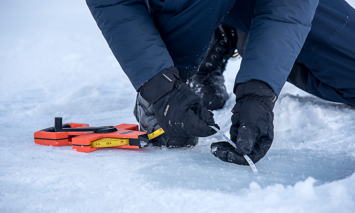
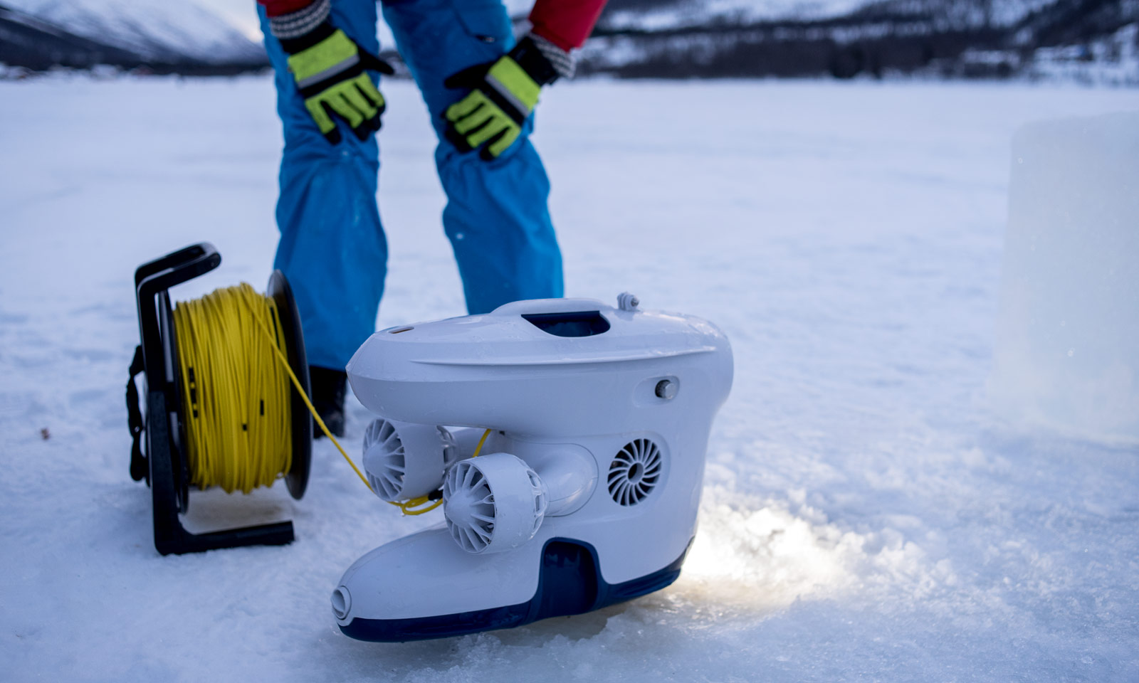
We will work both on the sea ice and on the ship using various measurement and sampling methods. Some of them I learned a bit last week but most of them I do not know yet. I’m a newbie. I’m here to learn. And hopefully I’ll learn a lot on this cruise.

After three weeks of tokt (Norwegian for “cruise”) we are supposed to arrive in Longyearbyen on 11 Mars. There I’ll take a flight back to Tromsø the same day.

I will not blog on this cruise because there will be a lot of work and hardly any reliable internet connection. But I’ll definitely take photos, both for the Norwegian Polar Institute and in private for this blog.

So, my dear readers, cross your fingers that I do not get seasick, we can reach our planned destinations and most of all that no one has Covid on board.

You can check the live position of the Kronprins Haakon on the map below. And you are welcome to leave a comment. See you again in mid-March when I’ll answer your comments and start posting articles.

23. Feb, 13:03: Just a short note: This map does not seem to work in polar regions. At time we have internet. Outside temperature -17.4 °C. Position round about 76°29′ N 31°11′ E.