Not reaching the top of the Nordtinden

Today I hiked the last daylight tour this season. Next Saturday sunrise is 11:25 and sunset is 11:38. The following day a seven week period of polar night will begin.

I wanted to hike onto the top of the Nordtinden (640 m), which I assumed to have a lot of snow after last Sunday’s experience. But it turned out different than planned.

Let’s start with a funny selfie:

What’s that? Winter jacket and no snow? Aren’t you overdressed, Olaf? Well, first I was glad about the fur-rimmed hood, because it was quite stormy already in the lowlands and then I wanted to gain 600 metres in altitude. It would be colder and windier on the top of the mountain.

Part 1 – hiking the icy gravel road

At 9 o’clock – round one hour before sunrise – I parked my car in Skulsfjord on the island Kvaløya. There was enough light to start the tour. First I followed a gravel road for 2.4 km. Easy peasy when not the whole road had been covered with ice. I had snow shoes with me for later use, but no spikes for the shoes. Mistake.

Part 2 – following the trail up

After 2.4 km I turned left to follow the hiking trail up to the mountain Nordtinden. Well, mostly I avoided following it because it was very icy and slippery. I considered cancelling the tour but often I could walk on the bouncy patches of heather beside the trail and so continue the tour.

Part 3 – gaining height

A steep passage made me doubt again. Shall I return? Continue? Well, let’s go a tiny bit further, just ten other metres up. I was lucky. Now the terrain was less steep. First only a bit of snow covered the stones and the heather but soon more and more snow covered the ground.

Part 4 – coming to a dead end

I knew that I lost the regular way. The way itself was not visible anymore, but I could see on my interactive map that I was a bit lower than the trail. Maybe I could go up somewhere else.

It was stormy and gusty and the wind tried to blow me down several times. The snow was not fluffy but wind pressed and hard and therefore slippery. When I had to traverse a slope I mounted my snowshoes. It took a while because I had some issues with the bindings. Now it dared to traverse the snow field, but since I didn’t take my walking sticks with me (mistake) it was a bit hard to walk up in the wind and gain balance.

And then I came to a dead end. A quite beautiful dead end, but still a dead end. I had to return.

Part 5 – returning, retrying and finally returning

So I walked back until I finally met the trail again, at least according my iPhone map. The way itself was hidden under the snow. Beside of that Norwegian hiking trails can be marked quite poorly, you have to navigate by yourself.

OK, I can navigate. I even had paper map and compass with me. But where the trail supposed to be there were only snow and rocks. And it was quite steep. And the snowshoes were a bit bitchy. And sun would set at 13 o’clock. Therefore I made the decision to not to try to reach the summit but abandon the tour and return. And so I did.

First I walked on snow but then I had to put off my snowshoes. In the lower part I ignored the icy trail and walked down on the heather. Much easier! Three and a half hours later I arrived at my parked car.

Résumé

It was a pity that I didn’t reach the top, but it was a fine though rough tour anyhow. From next week I have to find alternatives that are doable in twilight and darkness using a head torch.

For the records: 9.6 km, ca. 600 metres in altitude.

A wintry weekend in Saxnäs

If the mountain won’t come to Muhammad, Muhammad must go to the mountain.

While the coastal weather has still much too warm (last night it rained again onto the icy roads) you can still seek winter in the Swedish mountains. Annika and I used the long weekend to visit Saxnäs (and my piano tuner who owns a house there). Some days ago it had rained even there but fortunately it snowed afterwards and everything was white when we arrived there Friday evening.

Seven impressions of Saxnäs

1 – wind and snow

The night and the first day in Saadteskenjuana/Saxnäs was very windy with squalls round 20 m/s. That’s why we chose the car to look around, not the skies. The bay Faepmienloekte/Fatmomakkeviken, part of the large lake Gåaltoe/Kultsjön was partly open. Maybe because of the current of the stream Jeanoe/Ransarån, maybe because of the stormy wind and the warm weather. In the back the wind blew the new snow over the ice and highly into the air. It was not cold, but windproof clothes were necessary to feel comfortable.

A comment on the naming of the locations: The first part is the Sámi name, the second the Swedish name. The headlines and repetitions have only the Swedish names to keep it short.

2 – Fatmomakke

Faepmie/Fatmomakke is an old Sámi meeting point. In 1781 the Swedes erected a first chapel. Both Sámi and Swedish people lived here. Since 2014 it is a “kulturreservat” – an area to protect the culture of that place. I loved the old wooden houses by the lake Gåaltoe/Kultsjön.

3 – lake and mountains

When we drove back we still could see snow blowing over the lake. Above the whirling snow dust the risen sun had started to illuminate the mountains of the Marsfjäll.

Step by step we drove back to Saxnäs and I used every parking place to take pictures.

4 – polar stratospheric clouds

A rare phenomenon had been observed the last days: polar stratospheric clouds. I already could see some the days before on my way from Skelleftehamn to Umeå. Now in Saxnäs they were spread over half the afternoon sky. If they are near the sun the light is diffracted and the clouds are very colourful. I have seen such clouds before but never as intense and colourful as that day.

5 – skiing through the dark

In 2005 I bought my first fjällskidor – backcountry skis with steel edges. I had used them on many tours – from short half-day trips to multi-day winter tours with pulka and tent. They had become quite worn and battered, therefore I bought a new pair some weeks ago, including new boots. Now it was time to test them.

The test went very well, but the ski track around the lake we didn’t find. So we went cross-country and returned after a while. The way back was much faster because we could follow our own tracks and didn’t have to navigate.

6 – cross country skiing

The next day was grey but quite calm. We took the car to the Bagarstugan, starting point of the ski tracks in Saxnäs. The ski tracks weren’t prepared yet but some minutes later we met a man that was about to start the preparation. The classical tracks are prepared by snow mobile, the broader skating tracks by snowcat. So finally we were lucky to have our cross country ski premiere on a freshly cut track. Great!

7 – Saxnäs by night

Annika invited me to dinner and we decided to walk the 2 km from my piano tuner’s house to the hotel. Good to have some motion before and after dinner. We passed the closed village shop and soon approached the hotel. Urgently recommended: reflex vests to be seen by the cars.

Beside of the employees we were completely alone in the large hotel restaurant. It’s still pre-season.

Now I’m back in Skelleftehamn. The road is icy and wet from last night’s rain. The average of the max temperature forecast for the next 9 days: +1.3 °C. Come on, winter, where are you!?

Translation:

EnglishGerman
polar stratospheric cloudPerlmuttwolke

March snow in Skelleftehamn

For yesterday, the day we drove back from Murmansk, the weather service issued a snow warning. I had parked my car in Bjässviken at the house of B., another participant and it was covered with 10-15 cm of snow. B. fetched a broom helped me to free my car.

When I came home, even the minor streets had been cleared of snow. On the one hand this is great for driving, on the other hand it meant I couldn’t park my car on my property. I first had to remove the plogkanten, the wall of snow that the snow plough had pushed aside in front of all the garage driveways. I was tired after almost 15 hours of travelling, but clearing the plogkanten didn’t take much time and after that I could park my car beside the house.

When I woke up, it had stopped snowing, but another 10 cm of snow had fallen over night. Again the street had been cleared already. So another plogkanten blocked the way for the car. With temperatures slightly above zero this snow was wet and heavy and it was much more exhausting to move away this snow, especially because my “private snow dump” in my front yard is getting larger and larger.

Taking a break I stomped through the deep wet snow taking some pictures. I measured 77 cm of snow in my backyard – that’s something for the midst of March.

Perhaps I should buy a new car. Yesterday I saw a nice one at the petrol station in Алакуртти/Alakurtti. The advantage: I probably never have to clear snow again. The disadvantage: beside of being slow the topic of petrol consumption should be avoided …

By the way: While I wrote this article it had started snowing again.

Snowy night, snowy day

When I returned from Avan two days ago the Swedish weather institute SMHI had issued a snow warning: 20-30 cm snowfall and at the coast fresh winds from northeast. Yesterday the wind increased and in the afternoon it started to snow. Soon the snowfall increased, too and the wind made the snow whirl round the houses and through the streets. More and more snow came falling down and soon the street was snowed over completely.

“Beep! Beeep! Krrrr. BEEEP! KRRRRR!” – these sounds woke me up this morning at 5 o’clock. The sound of snowploughs and shovel loaders clearing the roads. They beep when they go backwards and the shovels make loud scraping noises.

While the shovel loaders take the snow and move it to other places the snowploughs just push the deep snow aside. Both are important but the latter create work for the locals. They create a so-called plogkant – compact walls of snow – along the street and so right in front of your driveway.

This plogkanten was 60 cm high and the loose snow behind was of almost the same height. Before I could use the car I had to shovel snow. A lot of snow, at least 2½ m³. Fortunately the temperatures where round -10 °C and the snow was loose and fluffy. A good workout anyway. Finally I could get camera and tripod and took the car to two places by the sea.

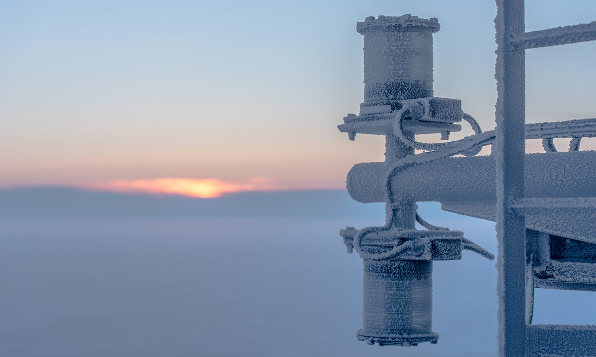
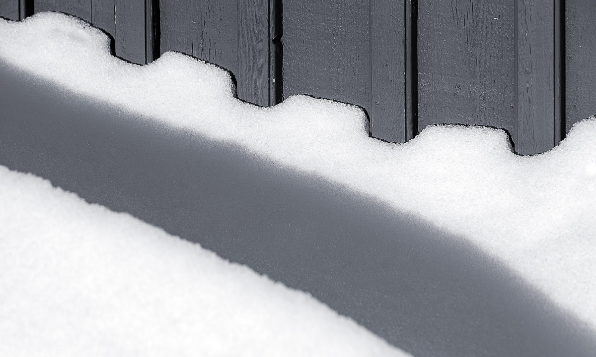
The garage at the pilot station was surrounded by meter-high snowdrifts. The snowdrifts in the lee of the house were even higher. The gaps in the fence created a nice stripe pattern on the snowdrift outside. It was still quite dark and there was not much to see otherwise.

At the “beach” of Storgrundet the stormy gusts of wind blew the snow horizontally from left and right and in the dawn the scenery looked very harsh.

Great weather for a ski tour on the sea ice, isn’t it?

Two and a half hours later: Chris – a friend of mine from Kirkenes who arrived yesterday – and I had just come to the very same place to start a ski tour. We mounted the skies, put our hoods on and slipped into the gloves. It still was snowing and quite windy.

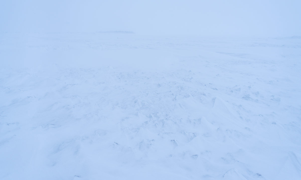
And when it’s windy at the mainland you can bet that it’s much more windy on the sea ice which is completely exposed to the elements. And so it was. The island Storgrundet was in the back and we could see the pale schemes of some other islands in the northwest. The northeast however looked like the Arctic Zone.

Chris was following my ski tracks. She looked like an arctic explorer with the white void in the background.

Here’s one of of the rare photos of me, that is no selfie. If you look closer you see that my ski tracks go zig-zag. That’s because even on the sea ice of the Baltic Sea there were many snowdrifts with sharp edges and I could hardly see whether it went up or down. Skiing was not exhausting but we were slow due to the wind and the bad sight. (… and taking pictures.)

We skied to a headland which had been in sight for a while.

As soon as we reached the lee of the headland it was almost windless. What a huge difference to the exposed parts of the sea where weather was quite rough. In the shelter of the headland we took a break. (We forget the tea in my kitchen but at least we had a bit of chocolate.) On the headland were summer cottages, now snowbound in meter-high snowdrifts.

The way back was easier. The gusty wind had started calm down a bit and the snowfall lessened. The view to the west however was still extremely arctic.

We were however no arctic explorers but had the luxury of a parked car and a heated house just some minutes away. The ski tour was short in distance but rich in experience and that’s what counts!

Takk for turen, Chris!

It continued snowing until dark. The fence in my backyard had been buried in snow almost completely. The fence is 85 cm high.

Later in the afternoon I continued clearing snow. Not with a front loader but with a wide snow shovel. Chris has parked her car on the street and both the snowfall and the snowplough had buried it up to the top of the wheels. I pushed all snow into the front yard where the snow pile got higher and higher.

I’m a quite curious person when it comes to snow depths. I made a step on the top of the snow pile and as I guessed the snow was quite loose:

If the forecast is right we get calm, sunny and colder winter weather tomorrow. We consider to start the very same ski tour again just to see the difference.


The ice road in Avan

Today I had a meeting in Norrbotten, Sweden’s northernmost län (county). It was the annual general meeting of Barents Press International, a joint network of journalists in the Barents Region. I joined this organisation a few weeks ago and took the meeting as an opportunity to meet members of Barents Press in real live.

The projects presented at the meeting were really impressing. In addition to that the people were both very friendly and extremely interesting.

The meeting was in Avan near Luleå, 150 km from here or as the Swedes say: 15 miles. The name Avan rang a bell, but it took a look on the map to remember that it’s the place where Annika and I had used the ferry to cross the river Luleälven in May 2015. And later that day we had been forced to wait before a bridge, where people tried to get out a ship with a crane. (It didn’t work.) After a long time of waiting we had been able to continue the tour.

But back to today. It’s 2 February, -18 °C and the Luleälven had been frozen for many weeks.

I had left the E4 and drove the road to Avan. It was picture-perfect weather. Everything was covered with soft snow. It was snowing gently and since it was quite early, the snow looked still a bit blueish.

Some hours later – we had finished the meeting and went upstairs to have fika. This Swedish coffee break took at least twice the time of the official meeting, but fika is anything between 15-30 minutes (most common) and open end …

While we were holding fika and it was still snowing the sun came out. The sunlight made the scenery look even more beautiful. What a gorgeous view the house owners have!

Half past twelve I thanked the hosts and left Avan. I had got an idea: I remembered that there was an ice road crossing the river in wintertime. I was not sure if it was open but it was not far away. I drove there and right, the ice road over the Luleälven was open.

It had stopped snowing and the sun was shining. I parked the car and took some pictures (and was annoyed with myself that I only took the small camera with me).

I saw other cars using the ice road, otherwise I wouldn’t have dared to cross the river, which still is a river with water under the ice. Flowing water. Ok, let’s go …

And so I have got my ice road premiere today. Check ✔︎. I took some photos on the other side and decided to drive back again because I prefer the southern road which I came from.

It was still sunny but clouds had started gathering in the south. While I drove back south it got more and more cloudy. When I made a stopover at my favourite Thai restaurant in Skellefteå it was quite windy and my mobile phone displayed a message:

Warning class 1 snowfall Västerbottens … Snowfall which from Sunday morning to night to Monday can give 20-30 cm. In coastal areas in combination with fresh northeast wind. Snowfall contin…

Later there were the first snow showers. Let’s see, what will happen tomorrow.

Snowshoe tour on the Vyöhtjage

The situation is like three years ago: it’s the days after Christmas and there is not much snow in Skelleftehamn. As in 2015 Annika and I decide to make a tour to Arvidsjaur.

Arvidsjaur lies northwest of Skelleftehamn, two hours drive away in the inland. It is located in Norrbotten, Sweden most northern county, is part of the historical province Lappland and part of Sapmí, the region of the Sámi people. Arvidsjaur is well known by German Sweden fans since there are direct flights in wintertime from several German cities.

Arvidsjaur has a nice mountain called Vyöhtjage (Sámi) or Vittjåkk (Swedish). The Vyöhtjage is too steep for us to use skis so we used snow shoes to go up to the mountain top (650 m).

Here some photos of yesterdays tour:

It’s funny that we did almost the same tour (with another route) to the Vyöhtjage as exactly three years ago with the same weather (sunny and not too cold) and snow conditions (half a meter of snow). This nice place however is worth to be visited several times, especially because it is quite near to Skelleftehamn.

We had an overnight stay in Arvidsjaur. Today we will drive back but take a stopover in the village Kusfors to visit friends.

A mountain tour in Arvidsjaur

Yesterday I used my new car to drive to Vittjåkk, a small skiing area near Arvidsjaur, two hours away from home. Annika and I were there in wintertime and made a showshoe tour up the hills. I lived in Munich for six years and do not call these hills real mountains, but at least they reach above the treeline.

I parked again at the same parking lot and ascended the first hill that seems to be nameless. The sky was free of clouds, it was quite warm and I was completely alone.

Soon I was on top of the first hill. I wasn’t alone anymore. Some horseflies tried to make friends with me or at least with my blood. I descended the first hill and went up the Vittjåkk.

From the top I had a wide view over large forests, lakes and a higher mountain range.

Beside of taking pictures I didn’t rest because the horseflies really loved me. So I continued downhill again and was a bit flabbergasted that the whole hike took hardly more than 90 minutes. The hut village was completely abandoned, only a snowmobile showed that this place is only used in wintertime. And other signs showed that too …

Four typical observations in Northern Sweden’s inland in summer, when you go by car

One: construction sites. Almost all major roads are under constant repair each summer. It takes a lot of time to travel. Sometimes you have to wait for a traffic light becoming green or a follow-me car. Sometimes you follow an expencive camper whose driver doesn’t dare to drive more than 20 km/h on the gravelly sections. And this may go on for miles. Swedish miles! (A Swedish mile is 10 km.)

Two: lupins. Many roadsides are overgrown with lupins. They are beautiful, but they are invasive and threaten biodiversity. The Swedish Transport Agency has started to fight theses flowers.

Three: reindeers. Most reindeers are in the mountains but there are always reindeers left in the inland. Keep attention when driving! When you see one reindeer you can be quite sure that others are around, too.

Four: bilingual town signs. On many place in Northern Sweden you are in two countries at the same time. Sweden, the official nation and Sápmi, the region traditionally inhabited by the Sami people. Therefore many places have (at least) two names, a Swedish and a Sami one.

I drove a lot yesterday: 535 km in total. But as a result I know the new Subaru Outback much better and got used both to the automatic gearbox as the electronic systems. I’m very satisfied with the car that is much more comfortable than the old one. The only drawback, it might be the white colour: The horseflies just love the car. When I return to the car it is mostly surrounded by some dozens of this pests and they will even try to follow when I set off. (They manage round 25 km/h.)


Opening the bicycle saison in Skellefteå

Today it was the first day where I used the bicycle from home to Skellefteå. That’s about 19 km per direction and I want to use the bicycle at least twice a week on my way to the job. Let’s see if I can do it. At least a first beginning is made.

Skelleftehamn – Skellefteå:

Skellefteå – Skelleftehamn:

Tour rules: Use a complete different way back to Skelleftehamn.

Photo rules: Take only photos from the bike, cycling or standing. Do not crop any photo. Use only basic corrections.

The island Fårö

This article is part of the series “2018-05: Gotland”.

It’s Thursday, our 4th full day on Gotland. Today we want to hire a car, meet Ingrid again and explore Fårö, an island northeast from Gotland.

We return our e-bikes, that we used the last two days and walk to Mickes biluthyrning, where we rent a VW Passat from 1995. Annika drives. We fill up the car and drive to Lärbro, where we meet Ingrid. She has been living on Gotland for a year and will guide us around.

In Fårösund we drive on the free ferry; the ferry crossing takes only 8 minutes. Then we are on Fårö.

First stop: Fårö kyrka. Beside this church used to be a tourist information, but it doesn’t exist anymore. It’s not a big problem, since Ingrid knows all these places she wants to show us.

The next stop however is a request of Annika and me: a real bakery! With a few exceptions, there are no bakeries in Northern Sweden and we enjoy visiting this one. We buy bread and cake and take a break to eat the latter.

We drive through the landscapes of Fårö, which are as varied as Gotland’s landscapes. Sometimes you think, you are in Spain or Greece, sometimes you believe being in Northern Germany and (only) sometimes in Sweden. Now I understand the Swedish people better, who say that Gotland is not Sweden.

Next stop Fårö Fyr, the lighthouse of Fårö, located at the easternmost point of Fårö. There’s a beautiful rock coast, but we do not stay very long, there’s a lot to see.

Next stop Skärsändan, a beautiful sandy beach that is several kilometres long. Annika and I take a bath (the water is quite shallow) and then Ingrid, Annika and I walk barefooted along the beach.

After a longer promenade we continue our Fårö exploration trip. On the way to Langhammars Raukar we make a stopover. Here we find many things typical for Gotland and Fårö: grey sheep, windmills, thatched houses, braided fences and dry stone walls.

Next stop is Langhammars Raukar, one of the famous spots with rauks – steep limestone formations formed by the waves of the sea. On of them reminds me on the stone statues of the Easter Island.

We continue to another fascinating spot, three kilometres away: Helgumannen, an old abandoned fishing village. This group of tiny wooden houses located on a rocky beach that seems to be endless looks really remote and I ask myself what kind of live the inhabitants had.

The last stop on Fårö for today: Gamle Hamn, another spot well-known for raukar. The last photo shows the “coffee pot”. Personally it reminds me more of Buckbeak, the hippogriff in Harry Potter.

I has become late, we are hungry and a bit tired. Ingrid drives the way back to the ferry and soon we are on Gotland again. Here we take the first restaurant and get something to eat, before we drive back to Lärbro and say goodbye to Ingrid.

Tusen takk, Ingrid for a wonderful day!

When Annika and I arrive in Visby it’s so late that the sun sets and the ice cream shop is already closed.