Tverrfjellet on a sunny Sunday afternoon.


This summer vacation with Annika had a clear photographical focus: showing the bathing areas we or I hopped in. It was ponds, lakes and rivers where we enjoyed bathing and swimming on our one week trip through northern Sweden and Finland.
The places and bodies of waters were:
Bygdeträsk (Göksjön) — Mårdseleforsen (Vindelälven) — Harads (Luleälven) — Tolkibadet — Harriniva (Etuväylä/Torne älv) — Kittilä (Ounasjoki) — Aarniluosto (Aarnilampi) — 2× Ylitornio (Etuväylä/Torne älv) — Hovlösjön.


And the motto? Allt kommer att bli bra. Everything will be fine.

After to weeks of home office home in Sweden Annika and I have a week of vacation. Yesterday we went to a concert of the Umeå based balkan folk band Mullin Mallin on the island Norrbyskär. On the ferry there it rained.


But then the weather became better.

While the soundcheck it was drizzling a bit but then the sun came out and we could listen to Mullin Mallin under a blue sky.
After the concert Annika and I had almost two hours until the 22:30 ferry that only runs after evening events. Time to sit by the sea and watch the sun set. While the sun was disappearing behind a cloud the ship was approaching. We went on board and were brought back to Norrbyn on the mainland, where Annika had parked her car.


After a 40 minute drive we were home. That day was a great way to start our vacation. Norrbyskär is always worth a visit, even when it rains and you have to eat the ice cream inside.
That’s me, nine days ago, near a parking place by the lake Finnvikvatnet on the island Kvaløya.

I just got a drone from the Norwegian Polar Institute, a DJI Mavic Pro 2. Since it is forbidden to fly a drone in Tromsø (too near to the airport) I chose a place on Kvaløya to check out the drone and practise a bit.
What you may expect from drone flying is photos like this:

What I actually did that day was taking a bunch of photos like these:


Back at home let the computer do some heavy work. That’s the result:

What I wanted to achieve is creating a so-called orthophoto. That is a stitched image that also contains geographical information. You need quite a lot of photos to get good results. In the map above it is only 9 photos and 11 photos in two distinct groups.
I used two softwares: First OpenDroneMap to create the orthophoto and then QGIS, an open source Geographic Information System, to present the orthophoto in a geographical context.
This afternoon I took a trip to Kvaløya again, this time to the way to Sommarøya and stopped by the lake Kattfjordvatnet. Here I pulled up the drone to an altitude of 80 metres and tried to navigate a rectangular zig-zag pattern with a lot of overlapping between the images. Beside of the fact, that the images are underexposed (and I was too lazy to correct them) I’m quite content with the result. The first image is an oblique shot, the second image is an orthophoto calculated from about 80 images and then placed into QGIS.


Plan for the next two weeks: getting more practise!
What is the difference between these two photos?


Half an hour and round about 60 metres in altitude. The first photo shows – quite visible – a bunch of tussilago flowers, the second one – pretty hidden – a tombstone on the Elverhøy graveyard.
I cannot answer why the differences are so immense on the island Tromsøya. I only can observe that while it looks like spring is coming to the coastal parts the ridge of the island is still wintry. There are old ski tracks and the lake Prestvannet (96 m) is still covered with ice and snow.


I walk round the lake. Some parts of the way are free of snow, most aren’t.


I take a photo from a bench. A woman passes by and asks me: “Tar du vårbilder?” – do you take spring pictures? Well, kind of … .


I have an appointment at 18:00 so I leave the “mountains” of Tromsø and descend into town. While the small slide near Prestvannet is still snowed in the playground lower in town is completely free of snow. And I don’t think, they have underfloor heating. (Not impossible in Tromsø.)


Later, at 22:45 I walk to the bus that brings be home. It’s still quite light outside. No wonder, it’s only 20 days left to the period of the midnight sun.

Have a look at these two images. They have something in common.


Both are related to my participation in the Arctic Ocean cruise in June. After the Nansen legacy cruise last year this will be my second scientific cruise to the Arctic with the Norwegian Polar Institute. And this time I’ve got extra tasks.
A scientist asked if I could fly a drone to map the ice stations. I didn’t have any experience in drone flying so I bought a private one to practise some weeks ago. In addition to that I made the Norwegian online course in drones (class A1 and A3) and the exam. Now I’m registered as a drone pilot in Norway, both in private and for the Norwegian Polar Institute. That was the easy part.
The interesting part starts when I shall take photos with latitude and longitude information from a drifting ice floe. But I’m not there yet (and quite happy that I have another month of preparation).
The drone photo above was taken in Norway. In Sweden it is a lot of paperwork to get permission for the publication of photos, especially when they show the sea as well. In Norway this is not the case, as long as you know the legal rules and restrictions.
To help both the cruise leader and the crew with planning it will be my job to provide them with current information. That’s ice charts coming from a SAR satellite and weather forecasts for e.g. wind, temperature and pressure. The data will be presented using the Open Source Geographic Information System QGIS. The screenshot above is just from a small learning session where I loaded in quite unrelated data as a topographical map of Svalbard, an ice chart from two days ago and current wind information.
The interesting thing will begin when we head north, leaving Svalbard behind. Then we do not have internet access anymore except sending and receiving emails through the slow and expensive Iridium network. So I cannot use all the cool QGIS plugins to gather data directly but I’ll have to send data requests per email and then receive the data later. This will be both interesting and challenging. I’m somewhere in the middle of being quite excited and pretty nervous.
Anyhow I wanted to have jobs and tasks and I’m glad I get the opportunity in a more active role than last year, were I was more like an observer. I guess, I’ll learn a lot.
Arctic Ocean, soon I’ll come!
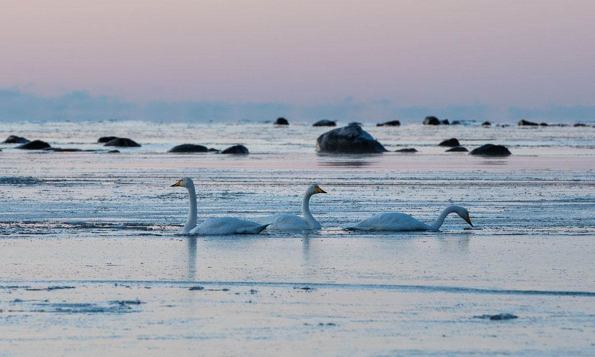
Last Tuesday it got sunny and I paddled kayak. On Wednesday it got cold and the small sound between island Lillskär and mainland was covered with ice.

Although it’s mid-December and despite temperatures between -10 °C and -14 °C there were still whooper swans around. Don’t they migrate south? In the morning they managed to paddle through last night’s fresh and thin sea ice. In the afternoon the swans had left. Perhaps they finally decided to fly south.
On Thursday it snowed. In the afternoon 10 cm of fresh snow had fallen and everything was white and bright, even in the night.


On Friday Annika and I had a day off and visited friends in for a long weekend. They live in Kusfors in the inland, round 180 km north. On the way there and there we found more winter. It was not very cold but it snowed quite a lot. I took some images from the car while Annika was driving.


Yesterday on Sunday we came back to our house in Obbola round 20:00. Our property was covered with 45 of fresh snow. Since it had been sub-zero all the days the snow was pretty fluffy. We had to do quite a bit of snow shovelling – but after taking a photo.

Today it’s Monday and a new working week has begun. I had a lot of meetings today and therefore no time to paddle kayak. Oh yes, the kayaks … where are they? I know they lie beside the wooden terrace. Here they are, well hidden under a thick blanket of snow, right beside the window of the winter garden.

But there are other things to do as well. For example opening the afterwork ski season in Olles Spår near Umeå together with Annika. The snow is still soft and the cross-country skiing trail still slow but the first time of skiing is always special and we are happy and grateful that we live in a place where winter is around us.

Now it’s half past nine in the evening and I’m blogging. Snow is falling and the thermometer shows -9.5 °C, the same temperature as the last hours.
And you? What kind of winter do you like? Or do you prefer other seasons?
This article is part of the series “2022-08: Jämtland and Trøndelag”.
I’m sitting in the train to Umeå. We have a longer stop in Kiruna where the train changes direction. The other trains standing here are cargo trains that transport iron ore from the mines around. Temperature is -10 °C or lower and there are some centimetres of snow covering the ground. Winter finally has arrived in the Swedish fjäll.

I’m so glad to arrive home in Obbola tonight. I haven’t been there since July. Now I’ll stay until Christmas working from home for the Norwegian Polar Institute.
I’ve been however in Sweden in August, too. Not home but for a hiking tour with my sister and family together with my wife Annika.
This reminds me that I almost forgot to publish the last blog article about our hiking trip in the Jämtland. It will take more than seven more hours until I arrive in Umeå, so there’s plenty of time to start blogging now, as long as the mobile net allows. Earlier I’ve written about the cabins, some day trips, the trail and way marks. Today I want to show some photos of the landscape. Let’s go back three months in time. It is late summer in Sweden.
What I love about the Swedish mountains – the fjäll – is its variety. Not only in weather but also in landscapes. In the lowlands there are forests – mostly birch forests – but all Swedish cabins we visited lie above the tree line and here you have a wide view of the mountains, small and large lakes, rivers and streams, bogs and stone deserts. Let’s have a look.
15 August, our first day. The landscape is rising and we have left the forest behind. The trail between Storlien and Blåhammaren leads over many swamps and bogs and is wet and muddy.

16 August. We leave Jämtland and cross the border to Norway. The cabin Storerikvollen lies quite low and we descend through forests of crooked birches.

18 August. Still in Norway we take a resting day at Nedalshytta. I talk a walk along the lake Nesjøen. The water level is extremely low and so I can cross some mud fields that normally are under water. This landscape looks a bit hostile and is not typical for this region.

19 August. Again the terrain is wet and has many small lakes and water puddles. The mountains are hidden behind low hanging clouds.

We start hiking up the Ekorrpasset. Looking back we witness one of the most unphotographable landscapes I know. In reality it is an impressive view of a hilly terrain with uncountable lakes, ponds, streams and puddles. The photos however always look pale, blurred and boring.

Let’s not look back but ahead. The peak of the pass is more than 1300 metres high. That may not be much in the alps, but in these latitudes only few plant can survive these altitudes and so we walk through a desert of stones and rocks. Hidden in between some moss and the flower Ranunculus glacialis.

And let’s look aside. We pass the mighty Sylarna massif (1574 m) with its glaciers and rugged rocks. Impressive.

The Sylarna cabins lie lower. Grass and heather cover the ground presenting the landscape much more mellow, especially in the soft colours of dusk.

20 August. We leave Sylarna and continue to Gåsen. For that we have to hike through the valley of the river Handölan. Here we meet birch forests again. And some quite impressive rapids.


22 August. After a resting day in Gåsen we continue to Helags. The landscape is wide and broad. And where it is not too wet there are surely some reindeer around.

24 August. We are on our way to Fältjägaren, the last cabin of our tour. The weather is sunny and we are accompanied by the mountain Predikstolen (the pulpit) which shows itself from some of its many beautiful sides.

In the evening we stand outside watching the sunset and the incoming night. Soon the lakes are the only part of the landscapes visible. The rest is almost black.

25 August. Our last hiking day. On the other side of the valley we can see the gaps in the forests covering the mountain slopes. These are the ski slopes of Ramundberget where we’ll take the bus to Östersund. Back to civilisation.

And back to the present. I’m still sitting in the train. Where am I? Ah – half an hour left to Gällivare. Now I’m longing for a cold and snowy winter. But then I want to change ski boots with rubber boots and go for a hike again.
This article is part of the series “2022-10: Autumn in Scotland”.
You cannot deny, that Scotland can be a pretty wet land. There are however different kinds of wetnesses.
This kind of wetness I love: bathing in the sea. Finally Annika and I managed to find a sandy beach that looked very promising for taking a bath. And it was perfect. No stones, no currents, no sharp-edged shells, no waves as high as a house. The water was warmer than expected and it hardly rained.


We continued our road trip through the region of Assynt and parked our car by the Stoer Lighthouse. From there we took a circular hike to the Old Man of Stoer, a 60 metre high sea stack. It rained and the trail was soaking wet and partially quite muddy. I managed to keep my rubber boots dry but Annika’s hiking boots were soaking wet after our hike. Her dancing experience helped her to change to dry shoes.


As the days before it was Annika that drove the rental cars. You don’t want to fall asleep while driving in Scotland. Beside the single file tracks with its many meeting points sometimes the roads are blocked by sheep. The road sign warning of a 25% steep hill however looked much more dramatic than the road was.


We have passed Ardvreck Castle several times the last days. Now it was time to stop and have a look.


The lake Loch Assynt was flooded and so was the path to the castle. I like hiking in rubber boots which is a bit overdressed sometimes. In Scotland however I think it’s perfect footwear. Here they helped me to wade to the castle to take some more photos, while Annika waited ashore.

I almost forgot to tell: At the beach of Clashnessie I observed sea monsters! Carefully I sneaked up to one of them and I managed to take a photo as a proof. There are sea monsters in Scotland!
10 cm high sea monsters.
10 cm high sea monsters buried in the sand.
10 cm high sea monsters buried in the sand looking suspiciously like seaweed.

This article is part of the series “2022-10: Autumn in Scotland”.
It’s 12 October, day 6 of Annika’s and my Scotland holiday this autumn. Today we want to hike round the Stac Pollaidh – or “Stac Polly” – a mountain in the Assynt region of the Northwest highlands. Its twin summit is quite prominent. We start our tour after lunch, where weather was supposed to get better. (And it was.)
Slowly we start hiking up following the excellent cobblestone path.

Technically our tour follows a circular path round the summits, but it climbs up almost on level of the east summit. The west summit is round 80 metres higher and needs a certain amount of scrambling and mountaineering experience that we lack.
It is still cloudy, but the sun starts to peek more and more through breaks in the clouds. Quite soon the views are impressive, from hazy tones of dark grey against the light to circular views that seem to cover the whole Assynt region. Harsh mountain tops – nunataks in the ice age – hilly landscapes – countless lakes, and to the west: the sea.

The ascent gets a bit steeper, the cobblestone path zigzags up the mountain. The passing clouds constantly change the landscape’s appearance. Again and again I have to look back for the views.

Finally we arrive at the junction to the east summit. It is not far to climb it and it rewards with a scenic 360° view, only interrupted by the higher west summit. Stunning! Me meet a local that shows and names all mountain massifs and tops around. Wind increases and we are pretty glad about our windproof clothes.


It’s hard to leave this beautiful place but finally we leave the summit and walk back to our circular route. The first part is near perfection, then it gets quite muddy and slippery. But the views are still awesome.

The more we loose elevation the more we approach our starting point. We can see the harsh rocks of the west summit and partially hidden behind the east summit that we just had visited. The sky is bluer than and Stac Pollaidh looks friendly. Other mountains in directing sun however look sombre and almost hostile.


We reach a last sheep gate and shortly after arrive at the parking place.

Two photos in portrait format – they never blend in with my other landscape format photos. The first is from the ascent, the second from the descent.


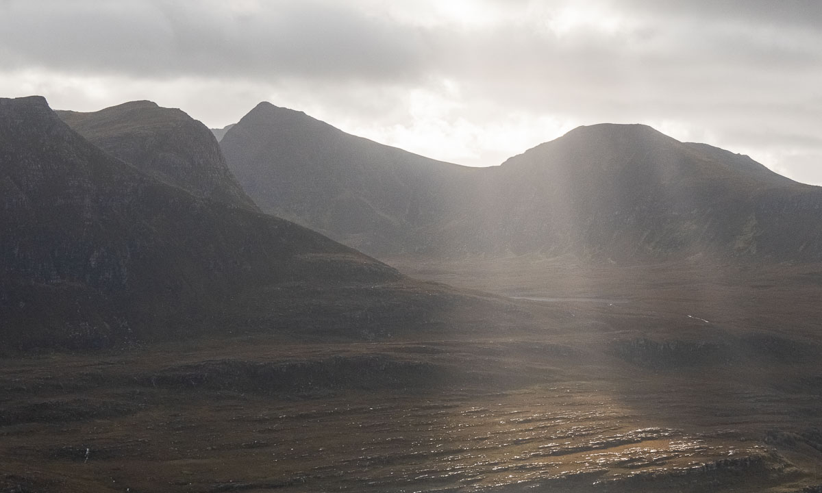
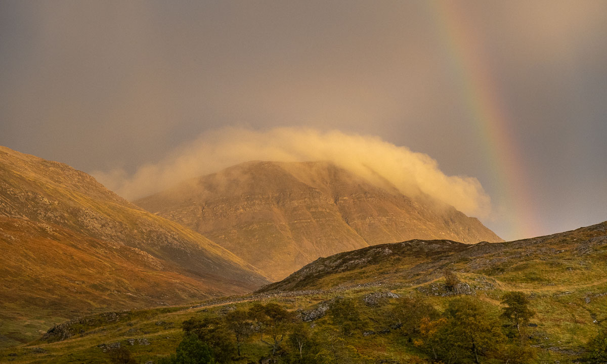
Shortly after we have arrived at the car it is starting to rain. Wow, that’s perfect timing! And beyond that it rewards us with one of the most durable double rainbows I ever saw. Intensely it is shining for more than 40 minutes while we are driving to our hostel in Inchnadamph. Even when it gets dark the sun still is illuminating a cloud blanketing a mountain.


Along with our day on Isle of Lewis’ west coast this day is definitely one of my personal highlights of our holiday. Thank you Annika for planning the tour and sharing the experience!