A kayak trip shorter than expected

About neoprene suits, the post-glacial rebound and changed lunch plans.

Today I wanted to paddle to Själagrundet, an island 1.6 km from mainland. The air may be warm but the water is still cold and that’s the element you should be prepared for in case of capsizing. Today I decided against the bulky drysuit and chose a thin neoprene suit for the first time.

The suit is very tight (especially if you each too much chocolate …) and hard to put on. After I managed to squeeze myself into the suit and to close the back zipper it felt quite comfortable. Until I started paddling. It was much harder to move the paddle than usual because of the tight neoprene sleeves. Every paddle stroke felt like training with a rubber band. I got used to it after a while, but neoprene will probably not become my favourite choice of kayak clothing.

I passed the island Storgrundet and headed northeast. The waves came exactly from the side which is the worst direction regarding stability. So I zigzagged a bit to avoid the waves rocking the kayak too much. Nevertheless the island came closer and closer and soon I got out of the kayak and dragged it ashore. The seagulls didn’t like my arrival. Screeching loudly they rose in the air, sailed in the wind and didn’t dare to land as long as I occupied their private property.

There are many islands whose name ends with -grundet. From Skelleftehamn for example you can paddle to Storgrundet, Norrskärsgrundet or Nygrundet. The Swedish word grund means (among others) shallow, so the translations of the islands mentioned above are: the Large-Shallow, the North-Skerry-Shallow, the New-Shallow.

Who is to blame? The post-glacial rebound! After the last glacial period the glaciers started to melt. Slowly the land, that had been compressed by the huge weight of the ice sheet started to expand. It is still expanding and rising – round 8–9 mm a year. Therefore some islands are quite new. Själagrundet for example is hardly older than 100 years. They got their names from the old times when they weren’t islands yet but shallow underwater-banks that the fishermen had to take care of.

Today Själagrundet still is mainly a large gravel bank. Only on the higher eastern side plants had started to grow. Mostly it’s flowers, but two small bushes and a small willow tree have settled there as well.

I walked around and had a look at the 260 meter long island until I got hungry and wanted to eat my lunch – salad and a chocolate bar. When I looked at the dark grey clouds that seemed to approach the island I changed my plans. Did I hear the rumble of thunder? When I would be hit by a thunderstorm on this flat island without any shelter I could get into serious trouble. I checked the speed of the clouds and decided that the best option was to paddle back to mainland, now and quickly.

I had a fast start and paddled quicker than usual until half of the distance lay behind me. It was quite exhausting –remember the neoprene suit? When I realised that there was no immediate danger of thunderstorm and lightning I slowed down. I took my dinner on the island Storgrundet. A save place with summer houses and hardly 100 metres from mainland. Then I paddled back to the small beach at the mainland, took off the neoprene suit and had a refreshing bath in the Baltic Sea in the sun.


White nights

Since the summer solstice on 21 June the nights are slowly getting longer again. Last night sunset was 23:21 and today’s sunrise 01:56. At this time I usually sleep.

I was extremely lazy photographing the last weeks, so I decided to ignore my tiredness and drive to the coast. This time I chose a new place I’ve never been before. I left my car at the side of the small gravel road that I had followed for some kilometres. I took my camera bag with the tripod and crossed the hilly forest until I reached the coast.

While photographing I decided to publish at least two photos in this blog, whether I like them or not. I have to admit that I’m not so content with the result, but anyway, here are two shots of last night. Both pictures are taken in the last minutes before sunset, the first 22:59, the second 23:12.


#escapism – an overnight stay on an icebound raft

Thanks to Facebook I saw yesterday afternoon, that my mate Hans planned to have a sauna in the evening. I took the opportunity to invite myself. Hans answered I should take a sleeping bag with me when I wanted to stay over.

Half an hour I had packed sleeping bag, warm clothes, camera and food and took the car to Bureå. Here in the bay of the marina Hans has parked his rafts. Two rafts are equipped with a cosy cabin with two beds each, the third raft has a toilet and the sauna. In summer the rafts are floating freely and you need a boat to get there. Now it’s possible to cross the ice. When I arrived Hans already had fired the sauna. But first we took an ice bath.

We warmed bread and grilled sausages directly on the sauna oven, the only source of heat. After our third ice bath we warmed up in the sauna and then went in the left cabin. Soon we wrapped up ourselves in our sleeping bags because it was quite chilly. Outside -5 °C, inside only slightly warmer.

I slept well although I woke up several times because the ice cracked loudly. Either it was the frost expanding the ice or the rising water level. Already at 5 o’clock it was so light that I went out to take some photos. Brrr, -10 °C! I could hear the ice crack and the hooting of the whooper swans. Far away some of them swam in the water of one of the few ice-free places.

When I came back it was still early morning and Hans was sleeping. I thought that looked like a good idea, went into my sleeping bag and slept another hour.

When we stood up I was curious about my food for breakfast. The water in my large plastic bottle was partly frozen but still drinkable. To my surprise my yoghurt hadn’t turned into ice over night. Cheese and bread neither. Since it was almost warmer outside than inside we had an outdoor breakfast under the blue morning sky.

After breakfast we called it a day, crossed the ice to our parked cars, said hejdå and left this nice place. Tack så mycket, Hans – thank you, Hans for a relaxed evening and a wonderful spontaneous experience.

Four days in Österbotten

Last Monday Annika and I travelled to one of Umeå’s nearest neighbouring cities: Vasa. Vasa is located in Finland and the fastest and easiest way to get there from Umeå is by ferry. Taking the car round Kvarken and the Bothnian Bay – the northernmost parts of the Baltic Sea – would be more than 800 km.

2. April – sunny Islands, cormorants and bad roads

The forecast promised sunny weather and I wanted to flee the town of Vasa (round 68000 inhabitants). Our plan was to explore some of the large islands of the Kvarken Archipelago which consists of several thousands of islands and islets.

We left Vasa municipality and entered Korsholm municipality. In Alskat we left the Finnish mainland, took a bridge to the island Fjärdskäret and then the large bridge Replot bron – more than a kilometre long – to the Björkö skärgård.

We made a short stop at the church in Björköby, the main village of Björkö. To our surprise the church wasn’t locked and we could enter. Probably it was only open for the handyman working there. I even went up to the organ but I didn’t dare to climb the clock tower without asking.

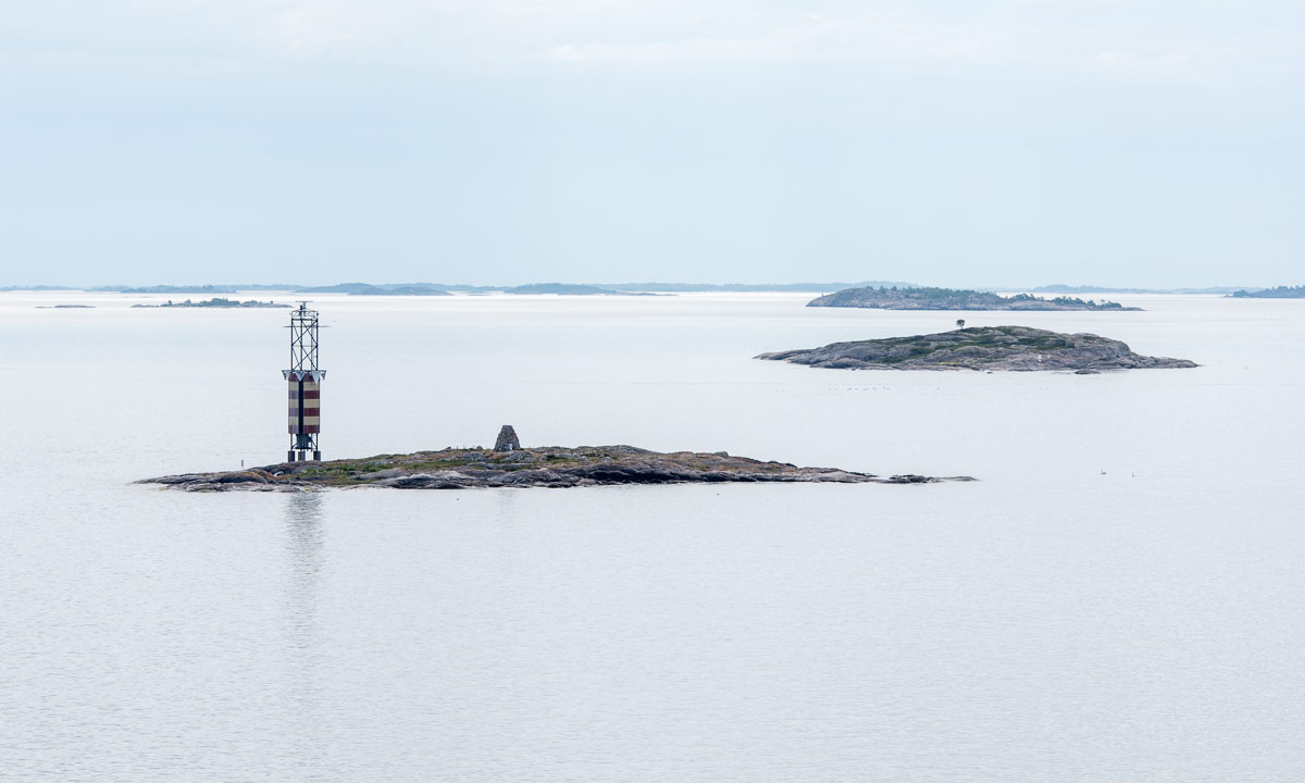
From Björköby it’s not far to Svedjehamn, a boat harbour. The coastal sea was still covered with ice and no boat could be seen. Probably many of the boats were in the red boathouses, that were everywhere.

We looked around, then we followed a path to the large observation tower, which is dark and almost 20 metres high. An eye-catching landmark. Beside of some ice fishers that parked their cars at the coast, we were completely alone. Only seabirds could be heard, mostly the typical honking call of the Whooper Swans.

From the tower we had a nice view both over land and sea. The land was framed with ice, but further out the sea was open. Birds flew around, mostly Whooper Swans and small flocks of ducks (being shooed away by other birds). Suddenly a group of dark birds passed our tower, it was a flock of cormorants.

After a while of amateur bird watching we descended the tower and went back to the parked car. We were hungry and took the way back to the Replot Bridge, where we got a delicious lunch at Berny’s Café and Restaurant.

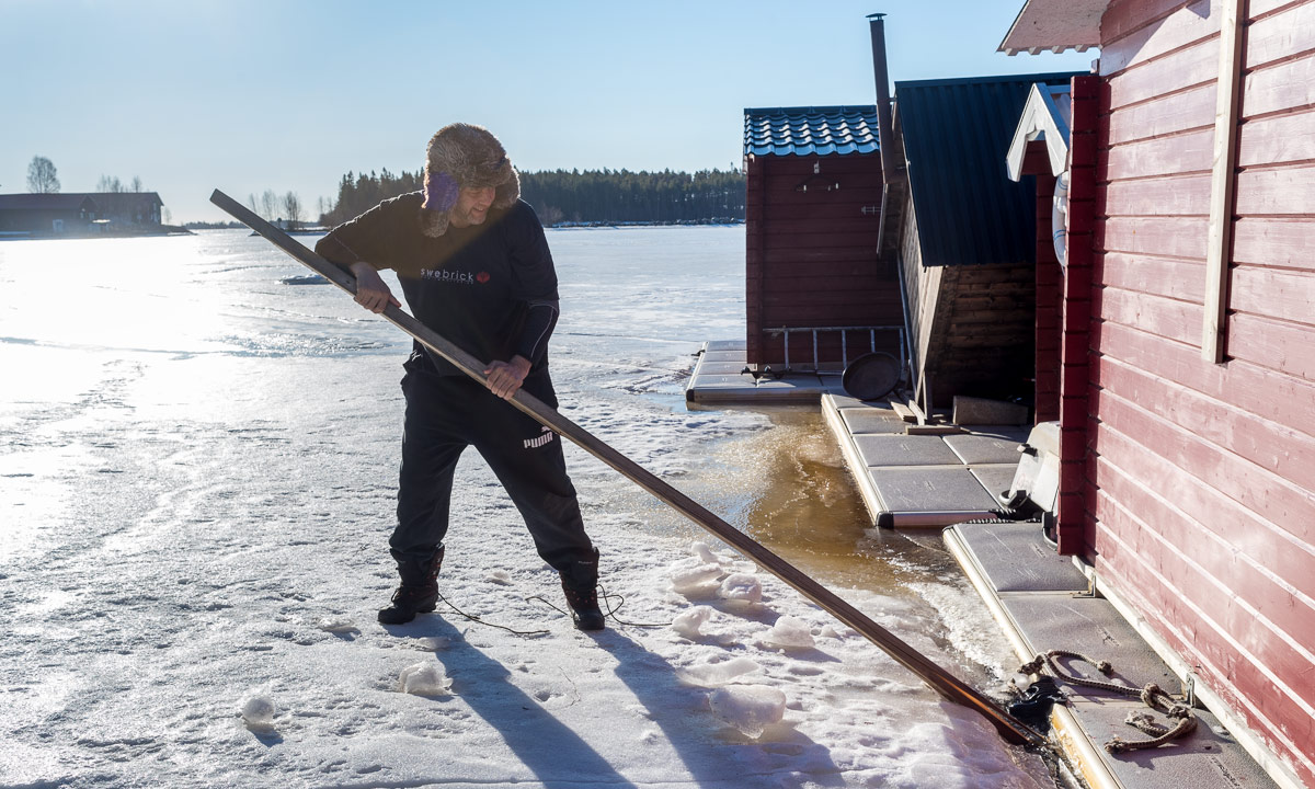
After that we headed for another island in the north. This was quite challenging to drive because larger parts of the way were covered with ice with deep ruts. I had to drive quite slow to keep on the way. In Köklot I made the photo of the only boat in the fishing port, later I just had to photograph the small red hovercraft. I would love to have such a vehicle that can access the sea the whole year round.

I followed the bad road for a while but finally I had to turn because all turnouts were closed. It took a long time to drive back and when we arrived in Vasa we both were tired.

Later this day: A dinner with Asian food, a small coastal walk in Vasa and a bit of luxury: Our flat had a tiny sauna.

3. April – history lessons, old Vasa and Indian food

Already the day before we had decided that we wanted to stay two other nights in the region of Österbotten. We had given Couchsurfing another try. We contacted K.D. that lives in the Korsholm municipality but he didn’t have any place for us. He suggested however that we could meet in the city. So Annika and I went to the monument on the market square where we met K.D.

We got an extremely interesting history lesson about Finland in General und Vasa, while we slowly walked through the city. I didn’t make a single photo, I was too eager listening. After some hours K.D. had to leave but he invited us to the museum Stundars for the next day.

Later we took the car to Gamla Vasa, the old town that burned down in 1852. Some walls, among others of the old church from the 15th century are still there.

Later this day: Indian food and another sauna session.

4. April – a meteorite, two museums and welcoming hosts

Already before the journey we learned about Söderfjärden, a large plain which is an impact crater of a meteorite impact 520 million years ago. The plain lies south of Vasa and we took the car there.

The exhibition at the crate’s centre was closed but outside there’s a model of our solar system. I never walked from the sun to Mercury, Venus, Earth, Mars, Jupiter and Saturn – here it was possible.

We only had limited time, so we took the car to Uranus and Neptune – two small blue-green orbs. Then we changed our perspective back to here and now. We saw the first cranes of the year, more geese and more whooper swans.

From Söderfjärden we drove to the museum Stundars, which is quite nearby. We met K.D. again who had opened the “Smedens stuga” – the cabin of the smith – together with a colleague. We thanked for the day before and had an interesting talk about history and now.

We couldn’t stay for long because we had another appointment. When we had stood on the deck of the ferry three days ago we got in contact with S.. He gave us his phone number and this day we met him in Malax where he opened the Kvarkens Båtmuseum and gave us a private guided tour.

I was deeply impressed by the boat that was used for seal hunting. The hunters lived on the ice for several months with nothing but their boat to live in. We do not talk about the middle age, we talk about the 20th century. The last time this boat was used for seal hunting was in 1963, only five years before I was born!

Through Couchsurfing Annika got in contact with A. and M. who live in Västerhankmo, north from Vasa. We were welcome to live with them for two days, although they had other guests and one of the sons would return from Australia the very same day. We felt honoured that we could stay anyway. We drove to their house, where we were shown a huge couch to sleep over and got in contact with the residents – both human and feline.

Later this day: z-z-z-z

5. April – cloudy weather and a bilingual car trip

The weather was cloudy and we were quite lazy. We had seen a lot the last days and we learned a lot. We learned especially a lot about the Finland-Swedes, the Swedish speaking minority in Finland. Although their nationality is Finnish they have Swedish as a first language. Österbotten is one of the regions in Finland with a lot of Finland-Swedes. In Vasa 25% have Swedish as a first language, in the neighbour municipality Korsholm it is 72%. All people mentioned above are Finland-Swedes and have Swedish as a first language.

The children grow up with Swedish and go to Swedish schools, where they will learn Finnish as a secondary language.

Even the culture is different. When Annika asked for (Finnish) tango events she was told that this would be more a Finnish thing and therefore not easy to find in Österbotten.

It is said, that “the” Finns are much more direct then “the” Swedes who try to avoid any conflict, when possible. I experienced the Finland-Swedes as more to the point than the Swedes and I have to admit, that I enjoyed it because of my own quite direct personality.

Back to 5. April. We took the car and travelled around, first to some other islands.

In Isokyrö we stopped for the old stone church, built between 1513 and 1533.

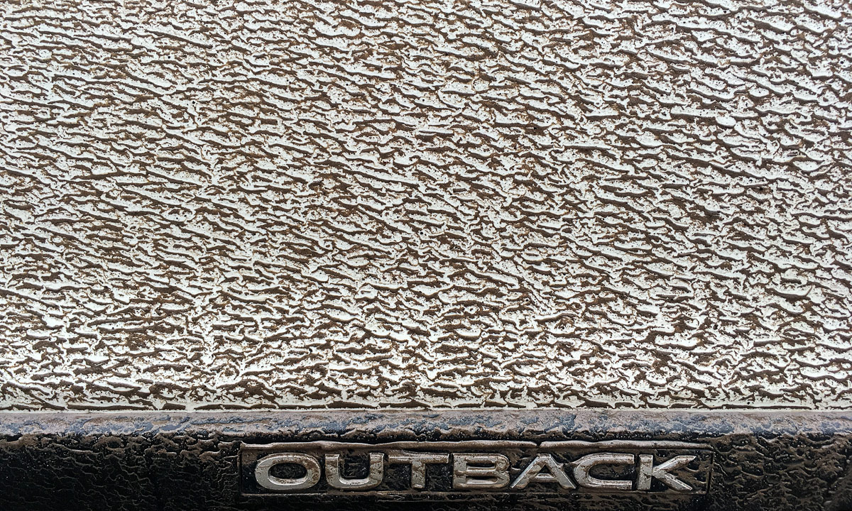
Temperatures were above zero and everything looked grey and dull. The leftover snow was wet and the gravel roads were muddy. When we returned to our overnight place my car looked really dirty – but in their special way the dirt patterns were beautiful anyway.

Later this day: Having a good time with M., A., and family including a very tasty meat soup with homemade bread and petting the cute cat

6. April – with the Ferry to Umeå

6:40: the alarm rings – 7:05: we sneak out of the house (we said goodbye the evening before) – 7:45: we roll on board of the ferry – 9:00: the ferry starts its journey back to Sweden – 12:30 (Swedish time): we arrive in Holmsund, 20 km from Umeå.

Thank you, K.D, thank you S. “för trevlig sällskap” – for nice company!

Thank you, M., A. and family – for your hospitality and “för trevlig sällskap” as well!

Later this day: The first flowers of the year:

An almost secret world of ice

This was my most daring tour on the sea ice yet. This article may not be for the faint-hearted. Spoiler alert: I kept safe and dry!

After an extremely lazy day yesterday I felt today like I had to go out and get some fresh air. Cross country skiing? No, the tracks are probably extremely icy. Jogging? No, the water puddles from the melting snow are deep and I wanted to keep my feet dry.

What about trying to walk to the island Bredskär? There’s a large patch of old ice that should be easy to cross. But behind the islands there could be weak ice.  Didn’t I want to keep dry?

Yes, I definitely wanted to keep dry. So I used a funny combination of equipment today. On the one hand snowshoes for winter walks, on the other hand a drysuit in case of breaking through the ice.

I took the car to the small boat harbour Tjuvkistan, changed into the rubber boots and started my tour from there. The ice was easy to cross even though there were some wet patches. That doesn’t automatically mean that the ice is weak. Mostly it’s freshwater from melted snow or seawater that found a way up through the cracks in the ice. Soon I arrived at the island Bredskär – it’s only 750 m to go. Unfortunately clouds had been approaching covering the sun.

I turned right and walked along the eastern shore. Wind, waves and winter’s coldness had built a ice wall along the shore.

When I reached the eastern tip I had a decision to make. Should I walk around the island and already go back? Or should I dare to cross the sea ice to the next islands Gråsidan and Nygrundet. I chose the latter. I opened the belt of the backpack, checked my ice claws and started carefully crossing the sea ice. Step by step. Step by step. The first half was no problem but then the ice started to look grey. That could be a sign for weak, thin or watery ice. I could see air bubbles moving under the ice with every step. I expected to break through the ice with every step. Perhaps the ice was not weak at all and only covered with water but I was not eager to find out and slowly continued. Step by step.

The ice seemed to get weaker and weaker, thinner and thinner, wetter and wetter. Perhaps it was real, maybe it was only my imagination that gave me this impression. After some more careful steps I finally reached the island Gråsidan. Hooray! Nevertheless only a temporary success because I knew that I would have to go back later on.

I arrived at the northern tip of Gråsidan, turned right and walked along the eastern shore heading south. It was there, where I found the almost secret world of ice. Of course it was not secret by purpose but I guess I was the only one that had managed to approach this special location.

East from the island there was a layer of sea ice and on that there was a huge variety of ice. Large ice floes, heaps of smaller ice discs, round-shaped ice objects and much more was there to see.

It was like an open air art exhibition. An art exhibition of one of my favourite artists: nature. And I had it all for myself. It was not easy to go. Sometimes I had to cross chaotic looking ice fields, sometimes my foot landed in a deep puddle of meltwater. Look at the next photo: This puddle had not only drowned half of my rubber boot but a snowshoe, too.

I was however wrong in one thing. Others visited this world of ice as well: moose. Countless moose tracks covered the sea ice heading seaward. What does a moose want there? There’s only ice and then – already visible in the distance – the open Baltic Sea. The next island in the southeast is more than 11 km away.

Either moose have a very poor sense of orientation or they like ice art just as me. I imagined several moose visiting the various objects and discuss shape, colour and the meaning of the artworks. These visitors however had left, only the tracks were left.

While strolling through the exhibition I already passed another island: Nygrundet, the outermost island of the archipelago. Nygrundet was near the open water. Very near. I approached a huge block of ice and there it was: My personal “Ultima Thule” for today.

After I was sure, that this ice block was connected to the island and no iceberg sailing to Finland I decided to climb the block and make myself comfortable. Although temperatures were slightly above zero it was quite cold due to the strong gale with wind gusts round 22 m/s. That’s round 80 km/h. Brrr! I was glad about my warm anorak that I took with me.

After eating and drinking a bit I decided to go back. I crossed a small patch of sea ice and then went along the island which is connected with Gråsidan by a stripe of land. Unnoticed by me the clouds had moved away and the sun came out. Ice gets a completely new look when sunlit. So I decided to go to the art exhibition once more and turned again.

And turned again to finally return home. On my way back I saw a manmade art object at the shore, but I could not understand its purpose. I preferred the tiny pine trees sticking out of the snow. Then I crossed the island Gråsidan from east to west (less than 200 meter).

The last photo clearly indicates that I hadn’t been in the Arctic. It’s still Skelleftehamn. On all of the mentioned islands there are summer cottages. The cottages on Nygrundet and Gråsidan were empty due to the difficulties to get there.

I started to look for a better place to cross the sea ice back to the island Bredskär. I had felt quite uneasy while crossing the ice to Gråsidan and I hoped for better ice. To make a long story short: I found a longer, but better and easier way.

I was relieved when I arrived Bredskär. Now the ice probably would be thicker and safer. I walked along the island somewhere between sea and land. There where a lot of very wet patches but on safe ice. Now I only had to cross the sea ice once more, then I would arrive on the mainland and at my car.

Here a lot of water, partly frozen, covered the ice. Snowmobiles and ATVs had left deep traces and wheel ruts. I started getting a bit impatient and instead of taking the same way home I turned left a bit earlier. First it went well then I had to plunge through surficially frozen water and slush. With the snowshoes that was quite exhausting but the shore came nearer and nearer.

I could spot my parked car and the snowy slope where I had to go up. 100 metres to go. 50 metres to go. 10 metr… – crash!

My right leg went through the ice to the upper leg. It was not weak ice, I just oversaw a large and broad crack. The rubber boot was soaking wet but not myself. The attached stockings of my drysuit had kept me dry. It’s funny anyway that this happened just seconds before finishing the tour.

Probably I will keep a bruise on my knee for some days as a nice memory of this very special inter-season snowshoe tour on the Baltic Sea. And a fabulous tour it was.

Equipment

Directly translated from my packing list with some comments.

  • smartphone + powerbank + charge cable + waterproof bag (the powerbank to be able to load the smartphone in emergency situations)
  • camera + memory card + cleaning tissue + reserve battery (all packed in a waterproof Ortlieb bag that I wore in front of my breast)
  • drysuit (to keep me dry in water. Only head and hands would get wet)
  • rubber boots (I chose my huuuge Russian rubber boots with thermal inner boots
  • snowshoes (flexible enough to work with the rubber boots)
  • 2× balaclava (for the head – one comfortable made of fleece, one tight and waterproof)
  • 2× gloves (one pair made of Powerstretch fleece, on pair of waterproof neoprene)
  • isdubbar – ice claws. (The most important thing! Two handles with spikes that you can use to pull yourself on safe ice after having broken through)
  • provisions (A cinnamon bun, chocolate and a coke(!) )
  • Cabela’s anorak (the insulated anorak with the fur trimmed hood you can see on my selfie)
  • waterproof bags (I stored everything in waterproof bags – from the other pair of gloves to the car keys)
  • sunglasses (today even used as wind protection)


March snow at the coast

Today I finally had to work with my it job again.

But before that I just had to take my camera and drive to different places by the sea. I was curious how it would look like after the snowfalls of the last days. This morning between 75 cm and 80 cm of snow in my backyard and we are talking about the average, not the snow drifts.

1. Peninsula Näsgrundet

Normally the coastal line is quite visible here. Either you see stones sticking out of the rocky coast or you can spot the raised ice edge. Today you mainly saw a white plain. Only some of the largest rock and some brown tufts of grass were sticking out of the snow. I really had to look for motives to avoid images with a plain-white bottom half.

I would not dare to enter the ice because you cannot see its thickness. Probably there are weak spots that wouldn’t bear my weight.

2. Boat harbour Kurjoviken

On the roofs protecting the two wooden boats there was hardly any snow. Probably it had been too windy. Parts of the outside furniture of the restaurant Sjökrog were buried deepely in the snow. There was also a completely buried table, but that would have given a very boring photo.

3. Nameless boat bridge, Rönnskär

The boat bridge normally shows nice contrasts between the wooden construction and the water, whether covered with ice or not. Even here the snow made it all the same today: snow everywhere reduced the contrasts radically.

Now I was satisfied enough to start working, but first I had to shovel snow. I had already cleared the garage driveway last Sunday, not I had to dig a bay into the snow so that the postman could approach the mailbox by car. Phew, that was work, round about 1.5 m³ of frozen snow had to be moved and thrown in my front yard.

Snow makes everything beautiful, it’s only a matter of the amount.


Last day of February – farewell sea ice

Yesterday I stood on the ice edge of Kågnäshällan. It was warm and felt like the end of April. And so it looked like, too, because large parts of the Bothnian Bay were free of ice. Only protected bays and shallow waters round the islands were still frozen.

It became colder and stormy in the night. It even snowed a millimetre.

When I got up this morning it was -4 °C and still quite gusty and stormy. At 8 o’clock I took the car to have a look at the ice conditions.

I passed the nearest bay Kallholmsfjärden, just 400 metres from my house. Some ice fishers were sitting on the ice, but only some hundred meters from open water. I however wanted to drive to Näsgrundet, one of my favourite places. Yesterday afternoon the sea east of this peninsula had been completely covered with a new ice shield that had been created one week ago. Today it was … well, different …

Gale-force wind gusts tugged at my hood. Waves splashed sea spray and tossed pieces of ice onto the ice walls in front of the coast. Ice floes floated to and fro, cracking, shaking, turning, breaking. Sometimes I could feel the vibration of another wave hitting the ice wall I was standing on. Some of the ice already had been squelched to slush. I cannot remember such an impressive view of the forces of the Baltic Sea in winter time. Farther away a ship was leaving the port, accompanied by a tug boat and the small icebreaker Baus.

I tried to make pictures of the say spray of the waves. Not easy …

Behind the curtains of spray waves came rolling and small and large ice floes pivoted and danced while going up and down.

After 45 minutes the Baus came back heading for the port.

Partly I was taking pictures, partly I was just enjoying the energy of the elements and listened to the different sounds. I tried to make some videos, but all you can hear is the swooshing wind at full volume.

After one and a half hours of photographing I left this scene and drove to the small boat harbour Tjuvkistan nearby. Here the ice uses to be safe to cross to the islands Norrskär and Bredskär until the end of March or even mid-April.

Well, not this year. Even here the ice layer was being destroyed by the waves. The northern wind blew the ice floes away, so they will not freeze together again, or perhaps in Finland.

When I returned home I passed the Kallholmsfjärden a second time. The ice fishers were gone – there was just no ice left to sit on and fish from.

So, the sea-ice-season is over, four to six weeks earlier than usual.

No kayaking today

Yesterday the Baltic Sea was open. Some ice floes drifted in the waves, the rest between mainland and the island Gåsören was open water. Just the photo from yesterday afternoon one more time:

When I saw the open see yesterday I thought about kayaking today. Temperatures below -15 °C were expected. What to wear beside of a dry suit? How many layers?

I started to dig out the door and gate of my garage to be able to get my kayak. That was hard work. The upper layer of the frozen snow that had slid from the roof was as hard as concrete. Even the avalanche shovel with the metal blade could be hug into the snow centimetre by centimetre. But finally I made it, my kayak was free.

Today at 7 o’clock the outdoor thermometer showed -18 °C. Again – what to wear on a kayak winter tour? Two layers of underwear? The winter anorak? The earflap cap made of thick polyester fur? Well, first let’s check the situation by the sea.

Oops …

The sea had been frozen overnight. A stripe of at least several hundred metres was covered with soft and thin ice, exactly that type of ice hardest to handle when sitting in a kayak.

Kayaking plans cancelled! Time for another photo.

Meanwhile in Skelleftehamn – snow and sea ice

Arrival home in SkelleftehamnI expected the worst in Skelleftehamn. The worst regarding winter. I wanted to have a real one – it’s mid-February – but had heard about the warm temperatures last week. Three days with temperatures round 7 °C, at least in town. But I was lucky, it hadn’t rained these days. The snow had fallen together but was still there. All minor streets where still white with some fresh snowdrifts from today’s strong and gusty wind and in my backyard lie still round 55 cm of snow.

Of course I had to shovel away the snow before I could use my car. Its a car with all-wheel drive but no snowcat. Although the snow was hard it was easier than expected.

The special thing about a trip with the Hurtigruten ship is that the Norwegian Sea is free of ice the whole year round and most parts of the Barents Sea, too. The Bothnian Bay – the northernmost part of the Baltic Sea – however is covered with a thick solid layer of ice. That’s what I thought until I read a Facebook post today:

Öppet vatten runt Gåsören. – Open water round [the island] Gåsören.

I could hardly believe it and took the car to the coast. And yes – large parts of the sea were free of ice, even the ice floes had gone beside of some remains. I guess there won’t be a ski tour to Gåsören this winter.

Two weeks ago I had made ski tours on the Baltic Sea with Chris. Although there’s solid ice left between the other islands I doubt that we could do the same tours today.

Here’s a comparison of the ice situation today and two weeks ago:

Legend:  fast ice |  very close or compact ice |  open ice | open water
Source: SMHI Sea Ice – Archived charts and reports