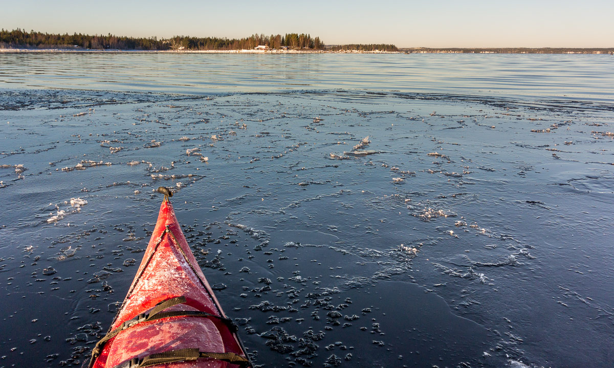
Pancake ice


Pancake ice at the Baltic coast near Kågnäsudden today.
Pancake ice at the Baltic coast near Kågnäsudden today.
Today I was out and did some canoeing. There was a special reason for that: Johan from Sweet Earth wanted to make a short film about kayaking in wintry conditions for Skellefteå kommun, the municipality of Skellefteå. He asked me whether I wanted to be the canoeist and I accepted gladly. Since the weather forecast looked good for today we planned to make the film today.
And the weather was good – it was fantastic! When I woke up at 6 o’clock, the sky was still dark but starry and completely free of clouds. The thermometer showed -13.8 °C – the coldest temperature in Skelleftehamn this season. I was curious about Storgrundet, where it happened to be open water the day before. How would it look like today?
Some minutes later I stood on Storgrundet’s boat bridge and lit my strong flashlight. As almost excepted the water has completely frozen over last night and the rim of the new ice was about 3 cm thick. Too thick to break through with my kayak. Anyway, it could be less thick a bit farther away, I considered.
At 7 o’clock Johan arrived and we discussed the possibilities:
We decided for Plan A. I fetched the kayak from the garage and pulled it through the deep snow to the street where I put it onto the trolley. I pulled the kayak to the beach while Johan followed by car filming. Soon I arrived at Storgrundet’s parking place, but not Johan. Some minutes later my phone rang: Johan’s car got bogged down in the snow and he had to shovel it free. I returned to give him a push. Luckily his car was free soon again and we arrived at Storgrundet for sunrise.


I took off my winter anorak and slipped into my waterproof immersion suit – ugly but vital. I removed the kayak from the trolley and pulled it to the end of the boat bridge. Near the shore and round that boat bridge the ice was white, it was older and thicker. Some metres away it was transparent and you could see the sea bottom. That ice was less than 12 hours old. I positioned the kayak at the rim of the white ice that bore my weight and entered slowly the fresh ice. It took just some steps and – Splat! – the ice broke and I stood in chest deep water. Well, that came not unexpected. That’s why I had the waterproof suit on and my isdubbar round my neck.
“Isdubbar” or ice claws are sharp spikes with handles. These are attached to a cord to be worn round your neck. If you fall through the ice you can use the spikes of the ice claws to pull yourself out of the ice hole back to safety. A must have when going onto the ice in early winter or unknown terrain!
I managed to crawl onto the ice even without the ice claws, because the immersion suit has so much buoyancy. I put the kayak onto the little ice hole and climbed in. Unfortunately the kayak wasn’t heavy enough to break the ice. I tried and pushed, wiggled and jiggled until I managed to forge ahead perhaps ten meters. Anyway I only succeeded into bending down the fresh and soft ice, instead of breaking it. Since the paddle had zero grip on the wet ice I couldn’t steer at all and turning was completely impossible. Finally I gave up and pushed myself backwards with the glove protected hands.
When I came to the older and slightly higher ice I was kind of trapped. I couldn’t push myself backwards hard and fast enough to come up onto the safe ice surface. I tried several times and at last I just left the kayak – Splat! – went through the ice again, crawled onto the safe ice and dragged the kayak back to the boat bridge.
The result: Paddling on ice: round 25 m. Paddling in water: 0 m. Baths taken: 2. Photos taken: zero. I hope, that Johan filmed my abortive efforts. It will make me laugh watching it.
But as I said, there was Plan B2:
500 meters to the northwest the Baltic Sea is not in the lee of the island Storgrundet anymore. Here at the bay Flunderviken it usually takes much longer for the water to freeze over. While Johan had to take the save way on land I could go straight ahead by crossing the ice with my kayak in tow. First I had to plunge through soft ice and water again but then the ice was of the older and stronger kind and it was easy to get ahead. I knew, that Johan would be slower and I would had time to make some pictures.


Anyway even Plan B2 was in danger: Flunderviken was iced, too. At least I could see open water 100 or 150 meters ahead. Perhaps the ice would be weaker and I could go through the ice howsoever and reach open water. But first I had to wait for Johan who had to stomp through more than knee-deep snow to arrive. Time for another photo, time for going through the ice again, this time only knee-deep. Even here the ice was 3 cm thick – too thick to paddle.


Soon Johan arrived and I made my reservations. I didn’t believe in “ice-paddling” that far. Johan got an idea: Wouldn’t it possible to use the ice claws to push oneself forward? Well, I could try. The idea appeared to be brilliant. It was quite easy to push oneself forward, even it was hard work for my non-existing arm muscles. It went great until the ice got weaker and the kayak started to break it. Here it was hard to reach ice solid enough to pull oneself forward with the spikes. It took a long time and I had to take breath several times until I reached the last meters of the ice cover where ice was so thin that I could use the paddle again and finally I was free. Hip, hip, hooray!


Now I was able to paddle freely as on a warm summer day. Beside of the floating ice needles. Beside of wearing my heavy immersion suit. Beside of the snow that covered all shores. Beside of the ice crust on my kayak …
And beside of my exhaustion because of the struggles traversing the ice. Anyway I wasn’t here for a long tour but for being filmed. I didn’t want to get too far away from Johan who was landbound. Therefore I took just a short round and made some more photos before I started back.


I followed my old route where the ice already was cut and it was much easier to get ahead. Soon I reached the thicker ice – first still cracking under the weight of me and my kayak, then thick enough to bear us without any complaints – and then the shore where I had to plunge in into knee-deep water for the last time before I went ashore.
It was great fun testing out the limits of winter paddling in Skelleftehamn today. It won’t be the last time that I do such. However this is only possible with proper equipment. Without immersion suit or dry suit, isdubbar and such this tour wouldn’t have been possible at all.
So, folks: Be crazy and be safe!
And – as promised – the link to the video.
Tomorrow I want to canoe. So I checked the potential starting points today. Where could I set in my kayak?
That’s where Skelleftehamn’s pilot station is. As expected the Baltic Sea is completely open. Here it would be possible to start the tour, but I had to go 2.5 km.
The nearest place, only 600 metres away, but this small bay has been already ice-covered for some days.
We’ll, this should rather be frozen over, too, but to my surprise there was a broad band of open water left. I guess that the water level, that changed several times the last days prevented parts of the water surface to freeze over. The distance to Storgrundet is 1.6 km and I think I’ll try out this place tomorrow.

Anyway I’m not completely sure, if there will be open water tomorrow in the morning, too. Today has been the first day, where the temperature dropped below -10 °C and maybe there will be ice on today’s open water tomorrow. Either a bit that cracks when you traverse it by kayak or a bit more making it impossible to squeeze through.

Seasons are a bit in between. The open sea is completely free of ice beside of some sheltered bays having a thin, but solid ice cover. When such an ice cover breaks in the waves, pancake ice is formed. Pancake ice are ice floes that move, twist and turn, scrubbing each other until they are round, like pancakes. I found some of them when I drove to the peninsula Rönnskär to have a look at the sundown. They floated in the sheltered boat harbour near the shore.

This article is part of the series “2016-11: #snowember16”.
As yesterday I took the car to the hill Bureberget, this time with skis and snowshoes. I had thought that the biggest challenge would be to park the car – not easy if there are only snow walls on the left and the right off the road, but I was lucky, a side road was cleared and I could park the car there in front of an old, wooden house buried in the snow.

I decided for the skis, changed shoes, put on gaiters, strapped the backpack on and put on my skis. After following the main road to Burvik a bit I bent left into the road to the top of Bureberget. The snow has settled a bit and was less high than yesterday. Soon I found a nice way downhills – my first “ski-run” this season, perhaps 20 seconds long. Of course I had to climb up again. That was partly not so easy between trees, rocks and quite soft snow where I sank down to my knees quite often even with the skis on. I found a steep but nice passage up that led me to some kind of bridge or ladder crossing a small ravine. This part I took without my skis …
After I had succeeded the “winter climbing challenge” I stood on a huge rock, almost up on the level of the top again. I took a detour to the forest and was soon back again.
This ski tour was quite short. One of the reasons was, that I didn’t find nice motive for photos today. It was very windy and all treetops were bare of snow. Many pine needles and pieces of bark lay on the snow which made the snow looking old and dirty, even if it was just one day old.


But anyway, it’s always great to be out and so it was today! And even better, when the sun comes out.

2. The coast of Storgrundet
When I was back in Skelleftehamn I didn’t drive home directly but to the coast of Storgrundet. I was curious how much ice would cover the part of the Baltic Sea between island and mainland. There’re still patches of open water, but most of the water is covered with ice. I guess that I have to look for other starting points, when I want to paddle kayak in the weekend.


It was only some degrees below zero but the strong winds made me shiver and I was very glad to had a warm down jacket with me and put the hood on tight. Brrr, autumn is definitely over.
“BING-BINGA-BINGA-BING-BING-BING-A-BINGA …!”
… yells the alarm on my mobile. I open my eyes, still partly caught in my dreams. Then I realise: It’s 5 o’clock in the morning and I’ve planned a paddle trip today. Out there it’s still pitch black and reluctantly I get up and get some breakfast. I’ve already packed the day before: dry suit – neoprene boots, gloves and hood – camera in a waterproof bag – water and chocolate. The compass and the live vest are already in the kayak. I leave, pulling my kayak behind on its trolley and the temperature is -4.5 °C – the coldest day since April. Round half an hour later I’m ready to start the tour. The sun hasn’t risen yet and some pink clouds hang in the blue sky.


At the sandy beach I drag the kayak into the water, lay the paddle on both the boat and the shallow ground to avoid tipping and climb in. I do some strokes, unfold the rudder that helps my steering the kayak and turn right. It’s low water and much more stones and rocks are visible as usual. I turn right again to paddle between the island Brambärsgrundet and the mainland. After that I turn left again and see the horizon and an archipelago of stones. I have to make my way through and more than once I hear the typical clicking sound, when the sea is so shallow, that the rudder at the rear touches ground and is lifted up.
The colours start to change: From light pink to something you could call apricot to warm orange. And then the sun starts to rise. It’s not that I’ve never seen sunrises before, but still I love to watch.


The sun rises a bit higher and starts to illuminate the colourful trees on the island Storgrundet which I’m approaching. Before I reach that island I turn right again and head to the open water. All I see in front of me is water, waves, the sky, clouds and midmost: the horizon. It looks like I just could paddle straight ahead to the horizon for ages. Probably it would take ages: it’s round 150 kilometres to the Finnish mainland.


So I turn left again and paddle along Storgrundets outer shoreline, go round the western peak and to the same beach were I started my tour one and a half hours before. A quite short, but pleasant kayak trip.

I go ashore and drag the kayak to the beach. It’s still below zero. The spray water on the kayak is frozen and there’s hoar frost on leaves and wood, especially in the shadowy places.


Now I exchange the dry suit for pants and jacket and the neoprene hood for a woollen cap. Dry suit and such is great for protection in case of falling into the cold water, but the “normal” clothes feel much more comfortable. I make a last photo of the beach and the island Storgrundet in the back, then I return home dragging the kayak behind.

At 9 o’clock I start my normal work.
“New Year’s resolution”: Be more outdoors in my everyday life, even if it’s short.
Two photos of the small wooden, floating boat bridge at Storgrundet, the nearest beach from my house in Skelleftehamn. Both are made today.
One is a snapshot, made 10:30 in broad daylight. The sky is bright blue, the birch leaves are still yellow, slowly turning brown. A boat has just put out to the near island. The sun still warms, but it is windy and the air is fresh. Tiny waves make the boat bridge wobble and you can hear the waves gurgle.

Almost twelve hours later, att 22:08 I make the second image, this time with a tripod and 10 sec exposure time. The sun went done at 6 o’clock and the temperature has dropped to 4 °C. A cloudless and starry sky arches above the near island and the rests of a polar lights are flickering above the horizon. Just as this morning the boat bridge is wobbling in the tiny gurgling waves – that’s way this photo is jittered.

I like either views, both the autumn leaves in the sun and the polar light in the night. However while I enjoy the autumn days just as they are, the polar light increases the anticipation of the coming winter – still months away, but coming for sure.
It doesn’t happen often, that you can make boat trips from Skelleftehamn, were I use to live. Only one week once a year the Laponia Rederi from Luleå comes down to Skelleftehamn for some cruises. Last Saturday Annika and I took the opportunity to attend a five hour cruise to Bjuröklubb, where I’ve been quite a lot, but never by ship. When we arrived in good time before 11 o’clock people already started entering the small ship.
We boarded, too and thereby lowered the average age some years. I sniffed around the boat and got the permission to enter the bridge for some photos.


Five minutes before schedule the ship put out to sea, cruising along the industrial peninsula Rönnskär.


While Annika and I were standing on the top deck looking at the sea, the islands, the sky and the waves, all other people stayed inside and started focussing on the main topic: the lunch buffet. Anyway I have to admit, that especially the salmon was extremely delicious, and the bread as well.


I once thought about making a kayak trip to Bjuröklubb, an exposed peninsula and the easternmost point of the county Västerbotten. It would take me some days, since for one thing I’m slow and for another thing I would follow the coastline and never dare to take the much shorter direct route long away from the mainland. The ship, however was fast and took the “directissima”. Therefore it took only 90 minutes to cruise there.


At the small harbour we all went ashore and the ship continued to a larger harbour nearby where it waited for us. We got a guided tour and went up to the lighthouse where we left the croud for a good reason: Just that day was the International Lighthouse and Lightship Weekend, the only day where the lighthouse – which is still in use – is open for visitors. I went up, waiting for the other visitors – max 4 at the same time – to leave and made some photos. Not only the cut glass mirror construction was incredible but the colourful reflections of the sunlight, too.


Since we already left the group we took a hike to the other harbour, where we entered the ship again. Why it took us more than half an hour to walk for just some hundred meters? Well, there were blueberries, there were raspberries … and we picked and ate a lot of them.

The crew untied all the ropes connecting the ship to the land. I’m sure they are nautical terms for those ropes, you are free to post their proper names in the comments. Then the ship started, fetched the other passengers at the other small harbour and headed back to Skelleftehamn. Annika and I sat on the upper deck and enjoyed sun, clouds, wind, and waves as well as the view on the islands Skötgrönnan and Gåsören.
Ninety minutes later we arrived again in Skelleftehamn, where we came off the ship, while one of the crew played farewell music on the accordion.


Conclusion: A relaxed cruise and the opportunity to play tourist in my adopted homeland for one day.
You just leave Umeå by car on the E4, head southwards to Örnsköldsvik and continue a while, leave the E4 in direction Köpmanholmen and Näske and continue to “Entré Nord” (entrance north). You park your car, shoulder your backpacks and follow the signs. And soon you stand amidst the fantastic forests of the Skuleskogen National Park.

Annika got visit of her friend Johanna last week. A good opportunity for us to spend a weekend together in the Skuleskogen National Park. Since our planned tour for Saturday was not so long, we started our hike not until 12 o’clock. In addition to the usual stuff as rain jacket and spare clothes we had a lot of food and water with us. Much water, since we weren’t sure if we would find any near the cottage – much food as potatoes, sausages and a lot of salad because we just wanted to have a bit of luxury.
The first part of the trail through the forest was fantastic, almost magic. Old trees bespangled with lichens, big rocks coated with green moss and from the left a pale light signalising that the Näskefjärden – part of the Baltic Sea – is not far away.


And “not far away” means: just a few meters.

Annika and I looked forward to take a bath, but first we wanted to reach the cottage on the islands Tärnättholmarna to leave some of the heavy luggage there. When Annika told me about the beautiful cabin on the inshore island of the Tärnättholmarna I wondered how we would come there. Is there a bridge? Do we have to take a boat? Wade? Jump? Swim across? Anyway my wonderings were useless: Since the glaciers of the last ice age had melted any, the land has been rising again – still 8 mm a year! This phenomenon is called post-glacial rebound. That’s why the Tärnättholmarna have been islands in older times, but nowadays are connected with the mainland by a broad band of sand.
It’s not far away to the cottage and we reached it within a good hour. We left most of the food, most of the water, some spare clothes and our sleeping bags and continued much more lightweight. (Beside of me, who had 5 kilos of camera equipment with me, but that’s my problem and most of the time I don’t complain …)

We continued the forest trail southwards. It’s an easy way but not the most interesting part of the National Park in my opinion. Anyway we walked still along the shore and the beaches were sandy and the water was clear and the sun shined … . Time for Annikas and my long yearned-for bath. The water was chillier than expected but so refreshing!


After we have dried in the sun we continued our Saturday hike, now heading north. Here the trail climbs round about 265 meters, if you take the eastern variant. That may not sound much but the change in the landscape is really impressive:
Starting just 200 meters away from the sandy beach you walk through a dense forest of primeval old, large trees. Sometimes the trail is covered with cobblestone-like stones, sometimes with a maze of tree roots, sometimes it just leads over jogged rocks. All of the sudden, the path turns right, leaves the forest and you stand on solid red granite rock. You look up and see more rocks and – yes! – that’s your way up! You follow the marks, sometimes by walking, sometimes by climbing up the steep or rugged passages.


Finally we were up on a rocky and bald plateau and had amazing views over the mountainous forests in the west and the Baltic Sea with its many islands in the east. Unfortunately it was quite cloudy when we went there and I hardly took any pictures. Between the next two photos lie 34 minutes and about 50 metres in height. The descent however is far away from being easy. You have to climb down through rocky terrain with a gradient of 50%.


And then you stand at the upper entrance of the famous Slåttdalsskrevan. Wooden stairs are leading down into that ravine where the trail continues downwards. Inside the ravine it’s so dark, that the contrast to the sky is too high for my Nikon D-800. Either the rocks are just black or sky is just white.


After leaving the ravine we still had to climb down, now again surrounded by forest. After a while we came to the lake Tärnättvattnen. The sky brightened up again and the view of the lake mirroring the blue sky was just marvellous. Johanna, Annika and I agreed in staying at that place overnight, when we should be there once again, even though that cottage is much smaller than our choice.


Now we were not too far away from our todays destination: The cottage on the peninsulas Tärnättholmarna. But even 2.5 kilometres can be demanding if there is another steep and rocky crescent. And so it was. If this passage was in the German Alps there would have been several warning signs about the necessities of alpine experience. In Sweden however you rely on the people, that they know, what they do. It seems to work well.
That’s how a part of the descent looked like when looking back:

I was really exhausted when we were “home” at our cottage, that we shared with two really pleasant Swedes. Annika proofed her abilities of outdoor-cooking while Johanna, though being a total beginner, showed her strong woodchopping skills. The only fault: the sausages were quite disgusting. I shouldn’t complain, it was me, who chose them … . After our outdoor dinner at the fireplace and some talk we all went to bed, glad to stretch the tired back and limbs.
The next day? Nice, smooth and relaxed: A breakfast with yesterday hard-boiled eggs, homemade bread, hot chocolate, and Västerbottens Ost, a local cheese. Strolling around the peninsulas – eating blueberries – sitting on the rocky shore beside the Baltic sea – eating some more blueberries – taking it easy. Taking an outdoor lunch with roast potatoes (with the rest of the sausages) and salad. I took a short nap and after that we packed our now quite empty backpacks, cleaned the cottage and went back to the parking place, where we arrived one hour later. The most challenging part of the day was my car drive back to Umeå, i was so tired!
It was a fantastic weekend. Thanks for the nice company, Johanna and Annika!
Some Sunday expressions in and round the cottage:


Last week I’ve been in Mosvik (Norway) to visit friends. Yesterday I drove back home, not directly but with a detour via Nordli and Røyrvik (Norway) and Stekenjokk, (Sweden).
According to google maps the direct way is 671 km, taking 8 h 38 min. With the detour it is only 67 km, but 1 h 46 min longer. That says a lot about the small and steep gravel roads near the Swedish–Norwegian border …
For me the journey didn’t take 10.5 hours, but more than 15. For one thing I don’t drive fast, especially in Norway and for another thing I took many smaller rests for taking pictures as well as a lunch and a dinner break. I left at 9 o’clock; at quarter past midnight I finally was home again. Total distance by car: 757.5 km.
See my travelogue of the journey by clicking the first image and navigating through the images. Swipe on touch devices and click or use arrow keys on other computers.


By the way: After nineteen articles without any photo with snow, this is the first article showing at least some patches of snow again.
It’s a bit funny. Although the internet weather forecast rarely correspondents with reality, I check it anyway. Then I at least try to ignore it.
Last sunday, when Annika and I considered what to do, the forecast promised sun for two or three hours, but rain showers for the rest of the day. We decided to take the car to Norrbyn 40 km south from Umeå and the 11:30-ferry to the island Norrbyskär. If it really rained, I could at least try out my brand new rain jacket.
11:20 we were on board of the ferry Norrbyskär and soon the little ship put out to sea. The trip didn’t take long, it’s only 2 km to the island. I just love boat trips, it always feels like holidays when you stand on the ship’s bow, feel the airflow and look at the blue sea.


Norrbyskär consists of several islands connected with dams and as we experienced later even another possibility to cross the water. We went ashore with the other guests and headed left on the island Stuguskär. The way is framed by quite large brick houses. Most houses in Northern Sweden are made of wood and for us the brick houses looked more like a small coastal town in Germany, not a North Swedish island. The broad way ended soon, but a path continued through the forest and led us to a tiny bay. The single summer house standing on stilts brought us back to Sweden: it was wooden and painted red.


We continued to a place called Calmarn, another part of the island. The soil along the bay was brown and very bouncy. I had to look twice until I realised that the soil was neither sand nor mud. As many other places Norrbyskär had a huge sawmill in former times and this bay was completely covered with a thick layer of sawdust that gave you the feeling of crossing a huge trampoline when you walked on it.
We continued the path and entered the forest again. Soon we stood on the rocky north point of Calmarn, where we took the first rest. We sat down on a big rock, looked at the sea and enjoyed the blue sky and the warm sun. No rain in sight yet.


Now we went back the whole way until we almost were at the shipping pier again but continued the main road that connects the islands Stuguskär and Långgrundet. The street ends at a place surrounded by two white wooden houses and a bell tower. The entrance of the main building was labelled sommarkyrka – “summer church”. The ferries that connect the island with the mainland are going only between late april and early october – hardly more than 5 months, so probably this church is only active these months.


We went around the church where we found the Tannskärsstigen, a forest road on the peninsulas Tannskär and Truthållan. Sometimes the path was near the shore and you could see water lingering through the trees. Sometimes the path looked like leading through a huge and dense forest, even if Tannskär is hardly 500 meters in diameter.


It got warmer and warmer and we longed for a bath. The first beach was not actually crowded, but the nice places were occupied and so we continued our walk. The second bathing place wasn’t completely deserted neither, but big enough for us to find a place. A pair sitting on a wooden bench, some boats, some people on the pier, some kids in huge orange life jackets. We drank some water, ate some sweets and decided to take a bath.
Brr – the water was still really cold but so refreshing. So delightful! After the bath we laid down on the wooden pier and the sun dried us in a short time.


We continued the circular track and soon approached the summer church again. We went a bit back and crossed another dam to reach the island Stengrundet. Here’s a huge campground of the YMCA (in Swedish: KFUM). We had a look at the climbing crag where people with climbing harnesses and helmets climbed ladders and balanced on ropes, but soon we went to another shore were we had a look at the blue sea with its small and tiny islands.


We went back to the campsite, found another path through the forest and followed it, this time in direction north. The north peak of this island is extended by a quite long breakwater made of big rocks. Again a nice place to rest. In the east we could see the tiny island Burgrundet. It looked spooky. Some leafless dead trees and black birds. Crows? Dead man’s island? No, it weren’t crows, but cormorants sitting on the bare branches of the dead trees.


In the south we could see some wooden wrecks in the shallow water between Stengrundet and Långgrundet. On the satellite photos it looked like shipwrecks – almost like a ship graveyard. We went back – first along the shore then through the forest. It took a while but finally we found the path to the shore where we could see the wrecks of some twenty meter long wooden shipwrecks – an amazing view!
I already started to check the time because we wanted to reach the 18:15-ferry. The museum, which is not far away from ferry dock, was already in view and hardly hundred meters away, but on the other island. To reach the museum by foot we would have to go two kilometers to use the dam between the islands. But there happened to be an alternative:
When we looked at the shipwrecks we found a big wooden raft, tied to some cords that were fixed to the shore of both islands. Apparently it was possible to enter the raft and just pull oneself cross the water. After some considerations whether it would be (a) possible and (b) permitted we entered the raft, took the soaking wet cords and pulled ourselves over the water. It didn’t take long and we were able to hop on shore. We went into the museum, bought lemonade, strolled back to the ferry dock, sat in the warm sun (still no rain cloud in view) and waited for the ferry. A short boat trip to the mainland ended a wonderful day on the island(s) Norrbyskär.


This felt like an ideal day trip and – even though Annika and I both live in Sweden – a bit like Sweden in a nutshell: ferry trips and tiny islands, sailing boats and motor boats, a museum, a restaurant and a kiosk, stony and sandy beaches, huge rocks and forest paths, not to mention many flowers, ice cream and the first blueberries (still very sour!).
Conclusion: fully recommendable!
Official Site: visitnorrbyskar.se