Tussilago 2023

Just for the records: The first Tussilago that I saw this year was in Umeå on 15 April. There is still a lot of snow but on some of the southern slopes the snow has melted away.
Just for the records: The first Tussilago that I saw this year was in Umeå on 15 April. There is still a lot of snow but on some of the southern slopes the snow has melted away.
After a breakfast in the sun heated winter garden Annika and I dress for a kayak tour. Special challenge today is not the frozen bay but the deep snow in our garden. I plunge through the snow, Annika is taking snowshoes while dragging the kayak behind. We are walking over the ice to the small skerry island Lillskär and then turn left until we approach open water. There we start the tour. I give Annika a push, then be both are sitting in our kayaks hopping forward until we reach open water.


We paddle to the islands Obbolstenarna. The way there is fast, a clear sign that we have tailwind. And true, the way back takes much longer. Yes, we are cold, but the winter garden is very warm and soon are we.


A friend from Stockholm is visiting us today. Time to dig out our barbecue place. The two benches are covered with 20-30 of snow and it takes a bit of digging, until they are usable again. On the photo you still can see last day’s ski track crossing the bench.

It gets cold and we have moved to the winter garden again. Blue sky, blue sea, blue snow, blue hour.

A bright greenish light crosses the night, much faster than a plane. What was that? Many other sightings in Sweden confirm my thoughts: it was a bolide, an extremely bright meteor. I never saw anything like this. Since it was a matter of seconds, I couldn’t even think of taking a photo.
I wake up. Unnecessarily early for having vacation. Anyhow I peek out of the window. A beautiful morning, and with -13 °C a cold one for beginning of April. I pull ski pants and a down jacket over my pyjamas, slip into my boots and go out to take photos and wait for the sun. The icy edge at the horizon is already sunlit and I can see a weak light pillar above the island Bredskär. Fifteen minutes later the sun rises over the forestal island and I enjoy the sun for a short while.


When I’m back in the house it is still early. Time to take off the warm overclothes and continue sleeping …
This article is part of the series “2023-03: Svalbard”.
It is the first evening of Annika’s and my stay in Longyearbyen, Spitsbergen, Svalbard. We already strolled through the settlement after arrival. Now it is dark but the full moon illuminates the end of the road of Nybyen, one of Longyearbyen’s districts. What a special feeling to be in one of the world northernmost settlements on Earth. And a slightly tense one. It’s the edge of town, are there any polar bears around?

When you are in Svalbard you have to keep distance to animals to protect them. The animals do not follow this rule. This is a Svalbard reindeer, an own species of reindeer living here. It is looking for food in the middle of the city.

I didn’t expect to see ptarmigans on Svalbard but on our guided minibus tour we get to see a whole flock, again in Longyearbyen. Magnus is so kind to stop so that I could take a photo from the road.

This day is quite warm for Longyearbyen: Only -8 °C. When I took this photo however it was windy. Average wind wind 16 m/s, gusts 21 m/s and snow is blowing in the streets.

Annika is on her way home, I’ll stay for another week and today I enjoy the beautiful weather by the coast. The mountains on the other side of the fjord Isfjorden look quite near today – especially through the big telephoto lens.

I take an after work stroll along the coast and through town. It is cold and even with the modest wind of 6 m/s windchill is below -30 °C. It looks arctic, it smells arctic (the nose hairs freeze together immediately) and it feels arctic. No wonder – I am in the Arctic. Even the petrol prices show, that you are not in mainland Norway any longer. Petrol is cheap because Svalbard has reduced taxes.


Another walk in town. Up the hill to Taubanesentrale (the central of coal mining cableway), down to the center and up again to the elevated way in the east, part of the avalanche protection.


Sunday. Tomorrow I’ll fly back to Tromsø, today I’m quite lazy but finally I walk to the coast again because of the wonderful weather. Even with my hood on I can hear something above me. I look up and see the first two seagulls since I have arrived here. It is two glaucous gulls that draw large circles above the coastal line.


I try even to take pictures of the incredibly coloured mountains on the other side of the Isfjorden but the turbulences in the air make clear pictures impossible. I’ll keep it in my memory as I’ll do with my whole stay in Longyearbyen.
This article is part of the series “2023-03: Svalbard”.
Last night I dreamt that a heavy polar bear was lying on top of me. It had sneaked into our sleeping room. In reality a polar bear could never have approached the cabin unnoticed. We have seventeen polar bear guards outside: the sled dogs.
It is half past seven. I just started a fire because the inside temperature of the cabin in Tverrdalen has dropped to 5.7 °C, while it is -20 °C outside. It is the second day of Annika’s and my dogsledding tour in Svalbard and despite some stormy gusts of wind the weather looks quite promising.

Snow is blown around the dog sleds. Most dogs are still sleeping, some of them half snowed in. Snow will keep them warm, it is a good isolator. Not all dogs have slept outside, some have slept in wooden boxes to be protected against the wind.


I hurry to go in again, the glove livers were much too cold in the cold wind and my fingertips hurt. The next hours we are busy with taking breakfast, packing things, tidying the cabin, putting our clothes on and taking care of the dogs. While we are outside the wind is calming down and the sun shines on the snowy mountains round Tverrdalen.


We say goodbye to this wonderful place and start our journey back to the dog kennel in wonderful winter weather. Annika and I have put the bulky isolated anoraks into the sledge, they were too warm the day before and use our own windproof jackets. The fur-rimmed hoods are a good protection against wind and coldness.


We take a lunch break at the Scott Turner glacier, but before that we visit an impressive ice cave. I’ll write an own blog article about that later.


After a warm lunch break – Real Turmat outdoor food only needs hot water – we walk the dogs to the sledge and start our last stage of our dogsledding adventure.

It is not only the great weather, the beauty of the valley Bolterdalen and the mountains around, it’s the dogsledding itself that is great fun. After only a day Annika and I know how to work together, help the dogs, shift weight, brake and release the brakes again. Now we hardly have to help the dogs by pedalling or pushing the sledge. It goes downhills and the dogs know that they are on their way home where they will be rewarded with treats. So we glide effortlessly through the snowy landscape enjoying this extraordinary experience. And then we are back at the dog yard, were our sled dogs are eager to get loose and run around a bit, greet friends and wait for their goodies.
Annika and I get to know Foxi as well, the famous dog that led Tommy’s sledge on the Iditarod race and has also been at the North Pole. While Tommy and Adelheid are taking care of both dogs and other tourists Annika and I are sitting in the living room of the dog yard’s cabin and are chilling. Adelheid’s jeep needs a jump start – it does not like the cold – then she brings us back to town.


@ my colleague Y.: Thanks for the tip. Great tour. We enjoyed every minute!
@ Janne and Tommy: Thanks for the organisation of this extra tour!
@ Adelheid: Thanks for the guiding and cooking! It was a pleasure meeting you!
@ the dogs: Thanks for your hard work and your relaxed attitude 🐾!
This article is part of the series “2023-03: Svalbard”.
Annika and I are sitting in a car. The sky is mostly blue at temperatures round -20 °C. The side windows are freezing. Longyearbyen lies behind us.


The story has begun in the end of January. I have just learned, that I will work in Longyearbyen / Spitsbergen / Svalbard for a week in March. Annika and I decide to be on vacation there for another week. I ask my colleague Y., who has lived and guided there for several years for tipps what to do. He almost commands us to make a dog sledding tour with Arctic Husky Travellers with an overnight stay at the cabin in the valley Tverrdalen. Oh! It is fantastic! It is soo beautiful there! You have to do it! Soon we booked the tour.
Now Adelheid, our tour guide for the next two days drives us to the dog yard. When we arrive there we go into the house and get an introduction. Adelheid will take one sledge, Annika and I the other. We will both stand on the sledge and work together – steering, braking and helping the dogs when we drive uphill.
Tommy, one of the owners arrives and we get properly dressed. We get huge insulated bibs and enormous anoraks, that Tommy imported from the US. You cannot buy this type of dogsledding equipment in Europe. Then we get a hat, working gloves and mittens that do not look especially warm, but they definitely are. We slip into the warm Kamik boots and then everything goes quite fast.
I have never seen so relaxed dogs like those on Tommy’s dog yard. It is incredible. They are calm, they run around by themselves and then come back. It’s we humans that are busy to prepare everything. No time for photos. We get a last instruction: Take the first descend standing on the left runner and brake with the right foot. That’s important. Now in the final minutes the dogs start howling and off we go!
I do not have time to be nervous or frightened. Annika and I manage the first obstacle, Tommy accompanies us by snowmobile for a short while. We make some stops to check if everything is ok – thumbs up – and get another dog from Adelheids team. Tommy returns and we others continue alone. 17 dogs, two sledges, 3 humans.
Annika and I soon get into the flow and I cannot find words to describe the feeling of sliding through the snow covered valley Bolterdalen with exceptional views on the sunlit Arctic mountains. Annika is standing in front of me, I’m standing in the back. On a straight passage I dare to make some snapshots with my smartphone.


We both have brakes to slow down the dogs when we go downhills. But now we go uphills. We are too heavy for the dogs so I have to push. As soon as I do that the sledge becomes lighter and the dogs faster and I have to run while pushing. Although the snow is not deep I’m really out of breath and have to take short breaks to catch breath again. Fortunately it is only some shorter passages that are steep.
I don’t have a feeling for how long our trip was. Time doesn’t seem to matter while sliding through Svalbard’s Arctic landscape. We arrive at two a clock. While Annika and Adelheid are giving the dogs a snack and put them on the stake out lines I finally have the opportunity to take some photos. From the cabin, the polar bear safe food storage, the dogs and the hazy mountains around. Beautiful and extraordinary.


Being in the Scandinavian mountains in wintertime is nothing new to me, but this is like being in another world. I am standing there, just gazing until I finally do my job: helping the others with the dogs. But finally the dogs are all taken care of and most of them have been fallen asleep with the nose under the tail, because the wind gusts from the mountains are bitter cold.

Now it’s time for us to go inside, take a snack and relax a bit. We still sit there with woollen cap and jacket. It will take hours until the wood fired oven and the gas oven warm up the spacious but cosy living room up to round 15 °C.

Outdoors the full moon has risen above the eastern mountains and illuminates the scenery: A snowy place, 17 dogs and a warm and cosy cabin.

Annika and I go in “tourist mode”. While Adelheid is moving some dogs to protect them from the cold wind and starts preparing dinner we fire the sauna. First we have our bulky jackets on, but the sauna oven is strong and soon the sauna is hot. Then dinner time at 19:00. Adelheid cooked reindeer stew with rice – delicious. And – believe it or not – we even get a glass of white wine.


Now the dogs have rested enough to get their well-deserved dinner. There are not enough bowls for them all, but that does not matter. Sled dogs can be fast eaters and while we portion the food the first ones already have finished their meal.


The dogs are dozing and we are chilling in the cabin. I am reading “Foxi – sledehunden ingen ville ha”, a book about one of Tommi’s dogs. First unwanted it became an outstanding lead dog in a Iditarod race and was at the North Pole, too.
Then it’s bedtime for us as well. It does not take long until I fell aslee…
z-z-z…
This article is part of the series “2023-03: Svalbard”.
Yesterday it looked like sunny weather today so Annika and I looked for an activity today. We found and booked a three-hour tour with snowmobiles organised by Hurtigruten Svalbard. At 10:30 we were fetched by our tour guide by minibus that picks up tourists as us at their accommodations.
At the Hurtigruten Svalbard Expedition centre our group of nine got an introduction about how to drive a snowmobile. While others did it before it was Annika’s and my very first time to drive by ourselves. After that: dressing time!
When it’s -20 °C and you want to drive snowmobile you need to be properly dressed. What we needed by ourselves is woollen underwear, socks, a sweater and thin gloves. What we got from tour operator was bulky winter boots from Kamik, an insulated overall, thick mittens, a woollen balaclava and of course a helmet.
As soon as we were properly clad we fled the building because being dressed for a windchill of -30 °C is not very comfortable inside. TOO WARM! With the helmet and raised visor I look quite silly but safety first!


Then we went to the parked snowmobiles. These were quite special: they are electric. The range is quite limited but they do not produce as much noise as their more common fuel-powered cousins and more important: no stinking exhaust gases at all!


And then off we went into the large valley Adventdalen.
First impression: the snowmobile seems to follow the track. Steering hardly necessary. If it leaves the track then steering needs a bit of power. Second impression: the visor of the helmet is frosted within seconds and it is quite hard to see.
After ten minutes we took a first break. The guide asked us if everything was ok and then loaded her rifle. We were out of town and we could meet a polar bear. You may not shoot a polar bear, you have either to retreat or use a flare gun to shoo it away, but you need a rifle as a last resort.


We continued our tour through Adventdalen. We even saw the sun although it was much cloudier than forecasted. It will take three other days until it is visible again in town after more than four months of absence.

We took another stop. The guide spotted some reindeer. The Svalbard reindeer is an own subspecies that looks more compact than the reindeer on Scandinavias mainland. The photo is a cropped image, because we were quite far away to not to disturb the wildlife animals.

Next stop: coffee break. We decided to take the coffee and cake outside because the weather was cold but calm.


After the break we took the short way to the cabin anyhow to have a brief look. Here you can seek shelter if the elements are not as friendly as today. The cabin is private because tour operators are not allowed to use public ones. Understandable since there are a lot of tourist on Svalbard and this year a new peak is expected.


After that visit we headed back to Longyearbyen. This time Annika sat behind me to give another tourist the opportunity to drive alone. I cannot say that I felt completely confident on the snowmobile but at least I was more relaxed than in the beginning.
A nice beginner tour and a good opportunity to drive snowmobile and leave town. What I really liked was that the snowmobiles were electric. Great for shorter tours!
This morning I got a facebook message. A colleague of mine had spotted marine mammals on Kvaløya.
I packed the camera and the big telephoto lens and took the car there. I drove around and also took the tunnel to the neighbouring island Ringvassøya but I couldn’t spot any. On the way back I turned into the side road to Kvaløyvågen where I saw a parked car with hazard lights and two people standing, one with binoculars. I asked them if there were any whales around and they affirmed.
And then I saw them too – a pod of at least ten animals. They swam against the current of the sound Kvalsundet and I could spot them for a while. I took some photos and cropped the images, because they were round 300 metres away.
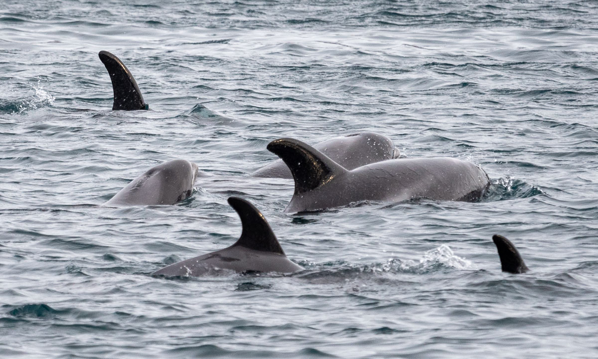


I do not know anything about dolphins. According to my colleague it’s White beaked dolphins.
Thanks a lot for the tipp, M. . It was a special experience to spot so many dolphins from land. Without your message I would have missed them.
Last Tuesday it got sunny and I paddled kayak. On Wednesday it got cold and the small sound between island Lillskär and mainland was covered with ice.

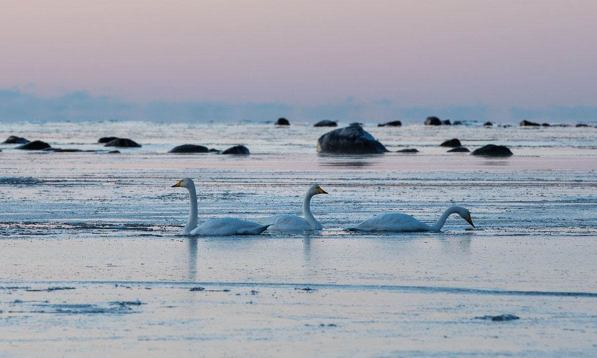
Although it’s mid-December and despite temperatures between -10 °C and -14 °C there were still whooper swans around. Don’t they migrate south? In the morning they managed to paddle through last night’s fresh and thin sea ice. In the afternoon the swans had left. Perhaps they finally decided to fly south.
On Thursday it snowed. In the afternoon 10 cm of fresh snow had fallen and everything was white and bright, even in the night.


On Friday Annika and I had a day off and visited friends in for a long weekend. They live in Kusfors in the inland, round 180 km north. On the way there and there we found more winter. It was not very cold but it snowed quite a lot. I took some images from the car while Annika was driving.


Yesterday on Sunday we came back to our house in Obbola round 20:00. Our property was covered with 45 of fresh snow. Since it had been sub-zero all the days the snow was pretty fluffy. We had to do quite a bit of snow shovelling – but after taking a photo.

Today it’s Monday and a new working week has begun. I had a lot of meetings today and therefore no time to paddle kayak. Oh yes, the kayaks … where are they? I know they lie beside the wooden terrace. Here they are, well hidden under a thick blanket of snow, right beside the window of the winter garden.

But there are other things to do as well. For example opening the afterwork ski season in Olles Spår near Umeå together with Annika. The snow is still soft and the cross-country skiing trail still slow but the first time of skiing is always special and we are happy and grateful that we live in a place where winter is around us.

Now it’s half past nine in the evening and I’m blogging. Snow is falling and the thermometer shows -9.5 °C, the same temperature as the last hours.
And you? What kind of winter do you like? Or do you prefer other seasons?
It’s weekend. Today I stopped working already at 14:15. Sunset was 40 minutes ago and the light is beautiful while I’m walking home.


In Tromsø there’s hardly any snow, but a lot of rime. In the evening there’s polar light, but I only take a smartphone snapshot – tomorrow is a long day.

Today is travel day. Round 16–17 hours it will take me from home to home.
Yes, I have two homes. One “work home” in Tromsø where I work and one “Home home” in Obbola where my wife Annika and I have a house by the Baltic Sea.
The weather is gorgeous and I take many photos through the window of the bus. Therefore some of the motives are blurred. The last one – the large bridge Hålogalandsbron is jittery because it has become dusky.


It’s a long ride from Narvik to Umeå. Departure 15:10, arrival 1:40 in the night. But it is a though train. I don’t have anything more to do but being awake on the arrival in Umeå. While I eat my take-away sushi outside of the train station it gets dark and so there is not much to see from the landscape in the train unless it stops.


In the frosty inland where it is quite cold I witness a special phenomenon. The whole forest we are passing is lit in green light. Another aurora? No, it’s cloudy. There are passages where the power lines for the train are coated with rime ice. The layer is so thick, that the current collector of the train looses contact and the electricity jumps over emitting bright green light that illuminates the dark forest.

The train arrives in Umeå in time and Annika already waits at the station. Another half an hour and I’m home home. Bed is waiting!
Oh, what a blessing it is to be home home. Normally we are supposed to work at the offices of the Norwegian Polar Institute but my boss knows about our long-distance relationship (or is it called long-distance marriage?) and allowed me to do home office until Christmas. Tusen takk! And it is even wintry and a bit sunny and a bit snowy.
From now on I can enjoy the view from my home office.


Enjoying the view from my home office is a pleasure but when all of the sudden the morning sun peeks through the clouds I just have to go outside and make some photos!


And what do I do at lunchtime? This:

This article is part of the series “2022-10: Autumn in Scotland”.
You cannot deny, that Scotland can be a pretty wet land. There are however different kinds of wetnesses.
This kind of wetness I love: bathing in the sea. Finally Annika and I managed to find a sandy beach that looked very promising for taking a bath. And it was perfect. No stones, no currents, no sharp-edged shells, no waves as high as a house. The water was warmer than expected and it hardly rained.


We continued our road trip through the region of Assynt and parked our car by the Stoer Lighthouse. From there we took a circular hike to the Old Man of Stoer, a 60 metre high sea stack. It rained and the trail was soaking wet and partially quite muddy. I managed to keep my rubber boots dry but Annika’s hiking boots were soaking wet after our hike. Her dancing experience helped her to change to dry shoes.


As the days before it was Annika that drove the rental cars. You don’t want to fall asleep while driving in Scotland. Beside the single file tracks with its many meeting points sometimes the roads are blocked by sheep. The road sign warning of a 25% steep hill however looked much more dramatic than the road was.


We have passed Ardvreck Castle several times the last days. Now it was time to stop and have a look.


The lake Loch Assynt was flooded and so was the path to the castle. I like hiking in rubber boots which is a bit overdressed sometimes. In Scotland however I think it’s perfect footwear. Here they helped me to wade to the castle to take some more photos, while Annika waited ashore.

I almost forgot to tell: At the beach of Clashnessie I observed sea monsters! Carefully I sneaked up to one of them and I managed to take a photo as a proof. There are sea monsters in Scotland!
10 cm high sea monsters.
10 cm high sea monsters buried in the sand.
10 cm high sea monsters buried in the sand looking suspiciously like seaweed.
