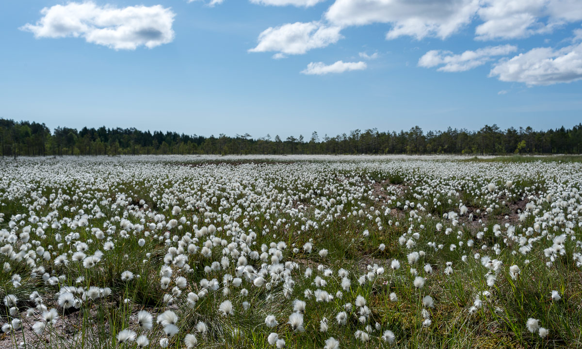
Cottongrass in full bloom
What a contrast to the first kayak tour six weeks ago: Last time dry suit, today t-shirt. Last time between ice floes, today birches with fresh leaves. Last time Baltic Sea, today the river Skellefteälven.
I put my kayak onto the new two-wheeled dolly (the old one broke down) and dragged it to the small bay Killingörviken, where I started my today’s tour. First I paddled along the harbour, then I turned right into the channel Kejsar Ludvigs Kanal. It always reminds me a bit of the “Ruhrgebiet” in Western Germany, where I lived for eleven years. After the last tunnel waited the Sörfjärden.


There I left harbour and industry behind and considered, where to go. The tour into the Nördfjärden wan, since it was windier than expected and I didn’t want to cross the Sörfjärden. So I paddeled upstream.


After a while the peninsula Örviken to my left ended. That’s where the Nördfjärden starts. I knew the first part and paddled to one of the rotten wooden piers. Luckily I realised that there were also under water parts – there were almost everywhere. I slowed down to avoid a collision with one of the big rusty underwater-nails. Finally I came to one of the four old platforms that probably formed an old pier, too – many, many years ago.


Now it was not far to the small island Gustavsgrönnan, where I made a short break. The whole shore is wet and covered with reeds, that lay flat on the ground.


I continued my tour by surrounding the island and paddled to the islands Stensgrönnan and Björnsholmen. To these islands you can drive by car and I was curious, if there would be a bridge or a tunnel to allow me continuing my trip.
First try Stensgrönnan: No chance! A solid dam connects the island to the main land.
Second try Björnsholmen: A small chance … . This island is connected to Stensgrönnan by bridge, but it looked really low. I didn’t believe I could manage to squeeze me underneath it until the end, but it worked. I had to bend my upper body onto the kayak and drag myself forward slowly by hand.


(Reminder to myself: This tour works only when water level is ±0. 20 cm more water and I wouldn’t fit under the bridge. 20 cm less and paddling could be hard due to the shallow water round the islands.)
Now I paddled downstream, which was not as much help as expected since the wind increased and came right from the front. But soon the bridge of the Sundgrundsleden was in view, the tiny cabins ashore and the dry dock with the read ship that I already saw on the way there.


I was a bit exhausted when I turned left to enter the bay Kurjoviken on the other side of Kallholmen. Now I was almost home, I just have to take the tiny tunnel “Lappstrupen” and I’m …
… well, that didn’t work. Due to roadworks this tunnel was completely blocked. Can I traverse the tunnel anyway? No. Do I want to walk and get the jetty? Neither. So I returned to the open water again and had another two kilometres against the wind until I entered the Kejsar Ludvigs Kanal again.


Now I headed back to my starting point. Another kilometer to go and I was onshore again. Phew – the last part was exhausting!


Today’s tour: Round 19 km total. (3.2 km extra because of the blocked tunnel Lappstrupen.)
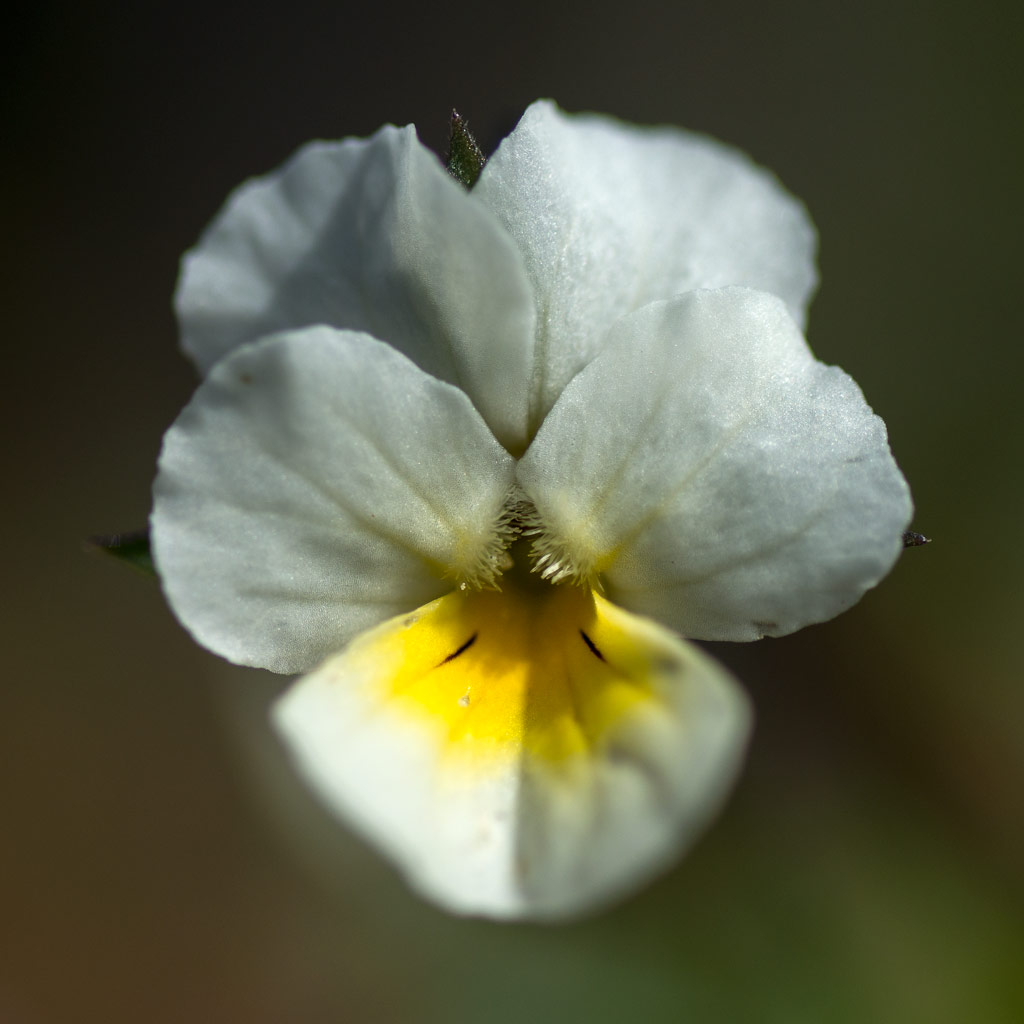
You didn’t like the water insects and tadpoles? Well, I found flowers, too, today. Finally the marsh-marigold has started to bloom. It is one of my favourite flowers and I love these warm yellow hues of the blossoms.

In contrast to the weather forecast yesterdays morning was sunny and sky was blue. I’ve been in Umeå the weekend and after the breakfast Annika and I decided to make just a small trip before weather would get worse.
We drove to Baggböle, 8 km west from Umeå. Here’s the “Arboretum Norr”, a tree collection (or arboretum) along the river Umeälven. We enjoyed the springlike temperatures and the many small flowers that started to blossom everywhere.


It was a bit too early for an extensive visit, since many trees just started to get their leaves, but we had another destination anyway.
In an abandoned turbine sump you can find an orange figure sitting cross-legged just as a statue of a meditating monk. The figure is reflected in the shallow water. This artwork is part of the Konstvägen sju älvar, a 350 km long tourist and sculpture route in Västerbotten. Sju älvar (seven rivers) sounds almost like sju elva (seven eleven), that’s how this artwork got its name: 8 11. Outside it was warm and sunny, inside it was dark and chilly. The ground was still frozen.

Probably the weather missed the forecast, because outside it continued being warm and sunny. So we continued our car trip, first toVännäs to visit another artwork: Eldsoffa (fire sofa) – a brick sofa that you can heat by fire (no picture).
After that we took a detour via Pengsjö and headed to another artwork between Vännäs and Bjurholm: Hägring (mirage).
A model of a church built of pieces of mirror glass seems to hover above a bog. It reflects it’s surroundings and if you go there over the wet boggy ground it reflects you yourself.

If you want to go to that artwork: Take rubber boots with you or you’ll get wet feet, at least in May.
After going round that artwork we continued our tour, had a brief look to Bjurholm and after that we started to return to Umeå again. We took the 353 southwards and would have been in Umeå one hour later if not my curiosity made me turn right into the road to Ågnasbacken, a local ski area. I love standing on hill and mountain tops and enjoy the views, but we discovered something better: The klangvägen (the sound path), a 1.5 km long path on two of the ski slopes with sound objects. Especially Sofie Weibull’s Klockspel – a wind driven installation of metal pieces sounding like bells – fascinated us very much. I did not make any photos because in my opinion it was sound that mattered, not the optical appearance of the installations themselves.
Anyway, I made a photo from one of the ski slopes and the view. And some leftover snow …

We came back to Annika’s flat eight our nine hours after start. Sometimes a short trip can get out of hand a bit …
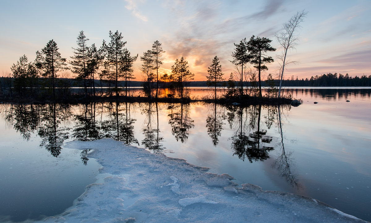
The heavy snowfall some days ago is history. Heavy rain melted the snow away. More and more ice on the lakes and the Baltic Sea disappears, too and only rests of snow and ice remind of the last winter.
Two images of the lake Snesviken – the first one shot yesterday, the second one made some hours ago.


(Shot on our wet hiking tour today.)
Start at 10:00 – up through birch forests – against the sun – looking through sun glasses at the multicoloured clouds – gaining height – over the treeline – less and less snow and more and more stones and rocks – fantastic views over the lake Torneträsk and the Swedish and Norwegian mountains – too rocky (and too late) to continue – skiing down – birch trees again, first some solitary, then denser and denser woods – back at 17:15 – too lazy to write more …


This article is part of the series “2016-02: Ski tour on the Kungsleden”.
27 February · 13 km · Link to map
This day I continued to the Alesjaurestugorna, the last mountain hut in the kalfjäll – the treeless mountain landscape in Lapland. Perhaps that’s why I was a bit sad, because I love the bare mountains and I felt that I had to say farewell to this outstanding landscape soon. I said farewell to quietness a bit, too, since I knew, that Alesjaure would be quite crowded:
But first of all I had a nice trip of thirteen kilometres to go. Weather was good and the way was short and easy, even if there were some patches with hardly any snow that I had to bypass. So I arrived in Alesjaure already at a quarter past one, being the first guest.


Other guests came, from Austria, from Germany, from France and from Denmark – many interesting people. And in between five scooters arrived – all with a trailer loaded with figures dressed in huge black down parkas and ski goggles – the Englishwomen. Their plan was to go back to Abisko on skis in two days with some detours to make it a full marathon distance.


The rest of the day was relaxed and easy-going. First I sat the sauna, then I made dinner (an outdoor meal called “Rice with basil” – quite boring). After that I sat together with all those kind and interesting people. At half past nine one of the Danes started to make pancakes – and I was invited! The Danes told me, that each of them has a surprise for the others on their tour and the pancakes were the first surprise. What a great idea (especially, since I benefitted from this surprise). I went to bed at half past ten – much later than the last days.
28 February · 20 km · Link to map
The next day I wanted to continue to Abiskojaure, that’s the longest part of my journey. The last tour days had quite short distances between 12 and 14 km and I was rather slow. As a photographer I have a good excuse: It’s making photos, that takes time, not my slow speed! Anyway, today I planned to start very early and decided to go a bit faster to avoid arriving in darkness. But first I had to get water, there was hardly any left.
If you tent in the winter, you’ll have to melt snow in most cases – this takes a lot of time and doesn’t taste well. The mountain huts on Kungsleden have ice holes to get fresh water, either in lakes or rivers. The ice hole of Alesjaure lies exactly below the summer bridge. It is covered with a wooden look to reduce freezing over, but I had to break the fresh ice anyway. It’s almost impossible to fill a 25 litre container with water (lowering the bucket into the small hole – pull it up again – pour water through the funnel – de-ice the funnel – pour water through it again) without getting wet hands. Oh, what I longed for waterproof gloves. My fleece gloves were completely soaked and my fingers got so cold that they itched when I “defrosted” them above the gas oven.

That’s why I started a bit later than planned and at the same time as the marathon skiers. They followed the official winter way, I took the short cut over the frozen lake Alisjávri. Although I took pictures I was faster than the skiers – some of them probably stood on skis the first time – and when I left the lake to join the winter way they already lagged behind.


I tried to go a bit faster, but stopped for some photos:


After I went more than half the way I took a break. It’s quite warm: -5 °C and even the cloud-covered sun warms a bit. For me it was a bit like saying good-bye. Good-bye to the treeless kalfjäll. Soon I will enter the narrow valley Gárddenvággi where terrain declines. And soon after I finished my break and continued the tour I saw the first small birch woods. The sun has disappeared behind a cloud layer and the landscape got monochrome. Dark birches, white snow, only interrupted by some red waymarks.

The last descend to the woodlands is quite steep. I decided to unmount my skis and go on foot. Even so the pulka tried to push me down towards the valley and I had to lean back to avoid being knocked over. After some minutes I was almost level with the Abiskojaurestugorna and went the rest of the tour through denser birch forests on skis again. I have to admit that I found this part a bit boring – we have snow and trees in Skelleftehamn, too, but soon I arrived at the mountain huts, where I spent the rest of the day.
In the evening I met C. who wanted to go to Abisko the next day and we planned to do this last part together.
29 February · 15 km · Link to map
Let’s make it short: This day was travel day. C. and I woke up at 6 o’clock. Not by our own will but because we had the loudest snorer ever in our room. Jet engine level! We took a short breakfast, packed our pulkas and started our tour. Not to Abisko Turiststation, the classical start and end of the Kungsleden, but to Abisko Östra, the station of the village Abisko. I went on skis, C. just with normal boots, since the snow on the snow mobile tracks was packed and easy to walk on. C. was much faster than I use to be, but we headed for the 12-o’clock-train and I was keen to get it, too. We took two breaks: One for elevenses (or some kind of pre-lunch), one for the reindeer posing in front of the kåta.

We mad it, we even had an hour time until the train arrived. 14 km in 3 hours, 8 minutes (including the two breaks) – that was the fastest part of my tour. Thank you, C. for helping me leaving my comfort zone a bit.

The rest of the tour: Train from Abisko Östra to Luleå. Bus from Luleå to Skellefteå. Bus from Skellefteå to Skelleftehamn. I was home at 21:30 – 13½ hours after starting on skis in Abiskojaure.
Now it’s midnight. I’m sitting in the living room of my house in Skelleftehamn. I really like this place, but I’m already longing to the Swedish Mountains again. Perhaps another ski tour later in April?
Well, we’ll see …
Yesterday I found the first blooming flower in Umeå – a tussilago, one of the heralds of spring in Sweden. On the other side I did something, that is quite typical for the winter season: I took a winter bath (and swam twenty meters).


Is it spring or winter? The Swedes have an own word for it: vårvinter – “spring-winter”. It’s the season round March and April, when snow still covers the ground – at least in Northern Sweden, but it’s less cold as in January or February.