Sunset kayaking

It’s a bit funny. Although the internet weather forecast rarely correspondents with reality, I check it anyway. Then I at least try to ignore it.
Last sunday, when Annika and I considered what to do, the forecast promised sun for two or three hours, but rain showers for the rest of the day. We decided to take the car to Norrbyn 40 km south from Umeå and the 11:30-ferry to the island Norrbyskär. If it really rained, I could at least try out my brand new rain jacket.
11:20 we were on board of the ferry Norrbyskär and soon the little ship put out to sea. The trip didn’t take long, it’s only 2 km to the island. I just love boat trips, it always feels like holidays when you stand on the ship’s bow, feel the airflow and look at the blue sea.


Norrbyskär consists of several islands connected with dams and as we experienced later even another possibility to cross the water. We went ashore with the other guests and headed left on the island Stuguskär. The way is framed by quite large brick houses. Most houses in Northern Sweden are made of wood and for us the brick houses looked more like a small coastal town in Germany, not a North Swedish island. The broad way ended soon, but a path continued through the forest and led us to a tiny bay. The single summer house standing on stilts brought us back to Sweden: it was wooden and painted red.


We continued to a place called Calmarn, another part of the island. The soil along the bay was brown and very bouncy. I had to look twice until I realised that the soil was neither sand nor mud. As many other places Norrbyskär had a huge sawmill in former times and this bay was completely covered with a thick layer of sawdust that gave you the feeling of crossing a huge trampoline when you walked on it.
We continued the path and entered the forest again. Soon we stood on the rocky north point of Calmarn, where we took the first rest. We sat down on a big rock, looked at the sea and enjoyed the blue sky and the warm sun. No rain in sight yet.


Now we went back the whole way until we almost were at the shipping pier again but continued the main road that connects the islands Stuguskär and Långgrundet. The street ends at a place surrounded by two white wooden houses and a bell tower. The entrance of the main building was labelled sommarkyrka – “summer church”. The ferries that connect the island with the mainland are going only between late april and early october – hardly more than 5 months, so probably this church is only active these months.


We went around the church where we found the Tannskärsstigen, a forest road on the peninsulas Tannskär and Truthållan. Sometimes the path was near the shore and you could see water lingering through the trees. Sometimes the path looked like leading through a huge and dense forest, even if Tannskär is hardly 500 meters in diameter.


It got warmer and warmer and we longed for a bath. The first beach was not actually crowded, but the nice places were occupied and so we continued our walk. The second bathing place wasn’t completely deserted neither, but big enough for us to find a place. A pair sitting on a wooden bench, some boats, some people on the pier, some kids in huge orange life jackets. We drank some water, ate some sweets and decided to take a bath.
Brr – the water was still really cold but so refreshing. So delightful! After the bath we laid down on the wooden pier and the sun dried us in a short time.


We continued the circular track and soon approached the summer church again. We went a bit back and crossed another dam to reach the island Stengrundet. Here’s a huge campground of the YMCA (in Swedish: KFUM). We had a look at the climbing crag where people with climbing harnesses and helmets climbed ladders and balanced on ropes, but soon we went to another shore were we had a look at the blue sea with its small and tiny islands.


We went back to the campsite, found another path through the forest and followed it, this time in direction north. The north peak of this island is extended by a quite long breakwater made of big rocks. Again a nice place to rest. In the east we could see the tiny island Burgrundet. It looked spooky. Some leafless dead trees and black birds. Crows? Dead man’s island? No, it weren’t crows, but cormorants sitting on the bare branches of the dead trees.


In the south we could see some wooden wrecks in the shallow water between Stengrundet and Långgrundet. On the satellite photos it looked like shipwrecks – almost like a ship graveyard. We went back – first along the shore then through the forest. It took a while but finally we found the path to the shore where we could see the wrecks of some twenty meter long wooden shipwrecks – an amazing view!
I already started to check the time because we wanted to reach the 18:15-ferry. The museum, which is not far away from ferry dock, was already in view and hardly hundred meters away, but on the other island. To reach the museum by foot we would have to go two kilometers to use the dam between the islands. But there happened to be an alternative:
When we looked at the shipwrecks we found a big wooden raft, tied to some cords that were fixed to the shore of both islands. Apparently it was possible to enter the raft and just pull oneself cross the water. After some considerations whether it would be (a) possible and (b) permitted we entered the raft, took the soaking wet cords and pulled ourselves over the water. It didn’t take long and we were able to hop on shore. We went into the museum, bought lemonade, strolled back to the ferry dock, sat in the warm sun (still no rain cloud in view) and waited for the ferry. A short boat trip to the mainland ended a wonderful day on the island(s) Norrbyskär.


This felt like an ideal day trip and – even though Annika and I both live in Sweden – a bit like Sweden in a nutshell: ferry trips and tiny islands, sailing boats and motor boats, a museum, a restaurant and a kiosk, stony and sandy beaches, huge rocks and forest paths, not to mention many flowers, ice cream and the first blueberries (still very sour!).
Conclusion: fully recommendable!
Official Site: visitnorrbyskar.se
Summer solstice– the longest day – the shortest night, that’s today.
I was out at the coast to take a photo at 0:37 – in the darkest minute of the brightest night 2016. The sun is hardly 2° below the horizon and so it looks more like an evening sunset or an early morning sunrise than a real “dead of night” shot.

The summer solstice marks the beginning of the astronomical summer, but it’s also the day, where nights will get longer and longer. And one day in August it will be dark enough for the first star shining through the pale nightly sky.
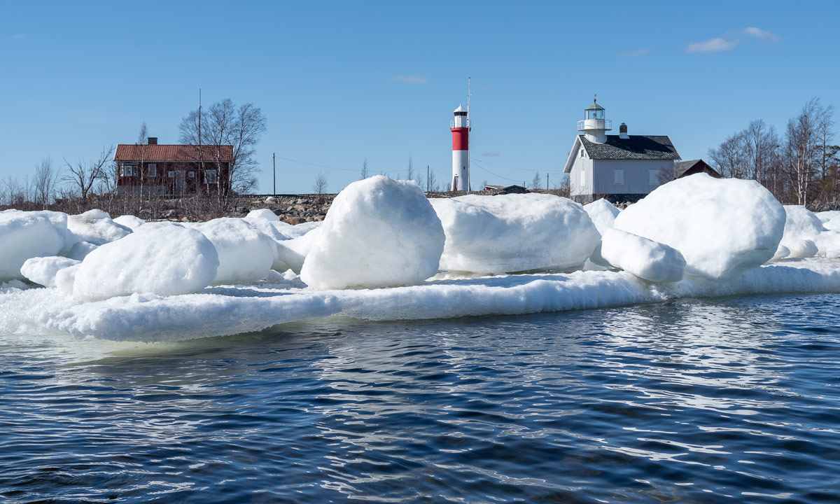
Skellefteå municipality has round about 400 kilometers coast line (depending on how you measure). Most of the coast is stony or rocky, but there are exceptions. Annika and I used the fine weather yesterday to drive to the peninsula Bjuröklubb, however not directly headed to the lighthouse and the café, but turned right to Storsanden and parked the car. After crossing a sandy grassland that already reminded a bit of the dune landscape of the coastal line of the Northern Sea, we hit a wonderful small bay with a sandy beach.


Round two kilometer to the east, there’s a complete different type of landscape: A long moraine headland, that reaches into the sea called Grundskatan. Normally it’s not easy to reach the peak without getting wet, but yesterday the water level was quite low and we easily reached the peak.


We returned the same way back to the car, drove to the parking place of Bjuröklubb and took the short way to the Café, where we had a late lunch. We went tothe lighthouse, where you have a great view over the Baltic Sea and the coastal scenery. A dark patch on the other side of the bay Gärdviken caught our eyes. Is it solid rock or a a field of big rocky pebbles? Let’s explore …
We took the car and found the way to the coast below the hill Petberget. The way was hardly drivable for my Saab, it’s more a path for forestry machines and jeeps. But – again – what a beautiful place!

What a contrast to the first kayak tour six weeks ago: Last time dry suit, today t-shirt. Last time between ice floes, today birches with fresh leaves. Last time Baltic Sea, today the river Skellefteälven.
I put my kayak onto the new two-wheeled dolly (the old one broke down) and dragged it to the small bay Killingörviken, where I started my today’s tour. First I paddled along the harbour, then I turned right into the channel Kejsar Ludvigs Kanal. It always reminds me a bit of the “Ruhrgebiet” in Western Germany, where I lived for eleven years. After the last tunnel waited the Sörfjärden.


There I left harbour and industry behind and considered, where to go. The tour into the Nördfjärden wan, since it was windier than expected and I didn’t want to cross the Sörfjärden. So I paddeled upstream.


After a while the peninsula Örviken to my left ended. That’s where the Nördfjärden starts. I knew the first part and paddled to one of the rotten wooden piers. Luckily I realised that there were also under water parts – there were almost everywhere. I slowed down to avoid a collision with one of the big rusty underwater-nails. Finally I came to one of the four old platforms that probably formed an old pier, too – many, many years ago.


Now it was not far to the small island Gustavsgrönnan, where I made a short break. The whole shore is wet and covered with reeds, that lay flat on the ground.


I continued my tour by surrounding the island and paddled to the islands Stensgrönnan and Björnsholmen. To these islands you can drive by car and I was curious, if there would be a bridge or a tunnel to allow me continuing my trip.
First try Stensgrönnan: No chance! A solid dam connects the island to the main land.
Second try Björnsholmen: A small chance … . This island is connected to Stensgrönnan by bridge, but it looked really low. I didn’t believe I could manage to squeeze me underneath it until the end, but it worked. I had to bend my upper body onto the kayak and drag myself forward slowly by hand.


(Reminder to myself: This tour works only when water level is ±0. 20 cm more water and I wouldn’t fit under the bridge. 20 cm less and paddling could be hard due to the shallow water round the islands.)
Now I paddled downstream, which was not as much help as expected since the wind increased and came right from the front. But soon the bridge of the Sundgrundsleden was in view, the tiny cabins ashore and the dry dock with the read ship that I already saw on the way there.


I was a bit exhausted when I turned left to enter the bay Kurjoviken on the other side of Kallholmen. Now I was almost home, I just have to take the tiny tunnel “Lappstrupen” and I’m …
… well, that didn’t work. Due to roadworks this tunnel was completely blocked. Can I traverse the tunnel anyway? No. Do I want to walk and get the jetty? Neither. So I returned to the open water again and had another two kilometres against the wind until I entered the Kejsar Ludvigs Kanal again.


Now I headed back to my starting point. Another kilometer to go and I was onshore again. Phew – the last part was exhausting!


Today’s tour: Round 19 km total. (3.2 km extra because of the blocked tunnel Lappstrupen.)
Today Annika and I took the road E4 to Byske to visit Byske Havsbad, one of the largest sandy beaches nearby. But I was curious about the other side of the river Byskeälven and took another departure. That’s how we came to Furuögrund, which is a small coastal village north from Skelleftehamn. 39 kilometres by car; 20 kilometres if you can fly. Outside of Furuögrund there’s a peninsula with a small boat harbour and a café (that unfortunately won’t open before next weekend). The peninsula is surrounded by two bays – one with a sandy beach (and still some old leftover ice).
On the northeastern side there’s an old dock for timber, build in 1874 together with the sawmill. The dock has or had three different names: Massahusdockan, Norrdockan or “Nööl-dockan”. As you can see on the images, there’s hardly anything left beside of a mikado-like stack of old timber.


After strolling along the shore we took the car again and turned into a small side road to Svartnäsudden. I just had to stop when I saw the smooth granit rocks with the clear water puddle. In front of the rocks there was some boggy ground, partly covered with ice, surrounded by pine trees. And behind that a beautiful view over the blue Baltic Sea – that’s Coastal Northern Sweden in spring in a pocket.

Yesterday smhi – the “Swedish Meteorological and Hydrological Institute” – issued a snow warning level 1 for Northern Sweden’s coast. Yesterday evening it changed the warning to level 2: 5-10, locally 15-20 cm of snow in a short time.
Well, Skelleftehamn didn’t get that much snow this time, only 5 – 10 cm, but it snowed crazy between 11 and 16 o’clock. That’s what it looked like directly at the seaside:

In Skelleftehamn it was a bit less windy but still a lot of very wet snow poured down. It wasn’t easy to take pictures, because not only the outside of my clothes, but also my cameras and lenses were soaking wet almost instantly.

Now it’s + 1°C and the snow starts to melt. But still my backyard, that was free of snow this morning shows just a plain white surface of snow.
It’s mid-April and the civil twilight already starts round 4 o’clock. A quite stupid time to wake up, but it happened to me today. Normally I would roll over in my bed and continue sleeping, but the sky was so incredibly clear, that I just had to stand up and take the car to the coast.
As clear the sky was, as cold was the air: -8 °C. Time for gloves and down parka again. East from the peninsula Näsgrundet the Baltic Sea was still open – just as on Monday, when I opened the kayak season.

West from Näsgrundet however, the frost has frozen together the drifting ice floes and put a thin layer of fresh sea ice on the bay Kallholmsfjärden.


Now I have to get some more sleep, it’s still quite early.
Finally the Baltic Sea round the peninsula Näsgrundet has been open and free of ice. Time to open the kayak season!
To Näsgrundet it’s just a 2.8 km walk from home. The kayak is tied onto a small two-wheeled dolly. I wear the same waistbelt, that I use for my pulka. Hereby I can walk and drag the kayak behind me without using my arms.

Soon I reached the peninsula and dragged the kayak onto the surrounding ice shield. After putting on my dry suit, lifejacket, neoprene boots, gloves and balaclava I was dressed for the first paddling. Perhaps I looked a bit overdressed, but despite of the springlike air temperatures it’s still winter paddling – the water is as cold as it can be.
I paddled along the ice shelf, that still connects the islands Bredskär, Klubben and Flottgrundet with the main land. The ice is soft and starts to get transparent, but it’s still quite thick.


Soon I reached Klubben and paddled along the icy coast.

From Klubben it’s just 200 metres to Flottgrundet and from that it’s only 500 or 600 meters to Gåsören …


… at least, if you take the direct way. I preferred a detour to paddle between the ice floes. It’s a great experience. Some ice floes are quite big and welcome resting spots for ducks, geese and seagulls. Others are so tiny, that they are hardly visible, especially if they are completely transparent and clear. They sparkle and glitter like huge diamonds.

After some detours I headed to Gåsören, circuited it to look for a good anchorage and went on land (or better said, on ice) to make a small rest.

After I stilled my hunger and thirst I entered my kayak again and returned to the Näsgrundet, this time on the direct way, which is round about two kilometres. When I got out from my kayak and stepped onto the ice that surrounds the peninsula, I heard a noise: A snow mobile crossed the same ice shield I paddled along some hours ago – in same distance to the open water. Spring, meet winter!

After taking of the lifejacket and dry suit I went home, dragging the kayak behind again and enjoying the springlike temperatures. No warm jacket anymore, no woollen cap – no gloves and no warm boots. Round 40 °C warmer than 12 weeks ago – glorious!
Most of the Baltic Sea at Umeå’s latitudes is free of ice, only some shallow parts and sheltered bays are still covered with an old yet thick layer of ice.
At Strömbäck-Kont – a nature reserve 20 km south from Umeå – the Baltic Sea was open, too, but ice floes still floated near the shore at Flakaskär and the small boat harbour Simphamn.

