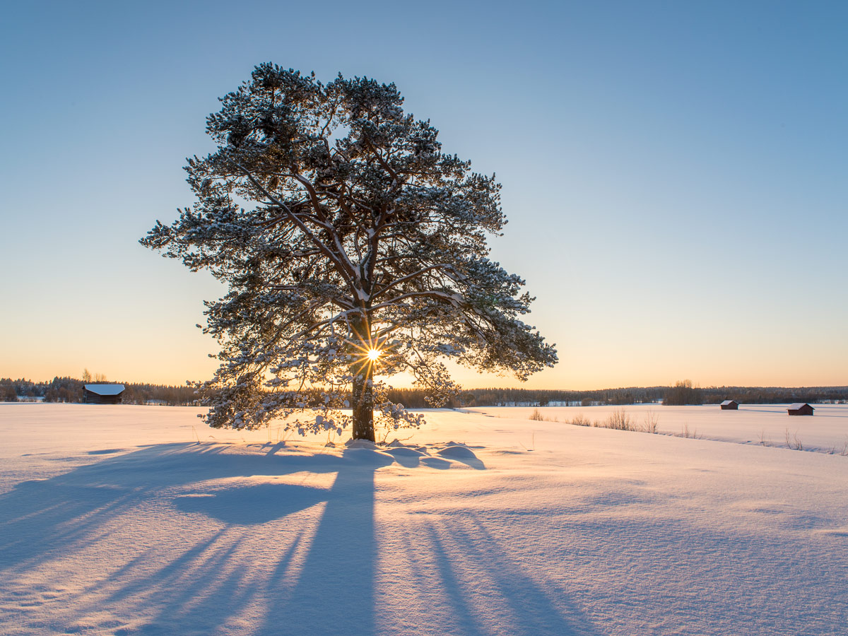
Another frosty morning

-5.6 °C showed the thermometer when I woke up at 6:15. I don’t need to look through the window to know that it’ll be a nice morning with mostly blue sky when it’s so cold in early October. And so it was.

The photo above is taken almost at the same place as the 1st photo three days ago. I prefer the older motive but like the intense colour of the sunlit clouds in the background. To other shots:

Have a look at the second photo, the one with the grass in the foreground. Why isn’t the horizon straight? That’s because I stood knee deep in the water myself, breaking the ice. When this happens, water from the hole will start to cover the ice. I just could take my camera, look through the finder and – click! – take a picture. One second later parts of the ice were covered by a thin layer of water.

That was the main problem: There is no save ground round these swamp ponds, where you could take your time for making pictures or even use a tripod. No, you stand knee deep in water on unstable ground, knowing that another step could bring you in much deeper water. I’m always afraid I could fall into the water and drown my expensive camera. It will me much easier when the ice is thick enough to stand on.

After a while the sun started to rise. Time for some more experimental images:

I realised the frozen bug on the second photo first, when I looked through the images at home. It’s hardly 2 mm big but looks quite huge on this macro photo. Learning: look at the motive even more precisely.

Some kind of autumn

Yesterday I dreamed of the first frost. The window panes of my winter garden where covered with frost patterns and even the floor was covered with frost. The door handle looked like bluish solid ice and I wanted to make a photo. Then I woke up.

No, winter is long away and even autumn hasn’t come fully yet. It’s still quite warm and autumn colouring has only started. Many birch trees are still green – weeks later than normal.

This is one of the reasons – beside of being very busy in the last weeks – why I hardly made any photos in the last time. But I made at least one picture that I want to share with you. That’s perhaps as much autumn as I could get this weekend round Skellefteå.

From Nallo to Vistas, Alesjaure, Abiskojaure and back to civilization

This article is part of the series “2015-08: Kungsleden hike”.

August 30 – September 2: Day eight to eleven of the summer hike through the mountains of Swedish Lapland

Nallo – Vistas

After two days in Nallo Annika and I were eager and keen to move on. After our breakfast we said goodbye to stugvärd Janne and started to ford the stream behind of the hut. Fortunately the water level dropped to normal again and quite easily we could cross the stream.

Then we went along the Nallú, a fantastic mountain that changed its appearance every other second because of the moving clouds and the changing light situations. We never tired of looking at this big mountain that seemed to accompany us a long way.

After a while another stream that we had to cross, came down from the lake Nállujávrrit. While I managed to splash through with my high rubber boots, Annika decided to take of her shoes and wade through it in her sandals – brr, the water was really ice cold!

We continued the hike through the fast-changing scenery. Quite soon we saw the first trees and realised that the big mountain ahead was the Vássačorru, that lies behind the valley Visttasvággi, where our next destination, the Vistasstuga is located.

Soon we crossed the Visttasjohka on the chain bridge and arrived at the cabin to meet the stugvärd – the warden.

Oh look: Coke and beer are priced down! That’s because the season only lasts three other weeks. After that the huts are closed down until their reopening for the skiers in February or March. But because none of the cans would survive the frost, all liquids has to be drunk in the next three weeks or poured away. We decided to save some cokes from this cruel destiny.

We were placed in the outhouse – the main building was in the act of being renovated. There we sat on the front stairs, ate, drank and looked on the river Visttasjohka. And we took a bath in this cold river. Chilling but refreshing! Finally the sun came out. I crossed the bridge to make a photo of our cabin.

Later – it started getting dark – we got a visitor: A big moose stood beside the river. I went out, where I could observe this huge animal, how it ate leaves and grass, less than 10 meters away. It looked at me but wasn’t disturbed by me at all, it even passed quite near until it vanished between some trees. This was one of the moments were I was glad and touched as a “normal person”, but a bit grumpy with myself, that I was too lazy to carry my big tele lens for better and sharper pictures. I never experienced a moose so near and so fearless.

Vistas – Alesjaure

The trip the day before was short: only 9 kilometres, this day it would be twice as much: 18 km. The first kilometres were a bit boring since they went through birch forests and quite muddy passages. But after a while the landscape opened and we could see the mountain Siehtagas with its glacier Siehtagasglaciären. In front of the mountain there were alpine meadows and small birch forests. In front of that the turquoise water of the Visttasjohka glimmered in the sunlight.

We went up again until we again were over the treeline. This part of the valley Visttasvaggi is beautiful and very varying. The first rest we made in the lee side of a huge cuboid rock. We weren’t the first – someone built a bench by laying a plank over two stones. The second rest we made at the Tjatjajaurekåtan (there’s not much left of it).

After a while I saw some reindeers grassing. There were shy and quickly went away when I came nearer. We saw (probably) them again when we had a view at the sami village Alisjávri that lies at the lake with the the same name. From that it’s not far to the mountain huts of Alesjaure – the Swedish version of Alisjávri. The Alesjaurestugorna are the biggest mountain huts of the STF – the Swedish tourist association. I prefer the smaller ones as e.g. Nallo, but it’s fine to have a shop, a drying room and especially a sauna. And we used it all! It’s nice to go to sleep after being in the sauna and having a wash in the river Aliseatnu.

Alesjaure – Abiskojaure

I didn’t make many pictures of this part of our tour. I was a bit bored of this part of the trail and found nothing special in the landscape. Just some photos of human evidence: Tent poles for a lavvu and a crossing over a long reindeer fence.

It was the first time, that I was really impatient and just wanted to arrive. Some kilometres before Abiskojaure we came below the treeline. Most of the birch trees still were green but you could see, that autumn is near. No wonder, it was the 1st of September, beginning of autumn for the meteorologists.

Finally we reached another chain bridge and shortly after it arrived in Abiskojaure. The sun came out and even though it was much colder than one week ago we could sit and lie on the short-cut lawn in front of the hut. I took the last bath of the journey and strolled around making some photos. After crossing a small swamp I came to a quite huge sandy beach beside the lake Ábeskojávri. A beautiful place!

The evening it started to become chilly, hardly 3 °C. I was curious if we would get the first frost of the season next morning …

Abiskojaure – Abisko Östra

… and yes, we got frost. -2.5 °C showed the scientific thermometer of the swedish weather service, when I had my first look. On the water surface of the buckets lay a layer of ice and round the leaves of lower plants I could see the first autumnal hoarfrost.

I was up very early that morning and I went to the beach at the lake again. First it looked quite normal but then it started to get foggy and misty while the sun rose behind the mountain Giron. What a beautiful sight! I stood there for at least an hour and only walked back to get another full battery for my camera. Later I met Annika, showed her the place and was glad that I could share this awesome experience.

I was a bit sad – this would be the last day of hiking through the wonderful mountain landscape of Swedish Lapland. But each journey has some kind of end and so had ours. We started our tour through the birth forests along the lake Ábeskojávri, than along the river Abiskojåkka.

After a while a famous landmark came into sight: Lapporten – “The Lapponian Gate”, a U-shaped valley framed of two mountains that give this valley its specific and recognizable shape. However, since this photo is taken from the backside, it hardly shows this special shape.

Since Alesjaure we followed the Kungsleden – the King’s Trail, but right after the bridge over the stream Nissonjohka we left the main trail that leads to the Abisko Mountain Station and turned right to Abisko Östra, the village, were we planned to stay for two other days. The way, however, was not much fun to go. A lot of all-terrain vehicles has turned the way into mud. Since I lost my lens cap and I was afraid that mud would splatter my lens, I packed the camera into its waterproof bag long before the worst mud patches. And that’s why this is the last photo of our hiking tour:

Thank you Annika, för trevligt sällskap – for nice company. Where should we hike next?

Any suggestions?

From Singi to Sälka and Nallo

This article is part of the series “2015-08: Kungsleden hike”.

August 26 – 29: Day four to seven of the summer hike through the mountains of Swedish Lapland

Singi – Sälka

After three very warm and sunny days clouds came in over night and the sky was quite overcast that morning. Only at the northern sky a larger patch of blue was visible. That fits, we’re going north! The first two kilometres were very well known to us, we went them there and back the day before. The day’s walk was short – just 12 kilometres.

Soon the huts of Sälka came into view. It was funny to see the ads for the shop and the bastu – the sauna – amidst the extend mountain landscape. Only 300 meters left and we entered the reception to check in.

It’s a nice look from Sälka but we had another interest that afternoon: Overall on the ground the ptarmigans were running and there were even sitting on the huge pile of birch wood, so that me, the photographer and them, the models, were on eye level. They let me advance quite near – in fact so near that the tele lens couldn’t focus anymore. The first two images are younger ptarmigans, the last is a grown up – look at these fantastic white feathered feet.

Sälka – Nallo

The next morning there were so many ptarmigans around that you really had to watch yourself not stepping on one of them. I never saw so many and never saw them so near. Our plan was not to continue the King’s Trail but to go northeast to Nallo, a smaller cabin a bit higher up in the mountains. After the common breakfast (muesli with some milkish liquid made from dry milk – yuck!) we started our tour. Even shorter than yesterday: only 9 km but perhaps a bit more demanding since there’re streams to ford, while the whole King’s trail is equipped with Bridges.

We had to look for planks to cross the small rivers behind the cabins but soon we were on our trail.

One hour later we were on the moon …

… well, not exactly, but it was such a sharp contrast to the sweet and lovely landscape of the last days. We could hardly see any vegetation. Only moss, grass and some scattered flowers were left. And some reindeers on some of the tabular slopes. There were many small streams and brooks to cross and it was the first day where I was glad, that I walked in rubber boots.

After a while the lake Reaiddájávri that lies on 1056 meter came into view and we went along it. More and more clouds came towards us and swirled around as if they wanted to surround us.

We had to cross the stream that enters the lake at the northern shore. Annika had to switch to sandals and ford the stream, for the water was to high for her hiking boots. It started to drizzle, than to rain and it got windy. Navigation was less easy now since it started to get foggy, there were less marks and some streams and snow patches to cross. Mostly I navigated with the compass, but twice I took the GPS to ensure my navigation. Since wind and rain increased more and more and I was busy with the navigation I packed the camera into the waterproof bag and didn’t make any photo on the last two kilometres. In the end the small Nallostuga came into view and even the huge mountain Nállu in the back lingered through the floating clouds. We got a warm welcome of the stugvärd – the warden of the Nallostuga. And warm was the wood fired oven, too. A good opportunity to dry our wet clothes.

I only went out later that day to take a photo of the wooden signpost and the hut itself. The rest of the day was just gemütlich – the pouring rain outside and we ourselves warm and cozy inside.

Two days of at Nallo

One

We planned to stay a day in Nallo already two days ago. It looked like a good idea since the rain just poured down the whole day and it was very windy. All people out there looked very wet, whether they just crossed the stream – now twice as large and probably twice as deep – or if they just fetched a bucket full of water.

Time to make some photos within the house. Two typical views in Swedish mountain huts: Many of them have two rooms, each has a kitchen and two flanking bedrooms, only separated by a curtain. That make 20 beds in total. Plus one for the stugvärd who has his own little room. The Primus 2388 is a gas cooker, easy to handle and is found in almost each Swedish mountain hut.

Two solo hikers planned to continue their tour that day but after a while they decided to stay. Perhaps not the worst idea when you looked at the young hikers, that came in. They were completely soaked. They poured the water out of their hiking shoes and hang up the dripping-wet sleeping bags for drying. All was just soaking wet! We we’re quite glad to be inside. But finally I took my camera and went out for some photos. Brr, it was really cold (7 °C) and so windy that the spray of the brooks was blown upwards again. Some photos:

I was glad, when I came into the inside of our cozy hut again. Only Simba, the warden’s dog endured the weather stoically.

Later that day: The sleeping bag already has dried, but other clothes were still hanging on the clothes line.

Two

Next day we wanted to continue our trip but I changed plans. Unintentionally. I got ill. I got fever that night and problems with my stomach and intestines, that I definitely don’t want to describe in detail. Otherwise there’s nothing much to report. I didn’t make a single photo (a certain proof that I was really ill) and slept almost the whole day.

Later in the evening, when I felt a bit better I was able to communicate again. I heard about others that went Singi–Sälka, the very same way we went three days before. The trail has been so flooded that the water poured over the wooden planks of the minor bridges making them very slippery and it was so windy that the hikers were really frightened to be blown from the bridge right into one of the swollen rivers. Illness never fits, bit I guess I chose a quite good day for being sick.

I slept the night before, I slept almost the whole day and I slept the next night. That sums up to round about 30 hours of sleep without any larger interruption. That probably was the best medicine and the next day I felt sound and healthy again. The plan for the coming day: Hiking to Vistas.

From Kebnekaise Fjällstation to Singi

This article is part of the series “2015-08: Kungsleden hike”.

August 24 and 25: Day two and three of the summer hike through the mountains of Swedish Lapland

Kebnekaise Fjällstation – Singi

After the crowded Kebnekaise Fjällstation I really longed to continue our hike. Soon after breakfast (with real German bread!) we left and continued westwards. Soon a first wooden bridge over a small creek came into view followed by a larger bridge over the ravine that the stream Láddjujohka has cut into the rock. In the back: The mighty mountain Siŋŋičohkka.

It was as warm as the day before and the sky was incredibly blue. We continued westwards and went round the steep southern slope of the Siŋŋičohkka. Parts of the narrow valley lay in the shadow of the mountains Skárttoaivi and Liddubákti, but soon we came to a sunny place covered with soft heather beside of a small creek – the ideal resting place. It was hard to prevent dozing off and to pull ourselves together to continue after a long while of resting and being lazy.

This daily stage was quite relaxed: only 14 kilometres. Soon the Singistugorna – The Singi cabins – came into view.

We hardly saw any animals yet but round the cabins we saw two quite typical species commonly found in Lapland: The lämmel or lemming and the ripa or ptarmigan (sometimes called snow chicken). They came quite near but gave me a hard time photoing them. I only had a small 100mm-lens with manual focus instead of my great but huge and heavy 70-200mm-lens, so I’m not really content with the results. However, the experience to have these animals so near was more important.

(Later on the journey I got a much better opportunity to take pictures of ptarmigans …)

Singi – Hukejaure – Singi

This day was planned to be a long one! Instead of following the Kungsleden – the King’s trail we planned to go to Hukejaure in the west and then to cross the Swedish-Norwegian border. From Singi to Hukejaure it’s 20 km and it’s just a path, only partly marked.

We started quite early, went north along the stream Tjäktjajåkka and crossed it after two kilometres on another chain bridge.

We had to “climb” over some rocky parts until we came to a beautiful alpine pasture. Do you know the film The Sound of Music? It almost looked alike – without the dancing and singing. Instead of that we got some snow fields and some shallow bogs and ponds. Beautiful anyway:

After a while the path was gone and we had to go up some hundred meters. It was as warm as the other days plus we were on a treeless southern slope – a matter that makes one sweat. We made a rest after 7 or 8 kilometres. It was later than expected and we just made the easy part of our way today. Will we come to Hukejaure in time? Or will it get dark? Is it safe and reasonable to continue? We both didn’t like the decision but since we weren’t sure to reach Hukejaure in time we decided to go back. Next time we have either to start even earlier or take a tent with us. We’ll see …

After 5 kilometres we came to the Tjäktjajåkka again but the light was completely different.

The last two kilometres felt a bit boring and we were glad when we arrived at the Singistugorna that we left the same morning. Other people walk there dogs, we walked our backpacks. After a two-course dinner (noodle soup and tortellini) I went around in the dusk and took pictures of the landscape reflecting in the oxbow lakes of the Tjäktjajåkka.

I was glad that I had my mosquito jacket with me, they were many of them seeking my blood that evening. And when I came back I was glad that all windows are equipped with fly screens to keep out those little bloodsucking vampires.

On the one hand it was a disappointment that we had to change plans, on the other side the tour itself through this side valley was awesome. We probably would never have thought about it without our Hukejaure-plans. Next stop tomorrow: Sälka, only 12 kilometres.

Cloudberries – the gold of Lapland

The very short version:

The longer version for those who don’t know these berries:

These berries are called cloudberries (German: Moltebeere, Swedish: hjortron, Norwegian: multe). Cloudberries like bogs and wetlands where they bloom and bear fruit in July and August. That’s exactly the heyday of the mosquitos, that like bogs and wetlands, too. The berries are found quite outspread and it takes some efforts to collect them. (Remember the wetlands? Remember the mosquitos?)

Cloudberries have a quite special taste. I love them but not all share this liking. They are very healthy and contain three times more vitamin C than oranges.

I went berrying yesterday and checked some bogs near Bygdeträsk, where I stayed the weekend with good friends. I wasn’t very lucky. I hoped I would find enough of them to freeze them for later use, but this small amount will not survive the next days. But I was lucky in another way: hardly any mosquitos.

But I found other things. A small deep pond in the middle of the first pond, a so-called bog pond. If you stand beside such a bog pond you should remember that you’re standing on water or mud, that silted up and became overgrown. Be careful, this ground can be very treacherous!

And I found another thing: A plant, that’s special because it’s flesh-eating: A sundew. What a pity that it didn’t bloom yet.

Sundew is quite common here and grows on wet patches and mud. This one, however, grew directly on water that was covered with just one millimetre of peat. I never saw this before.

By the way: I met a neighbour today, he went cloudberry picking as well. He was a bit disappointed because he picked only 4 kilos. I definitely have to check more bogs to find better places.


Translations:

EnglishGermanSwedish
cloudberriesMoltebeerehjortron
to silt upverlanden
sundewSonnentausileshår
peatTorftorv

For the longhorn beetle enthusiasts …

Both longhorn beetles found in Bygdeträsk. The Leptura quadrifasciata on Friday, the Lepturobosca virens today.

Translations:

EnglishGermanSwedish
Longhorn beetleBockkäferLånghorningar
Leptura quadrifasciataVierbindiger SchmalbockFyrbandad blombock
Lepturobosca virensDichtbehaarter HalsbockGrön blombock

Continuing to the Vesterålen

This article is part of the series “2015-07: Lofoten and Vesterålen”.

Our third day started with a lot of rain. We put the wet tent into the car and continued our tour to Kabelvåg where we visited a friend of mine. We took a small mountain hike but it was cloudy and wet. Only far away in the east you could see some sunny patches on the top of the snowy mountains.

After the hike Delle and I looked for a camp ground. But first I had to take a picture of the beautiful rainbow near Sildpollen.

This time we tented on a bigger campsite in Sandsletta. When I woke up quite early the next day I could see another rainbow over the Vatnfjorden, but later it started to rain and pour down again. And again we put the soaked tent into the car. We continued on the road 888 to Fiskebøl. The clouds were hanging low and you could hardly see any mountain, just some white and light grey schemes.

Soon we arrived in Fiskebøl where we waited for the ferry. Again we were lucky – we waited hardly half an hour until we entered the ferry for the short crossing to Melbu, the southernmost city of the Vesterålen. We visited friends of mine, this time in Haukenes were we tented near the friend’s house. The cocks tried to wake me up ridiculously early, but in vain. I continued sleeping until 8 o’clock.

Alas it was the first morning without rain (and the only one, too) and we could dry the tent. After a long and lazy breakfast with my friends we said farewell and continued our car trip. We got a tip to visit Stø at the northern end of the Vesterålen island Langøya. What a good tip and what a beautiful landscape – especially after the weather was nice and sunny. We made a short photo stop between Strengelvåg and Klo before we continued to Stø.

In Stø we parked our car and took a short hike over the mountains to a beautiful white sanded beach were we made a rest and I took a short bath. There’s a 15 km hiking trail as well; next time I’ll definitely will go it.

After our rest we slowly walked back and continued by car. First we had to head south to Sortland were we crossed the Sortlandsundet and headed north on the other side. The sky became more and more cloudy and we looked for a nice campground. Finally we found one in Bleik, quite near Andenes, a town at the northern end of the Vesterålen. We put up the tent and – guess what – it started to rain.

It had been raining the whole night and it continued raining. Again a soaking wet bunch of a tent lay in the back of the car. After a while of driving through the greyness we decided to head back to Skelleftehamn. It’s more than 900 kilometres and it took the whole day. Rain became less near Abisko and after we passed Jokkmokk the sky cleared up and we could see the full moon slowly rising. The next photo, which is the last of our car trip through the Lofoten and Vesterålen is taken near Storforsen, one of Europe’s biggest rapids. At 23:50 we were in Skelleftehamn again – and I was home.

  • 2296 kilometres in six days
  • a lot of clouds and rain, but two nice and sunny days, too
  • one night in the car, four in the tent (three of them on campgrounds)
  • two bathes and at least four rainbows
  • – a nice trip!


From Å to Rystad

This article is part of the series “2015-07: Lofoten and Vesterålen”.

Day 2

Next morning when we woke up in Å we could see blue sky through the fogged car windows. The rain has stopped. We made a walk through the little fishing village and had breakfast on the cliff with a fantastic view on the mountains and the sea.

After that we continued our trip through the incredible landscape of the Lofoten. We had to stop several times to take pictures, for example of this small mountain lake near the road to Nusfjord:

Later we came to a place that became quite famous over the years: Uttakleiv – a beautiful sandy beach that just invites you to jump into the turquoise-coloured water. It almost looks Caribbean but as soon as you enter the ice cold water you’re reminded of being in Northern Norway, not in the south. The bath was fun, anyway.

Here we stayed for a while and enjoyed the sun. But after a while we continued our road trip to Brenna on the island Austvågøy. We didn’t find a camping ground at the end of the road and turned, but soon we stopped the car again. Actually because I wanted to take pictures of the sheep that lay at the sandy beach, but some children nearby discovered something much more interesting: A fox cub. I changed to the telephoto lens and I came quite near. Probably the fox hadn’t made any bad experiences with humans yet.

After that we stopped at a camping ground near Rystad that we already saw on the way to Brenna and decided to stay overnight. Soon the tent was put up on the grassy ground. Slowly the sun went round the mountains and sank down. The next hours were incredible – the light was so wonderful, both the sunlit main land in the south and the sea in the north glowed in the most fantastic colours. But have a look by yourself:

Round one o’clock we lay down in our tent, but only because clouds came and it started to rain a bit. What a wonderful first day on the Lofoten!