Like ice in the springtime …

In the rare cases where the temperature rises above 0 °C something special happens: Ice and snow melt and become a liquid known as „water“. One of these rare occasions is called „spring“ and this is what has started happening right now. In these days many things happen that are related to ice, snow, and water.

8 April: Vattenplasket in Malå

Last Friday Annika and I visited our friends Lasse and Martine in Kusfors and stayed over. Lasse is a journalist and had a job in Malå the next day. There was a very special ski competition named “Vattenplasket” – the water splash. A ski hill and instead of a finish line a large basin with knee deep water. Is it possible to downhill on ski or snowboard and have enough momentum to cross the water? Let’s see:

Most of the competitors failed, two actually managed it. True sportsmanship showed a small boy that did not get enough momentum with his sled and just walked into the water. Kudos!

9 April: almost a kayak tour

On Sunday Annika and I tried to do another kayak tour. Five days ago the ice was stable, this day it had got holes and was not reliable anymore. While Annika stood on safe ice I tried to cross the old ice to the island but **splash!** broke through several times. No biggie, the water is quite shallow and we have drysuits but it is exhausting. When Annika started breaking through as well, we decided to return. Another time …

10 April: winter bath

Finally. Annika and I. Twice. And then: sitting on the rocks in the wet bathing clothes without freezing because the sun is so warm. Springtime!

12 April: ice work

This is a piece of ice seen from the side. You can see the different horizontal layers that accumulated over time.

This is however no glacier ice nor Arctic sea ice. It is a piece of ice from our way to our house. Annika and I have been chopping the ice bit by bit for many days and today was the day: the way to the car and the road is free of ice and snow.

12 April: another “almost” kayak tour

There are other parts that are free of ice: Most of the weak ice between land and the island Lillskär is gone. After work I tried to paddle around the islet. We had low water (-30 cm) and some of the stable ice was grounded while large parts of the sea were open.

The first part was easy but when I almost rounded the island I came into an ice field. I already had seen it before starting the tour and thought I could paddle through. In theory this was possible, but the wind and the layers of ice made it near to impossible to steer the kayak.

So I got off the boat, jumped into the 60 cm deep water and while standing turned the kayak back to course. Now I could continue my island circumnavigation. Anyhow I consider exiting the kayak on the tour cheating, that’s why I say: I almost circumnavigated Lillskär today.

Even though the ice floes may have been 7–8 cm thick you couldn’t stand on the ice any longer. The ice was “rotten”. Many tiny vertical channels had weakened the ice and made it sensible to vertical stress. You can see it on the next photo. The piece on ice is standing, the bottom part of the ice floe is on the left.

What a wonderful vårvinter kayak tour!

Yesterday the weather was calm and sunny. A perfect day for kayaking! Perhaps to Vitskärsudden, our favourite beach?

Chapter one – Bredskär

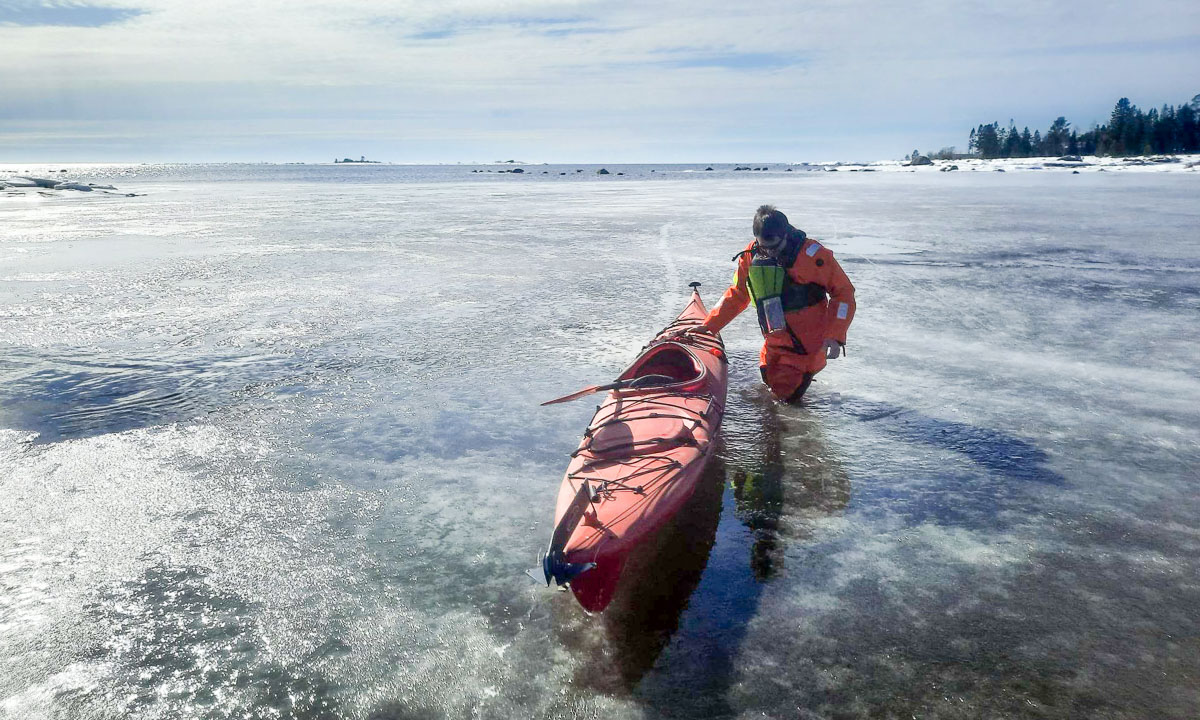
Kayaking needs a bit of preparation, especially in winter. After we have fixed a problem with Annika’s rudder, dressed ourself and went over the ice to the northern tip of the islet Lillskär we are ready to start our tour.

Annika goes first, I follow. We turn left and paddle along the edge of the ice.

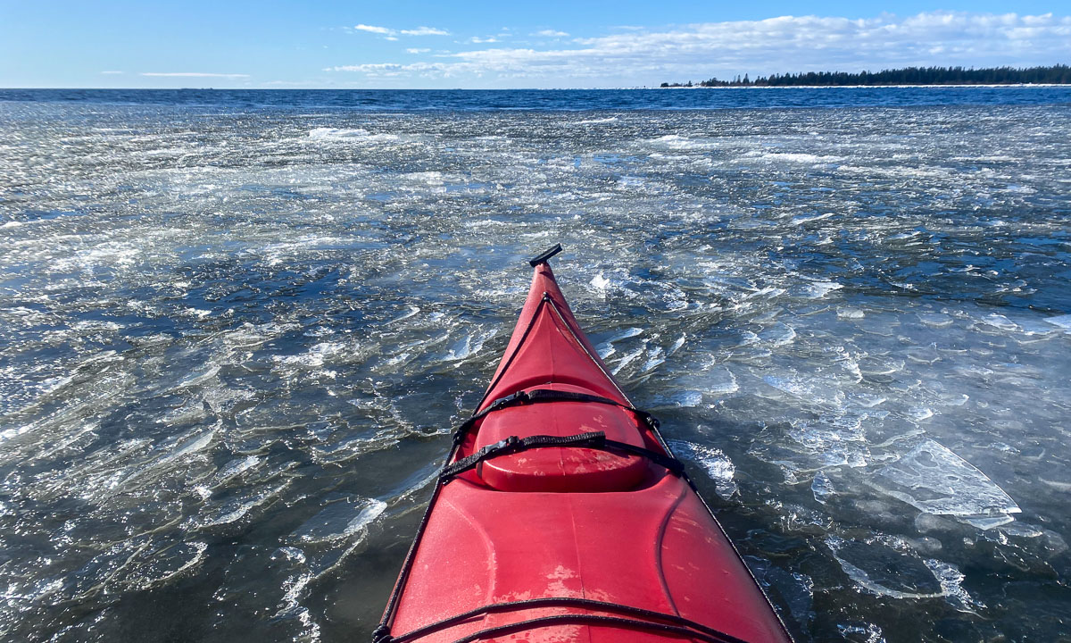
Sometimes we cross fields with crushed ice. Many of the ice slices are thin and in the waves they sound like tuned bells.

We paddle along the island Bredskär. The waves are shallow and there is hardly and wind. I have to make a short stop to take a picture of the “ice monster”, then I follow Annika to the sandy bay in the northeast of the island.

We continue following the coastal line until we come to Bredskärssund, the sound between Bredskär and Obbola. As expected the sound is covered with ice and we have to return.

Time for …

Chapter two – Vitskärsudden

Slowly we paddle back enjoying the exceptionally beautiful weather and the ease of movement. Leaving Bredskär behind we cross the water heading for the rock that marks the entry to Vitskärsudden.

Arriving there more ice fields wait for us. Here are many layers of thin ice and it is not easy to find gaps to put the paddle in. Often it just glides and slides away.

It is not possible to paddle into the bay. It is covered with ice floes, many of them thick and large. But we do not want return home – too beautiful the day – and decide to paddle to the islands Obbolstenarna where we shortly have been two days ago.

Chapter three – Obbolstenarna

The way there is easy. No mentionable wind, just open water. In front of the islands there is another ice field, but it is small and easy to cross.

The next ice field is thicker. We try to break through but decide to go round. We just follow the coastal line.

In the south we go round an ice cap. According to the nautical map there is no island, just a shallow with some rocks.

Again I take a small detour to take a photo. This time to a large ice block.

Then we paddle north. First along the islands …

… then …

Chapter four – Home

we are leaving Obbolstenarna behind and head home. We enjoy the effortlessness of our today’s kayaking but we got a bit hungry. 10–15 minutes later we stand on the ice near our house.

We take a tour selfie then we drag our kayaks back home. First over the ice, then through the snow.

Thanks for the fabulously beautiful tour, Annika!

Annika tracked the tour with her smart watch. Here’s a small map. I added some names.

Hiking up the Slåka and Guratinden

Slåka (314 m) and Guratinden (424 m) are two mountains on the island Kvaløya. I know them from my book “På tur i Tromsø” where they are described in tour 7. This tour is marked as green, which is the easiest category in this book. I chose it because on the higher mountains there still might be some amount of snow and I wanted to avoid that.

I took the car to the parking place in Skulsfjorden yesterday. The parking place I already knew from another tour. Then I tried to find the hiking trail while the cows starred at me curiously and the bravest of them came to sniff at my hand.

It took a while until I found the way which was not were the map showed it. It forked quite soon and maybe I followed the wrong direction because somewhere over the tree line it faded away somewhere in the heather. Way marks and sign posts you will hardly find when you hike like this in Norway. It is assumed that you can orientate in pathless terrain even on beginner tours. Anyhow a way to the top of the Slåka was easy to find without paths. Here I had a fantastic 360° view. In the north the mountain Nuortagáisi (or Nordtinden), in the south the fjord Kaldfjorden, in the west the island Vengsøya and behind that the open sea. And where there was no sea there were mountains, mountains, mountains, all higher ones still covered in snow.

Without any break I continued to the Guratinden. Again I could not find a reliable hiking trail but more a patchwork of paths, some of them probably animal tracks. Anyhow it’s not far to the Guratinden, where I took a rest to enjoy the view and something to drink.

Although it was the beginning of June it was very chilly on the summit, mostly because of the strong wind. I guess it was 7 °C and at least 15 m/s. Already on my way up I wore gloves and a woollen cap, now I was really glad about my down hoodie. Without I wouldn’t have taken any rest.

On the way back I followed other trails and tracks or I just cut cross country. Sometimes I walked on rocks, sometimes on boggy ground but mostly on heather.

Round three hours later I was at my car after 9 km hiking and round about 650 metres in altitude. And here you can see how it looks on the map when you hardly follow any trails ;-)


Thursday paddling round Grindøya

Yesterday I was in the mountains – today at 18:00 I joined the torsdagspadling (Thursday paddling) of the Tromsø Sea Kayakers Club. Together with 16 others paddlers and a dachshund we crossed the Grindøyskarven and rounded the island Grindøy.

The conditions were excellent: Hardly any wind, a calm sea, blue sky and temperatures almost 20 °C. Perfect not only for paddling but also for taking a break in the sun – of course at the northern tip where we didn’t disturb the common eiders that nest along the beaches of Grindøya. Then we paddled back – with a small sprint to avoid two ships crossing. No danger however because the guides have a VHF to talk to the ships but they already had spotted us and had slowed down. Three hours later we were back from our round 12 km long paddle tour.

Takk for turen, thanks for the tour! And thanks to all organisers of the torsdagspadling. Great initiative!

After work promenade to the Keiptuva

38.5 km by car, 5.5 km by foot. Some hundred metres in altitude. Warm and windy weather. Forests, slopes, shallow bogs, mountain paths, water to ford, flowers, snow fields, lakes, tundra, rocks, views to the mountains of Kvaløya, the fjord, the open sea and Greenland. OK, cross out the last point. Anyhow, quite much for a short after work promenade.

Mountains, sea and midnight sun

Yesterday at 18:00 I took the car to Elvenes on Kvaløya to start a small mountain tour. Well, mountain or hill – the summit of Grønnlibruna is only 401 metres above sea level. I chose this destination in the hope that it was not completely snowed over as the higher mountains still are.

I parked the car, walked the gravel path and stood before the first obstacle, the stream Finnelva. I did the same tour last November, where it was easy to cross. Now in the thawing period the water was at least 50 cm deep and quite fast . Too deep to cross here, even with rubber boots. Luckily I found a better place to ford a bit upstream. Soon I was in the forest. A very wet and muddy forest where I was not always sure whether I followed the way, crossed a swamp or waded in a brook. But this stopped when I gained a bit of altitude where old snow covered the forest floor.

As soon as was above the tree line the landscape changed again. There were some large snow fields but most of the ground was bare of snow and easy to walk on.

After 4 km of hike and some hundred metres in altitude I stood on the summit enjoying the circular view while the weather cleared up more and more.

I did not take a break but hiked down again. I enjoyed the weather and the fact that the birch trees start to turn green, at least in the lowlands. I crossed Finnelva a second time, now with a sturdy stick that I had found on my way. It’s much easier to keep balance with such a “third leg”. From there it was not far to my parked car that I reached round 21:30.

When I left the supermarket in Eidkjosen it was 22:00 and the sky was blue. It won’t get dark because the last sunset in Tromsø was more than a week ago. Since then we have polar days with 24 hours of daylight. I could drive home or …

I turned left. Left to the road 862 that leads to Sommarøya. Maybe I catch the midnight sun. Sometimes I had to drive slow because of the reindeers, sometimes I had to stop to take a photo …

… but round 23:00 I had crossed the bridge to the island Sommarøya and shortly after I parked at the sandy beach Steinsvika. I was not alone. People stood at the beaches, some lit a fire, some paddled kayak, some camped in the hills.

I checked an app when sun would be lowest. What? 0:45!? I forgot, that we had daylight saving time, so clocks were one hour ahead. I took my camera bag, some water and an old jacket, that I use to have in the car and walked to the northern tip of Kvalneset. Now I had a lot of time to just observe the sun hardly going down. After one and a half hour it was time: 0:45 – the sun was at its lowest position: 1.55°. The photo is completely unspectacular because it only shows a low sun, not the fact that the sun would not get lower than that this night.

I was glad about my jacket because it got a bit colder, I was tired and I sat there for almost two hours in total. At least I had chocolate! I waited for the sun to disappear behind the prominent silhouette of the island Håja.

Then I went back to the car and had about an hour drive back home. I wasn’t in bed before 3:30 but it was completely worth it. For a very good reason: I never ever saw the midnight sun in my life before! Although I have lived in Northern Scandinavia for more than 12 years I hardly was above the arctic circle in summer and then it was cloudy.

But it was more than just checking another item of my bucket list. It was just gorgeous to sit there and enjoy nature. I should do that more often and put the old sleeping bag back into my car. Just in case …

A sunny ski tour to Bønntuva

Three weeks ago I made a ski tour to mountain summit Bønntuva. There was a layer of half a metre of fresh snow and it snowed so much, that navigation was quite demanding.

This morning I decided to take a day off and do a ski tour to Bønntuva again, because finally the weather is sunny and warmer. No snowfall, no sleet, no stacked cloud layers, just a blue sky.

Same routine: Park the car, buy a ticket for Fjellheisen, the cable car and check, how much snow has melted away from the swing and the slide on the playground. Well, not much!

But you see the difference. Patches of heather and more rocks are visible. The cabin Steinbøhytta however is still snowed in, too.

The only other skier, that started with me – you see him on the first photo – is far ahead and so I have the mountains for myself.

Thanks to my short climbing skins that you can hook into the skis and the easy conditions I reach the the summit of Bønntuva earlier than expected. Time for a short rest and a photo with self-timer. (To the right the selfie from 19 days before ;-) )

The view is marvellous. It’s mountains everywhere. Some are rocky, some are snowy. Some are steep, some are rounded. Some are by the fjords, others amidst other mountains. So beautiful!

After the break I decide to ski back. I am pretty nervous because the snow is fast and I am a lousy downhill skier. Where other carve beautiful sinus waves into the snowy slopes I walk more zigzag. Anyhow I manage to ski down the Bønntuva (which is not steep at all). Now I start to meet other people. Some on skis, some with hiking boots, because the snow is quite compact. I use one track of a skier to bypass the summit of Fløya – a good track, that slowly leads downwards.

After I pass the cabin I unmount my backcountry skis to walk down a steeper passage. Then I mount them again and all of a sudden I feel a bit more comfortable. I have a bit more control and can even do some bends by ploughing. Nice! Next year I should stand more on my skis! But this I say every spring. We will see what next winter has in store for me.

I arrive at the summit station ten minutes before the cable car goes down. Time to take a photo of Tromsø on the island Tromsøya and the mountains of the island Kvaløya in the background.

Then it’s time to leave the winter, go down by cable car and then stop the parking timer in the app, because parking at Fjellheisen is expensive!

Spring day in Tromsø

After weeks of snowfall and cold rain some kind of spring came to Tromsø. Main feature: several hours of sunshine and two-digit temperatures. I take a promenade and see tussilago and primroses  blooming almost everywhere.

When you however do not crouch on the ground for taking photos of flowers but go to the beach and look west you see that winter is still remaining in the mountains. At least from the distance their peaks look as white and pure as weeks ago.

This article should have been published on Saturday, two days ago, but I was sick and slept a lot the whole weekend.

Now cloudy weather and temperatures round 3 °C have returned to Tromsø. Business as usual?


Mai snow in Tromsø

2 May – shall it be spring soon?

With melting snow, slush and strawberries (from the Netherlands)?

Yesterday, 3 May – no.

Today, 4 May – definitely no!

8 cm of fresh snow fell over night. Beside the roads there’s even a layer of crusty, old snow.

If the weather forecast is right, a lot of rain will wash the snow away, but not before the weekend. Let’s see, how long you have to read those “still snow”articles, but when there’s snow, I’ll post about snow.

April snow in Tromsø

On Monday evening, the 25 April it started to snow.

Tuesday, 26 April 2022

On Tuesday it was snowing and temperatures were below zero.

Still some flowers peeked through the snow.

Wednesday, 27 April 2022

On Wednesday it was snowing and temperatures were below zero.

Some heavy snow squalls covered everything with snow.

In the evening I took a winter bath at the beach of Telegrafbukta and then took a photo of the snow figure by the stairs.

Thursday, 28 April 2022

Yesterday on Thursday it was snowing and temperatures were below zero.

It was fun to kayak through the snow after work.

Friday, 29 April 2022

Today on Friday it has been snowing and temperatures have been (mostly) below zero.

The snowflakes have become thicker.

This afternoon snow depth was 25–30 cm. The snow figure was snowed in to the neck and the stairs have disappeared in the snow.

Thursday, 19 Mai 2022 …

In 20 days there will be the first polar day. Then the sun does not set for more than seven weeks. Midnight sun!

Summer is near but incredibly well hidden.