Hammerfest and Honningsvåg

Day 49

Quite early I left Alta yesterday and continued the E6 in direction Kirkenes. To the left I could see the Altafjorden but soon the street turned right and went a bit up. Half of the Finnmark is above the tree line and so are parts of the E6. But it’s still amazing that you leave the coastal area with green pine trees and wet snow and after a bit of driving up you are in an area with snow covered mountains and just some downy birches here and there.

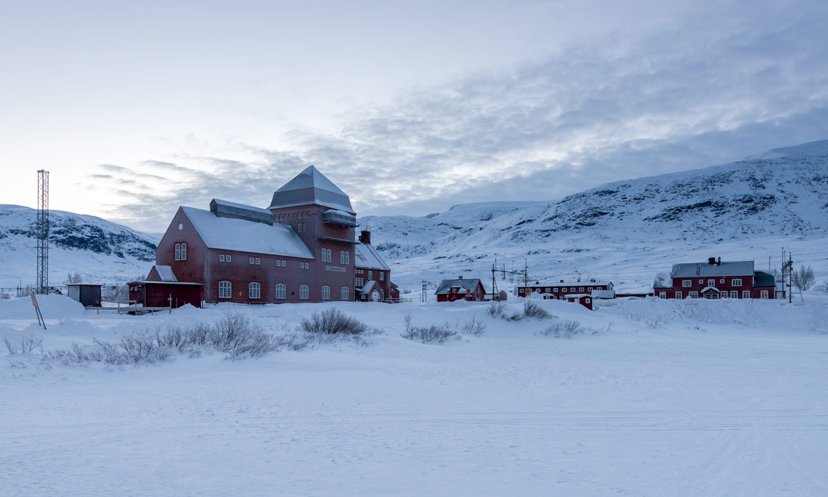
But after a while the road went down again and I turned left to visit Hammerfest. I made a short stop in Kvalsund before I drove over the bridge onto the island Kvaløya where Hammerfest is situated at the western coast.

I know the name Hammerfest for ages, I guess it was mentioned in my children’s encyclopedia. As many other towns in Norway Hammerfest is a modern town, since it was destroyed almost completely in WW2. For me the name sounds quite German, both “Hammer” and “fest” are German words as well. When I had a look in the tourist information I thought, that Hammerfest is a German town, because all people talked German. But that’s probably only because the Hurtigruten was just in town and many tourists that make a cruise with one of these ships come from German speaking countries.

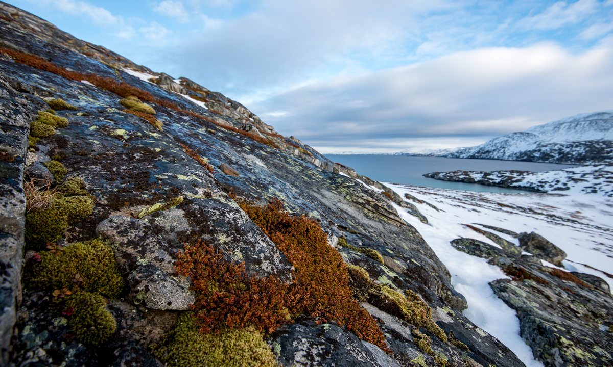
After a shorter strolling through town I continued the road to Forsøl in the north of Kvaløya. Again the road went through treeless, snow covered hills and mountains. But the rocks at the coast showed moss and other creeping plants due to the mild coastal climate.

I returned and planned to continue my journey to Honningsvåg, one of the northernmost towns in Europe. Driving back was not easy in the beginning because the streets where wet and it was hard to see something against the low standing sun, even with sun glasses and flapped down sun shields. But soon the road changed direction and driving became easier. Now I continued the E6 a bit and turned left into the E69 (that’s where I made the pictures of the Purple Sandpipers) that leads to the town Honningsvåg and to the Nordkapp. It started to dawn and even to snow a bit.

After a while it was dark. I could see grey snow, dark rocks and the dark sea. After a while I couldn’t see anything anymore, just the reflecting tape round the plastic marks and the tunnels. Meanwhile we had +3 °C and it rained. (I guess, it can be alike in summer …) Already from distance I could see the lights of Honningsvåg. The last tunnel went beneath the sea and came out again on the island Magerøya. Some minutes later I was in Honningsvåg.

Now I had three wishes: Food, internet and a room. It took a while to find the only open restaurant, a pizzeria. Check! There I was allowed to use the private WiFi to get internet. Thank you, guys! Check! And there, with the help of Annika who was online I found a room in a hostel. Expensive but hey, we’re in Norway. Check!

Now, the morning after, I will have breakfast and then I will pretend to be a real tourist and visit the Nordkapp, the northern most point in Europe you can reach by car.

Purple sandpipers

Day 49

Today in Olderfjord: I only went to the beach to make a photo of the mountain reflecting in the fjord …

… when I came across a huge flock of resting birds that turned out to be Purple Sandpipers. Cautiously I changed the lens and tried to get nearer, nearer, nearer. The birds got a bit nervous but didn’t fly away. But suddenly – I didn’t move at all – the whole flock arose into the air, wheeled over the sea in a large circle, divided into two minor flocks and one of them came back to the place where I stood landing just some metres in front of me. Just great!


Ascent of the Komsa

The second day in Alta. The afternoon I parked my car at the end of the street Tilfluktsveien. My plan was to go up to the top of the hill Komsa. The winter ways turned out to be ski trails and I since I went afoot, I went beside the trail. First I thought about getting my skis, but soon I found a trampled path that brought me to the top of the Komsa. Thank you, locals, for knowing the best way and tramping this path! On the top of the Komsa it was very windy and I sought shelter behind the radio station to change the camera lens. Nearby stood two sheds with parabolic antennas. The green camouflage pattern revealed the military usage. I have to admit that I was a bit nervous standing there with my camera and the long telephoto lens, especially when I aimed directly to the sheds to catch the mountain view above. I’m quite sure that it’s strictly forbidden to take pictures of military installations in Norway as in many other countries. After taking some images (landscape, no military installations!) three soldiers appeared and approached. They went into my direction and they seemed to be in a hurry. (Gulp!) But they just said “hoi”, passed by and entered the wooden house of the radio station. (Phew!) There were not at all interested in my photographing and probably just wanted to avoid the chilly wind. I was reliefed and wandered around a bit. The stormy wind was chilly but the views where so beautiful.

Two other photos of today.

One: The Nordlyskatedralen (The Northern Light Cathedral) in Alta, a remarkable building.

Two: Wakan, an Alaskan Malamute, that will participate the Finnmarksløpet, a 1000 kilometre dog sled race that starts in Alta in a few days. Good luck!

Tromsø: In the mountains

Day 14

Today I was up in the mountains. I took the first cable car at 10 o’clock and had a beautiful view on the town Tromsø below.

The whole day was like a symphony in colours. Starting with deep bluish purple shades and pink pastel tones the light got warmer changing the light to this incredible colour between pink and light orange. Does it have a name? I don’t know.

This time I had snowshoes with me. They weren’t necessary today but after the last mountain hike I won’t go without anymore. I headed for the first small peak called Fløya (671m), just two kilometres away. The views of the multicoloured mountains in all directions were fantastic.

I continued southward to the Bønntuva (776m), the next peak. I really love the patterns that the wind has cut into the crusty snow.

I continued a bit farther to a nameless peak (754m), mostly to make a photo of the pile of stones. Stone piles are used in Norway to mark ways, but I guess some of them are built of tourists just for fun. But the weather was perfect and the terrain quite simple so I didn’t mind the waypoints.

I was slow because I was more into looking and taking pictures, not into being fast. So I decided to turn and go back to the top station of the cable car. But not without taking some more pictures. One of them shows a ship, it’s the Hurtigruten heading Tromsø. I could see it far away more than an hour before it landed in Tromsø.

As you can see on the latter photo sun went down again and the shades turned into pink and purple again. When I came back to the fence protecting the tourists falling down the cliff it was dark enough to start the night photos. Tromsø looks really beautiful when it is illuminated in winter time and sky is still blue.

Half an hour later I took the cable car down and went back to the car. That took a while because the official parking place costs 20 NOK the hour and I was much to mean to pay 13,50 Euro just for parking.

My plan was to continue the journey tomorrow but I changed my mind because of the weather. The Norwegian region round Tromsø and Narvik will get a “liten storm” that matches level 9 on the Beaufort scale with gusts up to 35 m/s (level 12). The Swedish mountain region will get strong winds as well with poor sight and much snow. I’ll start a day later, on friday.

Just an image for the photographers: My cheap thermometer is Arca-Swiss compatible! – 7 °C today.

Car trip to Tromsø – partly nightmare, partly relaxation

Day twelve

Today I said goodbye to my friends that I stayed with the last week and headed to Tromsø in the north which is round 400 km away. I thought about driving as long as I like, making a over-night stop and continuing the next day.

The weather was quite bad. The temperature has increased to +5 °C, it rained and it was quite windy. But travelling was relatively easy until I came to the first mountain passage. And this part turned out to be the most terrible car ride I had in my whole life!

The nightmare part

The rain – sometime mixed with wet snow – became more and more intense, until rain was just bucketing down on the frozen roads. Sometimes I drove through deep puddles, pushing a bow wave like a boat, sometimes deep slush covered the narrow roads that oncoming cars tossed onto my windscreen temporarily reducing sight to zero.

But mostly the roadway was covered with a thick layer of wet new ice that was slippery as hell. So slippery that I hardly could accelerate or break or steer or do anything without starting to slide. Thanks god for the traction control of my Saab. I wouldn’t have managed without it.

Do not forget, I’m not talking about broad Swedish streets, I’m talking about narrow Norwegian streets, that only consists of tiny bends and sharp hairpin curves, roads that constantly go left and right, up and down. And that’s the main road I’m talking about!

And I’m talking about other car drivers. Car drivers that don’t mind the weather but drive as usual: Too fast! And I was way too slow for them. If they were behind me, they glued their car to my rear bumper and I used every parking place or bus stop to let them pass.

I was stressed, I was frightened and I was frustrated! Was it a smart idea to make this winter journey or was it just stupid? Should I skip Norway and head back to Sweden, where roads are broad and straight? I started to understand why many Norwegian roads are closed when weather is bad. I decided not to continue to Tromsø, but to drive back to Abisko, where the streets are better and in addition to that weather is cold enough to avoid these awful wet and icy roads.

The relaxed part

But first I had to continue the same road, regardless whether of staying in Norway or driving to Abisko. But alas, the weather became better and better and so became the streets. Now it was not only easy to drive, it was fun! It felt like I could continue for hours and hours without any effort. And so did I. 19:45, eleven hours after the start in Haukenes, Vesterålen I arrived in Tromsø.

Wait a moment, eleven hours of driving? For 400 km? No, not really. First of all I stopped at two different bays and walked at the sandy, muddy and ice covered shore lines. I love these walks and consider them extremely relaxing.

In addition to that I made a detour. OK, I’ll be honest: I missed the road to Tromsø and had to head back 19 kilometres to Breivik.

And I made a stop and ate a big burger with fries and drank a coke. Driver’s junk food!

Now I’m sitting in my tiny cabin on Tromsø camping and I’m writing this blog article. The radiator tries to heat the cold cabin but it will take some time until it is warm. But I’m wearing my down suit and even my sleeping bag, both are extremely warm and cozy. A cheer for good equipment and overdressing!

Back to Haukenes

Day nine

Today I drove back from Andenes to my friends in Haukenes where I’ll leave on Sunday or Monday. I didn’t choose the direct way on the eastern side of Andøya (82) but the detour on the western side via Stave and Skogvoll. There where some fantastic views, mostly at places where I couldn’t stop. But anyway, some images of today (and two of yesterday):

Let’s start with some houses in Andenes build on stilts (The greenish colour on the second photo comes from the polar light).

Andenes next morning and Bleik, where I took a long walk on the large sandy beach.

A small graveyard and a real tiny light house.

A man hanging up fish heads for drying (for the african market).

And last not least some landscapes when sun went down again.

That’s today in a nutshell.

Whale watching in Andenes

Day eight

To cut a long story short: It’s been a great day!

After watching the beautiful polar light last night I got less sleep than preferred because I drove to Andenes to participate a whale safari. First I had to drive round two hours. After that I had to wait, time I used to put my cameras in waterproof bags. Finally we where equipped with overalls and live vests and entered the big rubber boat. We left the harbour and headed an area where whales have been seen some hours before. This part was a bit tough since we drove against the wind and some waves where quite huge letting the boat rise and fall some meters into the wave troughs again.

But finally we reached the area and directly saw the first whale fins and the first steam blown out through the whales blowholes.

The next two hours we saw a lot of whales, sometimes we where almost surrounded by them. Mostly we saw orcas (that are called killer whales, too) and humpbacks, but some fin whales as well. The orcas are following the herring and I probably came just to the right time to see so many of them. We even saw orca calves that are yellow or even orange instead of white as long as they are breast-fed.

(Oops, the room where I get internet is closing soon, I have to rush a bit …)

For me the most amazing view were the huge humpbacks diving down showing only there big tail fin. And the orca child swimming near its mother. And now to the photos:

As I said – it’s been a great day!

Links:

Sea Safari – Whale & Bird watching Andenes (under construction)

Photoing whales

It’s hard to take pictures of the whales. Sometimes there where quite near, less than 10 meters, but mostly there are farer away and you need a good system camera, a good tele lens and much practise in focussing. The most of my photos were out of focus, but alas not all.

Some of the photographers that joined the trip had real huge tele lenses and I guess the value of the total camera equipment onboard was the same as my house in Skelleftehamn.

Whale names

Latin English German Swedish
Orcinus orca Orca / Killer whale Orca / Schwertwal Späckhuggare
Megaptera novaeangliae Humpback whale Buckelwal Knölvalen
Balaenoptera physalus Fin whale Finnwal Sillval

From Sweden to Norway

Day three (part II)

After leaving the reindeers behind I continued to the Norwegian border. But first I made a picture of the strange looking railway station in Vassijaure, the last photo from Sweden for some time. Soon I reached the village Riksgränsen and right after it the Swedish-Norwegian border. I took the first parking opportunity and made the first photo in Norway of my tour.

Just some miles (a Scandinavian mile is 10 km) later I could see the first fjord. And shortly after this another typical Norwegian happened to me: A construction site with a “follow me” car because due to work in the tunnel the road was only one-way.

I continued on the E10 to Bjerkvik. Shortly before Bogen i Ofoten I took a side road and took a picture of the beautiful sunset colours above the snowy mountains. Soon I reached Bogen and made two other pics:

… and another image in Kongsvika in the dusk:

The whole trip was amazing, mostly because of the varying landscape. Sometimes the road follows the coast line of a fjord, sometimes it crosses the fjell – the mountains. Once temperature dropped from 0 °C to -15 °C within two minutes just because I left the coast and entered the fjell.

I changed plans and made an additional stop in Lødingen where I am right now. When I arrived it was already too dark to take pictures, but I had a nice two-hour evening walk. First I followed the coast line (including wading, almost slipping on the ice and a bit of simple climbing) and then followed a forest path back to civilisation. It was great just walking through the lonely nature after having been sitting in the car for three days!

Tomorrow morning I’ll head to Stokmarknes and take a (late) breakfast with my friends. I’ll stay there for some days and I’m really looking forward to be outdoors instead of sitting in the car.

The magic ice world

Today I was in another universe. At least it looked a bit like it.

After my adventure on the “ice shelf” last night I longed to see the place by daylight. Breakfast was late but so was sunrise and right after I’ve eaten I drove to Näsgrundet again. We had -17 °C (more or less the whole day by the way) and some snow crystal fluttered out of the grey stratus clouds. I put on my grödels – simple crampons – to be able to go on the ice slope. Soon I stood at the rim and looked down into the calmed down sea. The view was quite impressive …

… but …

it would be great to see the ice walls with its icicles from the seaside. It’s not, that I didn’t think about it before, that’s why I had both my waterproof camera and my waterproof survival suit with me. I undressed a bit (not the funniest thing when it’s -17 °C outside) and slipped into the red suit. Then I took the camera and glided into the water. And that’s where I entered another universe. But enough words, the photos! Here they are:

I really loved to paddle in the ice water and to look at the ice walls that where decorated so beautifully wich icicles. Since the attached rubber gloves are waterproof, but not warm at all, my right hand index finger didn’t like the adventure as much as I did and got a bit of frostbite (it still hurts a bit but nothing serious, fortunately). And that’s how I looked like today when I took all these photos:

Winter intensifies

Did I write about the “just normal” winter two days before? Well that changed a bit. Right after I wrote the last article the snowfall intensified and brought 10 cm new snow within 16 hours. It got both windier and colder and still snowed a lot.

Today¹ I took a walk round the small lake Rudtjärnen. Snow fell in thick, heavy flakes and made it impossible to look farther than 100 meters. The squalls whirled up the snow morphing the view into a grey-white nothing. And it was even windier on the slope by the lake. The trees on the 2nd photo were hardly 50 metres away!

That was a nice and not so long walk (which was intended since I don’t want to overstrain myself right after the infection), but it wasn’t enough. I wanted to go out again. And so I did. This time with food and drink, (of course) my camera, my new flashlight and my new down clothes for some testing. I already guessed that I couldn’t drive to the small boat harbour because the way wasn’t ploughed and snow was too deep for my car. So I decided to continue to the peninsula Näsgrundet. What a piece of luck!

I dressed up for cold weather, lit my new strong flashlight and went to the rocky beach. Normally the shore descends to the open sea but not tonight where – I couldn’t believe my eyes – the shore was an ice shelf rising up at least one meter before dropping into a black nothing. I could hear the sea behind but I couldn’t see it. Where am I? What happened? Then I heard a rolling wave and – SPLAT! – I could see water and foam rising high up behind the brink and clashing onto the ice shelf! It took a moment or two until I realised what happened: The brisk northern wind presses the waves ashore where they rocket up into the air several meters. I guess that the water and foam first landed on the rocks where it probably froze almost instantly – remember, it’s -15 °C  out there. The rocks became more and more ice covered until they vanished under a growing layer of ice. When I came to this place this evening some parts of the ice were already two meters above sea level! And still some of the waves managed to toss a lot of water onto the ice where it froze and enlarged the ice shelf. What a fantastic experience!

I was both happy to be out there and a bit disappointed that I couldn’t share this moment. If I at least could take a photo, but how to take pictures of waves when it’s so dark. Wait a moment – dark? – My new flashlight was described as extremely bright – Let’s test. I switched the flashlight to the brightest mode, laid it onto my backpack and adjusted the beam to the waves. Then I took tripod and camera and started to experiment. And that’s the result:

I’m impressed. The new Flashlight is really bright. So bright that I can take such pictures at night time. (For the photo freaks: 1/20 sec at f / 4.5, ISO 1600. 35mm)

OK. The flashlight succeeded the test. But what’s with the rest? I was curious how warm the new bought down parka and down pant would be. I just wore a single layer of woollen underwear and my thin but windproof Norrøna-jacket, mostly to test the fur under the down clothes, that was all. (Not mentioning boots and gloves, of course). I’ve been out more than an hour, first taking pictures, then measuring wind and temperature, than taking my frugal evening meal. And yes – the Marmot down combination is as warm, snugly and cozy as it looks like. Almost too warm when sitting although we had an average wind speed of 10 m/s resulting in a wind chill of  -27 C. That’s good to know.

Now I’m longing to sunrise. I want to visit the spot again and take some daylight pictures. That’s perhaps evan a reason to postpone my journey another day. I’m not in a hurry. But tomorrow, when I’ll visit the place again I’ll wear something less water-sensitive than down, because tonight I always expected a huge monster wave would flood half the shelf and soak me completely.

Finally just two selfies from today, one when I walked round the lake, the other when I sat outside after the evening meal.

Foot note:

¹ As a matter of fact: Yesterday. It will already be Monday when I publish this article.

Some vocabularies for my German readers:

squall – Windböe
down – (hier) Daune
foam – (hier) Gischt
flashlight – Taschenlampe
fur – Pelz

For equipment nerds:

Flashlight: Nitecore EA41 Pioneer
Down clothes: Marmot 8000M Parka, Marmot 8000M Pant. Older (or simpler) models.

Just for the archives:

Friday 2015-01-09 21:45 ca. 30 cm -4.6 °C
Saturday 2015-01-10 13:40 ca. 40 cm -7.1 °C
Sunday 2015-01-09 09:15 ca. 45 cm -8.6 °C
Sunday 2015-01-09 16:55 ca. 52 cm (47 cm backyard, 57 cm front yard) -15.0 °C