


Sæberg – Hólmavík – Ólafsvík
This article is part of the series “2018-08: Iceland”.
Thursday, 6 September
From our overnight stay Sæberg it’s only 177 km to Reykjavík, where we had to return our hired car. That’s not much for one and a half days by car. Therefore we decided to take some more detours.
First we followed the road 68 to Hólmavík, a city on Iceland’s West Fjords. We continued along the coast until we came to a junction, where the gravel road 608 crosses the peninsula. It would be possible to go round the inhabited part of the peninsula, but that’s a detour of 390 km.


Quite near the fjord Þorskafjörður, there’s a small city called Reykhólar. We considered staying there over night but since it was still quite early, we continued instead to the peninsula Snæfellsnes.


The weather had been warm, sunny, calm and friendly for the whole week. But now it worsened, low clouds appeared, it started to drizzle and got very windy. In Ólafsvík – yes, I have my own bay ;-) – we found not only a nice hostel to stay but also a nice restaurant that served us a delicious goat cheese pizza.
Sorry to say, I didn’t make a single photo from Ólafsvík that day. First we were too busy with our dinner, than with re-packing our belongings, because the next day we would have to return our car. Than it was too dark to take photos without tripod and too stormy to take photos with tripod.
The only photo I made is a snapshot I took from the bathroom the next morning. Still stormy, still rainy.

Bathing in Sæberg
This article is part of the series “2018-08: Iceland”.
Wednesday, 5 September
Relaxing in a hot pool.

Relaxing in a hot outdoor pool in Sæberg, Iceland. In the beginning of September. With an air temperature of round 8 °C.

How is that possible? Iceland has so many geothermal areas, where the ground is hot, that hot water is freely available in many places. Our hot pool today had round 38 °C. If you wanted to cool down, you just had to go to the beach of the fjord Hrútafjörður and take a bath there. There the water was at least 30 °C colder. We started with the cold bath, but stayed much longer in the comfort of the hot pool.


Jökulsá á Fjöllum
This article is part of the series “2018-08: Iceland”.
Tuesday, 4 September
Jökulsá á Fjöllum (glacial river in the mountains) is a river in the North of Iceland and offers some interesting places. We chose the road 862 on the western side with destination Dettifoss, Europe’s most powerful waterfall.
After some kilometres the asphalt road suddenly changed into a single-track gravel road, which was in a quite bad shape.

Some kilometres further at the turnoff to the Hljóðaklettar the road to the Dettifoss became an “F” road, meaning that it was open only for off-road vehicles. At least we could turn left to Hljóðaklettar which is known for its basalt columns. Here we parked the car and took a circular walk.


After our walk we had to drive back the whole bumpy road, turn east, cross the river and use the road 864 on the eastern side. It was quite bad, too, but at least we were allowed (and able) to take the road and finally arrive at the Dettifoss. We were lucky, since the eastern shore is more crowded and farther away from the waterfall.
Here some snapshots:


From this place you also have a gorgeous panoramic view of the canyon that leads to the north. If you followed this canyon you would come back to Hljóðaklettar.

From Reyðarfjörður to Kópasker
Monday, 3 September
On this day I took most photos through the windscreen while Annika was driving. But we made stops, too. Some photos:


Polar lights above Kópasker

Through the windscreen
This article is part of the series “2018-08: Iceland”.
Monday, 3 September
Today it was Annika who drove the car. I was front-seat passenger and took photos through the windscreen.
The route today: Reyðarfjörður – Egilsstaðir – Vopnafjörður – Bakkafjörður –Þórshöfn – Raufarhöfn – Kópasker.


As you can see: Nice weather!
As you can see: Not too many cars!
Some more photos to come, perhaps tomorrow …
From glaciers to the East Fjords
This article is part of the series “2018-08: Iceland”.
Saturday, 2 September – from Svinafell to Reyðarfjörður by car
Annika and I woke up quite early and left our cabin in Svinafell already round 8 o’clock. That’s why we were almost alone, when we came to the lake Fjallsárlón into which the glacier tongue Fjallsjökull calves. Some larger and many small icebergs floated on the brown glacier water. We walked along the shore, touched some of the small ice blocks and watched them floating into the creek Fjällsá.


When we left the beach of the lake, many more people arrived, although this “first lake” is not as the “third lake”, the Jökulsárlón. The latter is much more touristic. Many cars stood on the huge parking place and hundreds of tourists walked around, taking pictures or took tours with zodiac boats or amphibian vehicles. The good thing with cold lakes: You always find the opportunity to take pictures without any tourist.


We didn’t see many animals yet on Iceland, beside of many sea birds and of course countless sheep (mostly in groups of three) and Icelandic horses. Here we saw the first wild mammals: seals swimming around in the lake, diving and reappearing again after some time.

After we left these lakes behind and continued east, the traffic on the Ring Road decreased more and more. We were on the way to the East Fjords that are far less touristic than the south of Iceland. It was just fun to drive the Ring Road and watch the scenery changing. Just a few pictures from some of the breaks we made.


It was quite late when we arrived in the coastal town Reyðarfjörður, where we got a room with an own bathroom. Time to cook and wash some clothes.
The next day we would leave the East Fjords and head north.
Black beaches and glaciers
This article is part of the series “2018-08: Iceland”.
Saturday, 1 September
Yesterday we hired our car, today we had the first full travel day round Iceland. We didn’t make many kilometres, since there are so many beautiful places along the Ring Road in the South of Iceland. There are quite famous, too, so we had to share them with a lot of other tourists.
Dyrhólaey
Dyrhólaey is a 120 metre high peninsula which is known for a large hole in the rock that gave the place its name: “door hole island”. Huge waves rolled ashore and broke at the rocks. No place for bathing.


In the east we already could see the Reynisdrangar, pillar-like rock formations in the sea. The sea was covered with spray and looked almost white, just like the sky.

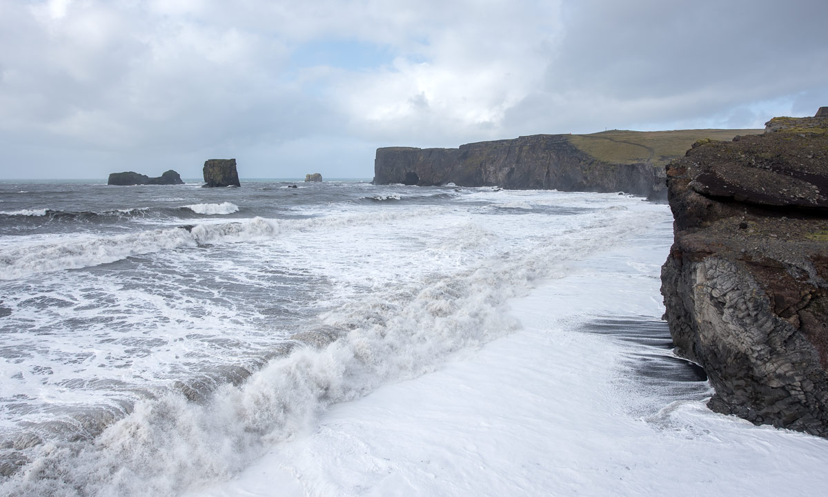
Reynisfjara Beach
Reynisfjara Beach is the most famous of the black beaches near to the town Vik. Unlike most other beaches the sand consists of eroded volcanic rocks. The waves were as high as those visible from Dyrhólaey and many signs warn against the danger of being swept away. The beach at the parking place is quite is flat and white and the waves flood great areas of the black sand.


While I was taking these photos a huge wave came and pushed a lot of water to the beach. I got wet feet even with my rubber boots on.
From here you can also see the Reynisdrangar standing stoically in the sea. Only seabirds inhabit these inaccessible rock pillars.


One of the main attractions of Reynisfjara Beach are the basalt columns. Well, I tried to take photos, but this was impossible due to the many, many tourists standing there. At least the basalt cave was free of people for a minute.


Svinafelljökull
We found a nice overnight stay in Svinafell. As all accommodations it was expensive and you would get a hotel room with breakfast for less money in most other countries. Iceland however is an expensive country and you should know that before travelling there.
Quite near Svinafell there are two glacier tongues, Skaftafellsjökull and Svinafelljökull. Both of them are part of Vatnajökull, Iceland’s largest glacier and you can see them from the Ring Road.

After checking in we returned to the Ring Road and turned into a gravel road leading to the Svinafelljökull. This was the worst road I ever drove. It was just 2.5 km long, but only made of deep potholes and rocks. It took me 15 minutes for one way. There’s a reason why so many people use jeeps or pickups in Iceland. Anyway it was worth the efforts, despite the grey weather.
Some photos:


Next day we would continue east and perhaps reach the East Fjords.
Seljalandsfoss and Glúfurárfoss
This article is part of the series “2018-08: Iceland”.
Friday, 31 August
Yesterday Annika and I went into phase 2 of our Iceland holiday. We hired a car for a week. We had booked a VW Polo but we were lucky and got a brand new VW Golf as an update. That’s a great car to drive the 1332 km long Route 1 round the island (and probably some detours). We got our car at 12:30, went shopping and left Reykjavík as fast as possible to follow the Route 1 counterclockwise.
The first stop was at a huge parking place, where you could see the Seljalandsfoss, a 65 metre high waterfall. It is special in the way, that you can go round watch it from all directions. We were not the only ones, hundreds of other tourists went round as well, many of them without proper rain clothes and soaking wet.


A gravel path led to another waterfall, the Glúfurárfoss. It is not easy to reach, because you have to enter a hollow and wade through a stream to get to it. This waterfall may be less impressive in height and amount of water, but the scenery is more special, almost enchanted than the Seljalandsfoss. I was very glad to have not only rubber boots but also my waterproof camera with me, but half of the time I was busy with keeping the lens dry.


