Company car

Today I sold my Subaru Outback 2008. Now I do not own a car any longer, at least privately.

My company Filchos AB however got its brand new Subaru Outback 2018 today. Luckily I’m both the owner of Filchos AB, the boss and the only employee. Olaf, the boss and Olaf, the employee are on friendly terms with each other and therefore Olaf, the employee may drive the car as often as desired.

My personal key features: permanent all-wheel drive, 20 cm ground clearance, automatic transmission and a lot of space inside. Now I’m longing for the first longer journey to get used to the zillion buttons and levers that modern cars use to have nowadays.


The island Fårö

This article is part of the series “2018-05: Gotland”.

It’s Thursday, our 4th full day on Gotland. Today we want to hire a car, meet Ingrid again and explore Fårö, an island northeast from Gotland.

We return our e-bikes, that we used the last two days and walk to Mickes biluthyrning, where we rent a VW Passat from 1995. Annika drives. We fill up the car and drive to Lärbro, where we meet Ingrid. She has been living on Gotland for a year and will guide us around.

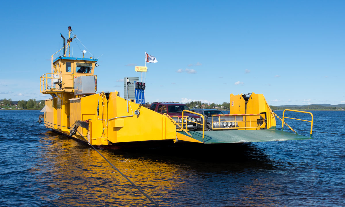
In Fårösund we drive on the free ferry; the ferry crossing takes only 8 minutes. Then we are on Fårö.

First stop: Fårö kyrka. Beside this church used to be a tourist information, but it doesn’t exist anymore. It’s not a big problem, since Ingrid knows all these places she wants to show us.

The next stop however is a request of Annika and me: a real bakery! With a few exceptions, there are no bakeries in Northern Sweden and we enjoy visiting this one. We buy bread and cake and take a break to eat the latter.

We drive through the landscapes of Fårö, which are as varied as Gotland’s landscapes. Sometimes you think, you are in Spain or Greece, sometimes you believe being in Northern Germany and (only) sometimes in Sweden. Now I understand the Swedish people better, who say that Gotland is not Sweden.

Next stop Fårö Fyr, the lighthouse of Fårö, located at the easternmost point of Fårö. There’s a beautiful rock coast, but we do not stay very long, there’s a lot to see.

Next stop Skärsändan, a beautiful sandy beach that is several kilometres long. Annika and I take a bath (the water is quite shallow) and then Ingrid, Annika and I walk barefooted along the beach.

After a longer promenade we continue our Fårö exploration trip. On the way to Langhammars Raukar we make a stopover. Here we find many things typical for Gotland and Fårö: grey sheep, windmills, thatched houses, braided fences and dry stone walls.

Next stop is Langhammars Raukar, one of the famous spots with rauks – steep limestone formations formed by the waves of the sea. On of them reminds me on the stone statues of the Easter Island.

We continue to another fascinating spot, three kilometres away: Helgumannen, an old abandoned fishing village. This group of tiny wooden houses located on a rocky beach that seems to be endless looks really remote and I ask myself what kind of live the inhabitants had.

The last stop on Fårö for today: Gamle Hamn, another spot well-known for raukar. The last photo shows the “coffee pot”. Personally it reminds me more of Buckbeak, the hippogriff in Harry Potter.

I has become late, we are hungry and a bit tired. Ingrid drives the way back to the ferry and soon we are on Gotland again. Here we take the first restaurant and get something to eat, before we drive back to Lärbro and say goodbye to Ingrid.

Tusen takk, Ingrid for a wonderful day!

When Annika and I arrive in Visby it’s so late that the sun sets and the ice cream shop is already closed.

Travel remainders

This article is part of the series “2018-03: Varanger peninsula”.

Some unpublished photos from my winter journey. I want to show them as long it is still wintry here.

2 February – Jokkmokk

While the grown-up huskies are doing their job the puppies have to wait in the trailer. I guess it is very boring for them. There are curious and seek contact.

21 February – Kirkenes

While Chris, Annika, Ørjan and I are enjoying the gorgeous breakfast in the hotel Thon an asian tourist is waiting outside. She seems to be well protected against the elements but why has the fur to be pink …?

1 Mars – Ekkerøy

On the way to Kiberg Annika and I make a stopover in Ekkerøy where we enjoy a beach walk. Here we meet H. who invites us to visit her. We will make that true some days later. I take a photo of Annika’s and H.’s footwear. Tradition, meet modern world.

1 Mars – Ytre Kiberg

Cape East Arctic Adventure, our stay lies directly at the beach. I could spend weeks with only watching the tides and the changing weather.

4 Mars – Ytre Kiberg

There’s hardly any commercial fishing left in the small former fisher villages and the large drying racks for drying cod remain empty. Some people however still dry cod for personal usage.

5 Mars – Ytre Kiberg

A view through the window of Cape East Arctic Adventure. Today we will continue our journey.

10 Mars – Berlevåg

We hardly have the time to explore Berlevåg, we only buy food. Two images of Berlevåg anyway. Just for the records …

11 Mars – Kjølnes Fyr

This snowstorm shaken rocky shore appears more arctic than many other places of this journey.

14 Mars – Hurtigruten, near Øksfjord

A woman has found a wind protected place and watches the Norwegian winter landscape.

16 Mars – Saltstraumen

On our long car trip back from Ørnes to Skelleftehamn we pass Saltstraumen, a small strait with one of the strongest tidal currents in the world. We are too early to see the strongest maelstroms and I’m too eager to continue home. It’s still 500 km to drive.

Now I finally can erase my “later” folder on the computer.


Back home again

Day 44 of my winter journey 2018

Ok folks, I’m tired, let’s keep it short and simple:

 ►►► I hereby declare the winter trip 2018 over.

After a long car ride starting in Ørnes Annika and I arrived in Skelleftehamn at 5 pm and I’m home again.

The part through Norway took a long time as usual because of the road bending and twisting left and right, up and down. The part through Sweden was much faster, but a bit of a bore, since there is not so much to see beside of snowy forests (ok, there is more to see, but not if you just want to come home).

We had blue sky the whole journey and temperatures between -5 °C and -20 °C.

In Skelleftehamn there’s still a lot of snow and the fence in the backyard is snowed under. Just now (19:57) the sky is clear in Skelleftehamn and the temperature is -13.6 °C. No polar lights (yet).

Some random useless facts about the journey:

  • 3798 kilometres by car
  • 59 hours by Hurtigruten
  • 4 different countries
  • -34 °C coldest temperature (and -25.8 °C home in Skelleftehamn)
  • only 1 day with rain and degrees above zero
  • overnight stays at 18 different places (if I counted right)

Some missing blog articles that I’ll write the next days:

That’s all for today,
/Olaf


Why travelling in Northern Norway can take time

This article is part of the series “2018-03: Varanger peninsula”.

Day 40 of my winter journey 2018

At 11 o’clock we left Kjølnes Fyr and started our car trip to Båtsfjord. First we had to take the road 890 to Kongsfjord and over the Kongsfjordfjellet, then we had to continue on road 891 over the Båtsfjordfjellet to Båtsfjord.

I wasn’t sure if we would manage it due to the severe stormy and snowy weather. Another guest staying at Kjølnes Fyr had a hard time driving the 5 km from Berlevåg with very bad visibility. The roads however were still open though marked with a warning “difficult driving conditions because of snowstorm”.

And yes, it was stormy and it snowed a lot. The sight on the road however was still quite good. While I focussed on the road Annika took some photos of the coast beside of the road:

Some parts however were very hard to drive, since the visibility was extremely bad. It was hard to see whether there were snowdrifts on the road and how deep they were and several times I had to stop completely to find out, where the road continued.

I started to doubt if it was possible to cross the mountain passages but we would make it at least to Kongsfjord where we could stay overnight if continuing became impossible. Annika tried to check the traffic information of Vegvesen – the Norwegian Public Roads Administration – but there was no mobile internet available.

I continued driving along the E 890 and the only other vehicle we met was a snow plough. The street behind it however seemed as snowy as before.

Shortly before Kongsfjord Annika’s smartphone was online again and she informed me about the updated traffic information: The mountain sections of both the 890 and the 891 where restricted to kolonnekjøring which means that you cannot drive alone but have to follow a convoy guided by a snowplough. The kolonnekjøring was scheduled to 14:30. The good thing: Driving in a convoy would be much easier than driving alone.

When we arrived in Kongsfjord it was 12:10, so the 28 km drive from Kjølnes Fyr had taken more than an hour. We were lucky that there is a landhandel – a grocery – in Kungsfjord that is open all year. We entered the landhandel, told about the kolonnekjøring and were invited to coffee and cookies straightaway. A big thank you to the owner for the warm welcome!

While we sipped our coffee and waited we constantly checked the traffic informations. After a short while we learned that the start of the kolonnekjøring was postponed to 17:00. That meant more waiting, but we were not the only ones. Other men in work clothes – mostly fishermen – waited as well. They told stories, laughed out loudly while drinking coffee or eating fast food. Anyway we all were still lucky. While we only had to wait some more hours many other roads were completely closed due to the weather, among others the way to Mehamn, the passage between Kiberg and Vardø and the only way to the North Cape.

Hours later: We said goodbye, cleared the car of snow and drove the short way to the boom gate. Here some other vehicles, mostly trucks waited for the convoy to start. One of the truck drivers attached snow chains to his truck.

Dusk had already been falling when our convoy started some minutes after 5 o’clock. My job for the next time was following the rear lights of the car in front.

Some passages were quite easy to drive, some passages were hard to follow due to the blowing and driving snow. (Sorry, no photos.) After 35 minutes we arrived at the T-junction, where the 890 from Kongsfjord, the 890 from Tana Bru in the south and the 891 from Båtsfjord meet. A long queue of cars coming from Tana Bru already waited. Some minutes later the convoy from Båtsfjord arrived as well. The snowplough leading the convoy to Kongsfjord passed and seconds later our queue of cars started to approach the intersection were we turned left to follow the convoy to Båtsfjord.

This part of the trip was extremely exhausting. It was dark, the convoy was slow and mostly the visibility was really bad. I just tried to follow the red lights in front and it felt like hours and hours until the snowplough turned right and we suddenly arrived in Båtsfjord. Here it seemed to snow as much as in the mountains and I was very relieved when I finally parked the car at our overnight stay. Phew – that was no easy ride and I’m really grateful that convoys led us over the mountains under the snowstorm conditions.

The rest of the day? Buying foodstuff at REMA 1000, eating fast food, falling asleep quite fast while the snow squalls over Båtsfjord continued. According to our host 30 cm of snow already had fallen that day and more was expected.

At least we arrived in Båtsfjord, probably our last overnight stay on land. The next evening we would take the Hurtigruten to Ørnes, were we would drive home to Skelleftehamn and Umeå.

(The first five photos were shot by Annika. I did the editing.)

Over the kalfjell to Berlevåg

This article is part of the series “2018-03: Varanger peninsula”.

Day 38 of my winter journey 2018

The Varanger Peninsula has many inhabited places at the coast, but you cannot take the car and drive around the whole island, not even in summer. There are three roads:

  • The E 75 to Vardø via Vadsø. In summer you can continue to Hamningberg, but this place has been depopulated since 1964 though some houses are used as summer cottages.
  • The 890 to Berlevåg via Kongsfjord. In summer you can continue to Store Molvik, but there are only summer cottages.
  • The 890 and 891 to Båtsfjord.

We explored the towns connected by the E 75 so far. Yesterday however we left the Varanger Peninsula, visited the Sea Sami Collections in Byluft and spent the night in Seida near Tana. Today we continued our trip and entered the Varanger Peninsula again, this time using the 890 to Berlevåg.

A local in Ekkerøy had warned us about this road, which leads about the kalfjell – the bare mountains above the treeline. The weather conditions can be severe and the road can be closed anytime due to bad weather or only accessible by kolonnekjøring, which means that you drive in a guided convoy led by a snowplough. Mostly it’s not snow that is the problem, but strong winds, that can create impassable snowdrifts within minutes.

The weather today however was fine and we didn’t have any difficulties in crossing the kalfjell. The road is really exposed to the elements and I can imagine that the very same road will be completely impassable in stormy conditions.

There is however another possibility to travel from one place to another: using the Hurtigruten ships, that connect Berlevåg, Båtsfjord, Vardø and Vadsø on their way from Bergen to Kirkenes.

Travelling to the Varanger peninsula

This article is part of the series “2018-03: Varanger peninsula”.

Day 28 of my winter journey 2018

Yesterday Annika and I said good-bye to our friends Chris and Ørjan who live near the Snowhotel in Kirkenes. We wanted to continue to Vadsø on the Varanger Peninsula for an overnight stay. After breakfast, packing and saying good-bye we left at 11 o’clock. We followed the road 885 coming from Bjørnevatn and turned left into the E6 in direction Alta/Narvik. Right before the turnout to the airport we came to a stop. Some cars before us had stopped, one driver talking to a policeman. The other cars turned and we stood in the front. There we spotted a huge road sign “Closed, info telephone 175”.

The policeman told us that the E6 had been closed for some hours due to an avalanche that had to be blasted away. That could take some other hours. The E6 is not only the main road through Norway, it’s also the only way from Kirkenes to the Varanger Peninsula. So we returned to Kirkenes.

We ate some lunch, visited some shops and the library and waited for the road to be opened again. After some time it looked like the road would be opened round 14:00 so we gave it another try, were stopped again and told that the snow removal could take some more hours. We returned again, this time to our friends house ready to stay.

We went to the Snowhotel and told Chris about the road closure. Just after we told her that we would stay for another night the website informed us, that the road was usable again. I took a picture of the beautiful entrance hall made of snow and ice by a Russian artist, …

… we said good-bye one more time and took the very same roads again a third time. This time we were lucky, the road was opened and completely free of snow. We followed the E6 to Varangerbotn where we took the E75 to Vardø. Some hours later we were in Vadsø where we had our first couchsurfing experience.

Couchsurfing is a platform where people can host other people for free. It’s both great for finding a place to sleep and interesting people to meet. Our host, Nils Õun from Estonia was a really great host. He’s a professional cook and he made us a creative and gorgeous dinner. We talked and talked many hours and Annika and I were really glad to had the opportunity to meet him. Just a snapshot of the best chicken I ate in the last years, part of his dinner:

As I mentioned before was Nils a great host. Aitäh, Nils!

(Sneak preview: today we continued to Kiberg where we’ll stay for some nights. One of the nice and special places on the Varanger peninsula.)

Winter is just some miles away …

Let’s face it: The weather in Skellefteå and Umeå has been nasty the last days – temperatures above zero and a lot of rain making the minor roads icy and incredibly slippery. Most of the snow of the days before has been thawing away. So just now there’s much more winter in Germany towns than here beside the coast of the Baltic Sea.

The good thing: winter is not far away. I was in Umeå today and Annika and I drove westwards to catch a glimpse of winter. First it continued raining a good while, the road was dark and wet and the snow was slushy and ugly. But suddenly – just within a few kilometres the weather changed and rain turned into snow. Snow fall increased and anything was snow covered and white: the roads, the trees, the traffic signs, the bogs and the parking place where we stopped to visit the Hägring (english: mirage).

Hägring is an artwork between Bjurholm and Vännäs. It is a church-shaped object built of mirror fragments and stands in the midst of a bog. We’ve been there in May and knew that the bog is wet but safe to walk on. It was funny anyway to walk through knee-deep snow and feeling the bog bouncing underneath our feet with each step.

We continued westwards, Annika was driving and I was navigating and taking some pictures through the windscreen. Right after Bjurholm we took a minor road to Örträsk, a village by the lake Örträsksjön. Everything was snow covered. We stopped at the small grocery to buy something to drink but it was closed due to the “snow storm”. Well, we knew of the level one weather warning but it didn’t seem so severe.

Since days in December are short (and we didn’t find a place to eat in Örträsk) we decided to return to Umeå but on another route taking some minor roads eastwards. Snow fall intensified but still only some centimetres covered the roads.

While we followed the small ways the snow on the road got deeper and deeper until Annika’s Golf ploughed through 10 cm of snow. Where there was a house, people were outside to clear the snow with any available tool – from shovels to quite huge shovel loaders. But we didn’t get stuck.

Finally we reached the European route E12 which runs between Mo I Rana (Norway) and Helsinki (Finland). Even this road was covered with snow but much better to drive than the smaller forest roads before. 66 km to Umeå and it was snowing almost the whole way back. The last part however we came into the more maritim and warmer climate of Greater Umeå area and snow turned back into rain. We however got our winter impressions. Within just in half a day! One of the big advantages of living here!

On a final note, a “making-of” photo of Annika: Me walking to the Hägring:


Stormy farewell

Today I sold my Saab 9-5 – the first car I ever had in my life. I bought it in March 2011 when I realised that a life without car is quite limiting in Northern Sweden.

Since then I have travelled to many places as e.g.: Abisko · Alta · Arvidsjaur · Bodø · Gällivare · Hammerfest · Höga Kusten · Jokkmokk · Kirkenes · Kiruna · Kusfors · Lofoten · Loma Vietonen · Luleå · Mosvik · Narvik · Nordkapp · Pajala · Senja · Solberget · Tromsø · Umeå · Vesterålen · Äkäslompolo · Örnsköldsvik

Do you know, how many places in the list are in the south of Skellefteå? Exactly three and Höga Kusten is the southernmost place I have gone by car because normally I head northwest or north.

Today however I sold my car to H., a friend, who lives in the county of Kalmar, more than 1000 km in the south. Funnily enough it’s the very same friend who visited me in 2011 and test-drove the car before I bought it. Back then he said “Well, if you do not buy this car, I’ll take it”. Well – now you got it H., with only six and a half years delay.

Since the Saab is a great winter car – it started without any problems in -35 °C – the elements bade it a stormy farewell with heavy wind gusts and squalls plus round 20 cm of new snow.

My new car is a Subaru Outback, which I bought half a year ago. Less comfortable than my Saab and a bit shorter but equipped with All Wheel Drive. Today I could test it and can confirm that the Subaru had no problems with driving through 20 cm of snow and crossing snowdrifts twice as high. I took some photos but soon drove home again since it was so stormy that it was almost impossible to take photos in the snowstorm. In addition to that I considered the weather potentially dangerous, at least near trees or power lines.

Some winter tours are already planned: A trip to the winter market in Jokkmokk and a longer trip to Kirkenes and the Varanger Peninsula, the northeasternmost part of Norway. And there’s probably much more to come …

Some hours later. It still was snowing. 40 to 50 cm of snow cover my back yard. The snow flakes melt on the lens and create funny plankton-like reflections. In Umeå it already had started to rain and here the temperatures were raising as well. A pity!


757.5 – from Mosvik to Skelleftehamn by car

Last week I’ve been in Mosvik (Norway) to visit friends. Yesterday I drove back home, not directly but with a detour via Nordli and Røyrvik (Norway) and Stekenjokk, (Sweden).

According to google maps the direct way is 671 km, taking 8 h 38 min. With the detour it is only 67 km, but 1 h 46 min longer. That says a lot about the small and steep gravel roads near the Swedish–Norwegian border …

For me the journey didn’t take 10.5 hours, but more than 15. For one thing I don’t drive fast, especially in Norway and for another thing I took many smaller rests for taking pictures as well as a lunch and a dinner break. I left at 9 o’clock; at quarter past midnight I finally was home again. Total distance by car: 757.5 km.

See my travelogue of the journey by clicking the first image and navigating through the images. Swipe on touch devices and click or use arrow keys on other computers.

By the way: After nineteen articles without any photo with snow, this is the first article showing at least some patches of snow again.