A tour to the easternmost point of mainland Norway
This article is part of the series “2018-03: Varanger peninsula”.
Day 29 and 30 of my winter journey 2018
Yesterday we continued our journey to Ytre Kiberg which is 13 south of Vardø, one of the Hurtigruten stops. We started in Vadsø – another Hurtigruten stop – after a breakfast with our host Nils, bought a basis of food for the next days and took the E75 northwards. We made a stopover in Ekkerøy, a village on a peninsula near Vadsø. We like this place and will try to stay there for some nights next week.
At lunchtime we reached Cape East Arctic Adventure, our stay for four nights. We were welcomed by Trond, the owner and operator of Cape East Arctic Adventure and were shown our cozy bedroom, the kitchen and the homely living room. After making ourselves at home we went along the beach to the village and the harbour.

In the evening we were invited to a three course dinner based on freshly caught cod: Fish soup – cod with potatoes and carrots and finally cod roe. Everything was extremely tasty and it was Annika’s and my first time where we tasted cod roe. Yummy!
In Kiberg you are as east as you can be in the Central European Timezone, therefore sun is rising already at 6:24. I was awake very early and took a morning walk round 6 o’clock. Some snow drifts had been created by snow and wind over night but now the weather was less windy and quite sunny. At least for a short time. While I went the way to Indre Kiberg clouds approached, wind increased and it started to snow. It was hardly imaginable that it was sunny just a short time before. Weather changes here quite often as Annika and I should find out later.


After breakfast Annika and I took the car to the other side of the village, put on our snow shoes and started a hike to Kibergsneset, easternmost point of mainland Norway. This place is more east than e.g. St. Petersburg, Kairo or Istanbul! It was windy but quite sunny, when we started our tour but weather changes fast on the Varanger Peninsula:


Actually this hike is just a promenade but the weather may transform it into a small expedition. We were exposed to wind and snow and grateful, that we didn’t experienced a full storm. The weather was rough anyway and I was glad about my windproof jacket and two pairs of mittens.


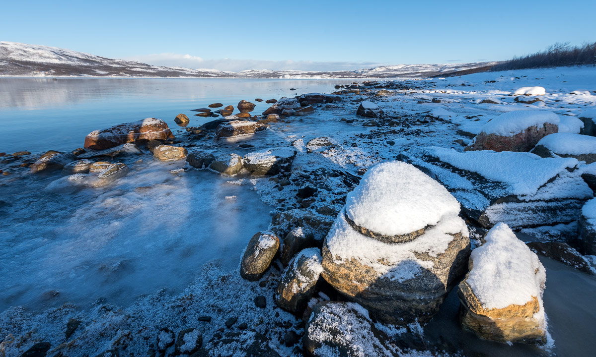
We continued on a small hiking trail, first with, then without snowshoes because the thin snow layer was hardened by the wind and easy to walk onto. There’s a coastal fortress build by Germans in WW2 on Kibergsneset but we couldn’t see it in the snow weather. Instead of looking for it we continued to the small lighthouse at Kibergsneset that marks the easternmost point of mainland Norway (and most of Europe). Shortly before we reached it the sun came out and we continued the last metres in full sun. While I made some photos a small snow shower approached with the sun still shining.

From the lighthouse there was an amazing view over the arctic coast of the Barents Sea, but only for some moments. Soon the next snow shower came by and hid most of the view onto both the coast and the sea.

The way back was much shorter because we knew the way and went downwards. Even though the view was limited by the snow showers Ytre Kiberg came into view again soon and surprisingly the weather was nice and sunny again.

After this very windy promenade we were glad to find shelter in my car. We took the car to Vardø to eat something and after that we tried the road to Hamningberg. We knew that the road was closed in winter but we curious how long we would come.
Well, not very long. We managed to get to Smelror, some kilometres north from Vardø.


The main road however was definitely closed as you can see. There are no people living in Hamningberg permanently and the only motorised way to reach it in wintertime is by snowmobile. For car it is open less than half the year.


We took the car back to Kiberg, enjoyed the incredible and unbelievable colours of the sky and were surprised by a strange weather phenomenon: -6 °C and rain (including a faint rainbow!)

The rest of the day? -10 °C and wind outside, no more photos, no more excursions.
Fun fact: We took the E75 northwards. If you would take it southwards you could travel more than 4000 km and finally would arrive on Crete, Greece.