Continuing to the Vesterålen

This article is part of the series “2015-07: Lofoten and Vesterålen”.

Our third day started with a lot of rain. We put the wet tent into the car and continued our tour to Kabelvåg where we visited a friend of mine. We took a small mountain hike but it was cloudy and wet. Only far away in the east you could see some sunny patches on the top of the snowy mountains.

After the hike Delle and I looked for a camp ground. But first I had to take a picture of the beautiful rainbow near Sildpollen.

This time we tented on a bigger campsite in Sandsletta. When I woke up quite early the next day I could see another rainbow over the Vatnfjorden, but later it started to rain and pour down again. And again we put the soaked tent into the car. We continued on the road 888 to Fiskebøl. The clouds were hanging low and you could hardly see any mountain, just some white and light grey schemes.

Soon we arrived in Fiskebøl where we waited for the ferry. Again we were lucky – we waited hardly half an hour until we entered the ferry for the short crossing to Melbu, the southernmost city of the Vesterålen. We visited friends of mine, this time in Haukenes were we tented near the friend’s house. The cocks tried to wake me up ridiculously early, but in vain. I continued sleeping until 8 o’clock.

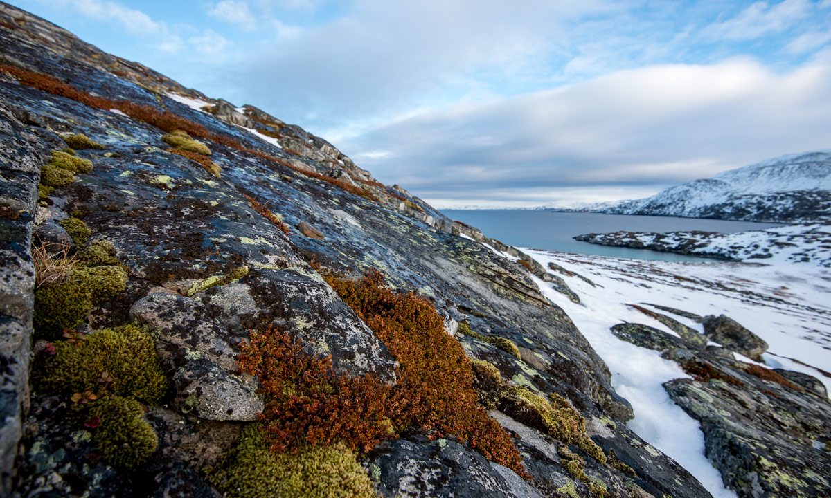
Alas it was the first morning without rain (and the only one, too) and we could dry the tent. After a long and lazy breakfast with my friends we said farewell and continued our car trip. We got a tip to visit Stø at the northern end of the Vesterålen island Langøya. What a good tip and what a beautiful landscape – especially after the weather was nice and sunny. We made a short photo stop between Strengelvåg and Klo before we continued to Stø.

In Stø we parked our car and took a short hike over the mountains to a beautiful white sanded beach were we made a rest and I took a short bath. There’s a 15 km hiking trail as well; next time I’ll definitely will go it.

After our rest we slowly walked back and continued by car. First we had to head south to Sortland were we crossed the Sortlandsundet and headed north on the other side. The sky became more and more cloudy and we looked for a nice campground. Finally we found one in Bleik, quite near Andenes, a town at the northern end of the Vesterålen. We put up the tent and – guess what – it started to rain.

It had been raining the whole night and it continued raining. Again a soaking wet bunch of a tent lay in the back of the car. After a while of driving through the greyness we decided to head back to Skelleftehamn. It’s more than 900 kilometres and it took the whole day. Rain became less near Abisko and after we passed Jokkmokk the sky cleared up and we could see the full moon slowly rising. The next photo, which is the last of our car trip through the Lofoten and Vesterålen is taken near Storforsen, one of Europe’s biggest rapids. At 23:50 we were in Skelleftehamn again – and I was home.

  • 2296 kilometres in six days
  • a lot of clouds and rain, but two nice and sunny days, too
  • one night in the car, four in the tent (three of them on campgrounds)
  • two bathes and at least four rainbows
  • – a nice trip!


From Å to Rystad

This article is part of the series “2015-07: Lofoten and Vesterålen”.

Day 2

Next morning when we woke up in Å we could see blue sky through the fogged car windows. The rain has stopped. We made a walk through the little fishing village and had breakfast on the cliff with a fantastic view on the mountains and the sea.

After that we continued our trip through the incredible landscape of the Lofoten. We had to stop several times to take pictures, for example of this small mountain lake near the road to Nusfjord:

Later we came to a place that became quite famous over the years: Uttakleiv – a beautiful sandy beach that just invites you to jump into the turquoise-coloured water. It almost looks Caribbean but as soon as you enter the ice cold water you’re reminded of being in Northern Norway, not in the south. The bath was fun, anyway.

Here we stayed for a while and enjoyed the sun. But after a while we continued our road trip to Brenna on the island Austvågøy. We didn’t find a camping ground at the end of the road and turned, but soon we stopped the car again. Actually because I wanted to take pictures of the sheep that lay at the sandy beach, but some children nearby discovered something much more interesting: A fox cub. I changed to the telephoto lens and I came quite near. Probably the fox hadn’t made any bad experiences with humans yet.

After that we stopped at a camping ground near Rystad that we already saw on the way to Brenna and decided to stay overnight. Soon the tent was put up on the grassy ground. Slowly the sun went round the mountains and sank down. The next hours were incredible – the light was so wonderful, both the sunlit main land in the south and the sea in the north glowed in the most fantastic colours. But have a look by yourself:

Round one o’clock we lay down in our tent, but only because clouds came and it started to rain a bit. What a wonderful first day on the Lofoten!

On the way to Å

This article is part of the series “2015-07: Lofoten and Vesterålen”.

Day one

Å is not only the last letter of the Norwegian alphabet, it’s the name of some places, too. The probably most known  is Å i Lofoten, the southmost village of the Lofoten islands.

Delle, a German friend of mine and I started the tour last Saturday. The only plan was to take the car, drive to Bodø and take a ferry to the Lofoten islands, the same day or the other day.

The weather in Skelleftehamn was fine but in Arjeplog, where we made a lunch break it started to rain. We continued our trip to Bodø over the mountains. They were wrapped in clouds and were still partly covered with snow.

17:30 we arrived in Bodø, just in time to get the ferry to Moskenes on the Lofoten. Normally I love to be outside all the time when I’m on a ship but this time the sky was so grey that you hardly could see anything. The Lofoten with its more than 1200 meter high mountains came in sight just some minutes before we arrived.

We left the ferry with Delle’s car and drove the 5 km to Å, where it rained so much, that we decided not to put up our tent but to sleep in the car. I put on my rain cloth and made a short evening walk but soon returned to the car. The only pictures I made that evening were the fish heads on the wooden racks drying in the salty wind.

Kirkenes: A night in the snow hotel

This is perhaps the most special place of the whole Nordkalotten 2015 journey to write my blog: On the bed in the room of the snow hotel. Behind me a warm sleeping bag, beside me a snow relief of husky dogs running.

But its a perfect match to my afternoon, where my friend had a half day of and I got a wonderful private dog sledding tour. Parts of the trail where prepared perfectly, because they were part of the Finnmarksløpet – a 1000 km dog race from Alta to Kirkenes and back again that happens right now. First I sat and enjoyed gliding through the landscape effortlessly, but on the flat sea ice of the Langfjorden I could stand on the sledges blades and steer the dogs by myself – a really easy terrain for beginners like me – and I have to admit that this is much more fun than just sitting.

A great two hour tour, thank you, C.! The only disadvantage as a photographer, most of the time you see bums and tails, but if you ignore this, it’s great fun!

Later on we got a three course dinner which was very good. To be honest, that was almost the main reason, why I booked the snow hotel night. I’ve slept in igloos before, but of course not in such a huge one with a three course dinner before.

This night is a good end of my journey. Tomorrow I’ll head home. I’m stuffed with sensations and impressions and I’m longing home. But before I went into my room, I even got some polar light again after a quite long time of abstinence.

Now I have to close, the laptop runs out of battery and I start getting cold.

Good night!


King crab fishing

Yesterday I was on one of the tours, that the Kirkenes Snow Hotel has in its program: King crab fishing. These huge crabs are caught in big crab traps.

First we were provided with scooter overalls, big leather mittens and helmets, because we were driven to the place by snow mobile. The crab trap of the snow hotel is located at the end of the Langfjorden. Normally it would be necessary to free the hole from new ice but yesterday it was too warm and the trap, that looks like a big cage, could be pulled up directly. And yes – we were lucky – a lot of king crabs were in the trap. Bry, the guide, took four of them and showed them to us. There are fascinating animals and looking at them closer they look like aliens.

Gry killed them with a knife and they’re dead in a split of a second. Then she took the legs, that’s the eatable parts and threw back the rests that instantly were eaten by cods swimming around. We took the snow mobile to the restaurant, Gry driving, me sitting behind her and the other seven tourists in the trailer. There’s an outside kitchen where the crab lags are steamed for 16 minutes. They look red after steaming. They’re eaten with white bread, butter, lemon and mayonnaise and they taste extremely delicious. I ate lobster twice in my life and many other types of crabs and crayfish but I liked king crabs best. And there’s a lot of meat in the legs. Three legs were more than sufficient to be full, I ate four and really was stuffed. Delicious!


A first day in Kirkenes

What a beautiful morning! -6 °C and blue sky. I was accommodated near the Kirkenes Snow Hotel where my friend I’m staying with works. I had a look into the Snow Hotel first, It has an impressive lobby with tables and a bar and round about 20 rooms where tourists can stay over night.

After looking around I drove into the centre of Kirkenes and had a walk at the port. First I discovered the commercial fishing part: Big piles of traps for the big King crabs and fisher boats lettered with latin and cyrillic letters. But not far away you could see the touristic part: The Hurtigruten ship Kong Harald that landed nearby.

I walked at the shore a bit and tried to make photos of the big ice floes that lay ashore but clouds had approached and the light was a bit dull. So I took the car and took the road E105 to Му́рманск (Murmansk). No, I didn’t plan to travel to Russia but I wanted at least to see the Russian border. It’s not far away and soon I parked my car just in front of the border.

I’m child of the cold war. It was great to see, that there is a normal border now (even if you need a visa for travelling to Russia) and that you are allowed to take pictures. On the other side this border seemed to be more the “end of the world” to me than the North Cape. On the right-hand side there is the lake that is marked with orange warning signs. This is part of the Norwegian–Russian border that crosses this lake. You shouldn’t set foot on the lake, but at least I went to the shore to take a picture of the Russian custom.

Maybe I will cross this border one day and take the car or the bus to Murmansk, who knows …

It already started snowing on the way to the Russian border but on the way back the snow fall intensified. It was still easy to follow the road but hills that very a bit farer away where hardly visible.

Back at the snow hotel it was still snowing a lot and quite windy but warm as well: +1 to +2 degrees. Some of the 140 huskies were still out on tour while the rest of the dogs could take it easy.

The forecast for the next day promised sunny weather. We’ll see …


Finally: The North Cape

Day 50

To be honest: I never planned to visit the Nordkapp (The North Cape), but when I was in Alta I continued to Hammerfest and after that I travelled to Honningsvåg and from that place it’s only 29 kilometres. So I visited the North Cape yesterday.

The first part is a normal road showing some beautiful views. I also completed 5000 km on this road.

If you go to the North Cape in winter by bus or your own car, you have to drive the last part in convoy. Convoys are starting at 11 and 12 o’clock.

When I came to the convoy place I was an hour too early. Time to try to make a rest on a wooden bench (it was degrees above zero again), but the wood was too wet to stay.

11 o’clock we started. The snow plough came first, then two minibusses, then me and two other cars. The street seemed to be alike as the first part: Snow and mud, partly frozen and some steep passages. The weather changed every single minute and I looked into a rainbow while following the other cars.

When we arrived I parked my car, almost jumped into the building to get an entrance ticket and ran to the famous landmark to make a photo with the rainbow without any other tourists. Even although the rainbow started to vanish I was lucky and I got my pictures. Only my own shadow was unavoidable.

But more than of the landmark I was fascinated by the weather. You could see single rain showers wandering over the sea like extraterrestrial animals and I never saw the weather change so fast and so often than yesterday at the North Cape.

I wandered round and made some photos, both inside and outside. I saw fog and approaching and I saw the many tourists, that came in big busses with the second convoy. I had a look into the tiny chapel in the basement and I ate a waffle with Norwegian cheese, jam and whipped cream.

And of course I made a selfie.

I took the convoy back at 1 o’clock (the earlier one) and I was alone. But so I had time to take the car on another road and drive to Gjesvær, a little fishing village in the northwest part of the island Magerøya. I had to stop again, the light on the far mountains was just breathtaking and the photo is just a poor copy of reality.

There’s apparently no tourism in Gjesvær under the winter but I could see several fishing boats going out and coming in.

After a short strolling I returned back over the fjell until I was at my hostel in Honningsvåg again.

The North Cape – is it worth a visit?

Even if I’m usually not attract by touristic attractions I do like the place somehow.

Yes, it’s neither the northernmost point of mainland Europe (that’s Cape Nordkinn near Mehamn), nor even the northernmost point of the island Magerøya (that’s Knivskjellodden), but it’s a symbol! A symbol for being at the north peak of Europe and as long as you travel by car it is the northermost place you will reach.

I wouldn’t travel far just to reach the North Cape but when you are nearby I think it is worth both the travel and the entrance fee of NOK 255. If you have your own car, take the first convoy and you will get a chance of taking pictures without a zillion other tourists, at least as long it’s not too foggy.

For me this is kind of a peak of my journey Nordkalotten 2015 and now I’ll travel southward again. Probably Karasjok today and Kirkenes tomorrow. What I will do after this depends on the weather. If winter still is much too warm as most of the time I might return to my house in Skelleftehamn and take it easy for two weeks before I drive to Finnland again the last free week. But we’ll see. No plans yet …

5000 km

Day 50

Hooray, I had a travel jubilee today! My journey Nordkalotten 2015 turned 5000 km this morning. My car found a fine place for the jubilee and I just stopped on the road to take some pictures (when I took the picture of the 000.0, the car was still rolling). Dear Saab 9-5, thank you for supporting me on this long trip. What would I do without you.

By pure chance it is also day 50 of the journey, that means I had an average of 100 kilometres a day (including all the days where I didn’t even touch my car).

Hammerfest and Honningsvåg

Day 49

Quite early I left Alta yesterday and continued the E6 in direction Kirkenes. To the left I could see the Altafjorden but soon the street turned right and went a bit up. Half of the Finnmark is above the tree line and so are parts of the E6. But it’s still amazing that you leave the coastal area with green pine trees and wet snow and after a bit of driving up you are in an area with snow covered mountains and just some downy birches here and there.

But after a while the road went down again and I turned left to visit Hammerfest. I made a short stop in Kvalsund before I drove over the bridge onto the island Kvaløya where Hammerfest is situated at the western coast.

I know the name Hammerfest for ages, I guess it was mentioned in my children’s encyclopedia. As many other towns in Norway Hammerfest is a modern town, since it was destroyed almost completely in WW2. For me the name sounds quite German, both “Hammer” and “fest” are German words as well. When I had a look in the tourist information I thought, that Hammerfest is a German town, because all people talked German. But that’s probably only because the Hurtigruten was just in town and many tourists that make a cruise with one of these ships come from German speaking countries.

After a shorter strolling through town I continued the road to Forsøl in the north of Kvaløya. Again the road went through treeless, snow covered hills and mountains. But the rocks at the coast showed moss and other creeping plants due to the mild coastal climate.

I returned and planned to continue my journey to Honningsvåg, one of the northernmost towns in Europe. Driving back was not easy in the beginning because the streets where wet and it was hard to see something against the low standing sun, even with sun glasses and flapped down sun shields. But soon the road changed direction and driving became easier. Now I continued the E6 a bit and turned left into the E69 (that’s where I made the pictures of the Purple Sandpipers) that leads to the town Honningsvåg and to the Nordkapp. It started to dawn and even to snow a bit.

After a while it was dark. I could see grey snow, dark rocks and the dark sea. After a while I couldn’t see anything anymore, just the reflecting tape round the plastic marks and the tunnels. Meanwhile we had +3 °C and it rained. (I guess, it can be alike in summer …) Already from distance I could see the lights of Honningsvåg. The last tunnel went beneath the sea and came out again on the island Magerøya. Some minutes later I was in Honningsvåg.

Now I had three wishes: Food, internet and a room. It took a while to find the only open restaurant, a pizzeria. Check! There I was allowed to use the private WiFi to get internet. Thank you, guys! Check! And there, with the help of Annika who was online I found a room in a hostel. Expensive but hey, we’re in Norway. Check!

Now, the morning after, I will have breakfast and then I will pretend to be a real tourist and visit the Nordkapp, the northern most point in Europe you can reach by car.

Purple sandpipers

Day 49

Today in Olderfjord: I only went to the beach to make a photo of the mountain reflecting in the fjord …

… when I came across a huge flock of resting birds that turned out to be Purple Sandpipers. Cautiously I changed the lens and tried to get nearer, nearer, nearer. The birds got a bit nervous but didn’t fly away. But suddenly – I didn’t move at all – the whole flock arose into the air, wheeled over the sea in a large circle, divided into two minor flocks and one of them came back to the place where I stood landing just some metres in front of me. Just great!