A ski tour in the Kvikkjokk mountains – day 7 to 9

This article is part of the series “2018-02: Ski tour near Kvikkjokk”.

Day 13 to 15 of my winter journey 2018

(finally the last part about Jonas’ and my ski tour five weeks ago)

Tuesday, 13 February

I woke up in the cabin Tarrekaisestuga at 7:20. Some more centimetres of fluffy snow had fallen over night and it was still snowing slightly.

While Jonas and I had breakfast the snowfall intensified so that the mountains and the opposite shore of the lake Darrávrre were hidden by the falling snowflakes. Even the deep tracks of our pulkas from the day before had been snowed over and we couldn’t spot them anymore. We planned to gradually walk back on the other side of the lake and find a tenting place there. After breakfast we packed our equipment into the pulkas, cleaned up the cabin and started our tour by crossing the lake. It was still snowing quite heavily and on the lake it was quite windy, too.

It was not easy to find a path on the other side of the lake. The snow was soft and deep, some parts were forested quite densely and some passages were quite steep. At least for me, who lacked both power and general fitness for dragging a heavy pulka uphill through this sort of powdery snow where you sink in 20 to 40 cm with every step – with skis on!

Slowly and with many small detours we managed to ascent the southern hills until we reached the treeline where the terrain is more open and less hilly. We found a boulder where we found shelter against the wind. Here we took a snack: Chocolate, trail mix and hot tea.

We continue skiing slowly going uphill heading east. It stopped snowing and the wind dropped but the weather was still grey and dull. At least we could see the mountains again.

Suddenly we came to an abrupt stop. We stood at the edge of a deep, steep ravine impossible to cross. Such can happen if you do not make a detailed tour planning but just have a general idea of where to go.

After a while we started to look for a place to tent. First we followed the ravine that the river Áhkalmgårttje had cut into the landscape then we descended a bit to find a sheltered place between some birch trees. The snow was really deep and without skiers I sank up to my stomach into the fluffy snow.

Fortunately the snow was stable enough to build up the tent after we had trampling down it thoroughly with our skis.

Later in the evening: I wonder, why it is never completely dark. Is it still lights of civilisation reflected by the clouds? Suddenly something was flickering between the clouds. Is it a strong aurora? No, it’s just too vivid. But what is it? It was two snow mobiles that illuminated half the mountain landscape with their strong full beams. Slowly they passed on the lake below us.

Temperatures were round -10 °C, quite warm for a February night in the Kvikkjokk mountains. Soon I fell asleep.

Wednesday, 14 February

As usual I was awake quite early and I had a challenge: going on the loo. I just slipped into my warm mukluk boots, put on the down jacket and took toilet paper plus snow shovel with me. I went back on our track from our day before thinking it would bear my weight. It went well a few steps then I just fell through the snow and stood there, again up to my stomach in powder snow. This plan didn’t went so well. I climbed out of the hole, brushed off the snow of my long johns and looked for a better place. (I found it.)

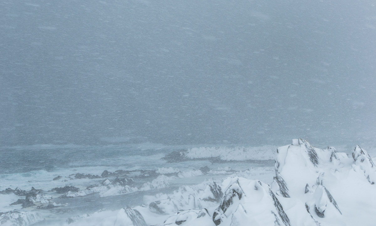
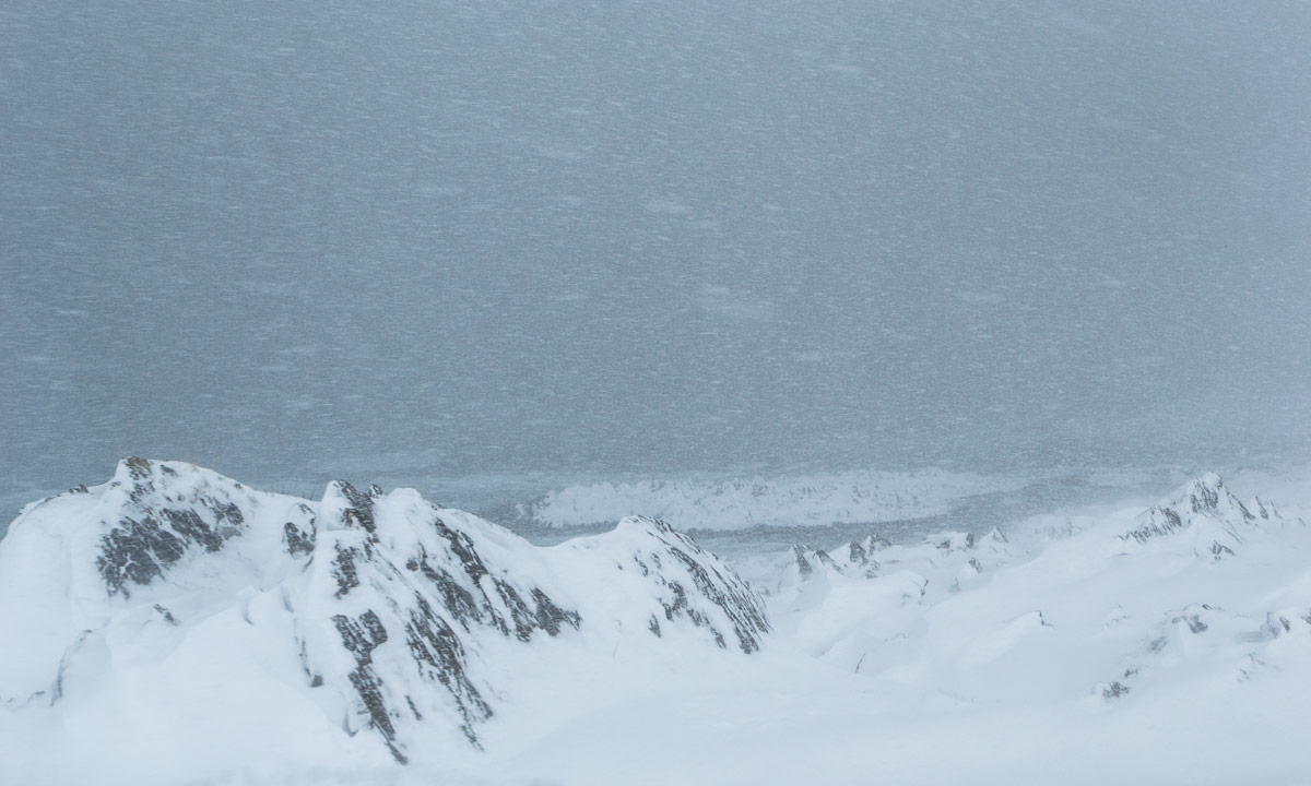
This morning was even warmer with only -8 °C and quite foggy. Both wide angle lenses were completely fogged and it would take most of the day until I could make clear photos again. That’s what the morning  looked like:

As usual we took it easy and started only at 11 o’clock. We descended through the hilly open woodland until we met the winter trail. Snowmobiles had used this trail not long ago and now it was quite easy – even if a bit boring – to get ahead. And after some time even the sun tried to twinkle between the clouds. The first time after many cloudy days we casted shadows again. And it was snowing at the same time.

I skied fast on the snowmobile trail where I could use cross country skiing techniques. Too fast for Jonas and too fast for myself, too. I couldn’t hold the tempo and after some time I was really exhausted – not for the first time on this tour. On the other side it was already afternoon and we were already quite near Kvikkjokk, where I had parked the car. Jonas found a nice clearing in the forest were we tented the last time on this tour. And even the sky cleared up a bit.

Thursday, 15 February

We do not know if we missed northern lights while we slept. The morning however the sky was grey and overcast again and half a centimetre of dust-like snow covered the tent. (And my green anorak that I had forgot to put into the pulka.) Today we would have it easy. Just some kilometres skiing on the winter trail that means, following the snowmobile tracks, mostly on the river.

We passed the place where we had left the very same river the very first afternoon to find our tenting place. Here, in the “valley” much less snow had fallen and our deep tracks climbing up the steep riverside were still visible. Now it wasn’t long to the private shortcut that we had used on our tour start. When we came to this place, a snowmobile approached from that very shortcut, a man waved at us and made a turn to talk to us. It was Björn, the very same local that we met when we started our tour! He was quite eager to hear about our experiences even though he was a bit in a hurry. He also told us about two other Germans that he just had met at the very same parking place where I had parked my car.

The last kilometres, crossing a small frozen river …

… following the shortcut (which is quite long for being a shortcut) and finally we arrived at the parking place. We hadn’t much luck with the weather, we didn’t ski long distances, but it was an awesome tour anyway. Thank you, Jonas!

Plans for the next ski tour:

  • be better trained and exercised (!!!)
  • have less equipment (!!)
  • have (partly) better equipment (!)

Photo #6 and #9 in this blog article are made by Jonas Balbasus.

At the parking place we met Dan and Helen, also from Germany, who just were on the point of starting a much longer tour within less than two weeks: Following the Padjelanta, crossing the Sarek, returning on the Kungsleden. A very ambitious tour in my opinion. But they made it as you can read in Helen’s blog:
Winter ski tour through Sarek National Park – Sápmi / Swedish Lapland


Båtsfjord – Ørnes by Hurtigruten

This article is part of the series “2018-03: Varanger peninsula”.

Days 41 to 44 of my winter journey 2018

13 March at 19:45 the Hurtigruten ship MS Nordnorge docked in Båtsfjord. Annika went on board with all our luggage that we would need the next days, while I drove the car into the elevator. The next 59 hours we would travel many miles but stay in the same cabin. Cabin number 305. Kind of luxury. We would even get breakfast because of a campaign. On 16 March round 7:00 we would leave the ship in Ørnes and drive home.

I will not write much about this part of the winter journey but showing photos from the Hurtigruten trip with some comments.

13 March 20:30 – finally on the Hurtigruten. Shop, reception, restaurant and people cruising.

13 March 22:00 Berlevåg – the westernmost of the four Hurtigruten stops Vadsø, Vardø, Båtsfjord and Berlevåg. Some days ago we stood on the breakwater to see the ships coming in, now I stand outside on the bow of the ship to see the very same breakwater passing as we approached the peer.

14 March 05:25 – very early and quite cold in the wind. I’m the only one outside beside of people working.

14 March 05:40 – approaching Honningsvåg on the island Magerøya. Main attraction of that island: the North Cape.

14 March 06:35 – I stay outside and look at the constantly changing weather.

14 March 08:25 – two ships pass. First a smaller boat, twenty minutes later the Hurtigruten ship Kong Harald. It’s snowing.

14 March 11:15 – we approach Hammerfest. Normally the ship will lie there for two hours, but today the ship is late.

14 March 15:45 – I’m outside for some hours and enjoy the view at the landscape. Everything is constantly changing: The mountains, the perspective, the light.

14 March 20:15 – strong polar lights cover the sky. Many people are outside and so are we. I already showed some photos in the article Aurora on the Hurtigruten.

14 March 23:45 – we approach Tromsø. Annika and I are already in our cabin and ready for sleep, but I can see the Tromsø Cathedral through our porthole. (We booked a cabin with limited view to save money and our porthole is more like a tube.)

15 March 07:30 – it’s not cold but very windy on the bow of the ship. My advise for such a winter journey: take the warmest jacket you have.

15 March 07:35 – we approach Harstad.

15 March 10:20 – we reach Risøyrenna – the Risøy Channel, build between 1911 and 1922 to enable bigger ships pass between the islands Andøya and Hinnøya. Only seven meters deep.

15 March 17:00 – we approach the quite famous Trollfjord. In winter however the Hurtigruten ships do not enter it.

15 March 18:30 – we arrive in Svolvær, largest town on the Lofoten. It’s a longer stop and Annika and I leave the boat for looking around.

16 March 06:00 – the alarm clock rings. At 7 o’clock we will arrive in Ørnes, leave the ferry and drive to Skelleftehamn. 583 km by car then I’ll be home again after more than six weeks of travelling.

A day in Båtsfjord

This article is part of the series “2018-03: Varanger peninsula”.

Day 41 of my winter journey 2018

After a difficult car ride over through gale and snow Annika and I arrived in Båtsfjord, where we stayed overnight.

As usual I woke up early. I got out of bed and took a first look at this town. Although a lot of snow had come the day before all roads and streets were already cleared. Some houses and fences however were still snowed in. Perhaps the houses were not in use or the owner was travelling, too.

And here a look at one of the harbours.

After breakfast Annika and I got a guided tour through Båtsfjord by our landlord. He comes from Finland and came to this town in 1999. He showed us round and told us a lot about this town whose main economical sector still is fishing. The fishing port is one of the biggest in the Finnmark with around 10000 boat arrivals per year.

He drove us to a place at the harbour where you can watch two species: (1) the king eider, a large sea duck and (2) the bird-watcher, a subspecies of the human being. Four of these bird-watchers lay in a huge box in the water and were spotting the king eiders. Mostly you couldn’t see the bird-watchers themselves but only their huge tele lenses.

Thank you, landlord from Finland whose name I forgot for this interesting guided tour!

Some other images of Båtsfjord I made over the day:

Later that day we sat in the waiting room and waited for the Hurtigruten to come. Our two-week stay on the Varanger Peninsula would end today and we slowly would travel home again. But instead of directly heading home by car (943 km) we would take the Hurtigruten ship to Ørnes and drive home there. Well, that spares us only 360 km and takes almost 60 hours, but it’s nice to travel by Hurtigruten, especially after visiting so many different places by car.

At 19:45 the Hurtigruten ship MS Nordnorge arrived and the next stage of the journey began.


Why travelling in Northern Norway can take time

This article is part of the series “2018-03: Varanger peninsula”.

Day 40 of my winter journey 2018

At 11 o’clock we left Kjølnes Fyr and started our car trip to Båtsfjord. First we had to take the road 890 to Kongsfjord and over the Kongsfjordfjellet, then we had to continue on road 891 over the Båtsfjordfjellet to Båtsfjord.

I wasn’t sure if we would manage it due to the severe stormy and snowy weather. Another guest staying at Kjølnes Fyr had a hard time driving the 5 km from Berlevåg with very bad visibility. The roads however were still open though marked with a warning “difficult driving conditions because of snowstorm”.

And yes, it was stormy and it snowed a lot. The sight on the road however was still quite good. While I focussed on the road Annika took some photos of the coast beside of the road:

Some parts however were very hard to drive, since the visibility was extremely bad. It was hard to see whether there were snowdrifts on the road and how deep they were and several times I had to stop completely to find out, where the road continued.

I started to doubt if it was possible to cross the mountain passages but we would make it at least to Kongsfjord where we could stay overnight if continuing became impossible. Annika tried to check the traffic information of Vegvesen – the Norwegian Public Roads Administration – but there was no mobile internet available.

I continued driving along the E 890 and the only other vehicle we met was a snow plough. The street behind it however seemed as snowy as before.

Shortly before Kongsfjord Annika’s smartphone was online again and she informed me about the updated traffic information: The mountain sections of both the 890 and the 891 where restricted to kolonnekjøring which means that you cannot drive alone but have to follow a convoy guided by a snowplough. The kolonnekjøring was scheduled to 14:30. The good thing: Driving in a convoy would be much easier than driving alone.

When we arrived in Kongsfjord it was 12:10, so the 28 km drive from Kjølnes Fyr had taken more than an hour. We were lucky that there is a landhandel – a grocery – in Kungsfjord that is open all year. We entered the landhandel, told about the kolonnekjøring and were invited to coffee and cookies straightaway. A big thank you to the owner for the warm welcome!

While we sipped our coffee and waited we constantly checked the traffic informations. After a short while we learned that the start of the kolonnekjøring was postponed to 17:00. That meant more waiting, but we were not the only ones. Other men in work clothes – mostly fishermen – waited as well. They told stories, laughed out loudly while drinking coffee or eating fast food. Anyway we all were still lucky. While we only had to wait some more hours many other roads were completely closed due to the weather, among others the way to Mehamn, the passage between Kiberg and Vardø and the only way to the North Cape.

Hours later: We said goodbye, cleared the car of snow and drove the short way to the boom gate. Here some other vehicles, mostly trucks waited for the convoy to start. One of the truck drivers attached snow chains to his truck.

Dusk had already been falling when our convoy started some minutes after 5 o’clock. My job for the next time was following the rear lights of the car in front.

Some passages were quite easy to drive, some passages were hard to follow due to the blowing and driving snow. (Sorry, no photos.) After 35 minutes we arrived at the T-junction, where the 890 from Kongsfjord, the 890 from Tana Bru in the south and the 891 from Båtsfjord meet. A long queue of cars coming from Tana Bru already waited. Some minutes later the convoy from Båtsfjord arrived as well. The snowplough leading the convoy to Kongsfjord passed and seconds later our queue of cars started to approach the intersection were we turned left to follow the convoy to Båtsfjord.

This part of the trip was extremely exhausting. It was dark, the convoy was slow and mostly the visibility was really bad. I just tried to follow the red lights in front and it felt like hours and hours until the snowplough turned right and we suddenly arrived in Båtsfjord. Here it seemed to snow as much as in the mountains and I was very relieved when I finally parked the car at our overnight stay. Phew – that was no easy ride and I’m really grateful that convoys led us over the mountains under the snowstorm conditions.

The rest of the day? Buying foodstuff at REMA 1000, eating fast food, falling asleep quite fast while the snow squalls over Båtsfjord continued. According to our host 30 cm of snow already had fallen that day and more was expected.

At least we arrived in Båtsfjord, probably our last overnight stay on land. The next evening we would take the Hurtigruten to Ørnes, were we would drive home to Skelleftehamn and Umeå.

(The first five photos were shot by Annika. I did the editing.)

Kjølnes Fyr

This article is part of the series “2018-03: Varanger peninsula”.

Days 38 to 40 of my winter journey 2018

Saturday

After our stopover in Kongsfjord we continued the road 890 in direction Berlevåg. The road follows the coastal line of first the fjord Kongsfjorden and then the open Barents Sea. Our destination for today is Kjølnes Fyr where we planned to stay over for one or two nights.

Kjølnes Fyr is located on a small headland called Kjølneset 5 km east from Berlevåg. We had booked a two-bed room at this place because it looked more interesting than the “large” city Berlevåg with its round thousand inhabitants. At half past one we arrived.

I directly fell in love with this place. The lighthouse – some other houses around – a rugged rocky coast, partly covered with snow, partly with seaweed – to the west bare mountains and to all other sides the open Barents Sea.

If you started a boat trip from Kjølnes Fyr heading north, the next land you would approach would be Kongsøya, part of Svalbard.

Viggo who operates the lodging gave us the key to the lighthouse and we took a closer look. The original lighthouse from 1916 was destroyed in World War II, the new lighthouse was built in 1949 and has a very functional and sober appearance. We went up and looked over the Barents Sea watching the high waves breaking at the rocky shore.

Viggo and his wife moved to Kjølnes Fyr in last autumn. He has rented the houses, that are protected as a historic monument. He told us from a winter storm that he experienced in January. Wind speed was up to 70 m/s (~250 km/h) and the upper floor of their house was shaken so violently, that the vibrations moved around the furnitures inside. Compared to that experience we had it quite calm.

The only thing we made over daytime was driving to Berlevåg to buy food. In Norway almost all shops are closed on Sundays and there were things we needed (spaghetti …) and things we wanted (chocolate …).

Later that evening we drove to Berlevåg again to see the Hurtigruten ships coming in.

Sunday

Under the night the wind got a bit stronger and the waves approaching from the north had become higher. Annika and I took a really lazy day. I was outside several times, but only for taking photos of waves. They never broke at the same place twice and gave me a hard time making pictures.

Weather became worse the whole day: The wind increased more and more and it started to snow, which means that snow was thrown into my face vertically when I dared to look into the wind. When it started to get dark, the ice and snow covered rocks in the cold light of the blue hour made the landscape look as what is actually is: arctic.

Already in the afternoon the Norwegian Meteorologisk institute had issued a class one wind warning for the whole area. I started to get a bit nervous. The next day we wanted to continue to Båtsfjord, our last stay on our Varanger trip but I was not sure whether the weather would allow it. Anyway, all roads were still open.

Monday

It had snowed a lot in the night and still was snowing heavily. Due to the stormy wind parts of the ground were completely bare of snow while other parts were covered with knee deep snow. At the same time it was quite warm, hardly below zero. The weather warning was extended to the afternoon but wind should decrease a bit over the day, so we planned to start round 12 o’clock. I was out and took some more photos, but it was really rough weather, especially for the camera.

Right after breakfast Viggo got a call of another guest approaching from Berlevåg by car. She couldn’t find the departure to Kjølnes Fyr due to severe weather conditions and asked for help. He took the car and drove to the main road just to mark the departure visually. When she came in she looked quite exhausted from the short car trip. She advised us not to continue the trip that day and told us, that visibility was partly only 10 meters which would make it impossible to see the next way mark.

We waited some time but despite of the stormy wind the visibility looked really good. Therefore we decided to give it a try and drive at least to Kongsfjord, that we passed two days ago. Here we could either continue our trip or take a room and stay in Kongsfjord overnight.

So we packed the car, said goodbye, removed the snow from the car and started our car trip to Båtsfjord at 11 o’clock.


Over the kalfjell to Berlevåg

This article is part of the series “2018-03: Varanger peninsula”.

Day 38 of my winter journey 2018

The Varanger Peninsula has many inhabited places at the coast, but you cannot take the car and drive around the whole island, not even in summer. There are three roads:

  • The E 75 to Vardø via Vadsø. In summer you can continue to Hamningberg, but this place has been depopulated since 1964 though some houses are used as summer cottages.
  • The 890 to Berlevåg via Kongsfjord. In summer you can continue to Store Molvik, but there are only summer cottages.
  • The 890 and 891 to Båtsfjord.

We explored the towns connected by the E 75 so far. Yesterday however we left the Varanger Peninsula, visited the Sea Sami Collections in Byluft and spent the night in Seida near Tana. Today we continued our trip and entered the Varanger Peninsula again, this time using the 890 to Berlevåg.

A local in Ekkerøy had warned us about this road, which leads about the kalfjell – the bare mountains above the treeline. The weather conditions can be severe and the road can be closed anytime due to bad weather or only accessible by kolonnekjøring, which means that you drive in a guided convoy led by a snowplough. Mostly it’s not snow that is the problem, but strong winds, that can create impassable snowdrifts within minutes.

The weather today however was fine and we didn’t have any difficulties in crossing the kalfjell. The road is really exposed to the elements and I can imagine that the very same road will be completely impassable in stormy conditions.

There is however another possibility to travel from one place to another: using the Hurtigruten ships, that connect Berlevåg, Båtsfjord, Vardø and Vadsø on their way from Bergen to Kirkenes.

A skitour near Ekkerøy

This article is part of the series “2018-03: Varanger peninsula”.

Day 36 of my winter journey 2018

locking the rented house in Ekkerøy – taking by car to the main road – looking for a parking place – mounting the skis – following the snowmobile trail – leaving that trail – slowly ascending the hill – leaving the last willow bushes behind – skiing – breathing – viewing – enjoying Varanger’s “kalfjell” above the treeline.

A tour to the easternmost point of mainland Norway

This article is part of the series “2018-03: Varanger peninsula”.

Day 29 and 30 of my winter journey 2018

Yesterday we continued our journey to Ytre Kiberg which is 13 south of Vardø, one of the Hurtigruten stops. We started in Vadsø – another Hurtigruten stop – after a breakfast with our host Nils, bought a basis of food for the next days and took the E75 northwards. We made a stopover in Ekkerøy, a village on a peninsula near Vadsø. We like this place and will try to stay there for some nights next week.

At lunchtime we reached Cape East Arctic Adventure, our stay for four nights. We were welcomed by Trond, the owner and operator of Cape East Arctic Adventure and were shown our cozy bedroom, the kitchen and the homely living room. After making ourselves at home we went along the beach to the village and the harbour.

In the evening we were invited to a three course dinner based on freshly caught cod: Fish soup – cod with potatoes and carrots and finally cod roe. Everything was extremely tasty and it was Annika’s and my first time where we tasted cod roe. Yummy!

In Kiberg you are as east as you can be in the Central European Timezone, therefore sun is rising already at 6:24. I was awake very early and took a morning walk round 6 o’clock. Some snow drifts had been created by snow and wind over night but now the weather was less windy and quite sunny. At least for a short time. While I went the way to Indre Kiberg clouds approached, wind increased and it started to snow. It was hardly imaginable that it was sunny just a short time before. Weather changes here quite often as Annika and I should find out later.

After breakfast Annika and I took the car to the other side of the village, put on our snow shoes and started a hike to Kibergsneset, easternmost point of mainland Norway. This place is more east than e.g. St. Petersburg, Kairo or Istanbul! It was windy but quite sunny, when we started our tour but weather changes fast on the Varanger Peninsula:

Actually this hike is just a promenade but the weather may transform it into a small expedition. We were exposed to wind and snow and grateful, that we didn’t experienced a full storm. The weather was rough anyway and I was glad about my windproof jacket and two pairs of mittens.

We continued on a small hiking trail, first with, then without snowshoes because the thin snow layer was hardened by the wind and easy to walk onto. There’s a coastal fortress build by Germans in WW2 on Kibergsneset but we couldn’t see it in the snow weather. Instead of looking for it we continued to the small lighthouse at Kibergsneset that marks the easternmost point of mainland Norway (and most of Europe). Shortly before we reached it the sun came out and we continued the last metres in full sun. While I made some photos a small snow shower approached with the sun still shining.

From the lighthouse there was an amazing view over the arctic coast of the Barents Sea, but only for some moments. Soon the next snow shower came by and hid most of the view onto both the coast and the sea.

The way back was much shorter because we knew the way and went downwards. Even though the view was limited by the snow showers Ytre Kiberg came into view again soon and surprisingly the weather was nice and sunny again.

After this very windy promenade we were glad to find shelter in my car. We took the car to Vardø to eat something and after that we tried the road to Hamningberg. We knew that the road was closed in winter but we curious how long we would come.

Well, not very long. We managed to get to Smelror, some kilometres north from Vardø.

The main road however was definitely closed as you can see. There are no people living in Hamningberg permanently and the only motorised way to reach it in wintertime is by snowmobile. For car it is open less than half the year.

We took the car back to Kiberg, enjoyed the incredible and unbelievable colours of the sky and were surprised by a strange weather phenomenon: -6 °C and rain (including a faint rainbow!)

The rest of the day? -10 °C and wind outside, no more photos, no more excursions.

Fun fact: We took the E75 northwards. If you would take it southwards you could travel more than 4000 km and finally would arrive on Crete, Greece.

A snowshoe promenade

Day 27 of my winter journey 2018

Today our current host Chris took half a day off and we (Chris, Annika, I and two dogs) made a trip into the valley Pasvikdalen. There’s a small place called Strand where we parked our cars at the former boarding school, nowadays a museum. Here we started a small small snowshoe tour up the Brattberget.

Brattberget means the “steep mountain” but first of all the mountain is more like a hill and then the way up is not steep as all. First we went through denser forest, then then forest and the view opened a bit. Soon we were up on the top of the hill.

There’s a toilet and two benches on the Brattberget. While the benches were covered with snow, the toilet was still visible.

The weather was nice and we had a great view. To the north and west of the lake LangfjordvatnetUhcavuonjávri, to the south, remote in the distance of Russia.

After a short rest in the sun and some photos we descended the same way we went up and soon were at our parked cars again. A short and nice snowshoe tour through the hilly and wintry Pasvikdalen.

A ski tour in the Kvikkjokk mountains – day 5 and 6

This article is part of the series “2018-02: Ski tour near Kvikkjokk”.

Day 11 and 12 of my winter journey 2018

After our second night in the tent (it was 20 °C warmer than the first night) I woke up at 7 o’clock. My thick isolated sleeping bag was much too warm and I was glad to get out of “bed”. Time for some photos of our tent and the surroundings.

Today we wanted to leave the trees behind and ascend to the kalfjäll – the treeless mountains region. Since we already were level with the treeline we soon came to the place where you hardly see anything more than snow, some rocks and the winter waymarks.

Jonas is interested in many things, among others bouldering. When we came to a nice large boulder after some hours of skiing, he took the opportunity for a (very) short bouldering session. Here’s the evidence photo:

After that short break we continued our tour over the kalfjäll. It snowed and it was quite windy. The boulder was quite near to the mountain shelter Kurajaure, where we arrived half an hour later.

The wind had grown stronger and stronger and we were glad to enter the shelter. We took the pulkas in, too. These mountain shelters aren’t made for overnight stays beside of emergency situations. We however decided to stay in this shelter anyway for some reasons I won’t reveal here.

Of course we didn’t use the woodstove and firewood. We took our own paraffin stove, prepared food and slept in our sleeping bags, since unheated the shelter was as cold outside as it was inside. But there was a big difference: We were protected against the strong snowfall and the rough winds. I went outside anyway to take some photos in the dusk.

This time we did something new: we set the alarm clock for the next day. We wanted to reach the mountain hut Tarrekaisestugan which we passed two days before and suspected that we had to ski through a lot of fresh snow against rough headwinds and strong snowfall. Since we didn’t know how much time it would take we had set the alarm clock to 7 o’clock. The plan was to leave 8:30, but it became 9:20 when we started our 6th tour day.

It was -12 °C and quite stormy. I guess the windchill was round -30 C. I closed my fur trimmed hood as much as possible and later I took even a buff over mouth and nose to protect against the icy snow that the wind threw into my face. I used three pairs of gloves and mittens – one over the others – to protect hands and fingers. Here’s a selfie of me (left) and Jonas (right) made on the kalfjäll.

There was a lot of new snow, probably 10 to 15 cm. All snowmobile tracks (and our own from the day before) had disappeared. We returned the very same way that we went the day before. Although weather was rough, skiing was easier than expected, because we went more down- than uphills. The steep part however was a real disappointment. This stage had costed a lot of efforts to climb the day before, now it took less than ten minutes to ski down. After a passage over the frozen lake Tarrekaisestugan came into view.

It took more time than expected to cross the lake, but the most exhausting part was the slope by the lake that we had to climb up to reach the mountain hut. Here at least 30 cm of fresh snow had been falling and even the deepest snowmobile tracks were hardly visible. After we arrived and removed our skis I removed ice from the outside of the window. I had to plunge through hip deep snow to reach it. The snow depth behind the hut was at least two meters.

After two cold nights we were glad to dry both sleeping bags and clothes and hung up mittens, jackets, boots, caps and much more and to heat the woodstove.

Our dinner: couscous with roasted salami, dried tomatoes and ready-made champignon sauce. Tasty!

The two photos showing me on skis are made of Jonas Balbasus.