A trip to Murmansk with Barents Press

This article is part of the series “2019-03: Redex Murmansk”.

Last year a friend of mine told me he would travel to Murmansk and asked me if I wanted to follow. The friend finally did not have the time, bit I got the opportunity of a Murmansk trip thanks to Barents Press, a journalist network in the Barents Region. I became a member as a photographer this year.

The project called Redex 2019 has a strong focus on sport journalism and sport events in Murmansk. People who know me may know that I do not care about sport competitions. In this case however there’s a large sport event I’m interested in: the 3rd Ice Swimming World Championship. I’m very glad that I was invited to travel and my thanks go to Barents Press for the invitation, for taking all the costs and for the great organisation.

Monday 11 March, 7:00. I just finished my breakfast in a hotel in the Comfort Hotel Arctic in Luleå and we are ready to travel to Murmansk. We, that is five journalists, me, and Sergei, our Russian chauffeur. He came from Murmansk with a Mercedes 15 seater minibus the day before. Good to have a bit of comfort, for we will travel about 840 km which will take the whole day.

Off we go. To Finland it’s only 130 km.

And – swoosh, are we in Finland. You hardly realise that you just crossed a border.

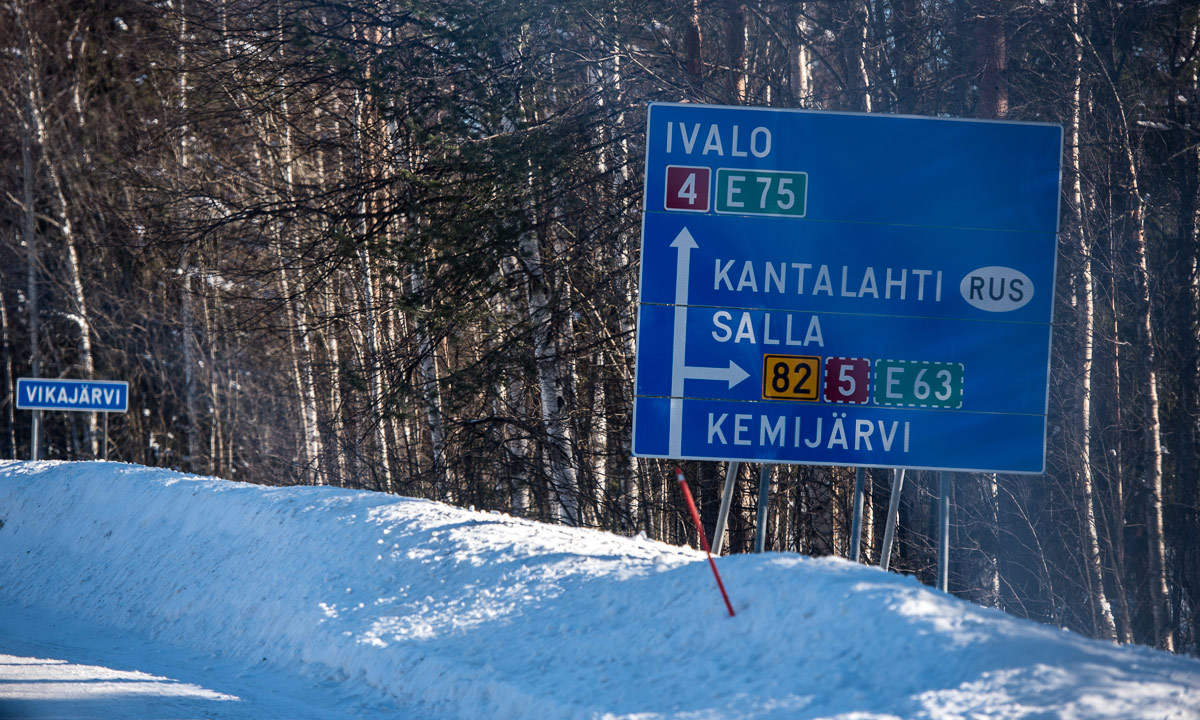
There are different ways to Murmansk. We will take the way via Salla. We make a lunch break in Kemijärvi where we got an extraordinary delicious lunch at Mestarin Kievari with a lot of salat and side dishes and even two different desserts.

At 15:30 Finish time (1 hour ahead) we arrive at the Finnish side of the Finnish-Russian border. Sergei has to make some paperwork and we have to wait, then we all show our passports before we enter the bus again to drive to the near Russian border.

The first check is before we exit the bus: A Russian official gets on the bus, counts us and checks our visas. Then we drive to the custom office where we leave the bus and have to fill out a form, that we have to keep with our passport the whole stay in Russia. It takes some time to fill the form, especially since it’s so tiny.

Then we go through the control, one by one. I’m first. There’s a minor problem with my form but Tim who speaks Russian can help. I wait on the other side where there’s a small exhibition of war memorials found at the border. I say one of the few sentences I know in Russian: Можно фотографировать? Yes, I may take pictures.

Then we are i Russia. Another check of the officials, that we are complete and have our stamps on the forms and in the passports. 20 other km and we have travelled half the distance. The Russian roads and landscapes are very similar to the Finish ones. It’s not easy to take landscape photographs from a bus driving on a bumpy road with a lot of windows reflecting the light. I start to doze.

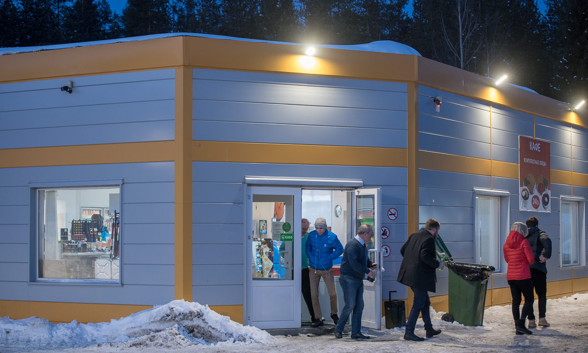
We stop in Алакуртти/Alakurtti to refuel the bus. We have to wait, because the gas station itself is being refuelled and that takes some time. Anyway it feels good to stretch my legs and to get some fresh air.

After half an hour we continue our trip. We make a short stopover at a petrol station in Кандалакша/Kandalaksha, then we drive on.

It starts getting dark and I try to sleep a bit. It’s still 250 km to Murmansk and our trip takes some more hours, but finally we approach the city.

On the sign stands: “Murmansk, Hero City”, an honorary title from the Soviet times for outstanding heroism during WWII.

Just before 22:00 local time (+ 2 hours) i enter room 838 at the Park Inn Hotel, where I’ll stay the next five nights. So the whole ride took almost 13 hours and I’m really tired. But before going to bed we meet at the lobby and go to a restaurant nearby to get a late dinner. (I remember the food was tasty, but I’m not sure because my brain already had turned on the autopilot.)

The whole route: LuleåHaparanda/TornioRovaniemiKemijärviSallaКандалакша/KandalakshaМурманск/Murmansk.

Skiing from Syter Fjällstuga to Umasjö

This article is part of the series “2019-03: Ski tour Vindelfjällen”.

Wednesday, 6 March

Today we will have the longest distance of our ski tour: round 22 km from the Syter Mountain Cabin to Umasjö. We get up at 5:45 and start our tour at 7:30 to have enough time before sunset.

G., the stugvärd recommended to go on the small river Voehpejoeke or Svärfarbäcken, it would be easier to ski. We however do not dare and follow the marked winter trail. That turns out to be a quite bad idea. The trail seems to connect all existing hilltops around. The hilltops are exposed to the wind so that they are free of snow. There is vegetation, rocks and a lot of bare ice where neither the skis nor the poles get any hold. We barely make any progress and our frustration grows. After a while we decide to follow G.’s advice and ski down to the winding river.

You have to know, that there is ice and water under your feet for all we can see is snow, a bit of vegetation and some rocks. We feel safe and we are at least three times faster than before. After some time we come to a wide plain where I make the first tour photo of the day.

The morning had been cold again with temperatures below -20 °C, but it quickly became warmer and clouds have approached, covering the mountain peaks. Despite to the forecasts it is windy and the drifting snow makes the view hazy.

After 5 km we pass a Sámi dwelling, marked in the map as a black triangle.

Then we approach a narrow passage and the frontal wind increases. First I think it is snowing but it’s just the snow driven by the wind. We avoid making smaller breaks because there is no shelter in the valley and we would have to put on down jackets to avoid hypothermia.

The way is long but navigation is easy. We just have to follow the red crosses. Visibility is not the best but still we can see at least the next three or four crosses. After the valley we have to ascent a pass but the ascent is so slow that we hardly realise, that it’s already the pass. I check our position with the GPS but take the wrong number. I know that it has to be wrong but we continue anyway. What shall happen: we are on the trail and it feels like we are in time. It was only the first stage that slowed us down.

Even though the way is long it is a great tour. Snowmobiles are prohibited and we ski through the untouched snow landscape, completely alone. I do not take many pictures because I don’t want to loose too much time.

It’s still windy. When Annika goes ahead parts of her ski tracks are snow covered after already half a minute. At least it’s not cold, probably between -5 °C and -10 °C.

I check the GPS again, this time more properly. We have come further than expected and are faster than thought. Sometimes we stop to drink a bit and eat chocolate (mostly me) but we try to minimise the breaks.

We are on a plateau now, where the wind is calmer and it’s easy to ski. But we know that we have to descend 300 – 400 metres. And soon we have to ski downhills which is not our most outstanding skill. At least the slopes are wide and there are no trees around.

The trees appear a bit later but still it’s easy to ski. And then we finally meet the first snowmobile trail. It is descending through the forest but it’s so wide that it’s easy to ski down, either directly on the tracks or on the sides through untouched snow. Then we come to the “snowmobile main road”. The signpost says, that 17 km lie behind us and 5 other km to go.

This part is both boring and tiring. The track goes up and down which doesn’t matter for snowmobile drivers but for us. We curse every hill we have to ski up.

But finally we reach our final destination of today’s ski tour. The road E12 in Umasjö.

Our four-day ski tour is over but neither the journey nor the day.

Annika’s colleague F. is staying on her mountain cottage in Umasjö. It is she who comes shortly after our arrival and gives us a lift to Hemavan, where I parked my car three days ago. We buy some food and drink (rich in calories!) and drive back to Umasjö where we meet F. again in her cottage together with her family. We sit in the living room and report from our ski tour. After that we continue our journey to Norway, where we visit friends of Annika in Mo I Rana. The road conditions are not the best and I’m tired but luckily it’s only a one-hour drive from Umasjö.

That has been a long day and an exhausting one as well, but – more important – a great one. Now I’m looking forward to the next ski tour together with Annika.

Skiing from Hemavan to the Viterskalet Fjällstuga

This article is part of the series “2019-03: Ski tour Vindelfjällen”.

Sunday, 3 March

A perfect day for a ski tour awaits us when Annika and I wake up in Hemavan, where we arrived the evening before. The ski is blue, the air is calm and the outside thermometer at Hemavans Fjällcenter shows -23 °C.

Today Annika and I will start our first ski tour together. We are going to be in the Vindelfjällen mountains for four days and stay overnight in two mountain cabins of the Swedish tourist association: Viterskalet and Syter. Annika is going to use a backpack and I a pulka sledge. Hopefully Annika’s backpack will hold, she already had to fix a friable strap the day before. After a breakfast we take my car and drive up the slope to park it near the Kungsleden sign.

Here the Northern Kungsleden starts, Sweden’s most popular hiking trail which is 450 km in total. We will follow the Kungsleden for two days and then turn west to Umasjö or south to Solberg back to civilisation.

At half past nine we are ready to start the tour. An employee of the ski area takes some pictures of us, wishes us a good tour, sits down on his snowmobile and drives away.

Now we have to climb up the ski slope, luckily not directly. Anyway we have climbing skins under our skis that prevent slipping back when ascending slopes. It’s no fun at all to use a pulka without them. We ski on broad prepared ski trails. It doesn’t take long and the fixed strap of Annika’s backpack breaks again. At the small hut of a ski lift she replaces it provisionally by another strap. Luckily this makeshift solution will work for the rest of the tour.

Although the sport holidays started the day before the ski resort is anything but crowded. When we however leave the ski resort behind us we are really alone for a while. Only another pair of skiers faster than us overtakes us at the steepest slope of the day. We are above the tree line. Only some solitary birch trees interrupt the snowy kalfjäll.

After a while we meet the snowmobile track. This track is quite popular because the Viterskalet cabin serves waffles – a welcome destination for snowmobile enthusiasts. For us as skiers it is a bit boring to walk on a five to ten meter broad “snowmobile Autobahn” and the exhaust fumes of the less modern snöskoter stink terribly.

We pass the summer bridge over the Västra Syterbäcken. Here’s even a toilet in the middle of the snow covered mountains. Only four other kilometres to go.

The whole winter trail is marked with red wooden crosses and there are many of them. In nice weather this seems a bit overdone but all people who followed such a winter trail in snow storm know that it can be very hard to find the next mark even when it is near.

Another hour of skiing and we arrive at the Viterskalet cabin. The stugvärd who is responsible for the mountain cabin greets us. There are two larger buildings: The cabin of the stugvärd with shop and even a small café and the guest cottage. The shop is tiny but has everything you need. Therefore we can buy most food in the shops and do not need to bear everything for four days.

We allow ourselves the luxury of a cold coke and a waffle. Then we move into the guest cottage. It is huge and hasn’t been heated for a while. Our sleeping room is heated by gas and temperature is at least over 10 °C but the huge kitchen has only 1 °C and it will take hours to warm it up some centigrades. The other guests have left. We will be the only ones to stay overnight.

I stroll around and take photos while the sun is slowly going down.

Annika and I still have garlic bread bought in Hamavan and eat it with a goulash soup bought in the shop. It doesn’t take long and we cuddle ourselves in our sleeping bags. Soon we fall asleep. Mountain air makes you tired!

I however have to pee in the night. For that I have to go outside. That means putting on boots, mittens and a down parka, because it’s -20 °C. This seems to be very uncomfortable but it has its advantages. I can watch an incredible starry night in the Swedish mountains. It is so bright and clear that it only takes seconds to spot the milky way. I just have to go in to fetch my camera and tripod. The green lights over the horizon is a Northern light, but a very weak one.

Travelling to Bjørnevatn

This article is part of the series “2019-02: Northern Norway”.

After visiting me home in Skelleftehamn Chris and I continued to Jokkmokk on Thursday. We visited the winter market and then drove to Solberget, where we stayed overnight.

The next day we started a long drive with her car. Chris lives in Bjørnevatn near Kirkenes and we planned to arrive there the very same day. At 7:10 we started our journey that would lead us through Sweden, Finland and Norway.

First the sky was cloudy but the visibility was good. Then it started to get a bit foggy.

Normally that’s no problem. This icy fog however started to cover the windscreen more and more and we had to stop often to scrape of the ice.

In Gällivare we stopped at the gas station and had some breakfast. We also bought a bottle with de-icer for the windscreen and continued our trip.

The de-icer didn’t help, we had to stop many times to scrape away the ice from the freezing fog. We were not the only ones. The headlights and the number plate were covered with several millimetres of ice, too. I never had experiences something like this before.

Only the bottom 15 cm of the windscreen were free of ice. While Chris crouched into the seat to be able to see I gave up taking pictures from the road and photographed sideways.

We approached the Swedish town Karesuando. This small town is located directly on the Muonio älv, which also forms a natural border with Finland. On the other side the town is named Karesuvanto where we took another break.

Strangely the ice problems stopped right after the Finnish border. We continued to Palojoensuu without any problems. There we turned left onto the road 93. An hour later we were at the Norwegian border.

After being stopped by the customs and assuring them that we have neither alcohol nor cigarettes with us, we continued driving through the snowy plains. Next stop: Kautokeino, where most inhabitants are Sámi. Here we ate a hamburger with chips, a typical meal if you travel through Northern Norway.

Until now, Chris had driven a car. Now it was my turn to drive to give her at least a short rest. The first time I drove a diesel.

Round two hours later we arrived in Karasjok. What I already had suspected, confirmed here: It was cold outside: -30 °C.  Time for another break.

Back in the car, Chris was driving again. It was dark, it was cold, we were tired and still more than four hours to go.

I started to get bored and played around with my camera.

A pale green stripe appeared above the street. A northern light. The next hour we got quite nice northern lights, mostly directly in front of us. Though being tired we got at least entertainment. The photos are awful, northern lights are not made for being photographed free-handed from a car on a bumpy road.

Finally we came to Tana, where we crossed the river of the same name. A quarter hour later we arrived in the small town Varangerbotn, were we took the last stop of our long trip.

Now we drove along the fjord Varangerfjorden. Anyway, beside of some street lights and the weakened aurora it was pitch black and I couldn’t see the fjord. Beside of that I just longed for a bed.

But finally we arrived at Chris’ home in Berg near Bjørnevatn. Arrival time 23:40, 16½ hours after we started in Solberget.

Here I’ll spend the next days.

Link to the route on Google Maps


The ice road in Avan

Today I had a meeting in Norrbotten, Sweden’s northernmost län (county). It was the annual general meeting of Barents Press International, a joint network of journalists in the Barents Region. I joined this organisation a few weeks ago and took the meeting as an opportunity to meet members of Barents Press in real live.

The projects presented at the meeting were really impressing. In addition to that the people were both very friendly and extremely interesting.

The meeting was in Avan near Luleå, 150 km from here or as the Swedes say: 15 miles. The name Avan rang a bell, but it took a look on the map to remember that it’s the place where Annika and I had used the ferry to cross the river Luleälven in May 2015. And later that day we had been forced to wait before a bridge, where people tried to get out a ship with a crane. (It didn’t work.) After a long time of waiting we had been able to continue the tour.

But back to today. It’s 2 February, -18 °C and the Luleälven had been frozen for many weeks.

I had left the E4 and drove the road to Avan. It was picture-perfect weather. Everything was covered with soft snow. It was snowing gently and since it was quite early, the snow looked still a bit blueish.

Some hours later – we had finished the meeting and went upstairs to have fika. This Swedish coffee break took at least twice the time of the official meeting, but fika is anything between 15-30 minutes (most common) and open end …

While we were holding fika and it was still snowing the sun came out. The sunlight made the scenery look even more beautiful. What a gorgeous view the house owners have!

Half past twelve I thanked the hosts and left Avan. I had got an idea: I remembered that there was an ice road crossing the river in wintertime. I was not sure if it was open but it was not far away. I drove there and right, the ice road over the Luleälven was open.

It had stopped snowing and the sun was shining. I parked the car and took some pictures (and was annoyed with myself that I only took the small camera with me).

I saw other cars using the ice road, otherwise I wouldn’t have dared to cross the river, which still is a river with water under the ice. Flowing water. Ok, let’s go …

And so I have got my ice road premiere today. Check ✔︎. I took some photos on the other side and decided to drive back again because I prefer the southern road which I came from.

It was still sunny but clouds had started gathering in the south. While I drove back south it got more and more cloudy. When I made a stopover at my favourite Thai restaurant in Skellefteå it was quite windy and my mobile phone displayed a message:

Warning class 1 snowfall Västerbottens … Snowfall which from Sunday morning to night to Monday can give 20-30 cm. In coastal areas in combination with fresh northeast wind. Snowfall contin…

Later there were the first snow showers. Let’s see, what will happen tomorrow.

Jogging through Skelleftehamn

During the ski tour last winter I realised that I have neither strength nor condition. The ski tour was quite exhausting. During the summer I did nothing to change this fact.

Two weeks ago however I started something new: I went jogging. Me! Voluntary! The first 500 meters I felt like an elephant on a unicycle but then I started to enjoy the jogging. Not because I love training but because I love being outdoors.

My chosen trail is a nice circular route through the forest. Ten days ago (my 2nd jogging) however I had to change the route for good reasons:

I definitely do not want to jog through the forest during an ongoing moose hunt. So I returned and jogged the same distance twice.

Today (my 3rd jogging) I could go round again. Weather and terrain conditions however were a bit different:

I made a small detour to the lake Snesviken. It surprised me to see it completely covered with ice. (Sorry for the mediocre photo, just an iPhone snapshot.)

I think it’s funny to jog through the snow. It’s even snowing right now. Unfortunately it will get warmer tonight and tomorrow. The snow will turn into rain and melt the snow. I guess it will be slippery as hell the next days. Time to buy some jogging shoes with spikes.

Landmannalaugar

This article is part of the series “2018-08: Iceland”.

Sunday, 26 August – Monday, 27 August

There are only a few roads leading across the Highlands of Iceland. Most of them are only open for cars with four-wheel drive because it is necessary to ford rivers. Even though the road to the Landmannalaugar, our destination for Sunday, is not the toughest, we decided not to hire such a car. They are expensive, we don’t have any experience in fording and there are busses making such trips as well.

Sunday morning we entered the bus to the Landmannalaugar. The whole trip takes round about four hours and goes mostly on normal asphalt roads: through Reykjavík, along the Ring Road that runs around the island, then along a minor road. Finally we reached the junction where the gravel road starts and the bus ride became a bit jumpy. We met some other cars, some of them huge jeeps, some of them small SUVs. After a while we approached the first ford, where a small Dacia Duster crossed the water, followed by our bus.

The other two fords are within sight of the Landmannalaugar mountain hut. There were deeper and many of the drivers with smaller cars decided to use the parking place nearby instead of fording. The bus however splashed through the water and brought us to the mountain hut, where we had booked two places to sleep.

After we unpacked our sleeping bags and put them on two of the narrow mattresses we put on our jackets and boots and started a hike through the amazing landscape. Annika has been in Iceland before several times and told me about the almost unbelievable colours and shades of the mountains and she was true. Some of the mountains were orange, some brown or yellow, some green and one of them red. The lava rocks were black, partly covered with white-green moss and the higher mountains had white snow fields on their colourful slopes. Take a look by yourself:

Iceland has a lot of tourists, last year more than 2 millions. To protect the sensitive environment and avoid destroying the flora you mustn’t leave the trail. There’s another reason for sticking to the trails: Iceland has many geothermal areas where you could break through the thin crust into bubbling mud or boiling sulphuric acid. Some of these spots are visible, they smoke and you smell the sulphur compounds.

After some hours hiking (including an ascent of a mountain) we returned to Landmannalaugar. There’s not only the mountain hut providing 75 beds and a camp ground with place for at least hundred tents, there’s also the Mountain Mall, an old bus where you can buy food.

We enjoyed a rest with two cokes before we headed to the next attraction: A warm bath in the river. Because of the geothermal activity the ground is partly hot and heats up the water to temperatures between round 30 °C and 42 °C. We were not the only ones bathing, but there was enough place for all. You could even decide how warm you wanted your bath by just moving another metre. Great!

After a saturating dinner with spaghetti and pasta I took another walk and some more photos. Then I went to our room and got to bed.

Amazing! Although more than 15 people had slept in the room and the mattresses were so narrow that we could hardly turn around Annika and I slept very well. It was very quiet, hardly any snoring, no talking, no rustling with plastic bags. I experienced much worse when I had spent nights  in alpine mountain huts in Germany or Austria.

After breakfast we took another bath and then another hiking tour. I hardly made any photos due to the drizzle and the strong winds. At least I could take some pictures of the sheep grassing on the plain.

Drizzle became stronger and turned into rain. We went to the ford and looked at the cars crossing. This time I had my waterproof camera with me. Look at the snorkel of the white jeep, I guess this car could almost dive!

The rain got stronger and stronger and when we entered the bus our rain clothes were soaking wet. I looked through the rain-wept window for a while, tried to make same photos, but the autofocus couldn’t handle the situation. After a while I fell asleep.

Conclusion: A great experience! Yes, Landmannalaugar is touristic and crowed, but for good reasons. It’s absolutely worth a visit. Here you can even start a four-day hiking trip but you have to reserve the mountain huts years before. I’m quite eager to do this trail, perhaps in 2020 …?

A mountain tour in Arvidsjaur

Yesterday I used my new car to drive to Vittjåkk, a small skiing area near Arvidsjaur, two hours away from home. Annika and I were there in wintertime and made a showshoe tour up the hills. I lived in Munich for six years and do not call these hills real mountains, but at least they reach above the treeline.

I parked again at the same parking lot and ascended the first hill that seems to be nameless. The sky was free of clouds, it was quite warm and I was completely alone.

Soon I was on top of the first hill. I wasn’t alone anymore. Some horseflies tried to make friends with me or at least with my blood. I descended the first hill and went up the Vittjåkk.

From the top I had a wide view over large forests, lakes and a higher mountain range.

Beside of taking pictures I didn’t rest because the horseflies really loved me. So I continued downhill again and was a bit flabbergasted that the whole hike took hardly more than 90 minutes. The hut village was completely abandoned, only a snowmobile showed that this place is only used in wintertime. And other signs showed that too …

Four typical observations in Northern Sweden’s inland in summer, when you go by car

One: construction sites. Almost all major roads are under constant repair each summer. It takes a lot of time to travel. Sometimes you have to wait for a traffic light becoming green or a follow-me car. Sometimes you follow an expencive camper whose driver doesn’t dare to drive more than 20 km/h on the gravelly sections. And this may go on for miles. Swedish miles! (A Swedish mile is 10 km.)

Two: lupins. Many roadsides are overgrown with lupins. They are beautiful, but they are invasive and threaten biodiversity. The Swedish Transport Agency has started to fight theses flowers.

Three: reindeers. Most reindeers are in the mountains but there are always reindeers left in the inland. Keep attention when driving! When you see one reindeer you can be quite sure that others are around, too.

Four: bilingual town signs. On many place in Northern Sweden you are in two countries at the same time. Sweden, the official nation and Sápmi, the region traditionally inhabited by the Sami people. Therefore many places have (at least) two names, a Swedish and a Sami one.

I drove a lot yesterday: 535 km in total. But as a result I know the new Subaru Outback much better and got used both to the automatic gearbox as the electronic systems. I’m very satisfied with the car that is much more comfortable than the old one. The only drawback, it might be the white colour: The horseflies just love the car. When I return to the car it is mostly surrounded by some dozens of this pests and they will even try to follow when I set off. (They manage round 25 km/h.)


Three bicycle tours on Gotland – Tuesday

This article is part of the series “2018-05: Gotland”.

Today is Tuesday and the day starts as Monday did: with a breakfast on the roof terrace under a blue sky. The air is calm and warm and we want to make a bicycle tour again, this time with e-bikes. At the bike rental we hand back our normal bikes and get our e-bikes which we want to test for two days. Yesterday we cycled north, today we’ll head southwards.

Right south from Visby we leave the main road and enter the Södra Hällarna, a natural reserve.

The ground is dry and the vegetation looks more Mediterranean than Swedish. To the right there are cliffs by the sea.

With a normal bike we could follow the minor paths, but the e-bikes are too heavy to carry. We keep left and land on the main road again. The next stop is a bit special.

No, it’s not the tree houses, even though they look both interesting and beautiful. It’s this:

Here, in a amusement park in Kneippbyn stands the Villa Villekulla, the house of Pippi Longstocking! Everyone who knows the series from 1969 and the two films of 1970 also knows this house, that was used for the outdoor shots of the series and films.

The amusement park is closed – it is still off-season – but the door is open and we are able to creep in to take some photos. Pure children memories!

Some other nice spots nearby: Fridhem and Högklint.

Now we try to choose smaller ways for our bicycle tour but we do not succeed. South of Kneippbyn lies Tofta Skjutfält, a military training area and the ways that Google Maps proposes are blocked by fences or serious prohibition signs. So we stick to the main road, which is a bit boring. But at least there’re possibilities to get food, e.g. in the Suderby Herrgård.

We continue to Gnisvärd. On the way there we see the large stone ships, old graves from the later Bronze Age surrounded by stones in the form of a ship.

And much more is to see, from ancient rune stones to cozy cabins by the sea.

Later we follow a small path to Tofta Strand, a sandy beach. It’s more than 20 °C and it feels even warmer in the sun. Hardly imaginable that I photoed ice and snow less than a week ago. Annika and I take a bath. The water is still cold, but the sun warms us after the bath.

Later: Annika and I are back in Visby and take a stop at Glassmagasinet, “Swedens biggest ice cream shop”. And they do have a huge amount of different sorts of ice cream, anything from dark chocolate with 78% cocoa to bright blue Smurf ice. The best thing is not the assortment, it’s the taste. The ice cream is real Italian ice cream and tastes fantastical! Attention: This place can be very crowded even off-season.

It’s seven a clock. We cycle to the beach, sit down on a breakwater and look at the sun going down. It will take almost two hours until it has sunken down at the western horizon. A rare experience when you live in Umeå or Skelleftehamn, where the Baltic Sea is in the east.

A last photo from our roof terrace. We won’t sit here for long. It has been a long day and we are tired. Soon we fall asleep. Tomorrow: Another cycle tour.


Skitour to Bergskäret

Today I took advantage of the marvellous weather and joined a ski tour over the frozen bay Kågefjärden to the island Bergskäret. Bergskäret is the island in the Kågefjärden that is nearest to the open sea. We were four: Hans and Stefan, with whom I have already made some trips, Kenneth and myself.

We took the car to Kågehamn where we started the tour. Round 5 kilometres over the snow covered frozen Baltic Sea and we arrived at the island. We were not the only ones. We looked for a good spot on the sunny south bank of the island where Hans made a fire with fire steel and we grilled the sausages that Kenneth had bought. I had a light down jacket with me but instead of putting that on I put off my soft shell because I felt so warm. Although it was hardly more than +2 °C the sun warmed us and the island protected us from the wind. After barbecuing, eating and resting a bit we went round the island and skied back to Kågehamn. Round 11 kilometres in the finest weather. A good way to spend the Sunday!

Tack för turen Hans, Stefan, and Kenneth.

Postscript 1

On the way back we saw the first whooper swan of the season. Another spring sign.

Postscript 2

While the snow and ice on the Baltic Sea are still beautiful the minor streets are in a very poor condition. The ice on the street is so deeply rutted that I’m quite glad about the high ground clearance of my Subaru. Anyway I learned that even a car with permanent all-wheel drive can spin out although driving slow.