Sun down behind the ice encircled old pier

 Today I would have loved to be either in Longyearbyen on Svalbard or on the Føroyar, the Faroe Islands. Then I could have seen the first total solar eclipse in my life. But at least we had fantastic weather with clear blue sky and I could watch the partial solar eclipse.
OK, the eclipse photo first. As a matter of fact it’s a composition of two images. The sun itself, that I photoed with a so called “big stopper” that takes away 99.9% of the visible light. Also a good eye protection, even through the tele lens. But the sky is pitch black on this filtered photo, that’s why I made a shot of the blue sky and merged both images in Photoshop.
Even if it’s quite fascinating to watch the solar eclipse I want to mention the surrounding as well: I stood on the thick ice at the rocky shore of the Baltic sea. Water is open, most ice floes are away, but the shore is still covered with thick ice that is underpinned by large rocks. Therefore the ice is hovering above the sea water and the tiny waves created funny-looking icicles underneath the ice.


Back to the solar eclipse. I never saw a total solar eclipse in my whole life and I’m really longing to see one. I had checked the next total solar eclipses, to check where I can see one.
I have to check if there’re any opportunities to travel to Antarctica to see this eclipse. But I guess, it’s coming to be expensive! Are there any rich people out there? Who is willing to sponsor me a trip to Antarctica in December 2021? Or parts of it? Please contact me, I have a warm jacket.
That was my place – “high in the bleachers” this night. After taking some photos I unrolled my camping mat and sleeping bag on the boat bridge and laid down to sleep. I didn’t got much of it with the ice cracking under the boat bridge and the fascinating aurora illuminating the whole sky.
Half past three the aurora was still very active, but I decided that it would be nice to continue sleeping in a real bed, where I can twist and turn around.
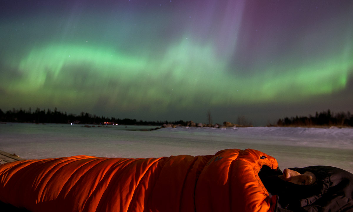
I never saw the Northern Lights in so many variations in a single night. Sometimes there were some small, but very bright Northern Lights in several directions. It looked like a photo exhibition. Sometimes huge green and violet garlands and vortexes covered the sky. Sometimes the whole sky was filled with faint Northern Lights flickering and whizzing around as I never watched it before. Most time lapse videos are lame in comparison. And when I woke up round half past three a bright crystal star of Northern Light gleamed right above me in the zenith sending its beams over the whole sky. Just amazing!
These photos are really nothing compared to reality.


Yesterday I had a longing to the Arctic. I yearned for being on Greenland, Svalbard or somewhere in Nunavut. Tonight I was comforted a bit – it’s fantastic to be able to see them just round the corner of my home.
A great night but now I had to catch some sleep, I’m working tomorrow.
… that was the short term Aurora Forecast of Alaska before the server broke down. I never saw such a high level in a forecast before.
Even an hour after sundown the Northern Lights were visible on the blue sky. After a rehearsal with the chamber choir I drove to Harrbäckssand, a small beach near Ursviken. The whole sky was covered with the Aurora, as I never saw it before at home. Unfortunately it was not too bright and faded down while I tried to make some photos.
Therefore just two photos for now:


Just some final thoughts – quite unordered and far from being complete.
Friends – I made the journey alone, but I spent time with friends. In Haukenes on the Vesterålen, in Kurravaara and in Murjek. At Solberget in Swedish Lapland, in Abisko/Björkliden, and finally in Kirkenes near the Norwegian-Russian border. Sharing time, thoughts and experiences with others is always great and I really enjoyed the time I was allowed to spend with old and new friends.
Conclusion: Share more time with friends!
Being outdoors – When I look back I remember mostly my outdoor trips. Some examples:
Each tour gave me the impression of being in the right place and doing it right. I realised again, that I just adore being outdoors, especially in the kalfjäll – the alpine tundra above the tree line.
Conclusion: Be outside – it feels good!
Driving alone – This journey involved a lot of driving, sometimes the whole day. I consider this both boring and exhausting. Boring because you cannot share your thoughts (see Friends above), exhausting because I had to drive every single of the 6630 kilometres by myself. Sometimes I couldn’t enjoy driving as much as I hoped, I was just glad to arrive somewhere.
Conclusion: Take a friend, drive less or just stand it.
Tenting and short days – Short days aren’t any problem if you have a cabin or another warm place to stay. They are less fun, when you’re still driving without knowing whether you’ll find a cheap overnight stay. They are hard, when you lie alone in your tent and it’s pitch dark outside already at five o’clock. Again boredom is the main problem (see Friends above, again) and time as well since it may take much time to find a place for tenting, erect the tent, cook your meal, do the dishes and so on. That’s why I tented only once (and slept two other night in my tent too without the need to cook).
Conclusion: Take a friend or avoid tenting when days are too short.
Some old favourite places:
And some new discoveries:
When I wrote about my paddling yesterday I was asked in a comment, why I travel at all, when I can have this right on my doorstep. I’ve been living in Skellefteå and Skelleftehamn for almost five years and a lot of winter experiences are really just round the corner:
It’s all right as long as it’s winter!
Let’s make it short: I feel betrayed by the winter this year! It was too windy and it was too warm! Much too warm. And when it snowed, I was far away.
First of all it was too warm – the average temperature of the whole February was 8 °C too high in parts of central Swedish Lapland. That’s about the same difference as between Stockholm and Rome! The whole february! And March wasn’t better. The “all journey minimum temperature” I measured was only -24 °C, I expected temperatures near -40 °C, at least once.
And it was very windy – Norway got its hurricane Ole with average wind speeds up to 36 m/s (that’s level 12 on the Beaufort scale) and gusts up to 53 m/s (that’s level 16 on the extended Beaufort scale!). But many others days were windy and stormy, too, even if not so severe as hurricane Ole.
Most trees where free of snow. Either the snow was blown away or it just melted and dropped down. That made not only the pine forests looking quite boring, but also the snow looking quite dirty, since it was covered with leaves, needles, small branches, bark and much more.
That didn’t look like the untouched, virgin winter landscape in early February but more like city parks in late April, a minor catastrophe for photographers who want to show impressive winter images. Luckily there were exceptions and I got at least some wintry images with snow covered trees, even if only a few.
Yes, it has been cold in January. Some days. In Sweden, but not in coastal Norway where I was at this time. Yes, it snowed ridiculously much in the first days in February, both in the coast and in central Lapland, but not in Abisko in the western mountain region, where I was at this time. It was a bit like being in the wrong place at the wrong time. Later, when Ole arrived, big amounts of snow where forecasted in the mountains, but I considered the weather too dangerous to drive there. As in early February I only saw the results, never the snow fall itself.
And then came the warmth. Since the 24th of February I’ve measured temperatures above zero almost every single day. And this effect wasn’t local, it took place in the whole Northern Europe. In Norway, in Sweden, in Finland. Streets were icy, snow was crusty and I was just glad when it didn’t rain.
Yes, when it comes to weather I am really disappointed. It was the lousiest winter ever, that I experienced north from the polar circle, where I’ve been travelling round since January 2003 now.
Don’t get me wrong! The journey was great, but mostly it was great despite of the weather, not because of the weather.
Last winter was quite bad, too, this winter lousy, now I hope, that winter 2016 will be extraordinary cold and snowy and that I’ll find the time to travel around again.
55 days – 6630 kilometres by car – Sweden – Norway – Finnland
“4:45” showed the clock when I woke up this sunday. Seventy minutes later I stood at the shore – just on time to see the sunrise. My kayak still was fixed on its cart with paddle, camera and dry suit inside.

I put on the dry suit, pushed the kayak into the water and started the tour. When I left home it was -6 °C and parts of the sea where covered with thin new ice. Thin enough to melt under the day but thick enough to give me a hard time to break through with the kayak.
I’m always a bit nervous when I stick my paddle into the ice. Will it break one day? But until now it went well. Sometimes it was easier to take the hand and pull the kayak ahead. And sometimes, when the ice got really thick I used the paddle to hack small holes into the ice that I used as handles for pulling me forward.
But after a time I reached open water and paddled along some old ice floes that were much, much thicker.


And a bit later I came to the huge icy surface, that lays between the mainland and the islands Norrskär and Bredskär. I got out and stepped onto the ice. I think, this is the first time that I stepped onto the sea ice from my kayak. I wasn’t nervous, first of all is this old ice really thick, I should guess at least 30 centimetres, probably more. Then I always wear my completely waterproof immersion suit when I make a kayak trip in winter.


After a short break I continued the tour and headed to the island Gåsören. On the outer shore there were some impressive ice floes left.


It took a while until I could go ashore, because I had to cross another field of new ice. I took a longer rest and took of the dry suit. Ugh! Like always I sweated in the thick neoprene suit and now I smelled like a dead Puma. I took on some other clothes and first it was quite chilly. The spring sun however had enough power to warm me up and soon I took of my gloves and cap.
Most snow has melted and beside of the ice covered rocks at the eastern bank Gåsören almost looked like spring was here.

After a while I dressed for paddling again, entered the kayak and returned to the starting place. With the last ice behind I had a beautiful view of the islands Klubben, Flottgrundet, Gråsidan and Nygrundet. With the blue sky and the blue sea I had the feeling of leaving the winter behind me and paddle into the spring.

When I was home again the thermometer showed +7.3 °C. Almost spring!
Let’s see which animals I got to see under my journey Nordkalotten 2015:
Three moose. The first one I saw from the inside of a house. A big male that walked on the road with a car slowly following. The other two I saw from the car.
Article: Where to go? Undecided yet …

Countless reindeers. Reindeers are so common that I saw them many, many times (and I don’t count the tame or the fenced in ones). Several times I had to slow down or to stop because of reindeers being on the road. Sometimes they do not leave the road but instead start to flee. It’s a bit funny to follow the tails of four galloping reindeers with the car but it must be exhausting for them and I’m always glad when they leave the road.
The reindeers in Northern Scandinavia aren’t wild animals, they always belong to a Sámi family. You see them pulling sleds, posing for photos or even participate in sledge-races.
Articles: Reindeers – many, many reindeers · Jokkmokks marknad


The first fox I saw as a pair of eyes glimmering in the darkness while I drove car. The second one I saw from the car, too on my journey to Kirkenes. I took first same photos from the inside of my car. I tried to get nearer, but the fox went away and disappeared soon.

I saw a mountain hare near Abisko. It looked at me from a hill above. I didn’t even try to follow, since mountain hares are a zillion times faster than me with skis in deep snow on hilly and forestry terrain. No photos therefore.
We saw a seal in the harbour when we started the whale safari in Andenes. Since we were told to protect our cameras from spray and waves we all had our cameras in. No photo neither.
Yes I saw whales and more than expected. A great experience!
Article: Whale watching in Andenes.


Some. A pair sitting on the breakwater in Andenes. It was too dark for taking photos. I saw some flying here and there but too far away.
Only two (which is a sign that I’ve been less out in nature as planned). One from the car, one in the valley Vistasdalen on a ski tour with Annika.
Article: A day trip into the valley Vistasdalen

Twice. Some at the shore in Tromsø and a larger group in Olderfjord. This was a short but awesome experience seeing them fly away and return to the same place again.
Articles: Purple sandpipers and Tromsø: At the shore.


Twice. Some at the Polcirceln and two near Kirkenes. They were much to shy for me to get good photos, so I publish a bad one ;-)

Of course there are many, many more species in Northern Scandinavia but especially the big carnivores – bear, lynx, wolf and wolverine – are extremely rare to see. Most bears are seen from the car, but not in wintertime when they have winter rest. And to be honest, I don’t want to meet a bear when hiking in the forest.
I didn’t mention the Huskies, of course they are animals, too. But I thought more about the animals found in the wilderness, when I wrote this article. Anyway, some links to articles with photos of huskies:
Articles: Kirkenes: A night in the snow hotel · Jokkmokks marknad
These curious, cuddly fellows belong to the Nøisomhed Gård in Haukenes, where I stayed right in the beginning of my journey.

I’ve been home again for some days. The weather in Skelleftehamn is between winter and spring. The sky is clear and the nights are cool (last night for example -7 °C) but as sun the sun comes out the temperatures rise soon to degrees above zero.
Parts of the ground are covered with hard snow – in my backyard i measured 45 cm – but other parts are completely free of snow and I’m waiting for the first flowers to come out and blossom.
The Baltic sea is mostly free of ice, but near the shore and in some sheltered harbours there is still a thick layer of ice covering the water. And since the night was quite cold, parts of the near harbour that was completely open yesterday was covered with thin new ice this morning.
Two photos that I made near the small boat harbour Tjuvkistan this morning:


I could walk over the ice to some islands that still are connected to the mainland or I could take the kayak and paddle to some islands, too. But to be honest – I’m quite lazy after the long journey and I guess I stay home today and take it easy.
