Spring is postponed
Some pictures from yesterday.


Some pictures from yesterday.
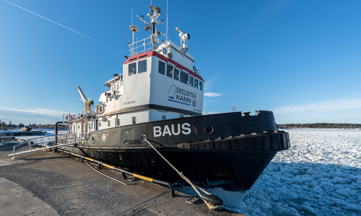
This morning I saw not only the ice fishermen, but also the icebreaker Baus clearing the ice in the port of Skellefteå in Skelleftehamn. In the afternoon I remembered, that I had come into contact with K., one of the crew members on Facebook some weeks ago. I had asked if it was possible to go with the Baus to take photos sometime. K. had answered that I should just go there and ask the people. And so I did today.
I met a guy who works on the icebreaker and learned that it’s hard to make some kind of appointment. In winter no one knows exactly, when ships will arrive or depart due to the weather and the ice conditions and therefore neither when the Baus would start. But they would actually leave in twenty minutes to clear the ice for the ship Ice Star and I was allowed to join …
Sixteen minutes later I was at the dock again, this time with better clothes and my camera equipment that I got from home. How good that I live so close.
I was allowed to enter the Baus and say hello to the captain on the bridge.

He welcomed me, showed me some of the controls to steer the boat and allowed me just to go round everywhere to take photos. I didn’t want to disturb him, because he had to focus on his work and my plan was to make photos, not to interview the crew. At first I went up onto the top deck.


The water was completely covered with crushed ice. Some of the ice floes were at least half a metre thick. Slowly the Baus departed from the dock and I went down to the bottom deck to be closer to the icy sea.


While the Baus was slowly moving back and forth I went on every possible deck. I really enjoyed that freedom that you never can have on bigger ships as e.g. the Hurtigruten ships.


After some time of waiting and some time of moving around the way was clear for the Ice Star. Slowly it departed and followed the cleared channels between the solid ice where it with increasing speed left “Skellefteå Hamn”, the port of Skellefteå in Skelleftehamn.


While my eyes followed the Ice Star I spotted something blue at the horizon. Water! Somewhere behind the island Gåsören the ice had started to break and now open water covered the Baltic Sea behind Gåsören. Maybe the next paddle tour is closer than I think.

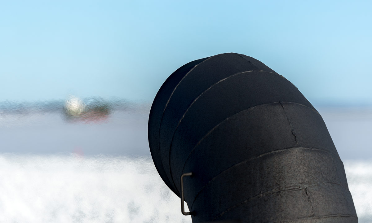
The Baus already had started to turn around (the previous photo shows the funnel at the rear) and return to the dock. I enjoyed watching the different types of ice.


Until now, the trip was extremely calm, now it started to get more rumbling, because Baus now went through packed ice – crushed ice that had frozen together and now was split into large irregular chunks. Great channel-like cracks developed in the ice, which soon closed again.

After some more minutes the Baus arrived and after thanking the captain for the opportunity to follow I left the icebreaker. The whole trip took less than 90 minutes, but felt much longer. I’ve been living in Skelleftehamn for almost eight years and it was a great experience to see my place of residence from a completely new perspective.
Thanks a lot, crew of icebreaker Baus!
Seeing the blue open water was a welcome spring sign. I saw two others today:
The first butterfly of the season, a small tortoiseshell that fluttered around the top deck of the Baus and (perhaps less romantic) the first teenager in shorts in front of ICA, the grocery store. I’m still waiting however for the first wild spring flower in Skelleftehamn.
I guess, this week has been the ice fisher’s delight. Nightly temperatures between round -8 °C (good for the ice), afternoon temperatures round +8 °C, hardly any wind and no clouds hiding the sun (good for oneself).
It’s really hard for me to focus on my work when weather is as nice as it has been the last weeks. I would prefer having holidays in the mountains enjoying the fabulous late winter weather. I guess however that there are times when I have to earn money, too …
Already at 8 o’clock I saw five ice fishers standing, sitting or lying on the ice with their tiny plastic fishing rods. Although it was -6 °C it was warm in the sun. In the background the icebreaker Baus circuited around to break the ice for the next ship to come.


I knelt on the ice to make the photos above and heard it cracking. Was it thin ice? Not at all, it is still thick and safe. I guess it was the waves caused by the Baus that made the ice swing and crack. A strange experience. Good to now however that the water is quite shallow where I went.
But now I have to continue my work …
I didn’t work much more today, sometimes there are spontaneous opportunities to seize …
This article is part of the series “2018-03: Varanger peninsula”.
Some unpublished photos from my winter journey. I want to show them as long it is still wintry here.
While the grown-up huskies are doing their job the puppies have to wait in the trailer. I guess it is very boring for them. There are curious and seek contact.

While Chris, Annika, Ørjan and I are enjoying the gorgeous breakfast in the hotel Thon an asian tourist is waiting outside. She seems to be well protected against the elements but why has the fur to be pink …?

On the way to Kiberg Annika and I make a stopover in Ekkerøy where we enjoy a beach walk. Here we meet H. who invites us to visit her. We will make that true some days later. I take a photo of Annika’s and H.’s footwear. Tradition, meet modern world.

Cape East Arctic Adventure, our stay lies directly at the beach. I could spend weeks with only watching the tides and the changing weather.


There’s hardly any commercial fishing left in the small former fisher villages and the large drying racks for drying cod remain empty. Some people however still dry cod for personal usage.

A view through the window of Cape East Arctic Adventure. Today we will continue our journey.

We hardly have the time to explore Berlevåg, we only buy food. Two images of Berlevåg anyway. Just for the records …


This snowstorm shaken rocky shore appears more arctic than many other places of this journey.

A woman has found a wind protected place and watches the Norwegian winter landscape.

On our long car trip back from Ørnes to Skelleftehamn we pass Saltstraumen, a small strait with one of the strongest tidal currents in the world. We are too early to see the strongest maelstroms and I’m too eager to continue home. It’s still 500 km to drive.

Now I finally can erase my “later” folder on the computer.


Dramatis personæ:
Source: MarineTraffic. The assembled information is supplied without liability.
When the sea ice is safe + the weather is calm and sunny + it’s Easter holidays you can bet that many, many people are outside. A zillion times more than in January or February when the locals think it’s too cold.
Some people walk, some even ski but most people use their snowmobiles. And that’s how the snow covered ice on the Baltic Sea looks like: covered with snowmobile tracks. Sometimes only one or two of them, but often it’s many tracks making the ice look like a German autobahn.


What a contrast compared to my hike less than two weeks ago where I was almost alone on the ice.
Yesterday at 17:40 my tent was set up on a snowy plane near the sea ice where I planned to stay for the night.


The dinner was part luxury (a really cold coke), part pragmatism (some instant curry chicken of dubious consistency) and part necessity (chocolate!). After the dinner I walked along the shore, which was completely covered with ice and snow. First I walked on land, then on the sea ice. You may think, that a landscape that solely consists of snow and ice must be quite colourless, but no, when there’s light there are colours!


When I came back to my tent, it already had become dark and the almost full moon hovered over the tent. And that was my view from the tent, too: The moon, some stars, snow, ice and the icebound sea.


You might wonder, where I am. Good point, I’ll explain. Let’s go back half a day.
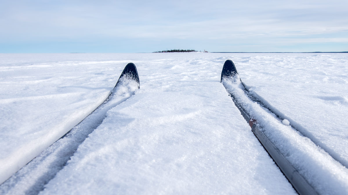
Yesterday I worked only half a day and was home early. I had a plan in my mind: as long as the sea ice is as thick as just now, why shouldn’t I ski over the Baltic Sea to the island Gåsören and spend the night there. I’ve done that in summer twice by kayak but never in wintertime. So I picked myself up, packed skis and pulka and took the car to the small harbour Tjuvkistan.
While the Baltic Sea was open one year ago it is still covered with thick ice this year. Instead of open water one can spot only a snow covered plane and some tracks – made by hare, a moose, another skier, but mostly by snowmobiles, the favourite winter vehicle of many locals. I however do not own such a snöskoter but prefer skiing anyway.
The linear distance between Tjuvkistan and Gåsören is only 2,3 km and so I arrived at the island soon. In summer it’s hard to find a tenting place (I know only one), since almost the whole island is covered with stones and rocks. This winter however Gåsören is covered with at least 50 cm of snow and so it was easy to find a good place to tent. Scroll up to the first photo and you see it.
OK, back to the story …
At nine a clock it was quite dark and a layer of clouds approached. Good arguments for cuddling up in my warm down sleeping bag and go to sleep. Good night, world.
At five a clock I woke up and felt fairly well rested. I got up for taking some photos. Although it’s already the end of March the nights can be quite chilly and I guess that we had temperatures round -10 °C. I put on more or less all clothes that I had with me and made some photos. The moon had wandered on its orbit to the west and hovered above Gåsören’s old lighthouse.

That photo looks like being shot at the dead of night, doesn’t it? So let’s turn around and look to the east:

It’s less than 8 minutes between the previous two images and it’s more the cardinal direction than the time difference that is responsible for the different light and colours. I walked around for two hours and was just happy to be there at that fantastic place that fantastic morning and to experience all these different kinds of ice and light.


I became hungry so I returned to the tent. or tried … . Just a photo of the lighthouses behind the ice. And another one of my camp site.


But now: finally breakfast. Water, crisp bread and cheese. That may not be the most exciting food, but I didn’t care, I enjoyed the incredible view over the icebound Baltic Sea in winter.
After breakfast I walked around another time and took some more photos.


Another break. This time just pure luxury. Since I wasn’t in a hurry the tent was still set up. So I could cuddle up in my cozy sleeping bag again and took a long daytime nap. The temperature was still below zero but the sun was high up in the sky and warmed the tent. And there was even chocolate left. Just “gemütlich”!
When I woke up an hour later a layer of stratus clouds had approached and the light had become dull. A good time to pack anything back into the pulka, to put on my skis again and to start the “long” way home. Good bye, Gåsören. Next time when I visit you it will probably be with the kayak. I love winter, but paddling in summertime is great, too.
When I had arrived at the car after Jonas’ and my previous ski tour, it was in Kvikkjokk, 400 km from home. This time the car was parked less than 3 km from my house. I’ve been living in Skelleftehamn for many years now but still I’m happy about the beautifulness of it.

This article is the first one of the new series #escapism. It’s about being outdoors and leaving civilisation behind in excursions that take less than 24 hours. Everyone should have time for such!
tent with snow pegs · inflatable camping mat · down sleeping back (a warm one!) · clothes for skiing · spare clothes · winter anorak · thermal pants · warm boots · woollen cap · 2 pairs of gloves · down west · skis with poles and boots · pulka with hip belt · water (both cool and hot) · food (a lot!) · knife · camping stove · matches · kitchen stuff · mobile phone · power bank · headlamp · sunglasses · thermometer (it broke) · compass · isdubbar (essential emergency equipment in case of breaking into the ice) · toilet paper · snow shovel · camera equipment · tripod · grand piano (just kidding)

Sunrise at 5:23 · clear blue sky · -14 °C (quite low for the season)
… and if you think, that’s cold, in Nikkaluokta it’s -30 °C right now.
According to the meteorologists spring already had started on 1 March. They love to calculate in whole months. Astronomically the beginning of spring is just today.

Well, kind of …
Today I didn’t work but enjoyed the marvellous weather. Bright blue sky and sun, a good day to go to the beach.
Well kind of …
The temperatures were between -10 °C and -5 °C and the Baltic Sea is still covered with a thick layer of ice up to the horizon. Sometimes it’s solid ice, sometimes it’s packed ice. No open water is in sight and therefore no sea birds neither. Just snow and ice and the blue sky.


I left the mainland at the boat harbour Tjuvkistan and crossed the ice to the islands Norrskär and Bredskär. Now I walk along the eastern shore of Bredskär and then to the island Gråsidan.

At the eastern shore there’s a long wall of ice, up to two meters high.

I walk along the shore and look at the fantastical landscape of ice and snow. Sometimes I feel like being in an open air museum. I call the exhibitions “below zero, above sea”. Here’s one of my favourite exhibits:

I go round half the island and then cross it. Although the snow feels solid – like that green floral foam used for flower arranging – I mostly sink knee deep into it. I walk back along the western shore and then cross the ice to the southern edge of Bredskär. The island has a ice wall at the eastern shore as well, partly up to four meters high. Where shall I go? Right beside of the ice wall there are snow drifts, knee deep or even deeper. A bit farther there’s water between the solid ice and the covering layer of snow. Good to have rubber boots.

I cannot decide for the best way to go. So I’m walking king of zig-zag, constantly watching the ice edge. Sometimes there’s a long line of icicles …

… and once there’s even a quite large ice cave. A pity that it will melt within the next weeks (or months?).

I continue my walk, sometimes plunging through deep snow, sometimes just walking on solid ice, sometimes breaking through the snow into water and slush (don’t worry, there’s always a thick layer of ice beneath). I cross the natural gravel bank between the islands Bredskär and Norrskär and talk the same way back to Tjuvkistan.
Today I walked only round seven kilometres, but it was good to be outside, breathing air, letting my eyes wander, catching some sun and the colours of the sky. At 12:30 I reach the car. It’s very warm in the sun and I’m dressed too warm, but the air temperature is still -5 °C. It’s a season between winter and spring which is called vårvinter – spring-winter. A suitable name.
And here comes my favourite picture of today’s exhibition-expedition. I call it “layers of ice”.

Side note: did you notice the huge rubber boots I’m wearing on the first photo? I bought them in Murmansk a month ago. They are made for ice fishing and they are lightweight, comfortable, very warm and of course waterproof. And they were quite cheap. The only drawback: They have spikes that do the opposite of what they are made for. Instead of improving the grip the spikes just slide on the ice making the boots incredibly slippery on ice. I have to check if I can remove the spikes.
This article is part of the series “2018-03: Varanger peninsula”.
Day 38 of my winter journey 2018
After our lonely drive over the kalfjell we approached the coast again. First we spotted small forests, then quite a lot of cabins and finally the Kongsfjorden. The landscape looked much wilder and rougher with steeper mountains and quite inaccessible coast lines than the eastern coast of the Varanger Peninsula, that we just left two days ago.
After some kilometres we approached the village Kongsfjord.

Although this village has hardly more than 30 inhabitants it has however a grocery, that acts as a museum and a café as well. After it had been closed for some time, the new owners had opened it last August and keep it open all the year.


We went round the small town a bit too but continued then to Kjølnes Fyr, 5 km before Berlevåg where we planned to stay for one or two nights. Some impressions of Kongsfjord’s harbour area in wintertime:


By the way: Now it’s two days later and Annika and I are actually sitting in the very same café in Kongsfjord while writing this blog article. We’re waiting, but that’s another story …